Letcher County sits in the Appalachian mountains of eastern Kentucky, where towns, roads, and streams occupy narrow valleys between closely spaced ridges. Whitesburg is the easiest starting point for reading the county, while Jenkins and Fleming-Neon help define the eastern side and Blackey provides a useful western reference. The supplied map set separates boundary and road information, city connections, waterways with shaded terrain, and elevation so each layer stays legible. The original high-resolution JPG map files can be downloaded from the file box near the end of this page for printing, classroom work, presentations, or offline reference.
The official Letcher County website identifies Whitesburg as the county seat and lists Whitesburg, Jenkins, and Neon among the county’s independent city governments. The city-connections map in this package uses the label Fleming-Neon, so the article follows the labels visible on each map while keeping official administrative information separate. This distinction matters because the purpose of these maps is geographic orientation rather than a complete legal or municipal directory. Used together, the four views show why short straight-line separations can correspond to winding road trips and why the county’s river valleys are central to understanding settlement.
Table of Contents
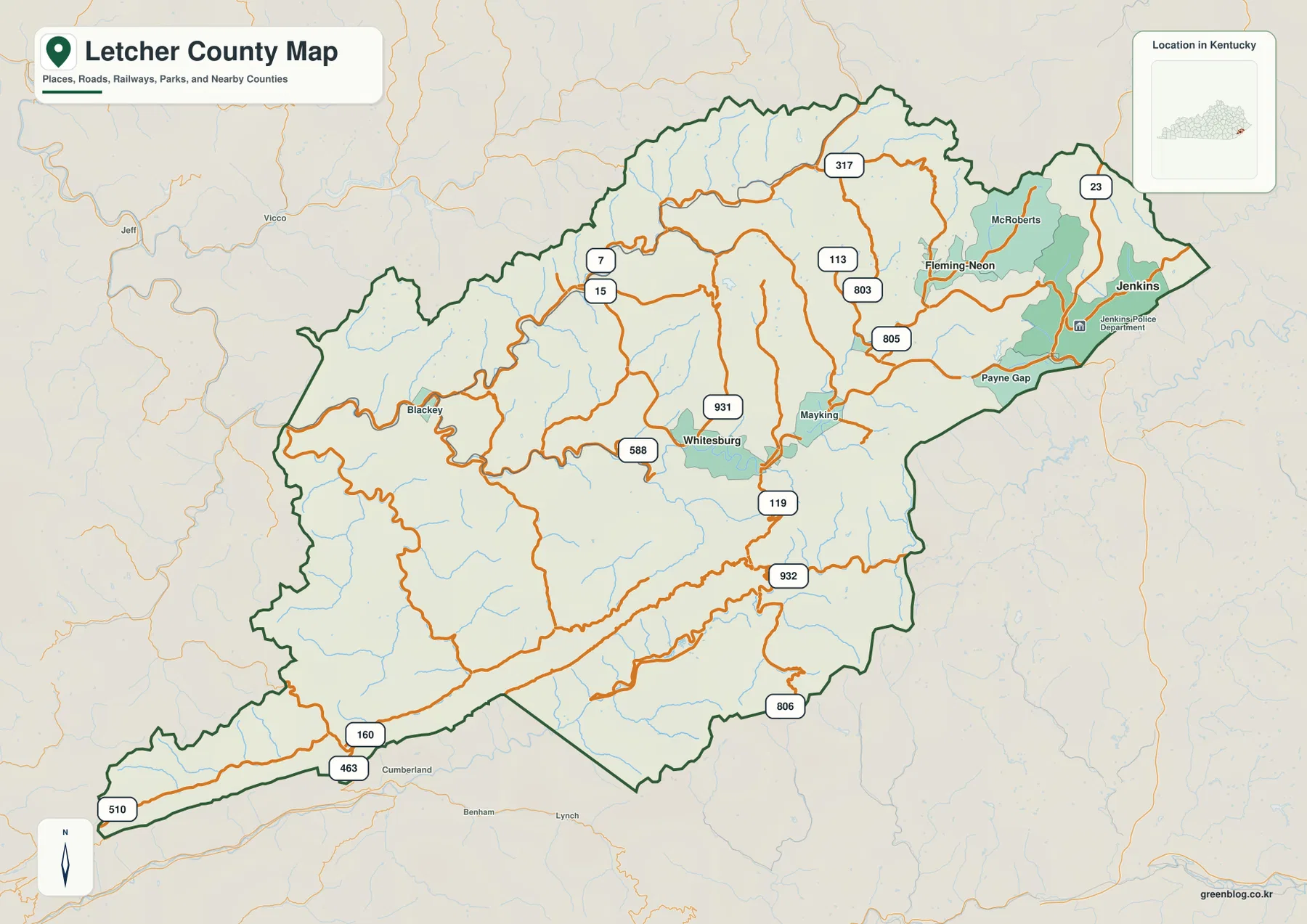
Whitesburg provides the clearest anchor for the road map
The county map places Whitesburg slightly east of the county’s center, close to Kentucky Route 119 and several smaller numbered routes. Routes 588 and 931 are labeled nearby, while Routes 15 and 7 appear to the northwest. Farther northeast, Routes 113, 803, and 805 serve valleys leading toward Fleming-Neon and nearby communities. The lines rarely form a regular grid. Instead, they curve repeatedly through the interior, a pattern that becomes much easier to understand after looking at the water and elevation maps.
Moving east from Whitesburg, the map passes Mayking before reaching Fleming-Neon, McRoberts, Payne Gap, and Jenkins. U.S. 23 is marked close to Jenkins near the eastern edge of the county. This eastern group of places contrasts with Blackey on the western side and the long southwestern extension of the county, where Routes 160, 463, and 510 provide recognizable reference lines. The boundary itself is irregular and elongated, reflecting a mountain region in which valleys and ridges are more useful geographic guides than a simple rectangular outline.
Other numbered roads help divide the county into smaller areas. Route 317 crosses the northern portion, while Routes 932 and 806 appear in the southeastern and southern interior. These labels are useful for orientation, but the map should not be treated as a live traffic service. It does not report construction, closures, winter driving conditions, or travel times, and it is not a parcel or property-ownership map. Its strength is regional context: it shows where the named communities and major numbered routes sit within the county boundary before the reader moves to more specialized views.
Three city markers reveal an eastward concentration of settlement
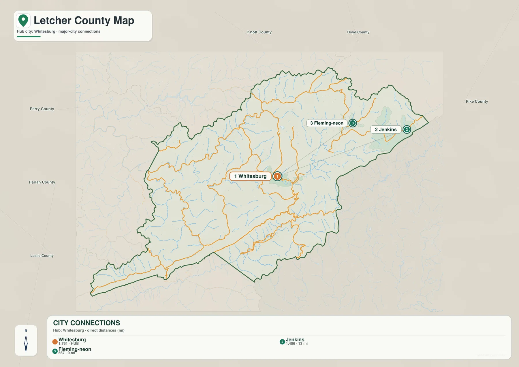
The city-connections view removes most secondary road labels and concentrates on Whitesburg, Jenkins, and Fleming-Neon. Whitesburg is designated as the hub, with Jenkins shown about 13 miles away and Fleming-Neon about 9 miles away by direct distance. Those figures are straight-line measurements, not driving distances. In a county with steep ridges and winding valleys, a road route can be substantially longer than the line between two points, so the city map is best used to understand relative position rather than to estimate a trip.
Whitesburg occupies the central part of the map, Fleming-Neon lies to the northeast, and Jenkins sits farther east near the county boundary. The simple connecting lines make the eastern cluster easy to see, but the detailed boundary map adds the missing context: roads between the communities bend around terrain and pass through narrow valleys. Comparing the two maps helps explain an important geographic feature of Letcher County. Places that look close in a simplified diagram can still be separated by mountain relief that controls where roads can go.
The surrounding county labels also provide useful regional orientation. Knott and Floyd counties are shown to the north, Pike County to the east, Perry County to the west, and Harlan and Leslie counties along the western and southwestern sides. This frame places Letcher County deep within eastern Kentucky’s mountain country rather than as an isolated administrative shape. For a report or classroom slide where the main question is “where are the principal cities relative to one another?”, this uncluttered map can communicate the answer more quickly than the full road map.
Two major river systems organize the county’s valleys
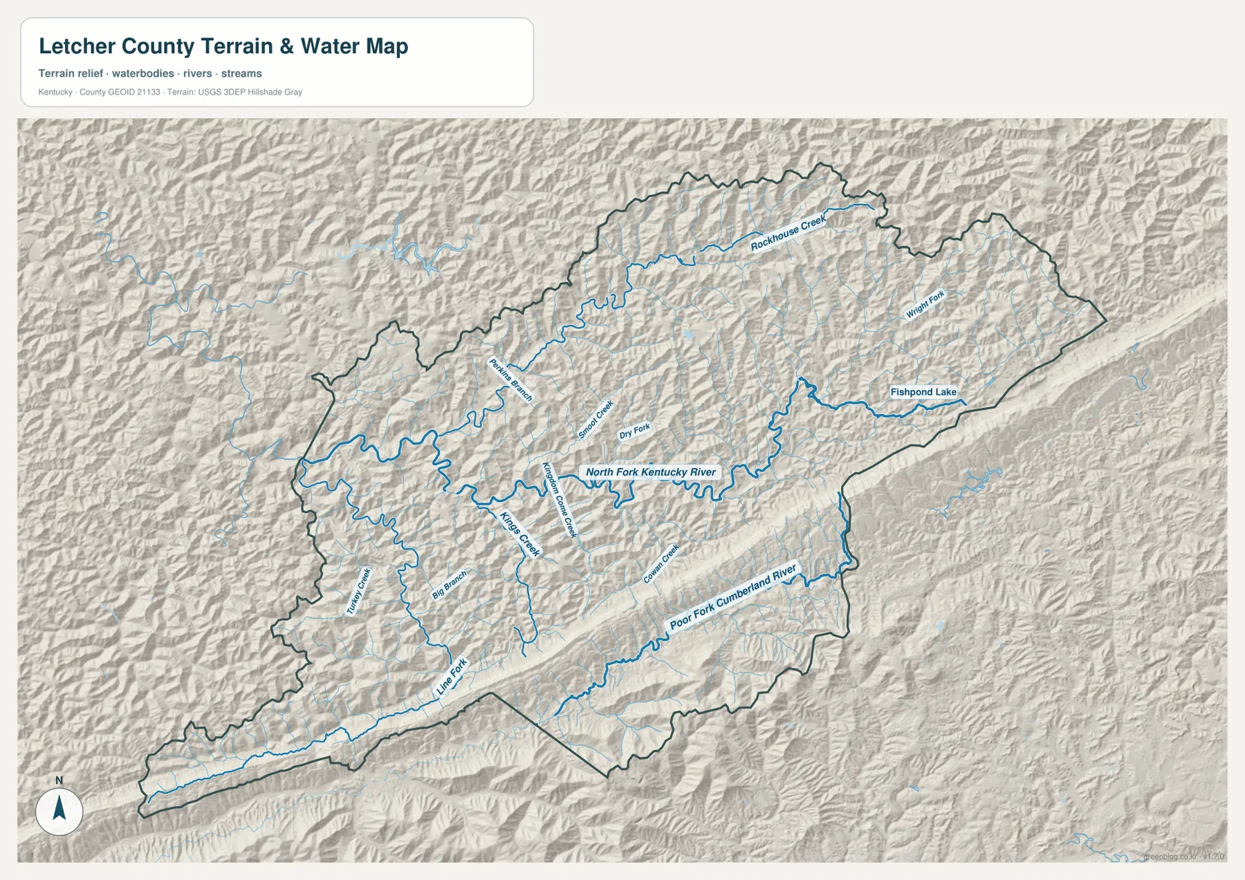
The terrain-and-water map shows a particularly distinctive feature: Letcher County contains valleys tied to two major river systems. North Fork Kentucky River is the dominant named channel across the central and northern interior, while Poor Fork Cumberland River runs through the southern portion. A high ridge zone separates many of their tributaries. Instead of every creek joining one central river, smaller streams descend toward different larger channels depending on which side of the mountain divide they occupy.
Several named tributaries make the pattern easier to follow. Rockhouse Creek is labeled in the north, while Smoot Creek and Dry Fork appear closer to the central drainage. Kings Creek, Big Branch, and Cowan Creek occupy other interior valleys, and Line Fork and Turkey Creek help identify the southwestern part of the county. These streams twist between ridges rather than crossing them directly. When the water map is compared with the road map, many of the bends in the road network make more sense because transportation corridors frequently share the same narrow low ground as streams.
Fishpond Lake stands out in the eastern part of the county, with Wright Fork and smaller channels nearby. The official county website highlights Fishpond Lake as a local place for fishing and outdoor recreation, which gives the mapped water body useful real-world context. The lake and creek lines on this map are intended for geographic reference, however. They do not show water depth, navigability, flood zones, access rights, or legal stream boundaries. Those questions require current specialized sources rather than a general terrain-and-water illustration.
For a first-time reader, a practical way to use this map is to locate the two larger rivers before following the smaller tributaries. North Fork Kentucky River helps orient the Whitesburg and central-valley side of the county. Poor Fork Cumberland River explains the direction of the southern drainage. Fishpond Lake then provides a clear eastern landmark. Once those three features are familiar, the dense network of smaller creeks no longer looks random; it becomes a set of separate mountain valleys feeding larger river corridors.
A 287–1,132 meter range makes relief impossible to miss
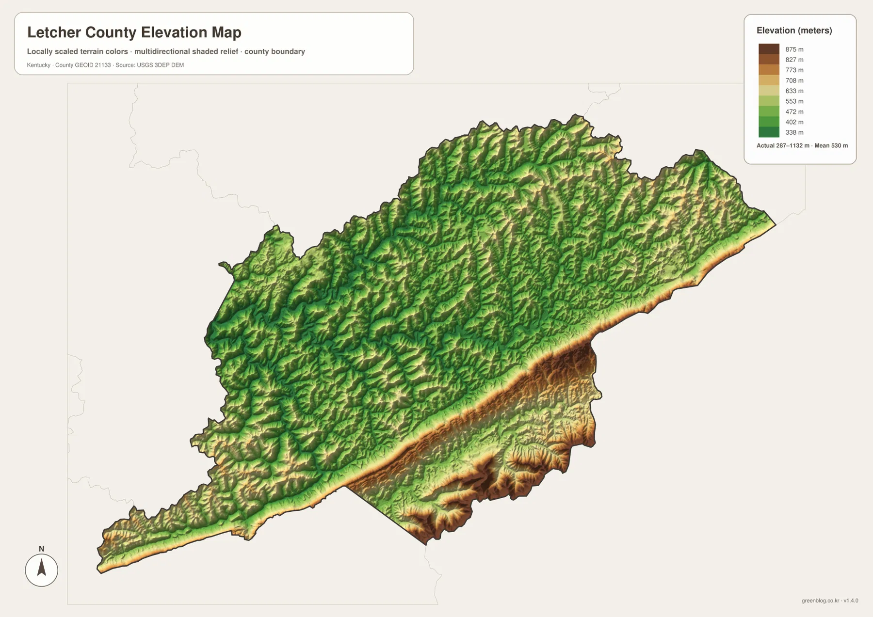
The elevation map reports an actual range of about 287 to 1,132 meters and a mean elevation of roughly 530 meters. Lower valleys are represented with green tones, while higher ridges shift through yellow and brown. The result is not a county that gradually rises in one direction. Instead, the interior is cut into many narrow valleys, and the most prominent high ground forms a long band along the southern and southeastern side. The difference between the lowest and highest mapped elevations exceeds 800 meters, which explains the strong visual contrast.
The high ridge along the southern edge is especially important when the elevation and water maps are viewed together. North of it, numerous tributary valleys feed the North Fork Kentucky River system. South of the divide, Poor Fork Cumberland River occupies a different corridor. The elevation colors therefore reinforce what the water lines already suggest: a major mountain divide helps separate drainage directions within the county. That relationship is more informative than simply identifying the highest color on the legend because it connects relief to the actual river pattern.
Around Whitesburg and Mayking, lower green corridors are threaded between higher ridges. The eastern side near Jenkins shows the same close juxtaposition of narrow low ground and steep surrounding terrain. This is useful context for the settlement map. Towns and roads are not spread across a broad flat plain; they occupy the limited corridors where the land is comparatively lower. A reader can move from the road map to the elevation map and see why the built geography follows long curves instead of straight lines.
The colored surface is suitable for regional comparison, not survey-grade measurement. It generalizes elevation across the county so that valleys and ridges can be recognized at a glance. Anyone needing an exact elevation for engineering, construction, property work, or field surveying should use current source DEM data or professional measurements. For a printed county profile, however, the contrast between the green valleys and the brown southeastern ridge gives a clear visual explanation of Letcher County’s rugged relief.
Reading Whitesburg, Jenkins, and the river valleys across all four views
Whitesburg works well as the common reference point for comparing the maps. On the road map, Route 119 and several local numbered routes meet nearby. On the city map, Whitesburg is the hub for the direct-distance lines to Jenkins and Fleming-Neon. On the water map, the North Fork Kentucky River system shapes the surrounding valleys, and on the elevation map, lower terrain threads through the same central area. Each map answers a different question, but the geographic relationship remains consistent.
Jenkins can be read in a similar sequence. The road map places the city close to U.S. 23 and the eastern county edge. The city map shows its straight-line separation from Whitesburg as about 13 miles. The elevation view then reveals why that simple distance does not represent an easy straight route: high ridges and narrow valleys interrupt the space between the cities. The same method works for Fleming-Neon, which is only about 9 miles from Whitesburg by the map’s direct-distance measure but still belongs to a mountain corridor with winding roads.
Fishpond Lake provides another useful comparison point. On the water map it is an obvious blue landmark on the eastern side, while the elevation map places it within a rugged setting of nearby ridges. Returning to the boundary map then helps relate that natural feature to Jenkins, Payne Gap, and the eastern road network. On the opposite side of the county, Blackey and the long southwestern extension can be paired with Line Fork and nearby valleys to make the western geography easier to understand.
Choosing the map that fits the question
For a general county overview, the boundary map is the strongest first choice because it combines places and major roads in one frame. It is useful for locating Whitesburg, Jenkins, Fleming-Neon, Blackey, and the main route corridors before moving to a more specialized subject. The city-connections map is better when a presentation needs a clean comparison of the principal city markers without the distraction of numerous smaller roads. Its direct-distance labels should always be described as straight-line measurements.
For physical geography, the terrain-and-water map carries the most named detail. It shows North Fork Kentucky River, Poor Fork Cumberland River, Fishpond Lake, and a network of creeks in the context of shaded mountain terrain. The elevation map removes most names and makes relative height the main subject, which is ideal for showing the deep valleys and the high southern-southeastern ridge. Using those two maps together gives a more complete explanation of the landscape than either one can provide alone.
The downloadable package contains the original high-resolution JPG versions rather than the smaller WebP images used in the article body. Each JPG is 3,638 by 2,572 pixels, giving enough detail for larger displays, lessons, and print layouts where stream lines or elevation colors need to remain readable. These maps are reference graphics, not substitutes for legal boundary records, flood studies, navigation charts, or engineering data. The source links below lead to authoritative boundary, hydrography, and elevation resources when a project requires the underlying current datasets.
Frequently Asked Questions
Is the 13-mile figure between Whitesburg and Jenkins a driving distance?
No. The city-connections map labels approximately 13 miles as a direct, straight-line distance from Whitesburg to Jenkins. Roads in Letcher County bend through mountain valleys and around ridges, so an actual driving route can be longer. Current navigation or highway information should be used for trip distance, travel time, closures, and road conditions.
Why do both the Kentucky River and Cumberland River systems appear in one county?
The supplied water map shows North Fork Kentucky River across the central and northern interior and Poor Fork Cumberland River in the south. High ridges separate many of their tributaries, so smaller streams descend toward different larger river systems depending on which side of the divide they occupy. The map is a geographic reference rather than a formal watershed-boundary product, but it clearly illustrates the county’s divided mountain drainage.
What is the most noticeable feature on the elevation map?
The long high ridge along the southern and southeastern side is the strongest visual contrast. The map reports an overall range of about 287–1,132 meters and a mean near 530 meters, while the central river valleys appear in lower green tones. Those colors are useful for regional comparison, but exact site elevations should come from current elevation data or professional survey measurements.
Map File Information
The ZIP archive contains the original high-resolution JPG versions of the Letcher County boundary map, city-connections map, terrain-and-water map, and elevation map. Each image is 3,638×2,572 pixels for printing, classroom materials, presentations, and offline reference.
- File Type: 4 JPG files inside one ZIP archive
Related Maps
Sources and references
County government context, local recreation information, and references to Fishpond Lake and Pine Mountain are available from the official Letcher County website. Information on Whitesburg, Jenkins, and Neon municipal governments is provided on the county’s Municipalities page. A state-level county profile is available through Kentucky.gov.
For underlying geographic datasets, consult the U.S. Census Bureau TIGER/Line Shapefiles for boundaries and transportation features, USGS National Hydrography for water features, and the USGS 3D Elevation Program for elevation data. The maps on this page are intended for geographic explanation and printing, while legal, engineering, and field decisions should rely on the latest authoritative source data.
Green Map creates custom-edited map images using open geographic data sources such as geoBoundaries, Natural Earth, OpenStreetMap, and government open data. These maps are edited visual materials, not raw data files, and are provided for education, documents, presentations, and graphic reference.