You can download four high-resolution JPG maps of Hughes County, South Dakota, from the map file box near the end of this page. The maps cover county boundaries and roads, the relative positions of Pierre, Blunt, and Harrold, named creeks and lakes, and an elevation surface that ranges from about 433 to 627 meters. The WebP versions in the article are lighter for browser viewing, while the ZIP contains the original 3638 × 2572 pixel JPG files.
Hughes County sits near the center of South Dakota, but its shape is strongly influenced by the Missouri River along the west and south. Pierre occupies the western river edge and serves as both the county seat and the state capital. Hughes County’s official history notes that the county was organized in 1880 and that Pierre became the county seat before South Dakota statehood, which helps explain why the road and place-name detail is concentrated around Pierre on the general map.
Table of Contents
Pierre Anchors the Missouri River Edge of Hughes County
The general county map places Pierre close to a broad bend of the Missouri River on the western side of the county. Fort Pierre appears across the river outside the Hughes County boundary, while Oahe Acres is labeled farther north near the river corridor. This makes Pierre a useful orientation point: once you locate the city, the long curved county line to the south and the narrower western river section are easy to follow.
Several numbered highways provide a second way to orient the map. U.S. 83 runs northeast from the Pierre area toward the interior, U.S. 14 crosses the northeastern side near Harrold, and SD 34 follows a long east-west path across the southern part of the county. These roads are useful for understanding direction and settlement patterns, but the map is not a live navigation product. Road closures, construction, and current driving conditions should be checked with an up-to-date transportation source.
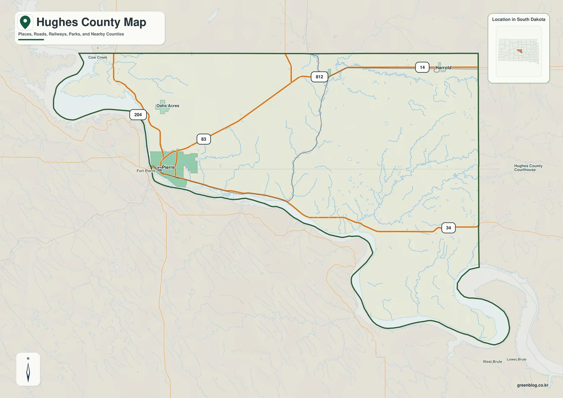
The curved river boundary is not just a cartographic design choice. South Dakota’s codified boundary description for Hughes County states that part of the county line follows the center of the main channel of the Missouri River, and it also specifically includes Farm Island. That legal description helps explain why the outline differs from the mostly straight township-based edges seen in many counties. The blog map remains a reference map, however, and should not be used as a legal survey or parcel-boundary document.
Blunt and Harrold Extend the Settlement Pattern Northeast
The city-connections map removes most of the road detail and highlights three places: Pierre, Blunt, and Harrold. Pierre is marked as the hub on the southwest side of the county. Blunt lies northeast of Pierre, and Harrold sits farther east near the northern part of the county. The simplified layout makes it easy to see that Hughes County’s named communities extend well beyond the capital-city area along the river.
The map labels Pierre-to-Blunt at about 20 miles and Pierre-to-Harrold at about 31 miles. Those figures are straight-line distances, as stated in the map legend, not road mileage. A driving route can be longer because roads do not follow a perfectly straight line. The distance labels are best used for a quick comparison of how far the communities are separated in geographic space.
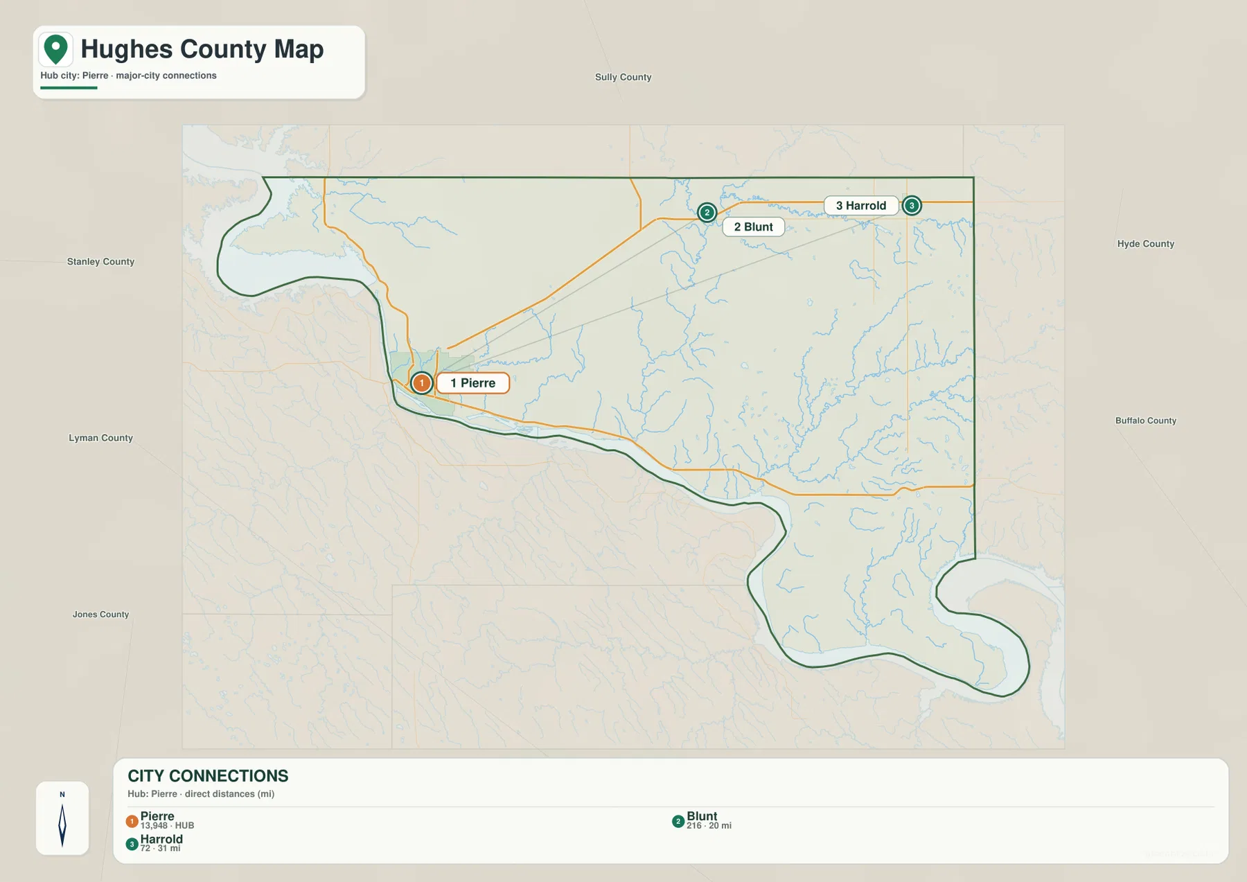
The county’s official history provides useful context for this pattern. It identifies Blunt and Harrold as communities organized east of Pierre in the 1880s. The modern map is not a historical map, but the placement of those towns still gives the northeastern half of Hughes County clear reference points. After learning their relative positions here, it becomes much easier to match the same area on the water and elevation maps.
Medicine Knoll Creek and Chapelle Creek Drain the Interior
The terrain-and-water map shifts attention from roads to drainage. A broad Missouri River corridor defines much of the county’s western and southern edge. Spring Creek enters that river area in the northwest, while Hipple Lake is labeled near the western interior. Farther east, Dry Run and Mush Creek appear as shorter features, and Medicine Knoll Creek forms one of the most noticeable north-south drainage lines through the middle of the county.
In the northeast, South Fork Medicine Knoll Creek is labeled near Woodruff Lake. Gustafson Lake appears farther south, and the eastern half contains Chapelle Creek and South Chapelle Creek with multiple smaller tributaries. Joe Creek is labeled in the southeastern part of the county. Together, these features show that Hughes County is not a featureless plain: shallow valleys and branching streams divide the interior even where the general road map looks relatively open.
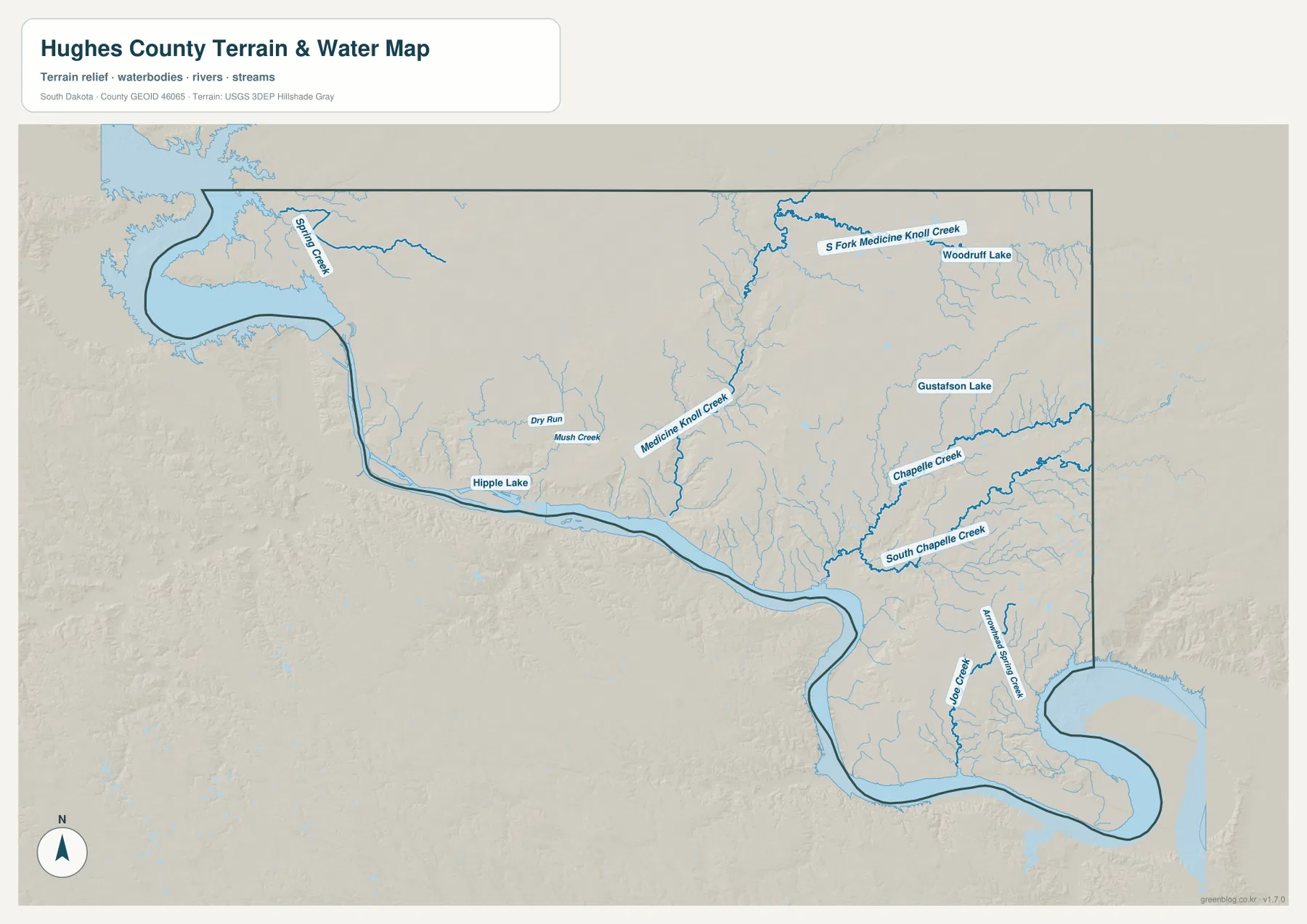
This map is a water-reference map, not a flood-risk, navigation, or legal water-boundary product. A blue line does not indicate a constant channel width or permanent flow throughout the year, especially for smaller creeks and intermittent drainage features. Use current hydrology, floodplain, and field information for decisions involving property, safety, water management, or construction.
Elevation Rises Away from the Missouri River Corridor
The elevation map lists an actual county range of roughly 433 to 627 meters, with a mean near 523 meters. The lowest green tones follow the Missouri River corridor along the western and southern edge, including the Pierre area and the large bend in the southeast. This creates a continuous low strip that is easy to compare with the broad water boundary on the terrain-and-water map.
Moving inland, the colors shift toward yellow and brown as the terrain rises. The strongest high ground appears along the eastern edge, where broad brown slopes stand above the lower central interior. Smaller elevated ridges also occur in the north and east-central parts of the county. Medicine Knoll Creek cuts through a noticeably lower green corridor in the middle, so the elevation map helps connect the named drainage on the water map with the shape of the land beneath it.
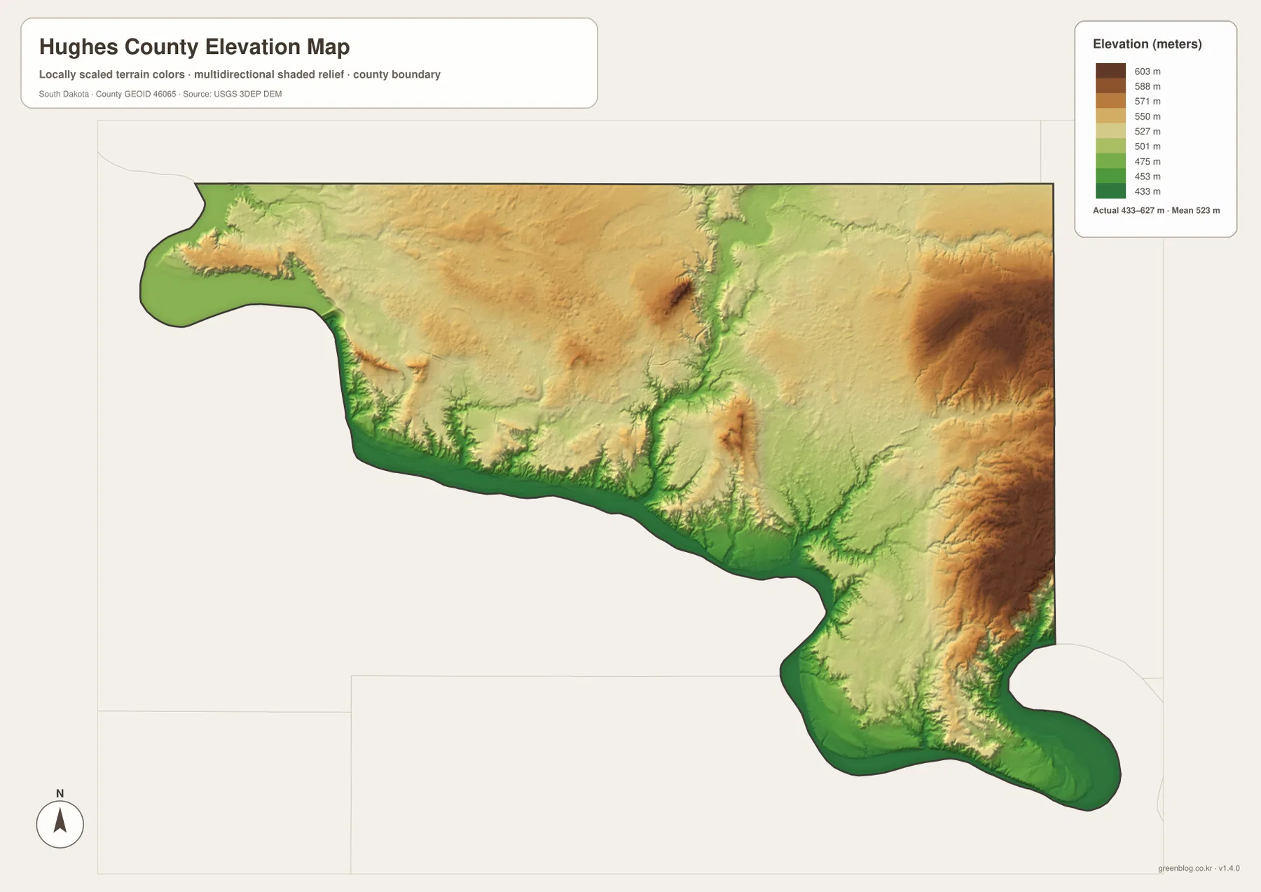
The colors are intended to show county-scale relief, not survey-grade elevations for individual parcels, roads, levees, or building sites. Small terrain details are generalized at this scale. Engineering, drainage design, construction, or boundary work requires the original elevation data and, where appropriate, an on-site survey rather than a value estimated from this rendered map.
Choosing the Best Map for a Hughes County Question
Start with the general map when the question involves Pierre, highway direction, county boundaries, or nearby place names. It is the strongest overview because roads, settlements, the river edge, and surrounding labels appear in one view. Switch to the city-connections map when you only need to compare Pierre with Blunt and Harrold without the visual clutter of the full road network.
For drainage, begin with the terrain-and-water map and locate Medicine Knoll Creek, Chapelle Creek, Spring Creek, and the named lakes. Then compare the same areas on the elevation map: low green corridors often follow the drainage routes, while the eastern brown terrain rises above them. Reading the two maps together makes the relationship between waterways and relief much clearer than either image by itself.
The WebP images in the article are optimized for faster page loading. If you need to zoom into small labels or use the maps for A3 printing, classroom work, presentations, or personal reference, the original JPGs in the ZIP are the better choice. The archive contains four 3638 × 2572 pixel JPG files: the general county map, city-connections map, terrain-and-water map, and elevation map.
Frequently Asked Questions
Are the 20-mile and 31-mile labels from Pierre driving distances?
No. The city-connections legend identifies them as direct, or straight-line, distances. Blunt is shown about 20 miles from Pierre and Harrold about 31 miles from Pierre in a straight line. Actual driving mileage depends on the road route and will usually be longer.
Which map is best for comparing the Missouri River with Medicine Knoll Creek?
Use the terrain-and-water map first. It emphasizes the broad Missouri River edge together with Medicine Knoll Creek, Chapelle Creek, Spring Creek, and several named lakes. If you also want to see how those waterways fit into low valleys and higher ground, compare the same locations on the elevation map.
Can the 433–627 meter elevation range be used for a specific construction site?
No. That range describes county-scale relief and does not provide survey-grade elevation for an individual parcel or structure. Use USGS source elevation data and a qualified field survey when exact height, slope, drainage, or engineering measurements are required.
Map File Information
The ZIP below contains the four original high-resolution JPG maps for Hughes County: the general map, city-connections map, terrain-and-water map, and elevation map.
- Included Files: 4 JPG maps
- Printable Size: 3638 × 2572 px each
Related Maps
Sources and References
- Hughes County, SD – History – Official county history covering Pierre’s role, early communities including Blunt and Harrold, and the county’s river setting.
- South Dakota Legislature – Hughes County boundaries – Official statutory description of the Hughes County boundary along the Missouri River.
- U.S. Census Bureau TIGER/Line Shapefiles – Official geographic boundary and road reference data for U.S. counties.
- USGS National Hydrography – Official U.S. hydrography resources for rivers, streams, and lakes.
- USGS 3D Elevation Program – Official elevation data and 3DEP information.
Green Map creates custom-edited map images using open geographic data sources such as geoBoundaries, Natural Earth, OpenStreetMap, and government open data.
These maps are edited visual materials, not raw data files, and are provided for education, documents, presentations, and graphic reference.