Jefferson County in southwestern Mississippi is easiest to understand by starting with Fayette and then looking west toward the Mississippi River lowlands or east toward the higher uplands. The county is not a flat, uniform rectangle: its western edge bends toward the river, while the eastern half contains a dense pattern of ridges and stream valleys.
This page separates those features into county, city, water, and elevation views so the roads and place labels do not compete with the terrain. You can also download the matching high-resolution JPG files in one ZIP for printing, presentations, classroom use, or offline reference.
Table of Contents
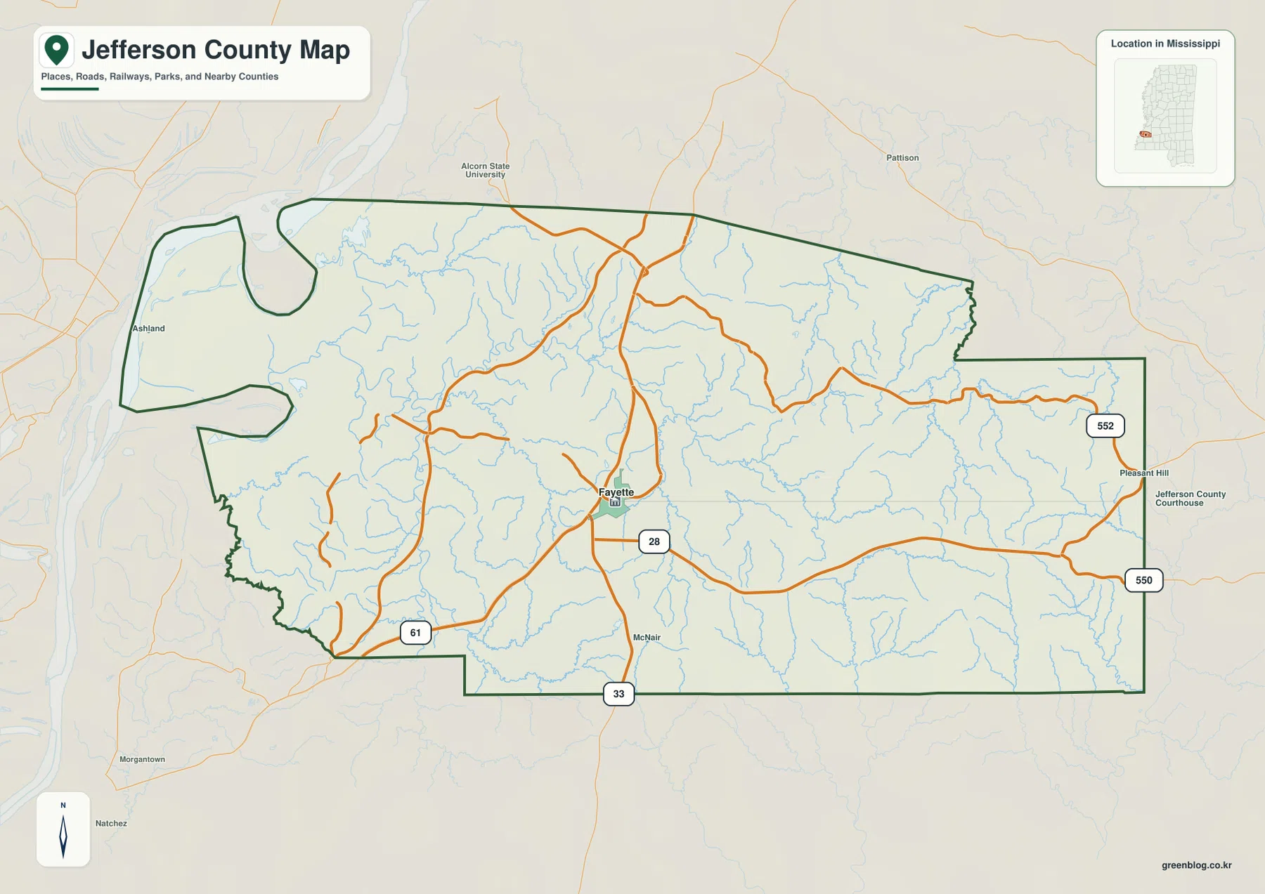
Fayette as the road reference for Jefferson County
Fayette sits near the middle of the county and works as the most useful orientation point on the general map. MS 28 crosses the county through the Fayette area, while US 61 runs north–south closer to the western side. MS 33 reaches the southern boundary, and MS 550 and 552 provide labeled references toward the eastern side. Reading those roads together makes the county’s east–west span much easier to judge.
The boundary itself is distinctive. The west side bends and narrows near the Mississippi River corridor instead of following one straight line, while much of the southern and eastern perimeter is straighter. Labels for Alcorn State University, Pleasant Hill, McNair, and the Jefferson County Courthouse add useful orientation points without turning the map into a street-level guide.
Why the city map emphasizes Fayette alone
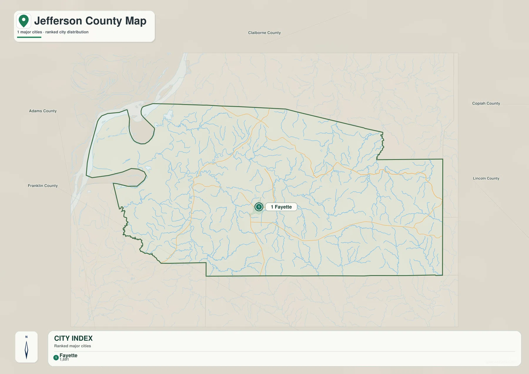
The supplied city map identifies one major city: Fayette. Its CITY INDEX lists Fayette at 1,691, and no second major city is plotted for a connector comparison. That makes this page different from county maps where several cities are linked with straight-line distance labels.
The absence of additional ranked cities should not be read as an absence of rural communities. It only means that, under the criteria used for this city layer, Fayette is the single highlighted city. For local orientation, the better approach is to combine Fayette with the road network, nearby institutional labels, and the stream pattern rather than expecting a dense urban hierarchy.
Creeks, Bush Lake, and the river-side lowlands
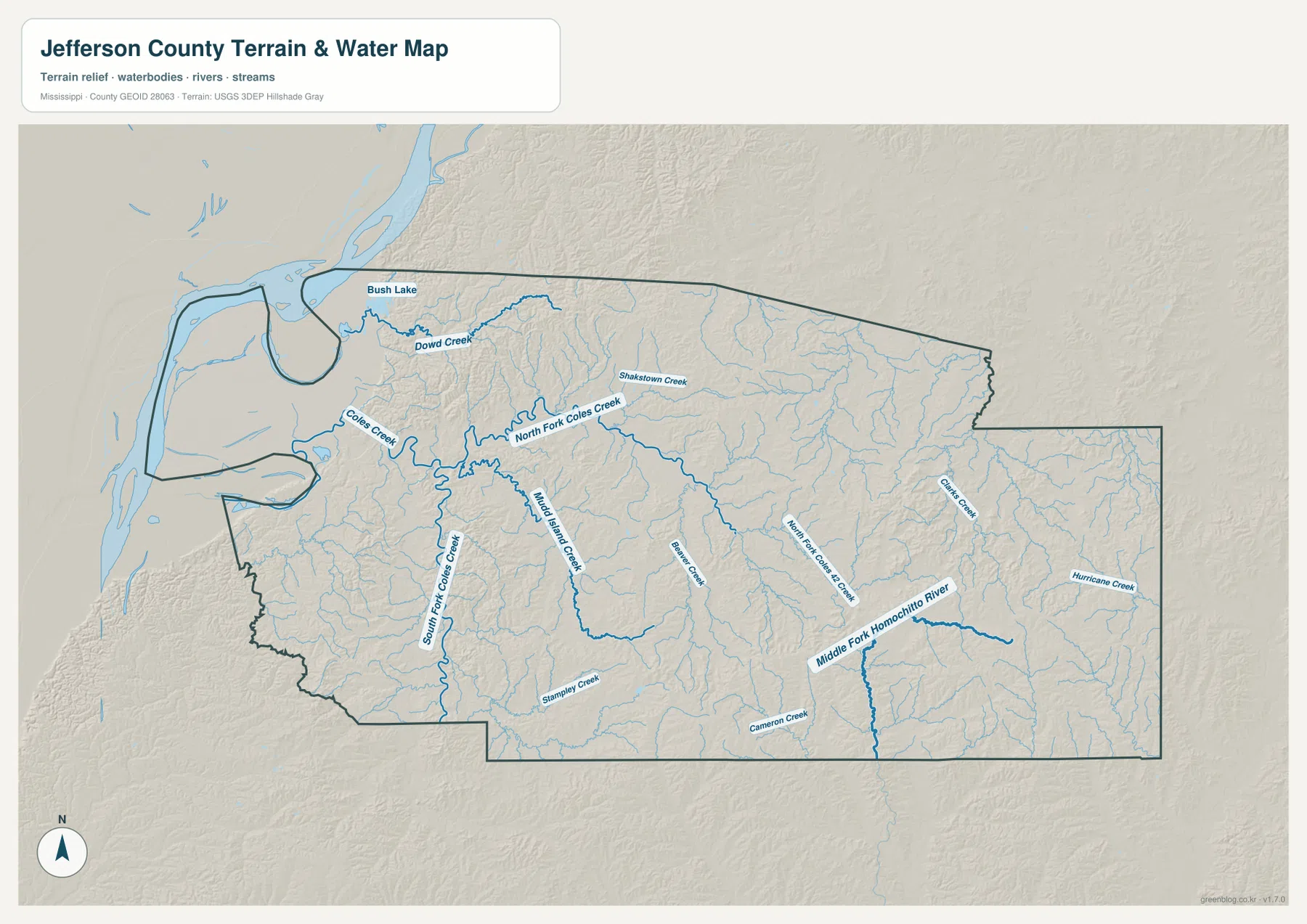
The water map shows a much denser network than the city layer. Bush Lake and Dowd Creek appear in the northwest, while Coles Creek, North Fork Coles Creek, and South Fork Coles Creek branch through the western and central part of the county. These named channels sit within many smaller tributaries, so the map is especially useful for seeing how valleys divide the uplands.
Farther east and south, Middle Branch Creek, Cameron Creek, Middle Fork Homochitto River, and Hurricane Creek provide additional reference lines. The map is intended to show the location of water features and terrain relationships; it is not a flood-risk map, parcel map, navigation chart, or statement about legal access.
A 7–162 m elevation range from west lowlands to eastern hills
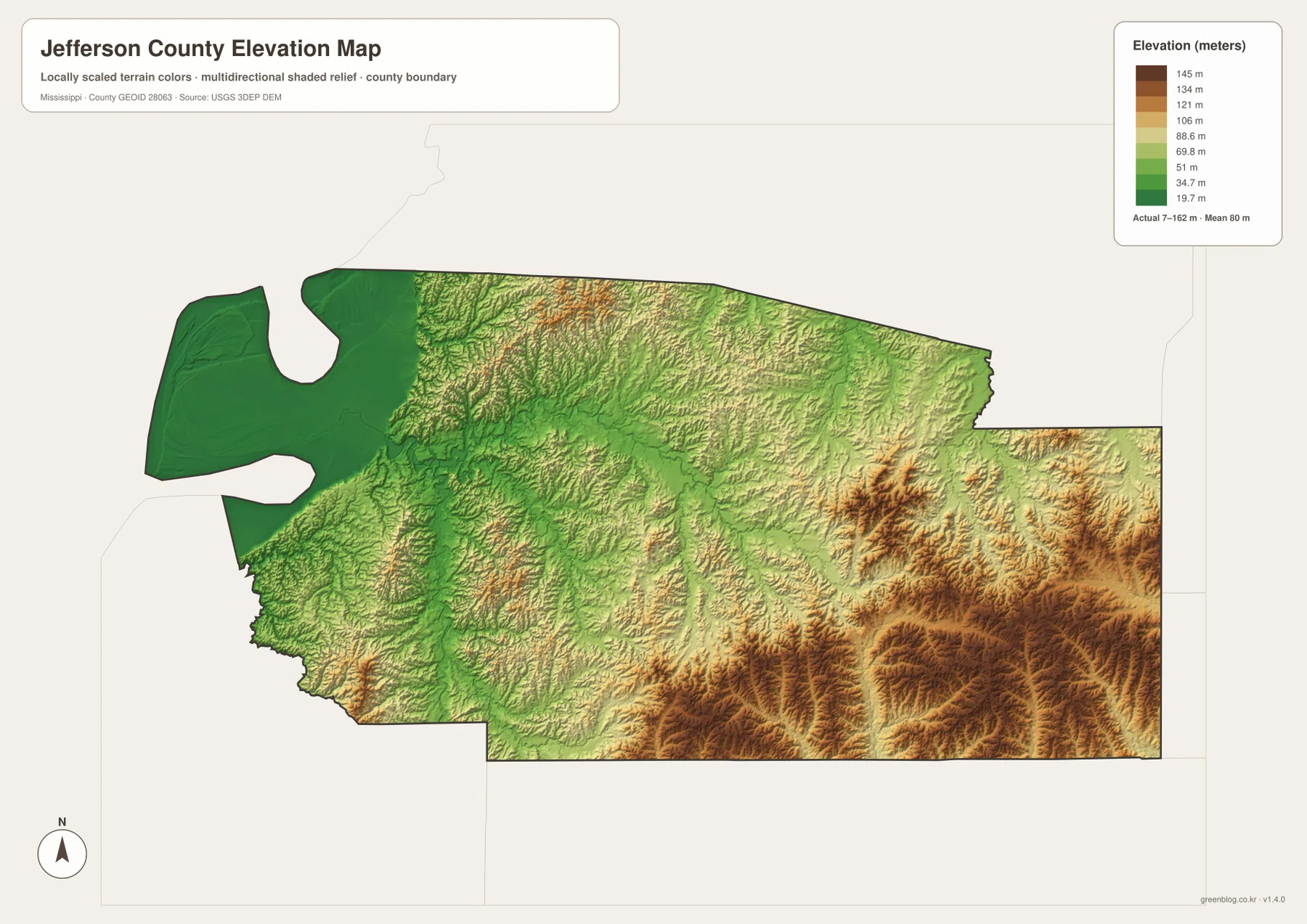
The elevation legend gives an actual range of about 7 to 162 meters and a mean near 80 meters. The lowest greens cover much of the western and northwestern side, consistent with the lower ground near the Mississippi River corridor. Moving toward the middle of the county, short ridges and narrow valleys create a more broken surface.
The eastern and southeastern half contains the broadest brown and tan areas, marking higher hills and stronger local relief. This contrast explains why the county’s road and drainage pattern looks different from one side to the other. The elevation surface is useful for county-scale orientation, but it should not be treated as survey-grade elevation for construction or engineering decisions.
Population and area numbers in map context
The existing county data in the package give a 2020 census population of 7,260 and a July 2025 estimate of 6,825. Because those figures use different reference dates, they are best treated as context rather than as a single like-for-like time series. They reinforce the visual impression of a large, lightly settled county where Fayette stands out more strongly than it would in a dense urban county.
- County seat: Fayette
- FIPS: 28063
- 2020 census population: 7,260
- July 2025 population estimate: 6,825
- 2025 Gazetteer area: 519.933 sq mi land and 7.331 sq mi water
- 2020 population divided by 2025 land area: about 14.0 residents per sq mi
That countywide density does not mean residents are evenly spread across Fayette, farm country, wooded uplands, and river-side lowlands. The maps show roads, settlement labels, and waterways concentrating in different places. Use the number for overall scale, then return to the maps for actual location relationships.
Which map is most useful for a Jefferson County question?
Use the county map first when the question is directional: for example, whether a location lies closer to US 61, MS 28, or the eastern routes. The city map is most useful for confirming Fayette’s role as the principal highlighted city. The water map becomes more useful when a place is described by a creek or low valley, while the elevation map is the clearest way to compare the lower western side with the hillier east.
For printing or reuse outside the browser, the JPG ZIP is preferable to saving the WebP previews individually. It keeps the same county, city, water, and elevation views together at higher resolution, which is more practical for a large slide, worksheet, poster, or local reference handout.
Frequently Asked Questions
Why is Fayette the main reference point on these maps?
Fayette is the county seat, appears near the center of the general road map, and is the only major city highlighted on the city-index map. That combination makes it the simplest starting point for explaining roads, waterways, and elevation elsewhere in the county.
Is western Jefferson County really lower than the eastern side?
Yes. The elevation map shows broad low green areas in the west and northwest, while higher tan and brown uplands become more common toward the east and southeast. The water map also shows many channels occupying the lower valleys between those ridges.
Can the water map be used to determine flood risk?
No. It is a geographic reference for named lakes, rivers, and creeks such as Bush Lake, Coles Creek, and Middle Fork Homochitto River. Flood risk, levee conditions, property restrictions, and emergency decisions require separate official hazard information.
Map File Information
Download the high-resolution JPG originals that match the WebP previews on this page. The ZIP keeps the county, city, water, and elevation maps together for printing, presentations, and offline reference.
- Included Files: County map, city map, water map, and elevation map
- File Type: Four high-resolution JPG files in one ZIP archive
- Intended Use: Printing, education, presentations, and map-based projects
Related Maps
Sources and References
- U.S. Census Bureau Jefferson County QuickFacts
- U.S. Census Bureau Gazetteer Files
- Mississippi Department of Transportation official highway map
- USGS National Hydrography
- USGS 3D Elevation Program
- Alcorn State University
Green Map creates custom-edited map images using open geographic data sources such as geoBoundaries, Natural Earth, OpenStreetMap, and government open data. These maps are edited visual materials, not raw data files, and are provided for education, documents, presentations, and graphic reference.