Watauga County is a High Country mountain county where Boone is the largest urban and administrative center, but not the only useful way to orient the map. Valle Crucis sits in a separate western valley, Beech Mountain and Seven Devils occupy the western and southwestern mountain edge, and Blowing Rock forms a distinct southeastern town and tourism direction. Roads and streams bend around ridges throughout the county, so straight-line distance alone does not explain how these places relate to one another.
The article begins with the general road-and-place map, then uses the city-connections graphic to compare Blowing Rock, Beech Mountain, and Seven Devils from Boone, and finally turns to the terrain-and-water map for New River headwaters, Watauga River, mountain creeks, and small lakes. The WebP previews are meant for quick browsing. A ZIP containing the three matching high-resolution A3 JPG files is available in the map file box below for printing, enlargement, or document use.
Table of Contents
Watauga County quick facts
- County seat and largest urban reference: Boone
- Visible place labels include Boone, Valle Crucis, Beech Mountain, Seven Devils, Foscoe, Blowing Rock, and Cove Creek
- Major road labels on the general map include 421, 321, 105, 194, 221, and 88
- City-connections values: Boone 20,032; Blowing Rock 992; Beech Mountain 987; Seven Devils 425
- Straight-line links from Boone: about 6 miles to Blowing Rock, 9 miles to Seven Devils, and 12 miles to Beech Mountain
- Named waterways include South Fork New River, Watauga River, Cove Creek, Meat Camp Creek, Howard Creek, Elk Creek, and Dutch Creek
The existing page identifies Boone as both the county seat and a university-centered town associated with Appalachian State University. It also treats Blowing Rock and Valle Crucis as distinct mountain settings and notes that Blue Ridge Parkway crosses Watauga County. Those source-derived points remain part of the background, while the detailed discussion below stays with roads, place labels, streams, and terrain that can be located in the supplied map package.
Boone university core versus mountain tourism
Boone dominates the central general map and contains labels for the Watauga County Courthouse and Watauga Medical Center. Routes 421 and 321 provide strong road references around the town, while route 105 heads southwest toward Valle Crucis and Foscoe. Boone therefore combines county administration, university-town context, and transportation in one valley, but the surrounding mountain communities do not simply continue as one continuous urban surface.
Valle Crucis lies west of Boone in a separate valley, with Foscoe and Seven Devils farther south and southwest. Beech Mountain is still farther west near the county edge. Keeping those places distinct makes the western half easier to understand because the road lines and stream valleys do not radiate from Boone in a simple suburban pattern.
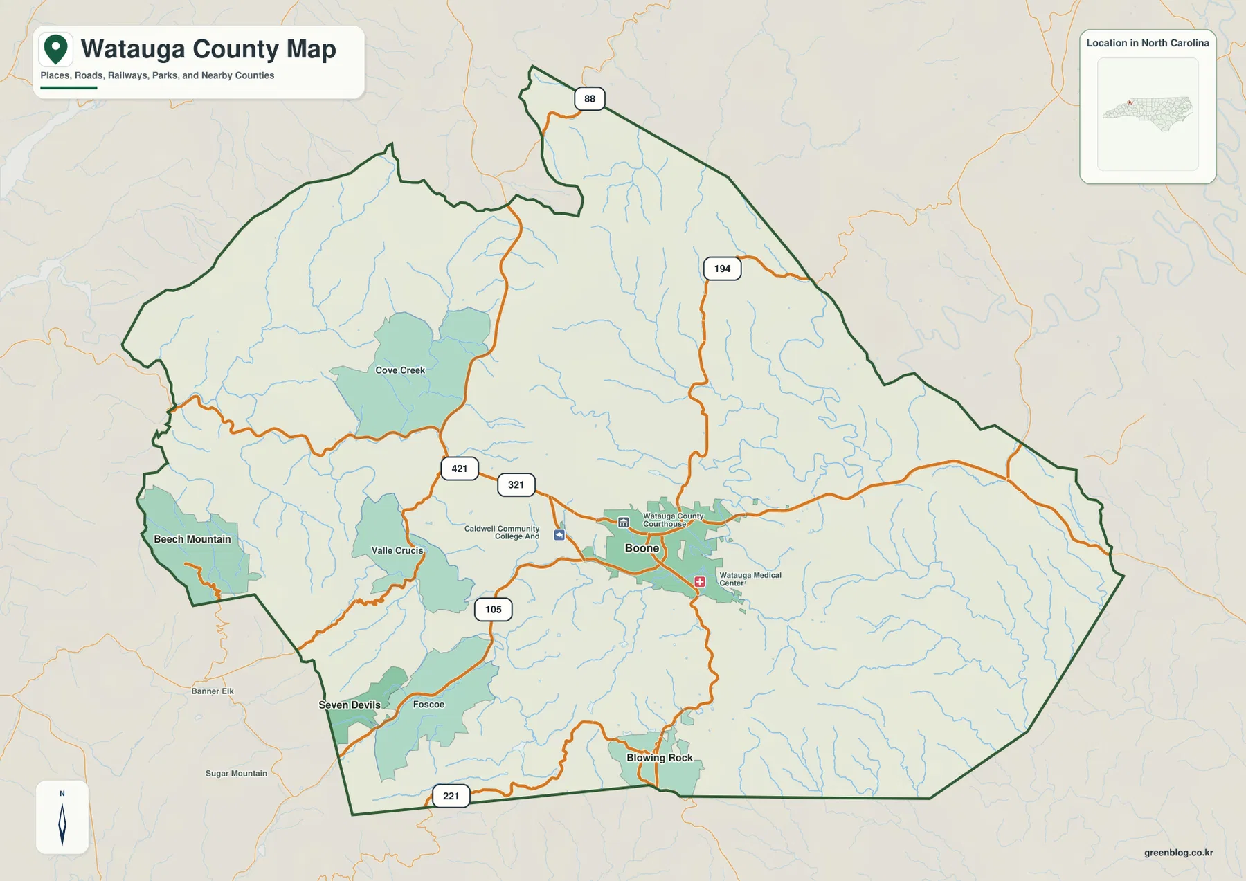
Blowing Rock provides the clearest southeastern counterpoint to Boone. It is marked as a separate developed area close to the southern boundary, with route 221 providing one road reference along that side. The existing page’s tourism framing fits the map because Blowing Rock occupies a different mountain corridor rather than functioning as another neighborhood inside the Boone urban area.
North of Boone, route 194 climbs into sparsely settled mountain terrain and route 88 appears near the narrow northern extension of the county. This part of the map contains far more streams and ridges than urban shading. Travel direction is therefore easier to understand when road corridors are read together with the valleys they follow.
Blue Ridge Parkway and New River headwaters
South Fork New River is the strongest named water reference on the eastern half of the terrain map. It curves through the central-eastern mountains and receives many smaller tributaries. Reading the river with Boone and the surrounding relief shows why municipal boundaries are less useful than valleys for understanding several parts of the county.
Meat Camp Creek and Howard Creek appear north of Boone, while Cove Creek occupies a long northwestern valley. These channels divide the high terrain into separate corridors. The terrain shading also makes clear why roads bend so often: many routes follow lower valleys instead of crossing every ridge directly.
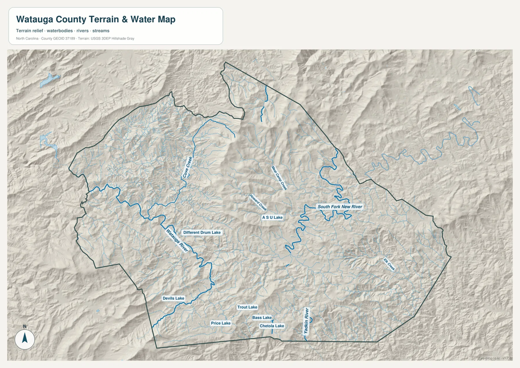
Watauga River provides a separate major water reference on the western and southwestern side. Different Drum Lake and Devils Lake appear near that broader drainage, while Price Lake, Trout Lake, Bass Lake, and Chetola Lake provide smaller southern references. These are local mountain water bodies rather than county-scale reservoirs, but they are useful for locating individual valleys near the Blowing Rock side.
The existing page says that Blue Ridge Parkway crosses Watauga County, although the parkway name is not printed prominently on this water preview. That distinction matters. The parkway can remain part of the county’s source-backed geographic background, while exact map descriptions should rely on the roads, towns, rivers, creeks, and lakes that are actually labeled in the supplied images.
Blowing Rock and Valle Crucis occupy different settings
The city-connections graphic uses Boone as the hub and prints four values in its lower panel: Boone 20,032, Blowing Rock 992, Beech Mountain 987, and Seven Devils 425. These figures belong to the supplied image and are not being replaced here with an independently updated population series.
The same graphic places Blowing Rock about 6 straight-line miles from Boone, Seven Devils about 9 miles away, and Beech Mountain about 12 miles away. Those connectors do not represent road mileage or travel time. Blowing Rock lies southeast, Seven Devils southwest, and Beech Mountain west of Boone, so actual travel depends on which mountain roads and valleys connect the places.
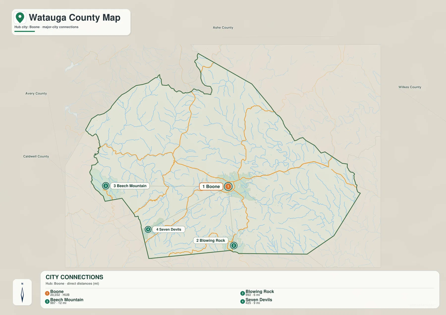
Valle Crucis is not part of the four-place ranking, yet it is an important label on the general map between Boone and the western mountain communities. That is a useful reminder that Watauga County cannot be reduced to a city ranking. Boone explains administration and university life, Blowing Rock a southeastern tourism corridor, Beech Mountain and Seven Devils western high-elevation settlements, and Valle Crucis a separate valley setting.
The outer city map labels Ashe, Avery, Caldwell, and Wilkes counties. These names provide regional orientation rather than legal distance or driving information. The county outline and the internal place markers remain the better references for deciding where Watauga County’s communities sit within the High Country.
Comparing elevation and functional zones
The terrain map is rugged almost everywhere. Tight ridges and narrow valleys fill the northwest and west, while the Boone area still looks like a mountain basin rather than a broad plain. The Blowing Rock side also contains strongly shaded relief and closely spaced stream valleys, showing that settlement location is closely tied to the shape of the terrain.
A useful reading sequence starts with Boone, expands west to Valle Crucis and Beech Mountain, southwest to Seven Devils, and southeast to Blowing Rock, then adds South Fork New River and Watauga River as physical references. This prevents administrative role, tourism function, and mountain geography from being flattened into one center-and-outskirts description.
The download archive contains three high-resolution A3 JPG files matching the Watauga County general map, city-connections map, and terrain-and-water map. The WebP previews keep the page easy to browse, while the JPG originals retain more detail for printing, enlargement, and document placement, especially around the small creek labels and rugged relief.
For Watauga County, these maps are intended for broad geographic orientation. Survey-grade elevation, legal boundaries, flood determinations, and other technical decisions should rely on the relevant official Census, USGS, county, or other authoritative source data.
Frequently Asked Questions
Why use New River headwaters as a physical frame for Watauga County?
South Fork New River provides a major physical reference east and northeast of Boone, where mountain valleys matter more than a simple town-centered pattern. It helps connect the settlement map to the actual ridge-and-stream landscape without treating every outer area as an extension of Boone.
How does Blowing Rock broaden the map beyond the administrative center?
Boone explains county administration and the university-centered urban area, while Blowing Rock marks a separate southeastern tourism and mountain corridor. Keeping both places visible shows that the county contains different local functions and travel directions rather than one urban center with uniform outskirts.
Map File Information
The ZIP contains three high-resolution A3 JPG files matching the Watauga County general map, city-connections map, and terrain-and-water map shown on this page.
- Included Files: Use only the versions confirmed in the article and supplied images
- File Type: Use the confirmed download contents
- Intended Use: Printing, education, presentations, and map-based projects
Related Maps
- Across the Rowan County North Carolina Map
- Across the Surry County North Carolina Map
- Alamance County Map
Sources
- Watauga County – History
- U.S. Census Bureau – TIGER/Line Shapefiles
- USGS – National Hydrography
- USGS – 3D Elevation Program
The county history link provides local background, while Census and USGS links support boundary, hydrography, and terrain reference checks. The city values, straight-line distances, road labels, South Fork New River, Watauga River, named creeks, and small lakes described above are grounded in the supplied Watauga County map package.
Green Map creates custom-edited map images using open geographic data sources such as geoBoundaries, Natural Earth, OpenStreetMap, and government open data.
These maps are edited visual materials, not raw data files, and are provided for education, documents, presentations, and graphic reference.