Washington County sits in North Carolina’s northeastern Inner Banks, where the settlement pattern stretches from Plymouth in the west through Roper to Creswell in the east. Plymouth is the county seat and the largest marked community, but the map becomes much more accurate when Roper and Creswell remain separate reference points. North of the county lies Albemarle Sound, while the southeast is dominated by Phelps Lake and a dense network of streams, canals, and drainage lines. Water and lowland geography therefore explain much of the county that town names alone cannot.
The page moves from the general road-and-place map to a Plymouth-centered city-connections view and then to the terrain-and-water map. The WebP previews are meant for quick browsing, while the map file box below provides three matching high-resolution A3 JPG files in one ZIP. The larger originals are especially helpful when narrow canals, small creek labels, or the detailed shoreline of Phelps Lake and Albemarle Sound need to be enlarged or printed.
Table of Contents
Washington County quick facts
- County seat and city-map hub: Plymouth
- City-connections values printed on the supplied map: Plymouth 3,250; Roper 384; Creswell 217
- Straight-line links from Plymouth: about 8 miles to Roper and about 20 miles to Creswell
- Major road labels visible on the general map include 32, 64, 94, 308, 99, and 45
- Large water references printed on the terrain map: Albemarle Sound, Phelps Lake, and Pungo Lake
- Named waterways and canals include Scuppernong River, Kendrick Creek, Conaby Creek, Deep Creek, Rattling Creek, Mountain Canal, and Thirty Foot Canal
The existing page describes Plymouth as the Roanoke River county seat and uses Roper and Creswell to explain the eastern countryside. It also places Roanoke River, Cashie River, and Albemarle Sound within the county’s broader Inner Banks water-transport and wetland setting. This rewrite keeps that context but bases the detailed map discussion on labels visible in the supplied package: Plymouth, Roper, Creswell, Albemarle Sound, Scuppernong River, Phelps Lake, roads, creeks, and canals.
Plymouth riverfront versus eastern countryside
Plymouth occupies the western side and has the strongest concentration of developed shading and road lines on the general map. Route 32 leaves the town toward Roper, while route 308 provides another northwestern reference. Washington County Emergency Medical is also labeled between Plymouth and Roper, reinforcing the western side as the county’s clearest administrative and service center.
Roper sits farther east in the north-central interior. Route 64 passes near the community and continues toward Creswell, while small streams and long drainage lines become much more visible around the surrounding rural land. Keeping Roper as its own reference prevents the large agricultural and wetland interior from being reduced to the outskirts of Plymouth.
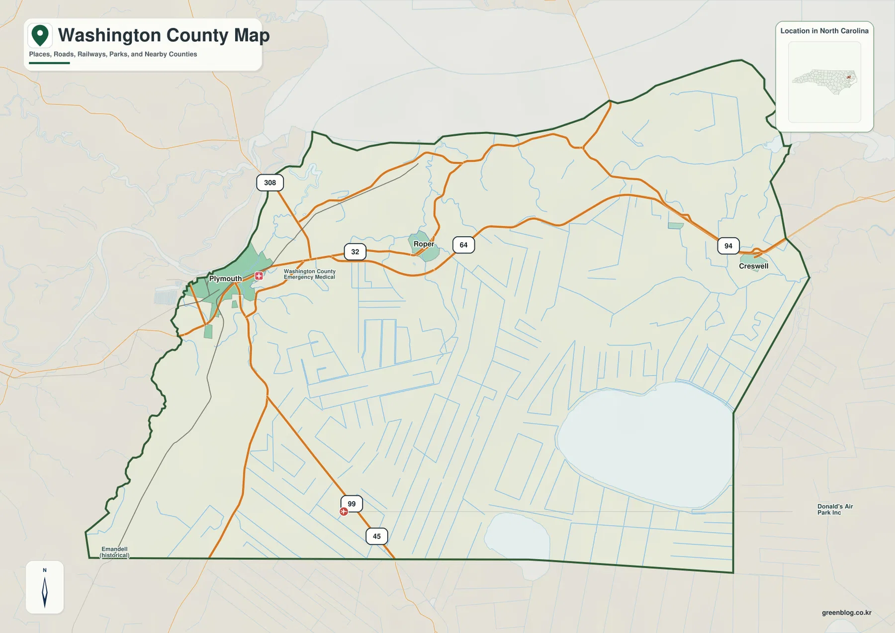
Creswell lies still farther east near route 94. The settlement footprint is small, and the surrounding map quickly transitions into open rural land, canals, and larger water features. Plymouth, Roper, and Creswell therefore provide a useful west-to-east sequence without implying that they form one continuous urban corridor.
Routes 99 and 45 extend into the southern part of the county, where settlement labels become sparse. Straight drainage features stand out more than town streets in this section. The road map alone already suggests that Washington County’s southern half is shaped more by lowland agriculture, wetlands, and water management than by urban development.
Roanoke, Cashie, and Albemarle water connections
Albemarle Sound is the broadest northern water feature on the terrain map. The county’s upper boundary runs along this large estuarine water body, with Batchelor Bay labeled toward the northwest and Bull Bay toward the northeast. Read together with the existing page’s Roanoke River context around Plymouth, the sound explains why the county’s northern orientation is strongly tied to water rather than only to roads.
Scuppernong River is the clearest named river in the northeastern interior, with Deep Creek and Rattling Creek appearing farther north and east. It provides a direct physical reference for the Creswell side of the county. Cashie River is part of the existing page’s regional water-connection background, but its name is not printed on this preview, so this rewrite does not pretend that the river is directly mapped here.
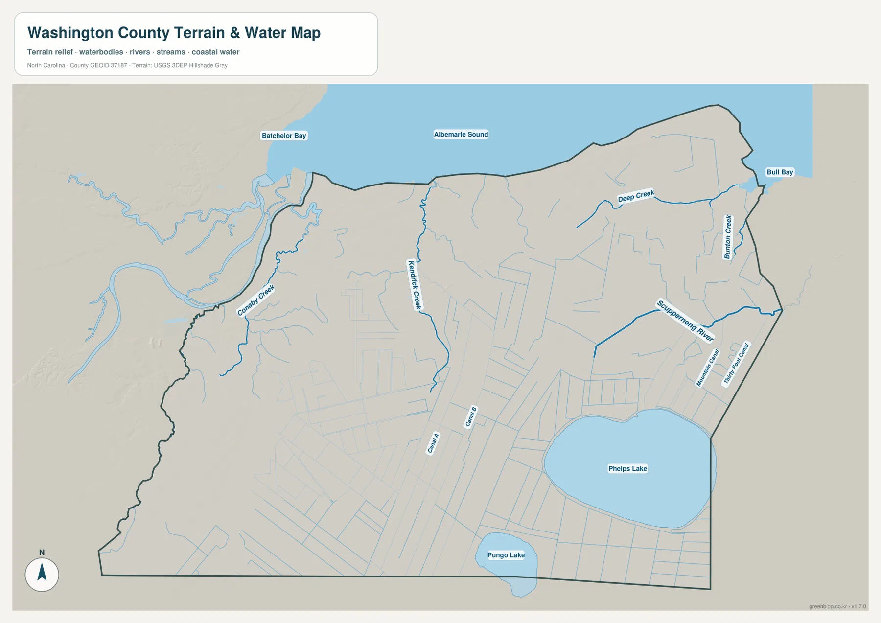
Kendrick Creek runs through the north-central interior, while Conaby Creek provides a separate western water reference. Across the southern half, Mountain Canal, Thirty Foot Canal, and many straight drainage lines cut through broad low terrain. The combination of natural creeks and straight canals is one of the clearest visual clues that the county’s landscape is low, wet, and heavily organized around drainage.
Phelps Lake dominates the southeastern interior, with Pungo Lake farther south near the county edge. These lakes are better treated as physical anchors for the outer county than as extensions of the Plymouth settlement story. Around Phelps Lake in particular, shoreline and drainage features occupy much more visual space than roads or towns.
Water transport behind Inner Banks geography
The city-connections map uses Plymouth as its hub and prints three settlement values in the lower panel: Plymouth 3,250, Roper 384, and Creswell 217. These numbers come from this Washington County graphic and are not being replaced here with a different population series.
The same graphic marks Roper about 8 straight-line miles from Plymouth and Creswell about 20 miles away. Those connectors are not road mileage or travel time. The general map shows routes 32, 64, and 94 bending and branching through the lowland landscape, so actual travel should be checked against the road network rather than estimated from the straight connector lines.
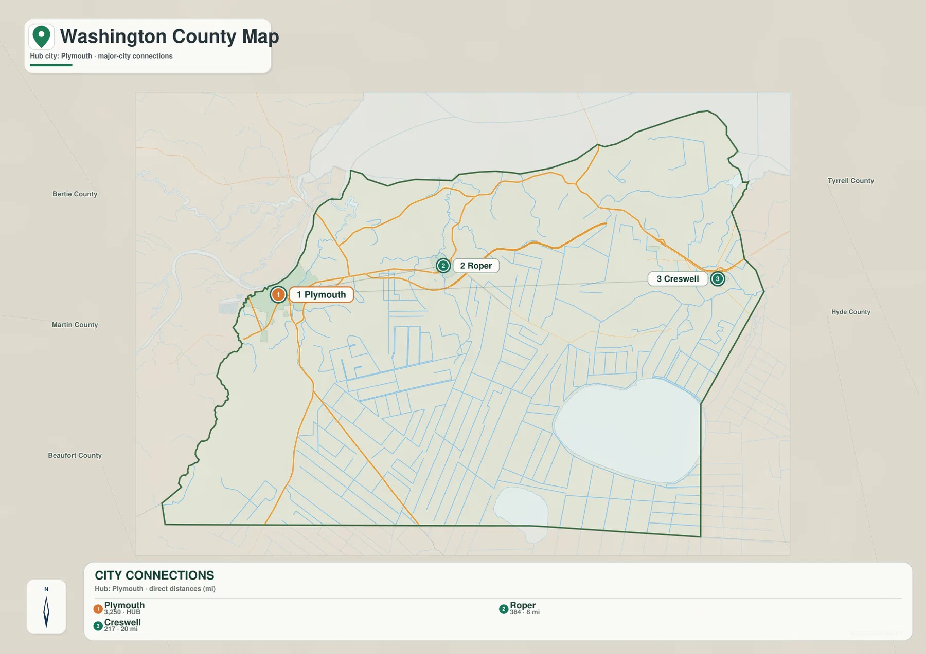
The outer labels identify Bertie, Martin, Beaufort, Tyrrell, and Hyde counties. They help place Washington County within northeastern North Carolina and the Albemarle-Pamlico Inner Banks region, but they are not measurements of legal distance or travel time. The county outline and the three internal settlement markers remain the primary references.
The current page’s emphasis on river transport, agriculture, and wetlands fits the supplied maps. Plymouth explains the western riverfront and administrative center, Roper and Creswell extend the settlement pattern eastward, and the broad spaces between and south of them are organized more by creeks, canals, lakes, and lowland drainage than by additional town centers.
Separating river, wetland, and rural layers
A practical way to read Washington County is to start with Plymouth for administration and western settlement, use Roper as the central rural reference and Creswell for the east, then add Albemarle Sound, Scuppernong River, and Phelps Lake as separate physical anchors. This keeps settlement and water geography distinct while showing how they interact within the same lowland county.
The general map is the best choice when road numbers and place names matter. The city-connections view is useful for comparing the Plymouth-Roper-Creswell direction and the 8- and 20-mile straight-line links. For Albemarle Sound, Scuppernong River, Phelps Lake, Kendrick Creek, and the canal network, the terrain-and-water map carries far more useful detail.
The download archive contains three high-resolution A3 JPG files matching the Washington County general map, city-connections map, and terrain-and-water map. For close inspection, the JPG originals retain the small creek and canal labels more clearly than the lighter WebP previews.
For Washington County, these maps are intended for broad geographic orientation. For Washington County, legal boundaries, flood or navigation decisions, survey work, water depth, and engineering-grade elevation checks should be made with the relevant official source data rather than this simplified map set.
Frequently Asked Questions
How does Roanoke River sharpen the contrast between the county center and its surroundings?
Roanoke River provides the western water context around Plymouth, while Roper and Creswell extend the settlement pattern eastward. Keeping those references separate makes it easier to see the difference between the western riverfront center and the lowland rural interior.
What part of the county is easier to understand through Roper?
Roper is most useful for the middle of the county between Plymouth and Creswell. It adds a clear settlement reference along route 64 where long drainage lines and open lowland would otherwise be described only as the outer area beyond Plymouth.
Map File Information
The ZIP contains three high-resolution A3 JPG files matching the Washington County general map, city-connections map, and terrain-and-water map shown on this page.
- Included Files: Three high-resolution A3 JPG maps: general county, city connections, and terrain-and-water
- File Type: JPG files in one ZIP archive
- Intended Use: Printing, education, presentations, and map-based projects
Related Maps
- Across the Rowan County North Carolina Map
- Across the Surry County North Carolina Map
- Alamance County Map
Sources
- Washington County – Economic Development
- U.S. Census Bureau – TIGER/Line Shapefiles
- USGS – National Hydrography
- USGS – 3D Elevation Program
The county source provides local background, while Census and USGS links support boundary, road, hydrography, and elevation reference checks. The settlement values, connector distances, road labels, Albemarle Sound, Phelps Lake, Scuppernong River, creeks, and canal names described above are grounded in the supplied Washington County map package.
Green Map creates custom-edited map images using open geographic data sources such as geoBoundaries, Natural Earth, OpenStreetMap, and government open data.
These maps are edited visual materials, not raw data files, and are provided for education, documents, presentations, and graphic reference.