Warren County is a rural Piedmont county where small settlements and northern water bodies provide more useful orientation than a large-city hierarchy. Warrenton is the county seat, but Norlina and Macon give the northern and northeastern interior separate reference points. Lake Gaston then changes the character of the northeastern edge, creating a water-oriented area that should not be treated as simply another part of inland Warrenton.
The page combines a general road-and-place map, a city-connections view centered on Norlina, and a terrain-and-water map built around Lake Gaston and the county’s creek network. The WebP previews are convenient for quick browsing, while the map file box below provides the matching high-resolution A3 JPG files in one ZIP. The larger originals are especially useful when small creek names, pond labels, or road shields need to be enlarged or printed.
Table of Contents
Warren County quick facts
- County seat: Warrenton
- Hub on the supplied city-connections map: Norlina 1,087
- City-connections labels: Warrenton 772 at about 4 miles; Macon 66 at about 6 miles
- Major road references visible on the general map include I-85, US 1, US 158, US 401, NC 58, NC 43, and NC 903
- Large water feature labeled directly on the terrain map: Lake Gaston
- Named smaller waters include Smith Creek, Hamme Creek, Owen Creek, Walker Creek, Bells Creek, Little Fishing Creek, Reedy Creek, Fishing Creek, Shocco Creek, Peetes Pond, Hammes Mill Pond, Ryders Pond, and Largo Lake
The existing Warren County page and county planning material also identify Kerr Lake at the northwestern edge and describe the county as spanning Roanoke and Tar-Pamlico drainage areas. Those points remain useful background, but this rewrite distinguishes them from features printed directly on the supplied preview. The terrain image clearly labels Lake Gaston and numerous creeks and ponds; it does not draw a new basin boundary or provide technical watershed measurements.
Inland Warrenton versus northern lakes
Warrenton appears near the north-central interior and remains the administrative anchor. NC 58 runs through the Warrenton-Norlina direction, while US 158 crosses the northern part of the county from the Norlina side toward the east. I-85 stays near the western edge and US 1 provides another strong reference around Norlina. These routes make the northern interior easier to locate before the lake districts are considered.
Norlina sits north of Warrenton and is used as the hub on the city-connections graphic. That choice is useful because administrative importance and map orientation do not have to be the same thing. From Norlina, Warrenton lies to the south and Macon to the east, so the three places describe different parts of the rural north rather than a single center-and-suburb pattern.
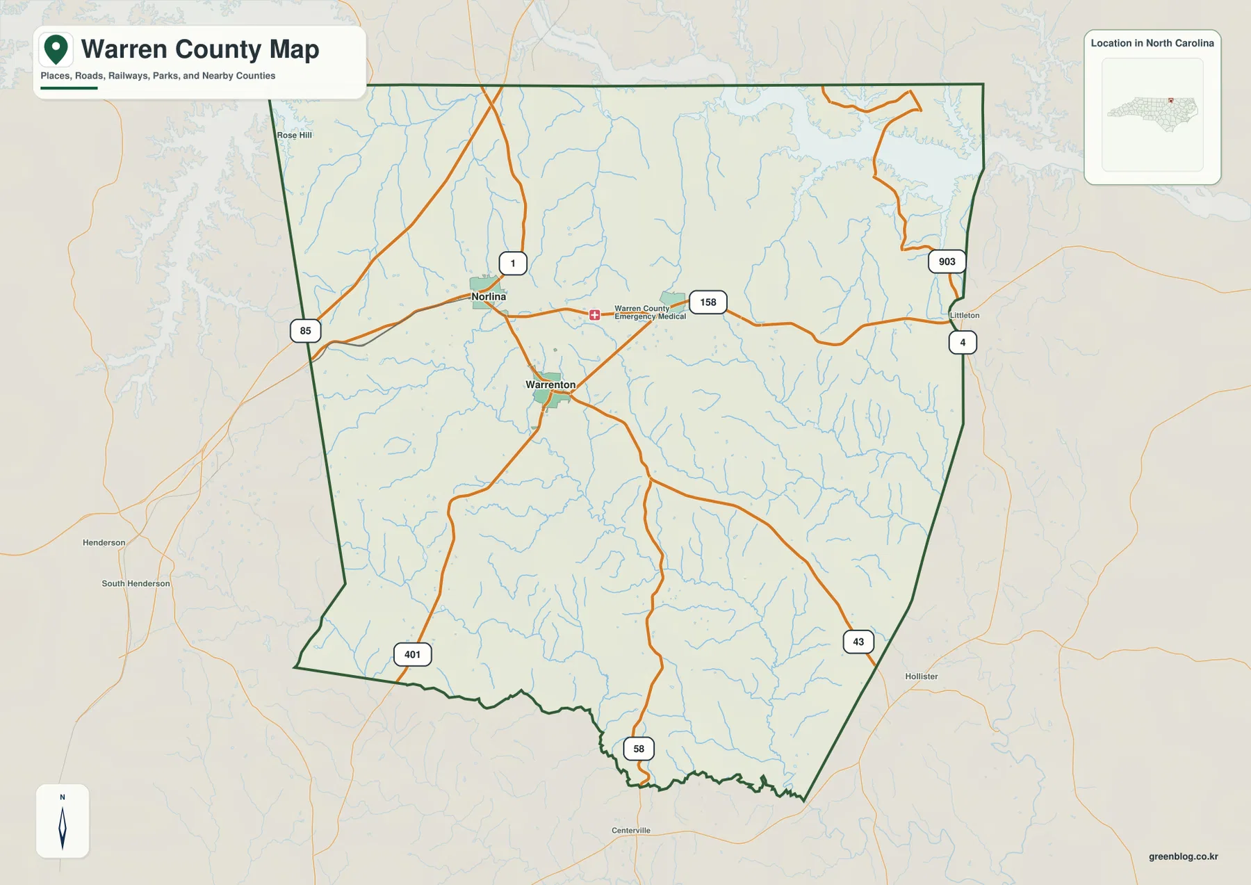
US 401 provides a southwestern reference, while NC 43 reaches toward the southeastern edge. Littleton appears just outside the eastern side as regional context, with NC 903 and route 4 visible nearby. Those outer labels are useful for direction, but they should not be mistaken for internal Warren County settlement points.
The road map therefore shows a county whose administrative center and northern travel references are related but not identical. Warrenton organizes the interior, Norlina helps explain the north, and Macon extends the settlement pattern eastward toward the lake side. As the map approaches Lake Gaston, shoreline and stream valleys become more important than town size.
Lake Gaston, Kerr Lake, and two basins
Lake Gaston is the strongest water feature printed directly on the terrain map. Its irregular shoreline reaches into the northeastern edge of Warren County, with narrow arms following former stream valleys. That shape explains why the county’s northeastern boundary looks far more complicated on the water map than on a simple town-and-road view.
South and west of the lake, Walker Creek, Bells Creek, and Little Fishing Creek occupy separate valleys. Reedy Creek crosses the central interior, while Owen Creek and Fishing Creek help organize the western and southwestern sections. The useful pattern is not a checklist of stream names but a transition from a large reservoir shoreline in the northeast to a web of smaller creek valleys across the rural interior.
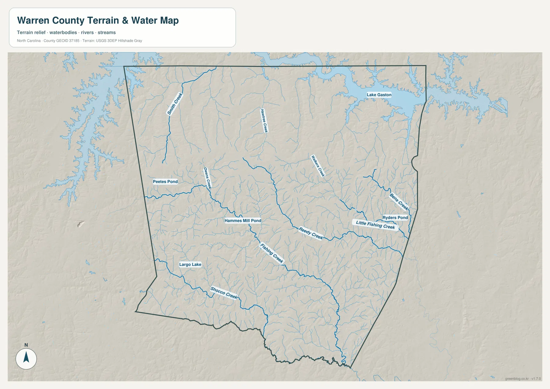
Smith Creek and Hamme Creek provide additional northern references, and Shocco Creek follows part of the southern area. Peetes Pond, Hammes Mill Pond, Ryders Pond, and Largo Lake add smaller local anchors. These water bodies are not comparable to Lake Gaston in scale; they are better used to locate individual rural sections and creek valleys.
The county planning material adds a broader frame by identifying Kerr Lake along the northwest edge and describing Warren County as divided between Roanoke and Tar-Pamlico drainage areas. Because those basin boundaries and the Kerr Lake label are not drawn explicitly on the supplied terrain preview, this article treats them as source background rather than as features newly inferred from the image.
Small settlements across a rural county
The city-connections map uses Norlina as its hub and prints three values in the lower panel. Norlina is first at 1,087, Warrenton second at 772, and Macon third at 66. These are values shown on the supplied graphic; this article does not replace them with a separate current-population series.
The same image marks Warrenton about 4 straight-line miles from Norlina and Macon about 6 miles away. Those lines are not driving routes or road mileage. The general map shows roads bending and branching through the county, so actual travel should be checked against the road network rather than estimated from the connector lines.
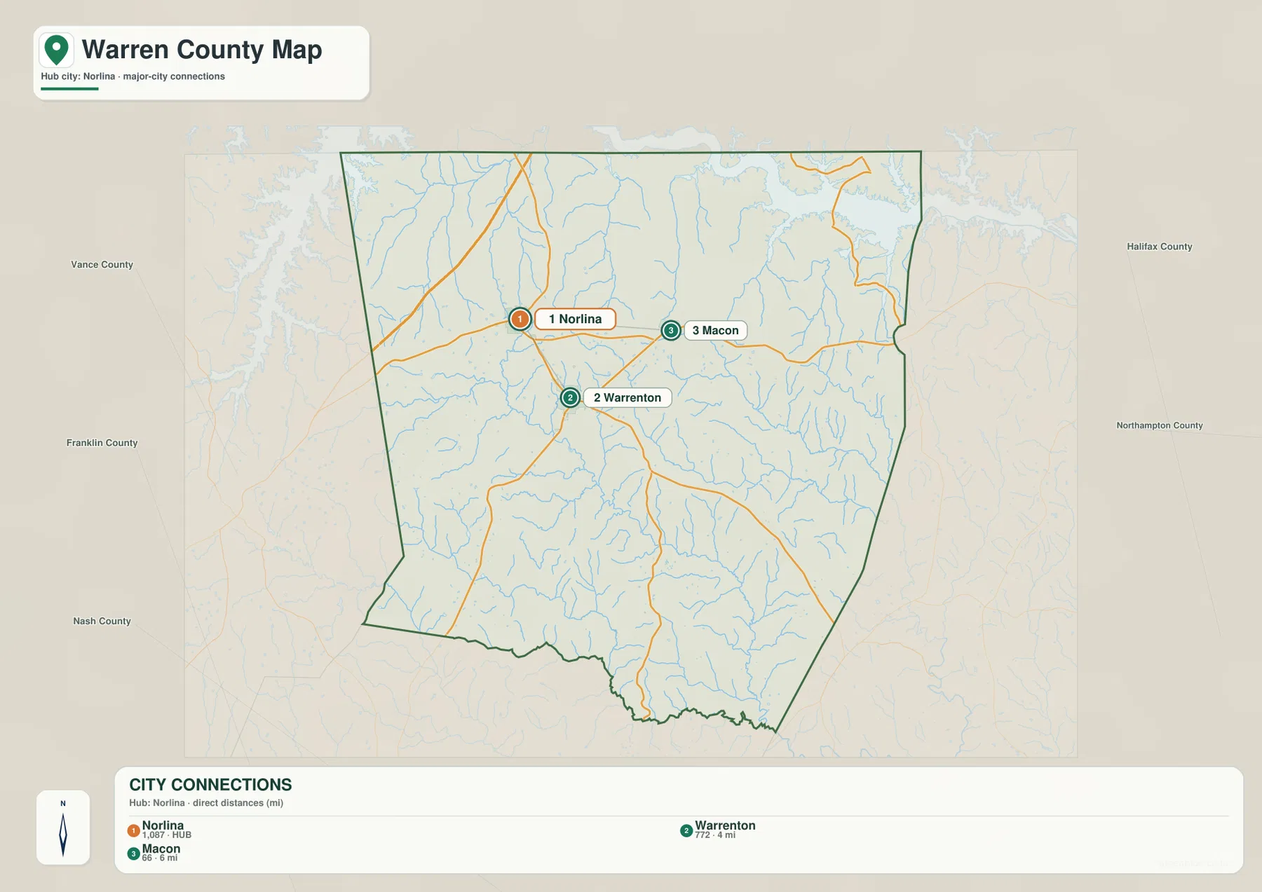
Warrenton’s role is administrative, Norlina provides a northern road-and-settlement reference, and Macon represents a smaller northeastern rural point. Ranking alone would make Macon look unimportant, but location gives it a useful role between the inland settlements and the Lake Gaston side. That is typical of a low-density county where small communities help divide a wide rural area.
The city map also shows Vance, Franklin, Nash, Halifax, and Northampton counties outside Warren County. Those labels provide regional orientation only. They are not measurements of legal distance or travel time, and the Warren County boundary remains the main reference for deciding which marked places belong inside the county.
Separating lake, farm, and town context
A practical reading order starts with Warrenton for county administration, then uses Norlina and Macon to separate the northern interior before moving to Lake Gaston and the creek network. This keeps settlement references and physical references distinct without pretending they are unrelated. The towns explain where people and roads cluster; the lake and streams explain why the rural landscape is divided into different valleys and shoreline areas.
The general map is best when road numbers and place names matter. The city-connections view is useful for the Norlina-Warrenton-Macon comparison and the 4- and 6-mile straight-line links. For Lake Gaston, Reedy Creek, Fishing Creek, Shocco Creek, and smaller ponds, the terrain-and-water map carries far more detail. Switching maps by question is more effective than expecting one image to serve every purpose.
The county’s established rural and agricultural context also fits this approach. Inland areas are most easily described through small towns, roads, and creek valleys, while the northern lake districts need shoreline and water references. Treating Lake Gaston or Kerr Lake as if it represented the whole county would be just as misleading as describing every outer area as part of Warrenton.
The download archive contains three high-resolution A3 JPG files matching the Warren County general map, city-connections map, and terrain-and-water map. The WebP previews keep the page quick to browse, while the JPG originals preserve more detail for enlargement, printing, and document placement, especially around small water labels and the Lake Gaston shoreline.
These maps are intended for general geographic reference. Legal boundaries, surveying, flood determinations, navigation, water depth, and engineering-grade elevation work should rely on the relevant official Census, USGS, county, or other authoritative source data.
Frequently Asked Questions
What would be harder to understand if Lake Gaston were omitted?
Without Lake Gaston, the northeastern edge would look like an ordinary rural extension of Warrenton and Norlina. The reservoir explains the complex shoreline, the nearby creek valleys, and why the northern water-oriented area needs a different reference from the inland settlements.
Why should a reader compare Norlina and Warrenton rather than rank them?
Warrenton is the county seat, while Norlina is the hub chosen by the city-connections map and a stronger northern road reference. Comparing their locations is more useful than treating one as simply superior to the other because each helps explain a different part of Warren County.
Map File Information
The ZIP contains three high-resolution A3 JPG files matching the Warren County general map, city-connections map, and terrain-and-water map shown on this page.
- Included Files: General map, city-connections map, and terrain-and-water map
- File Type: Three high-resolution A3 JPG files in one ZIP archive
- Intended Use: Printing, education, presentations, and map-based projects
Related Maps
- Across the Rowan County North Carolina Map
- Across the Surry County North Carolina Map
- Alamance County Map
Sources
- Warren County – Parks and Recreation Master Plan
- U.S. Census Bureau – TIGER/Line Shapefiles
- USGS – National Hydrography
- USGS – 3D Elevation Program
The Warren County planning source provides the lake, recreation, and rural background used here, while Census and USGS links provide official boundary, hydrography, and terrain-data references. Road labels, city-connection values, Lake Gaston, and the named creeks and ponds described above come from the supplied Warren County map package.
Green Map creates custom-edited map images using open geographic data sources such as geoBoundaries, Natural Earth, OpenStreetMap, and government open data.
These maps are edited visual materials, not raw data files, and are provided for education, documents, presentations, and graphic reference.