Rowan County sits in North Carolina’s central Piedmont, where Salisbury provides the clearest urban reference but does not explain the whole county. Spencer and East Spencer sit just to the north, while China Grove and Landis form a separate southern group before the map reaches Kannapolis at the county line. To the east, the Yadkin River and the broad High Rock Lake area create a water-dominated edge that looks very different from the road-centered Salisbury corridor.
This page provides three views of Rowan County: a general map with boundaries, roads, and place labels; a ranked city-distribution map for six major communities; and a terrain-and-water map showing the Yadkin River system, creeks, lakes, and shaded relief. You can download the matching high-resolution A3 JPG files together in one ZIP from the map file box below. The WebP images in the article are quick previews, while the JPG files are better for printing, enlarged inspection, and document use.
Table of Contents
Map File Information
The ZIP contains three high-resolution A3 JPG files matching the Rowan County general map, city-distribution map, and terrain-and-water map shown on this page.
- Included Files: Three high-resolution A3 JPG maps matching the general, city-distribution, and terrain-and-water views on this page
- File Type: JPG files supplied together in one ZIP archive
- Intended Use: Printing, education, presentations, and map-based projects
How the Three Rowan County Maps Differ
The ranked city map shows one large center and several smaller communities in different directions
The supplied City Index ranks Salisbury first with 35,825, China Grove second with 4,530, Landis third with 3,765, Spencer fourth with 3,749, Granite Quarry fifth with 3,043, and Rockwell sixth with 2,782. These are the values printed on this specific map image; this article does not treat them as independently updated population estimates.
The locations are more useful than the ranking alone. Salisbury stands in the middle as the largest urban reference, Spencer sits just north, and China Grove plus Landis form a southern pair. Granite Quarry lies southeast of Salisbury, while Rockwell is farther southeast again. Reading those positions separately makes the county much easier to understand than simply listing the six names by size.
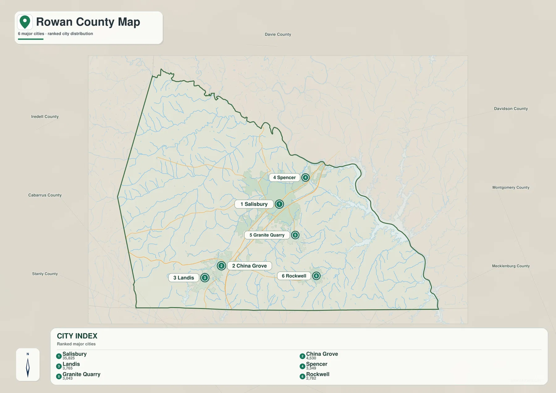
County names around the outside include Davie, Iredell, Cabarrus, Stanly, Davidson, Montgomery, and Mecklenburg. They help position Rowan County within the central Piedmont, but the city graphic is not a legal adjacency survey. The county outline should be checked first, with the external names used only for regional orientation.
The city-distribution map does not show driving distance or connector mileage. Its numbered markers indicate rank and location rather than travel time. Actual routes between Salisbury and China Grove, or between Spencer and Rockwell, should be checked on the general road map instead of estimated from the spacing of the city markers.
The Yadkin system explains the eastern and northern edges better than the road map alone
The terrain-and-water map shifts attention from roads to drainage. Yadkin River follows the eastern side of the county, and the existing county material identifies the High Rock Lake system as a major physical reference on the east. Seen together with the general map, the broad water area explains why the county boundary bends sharply in this direction instead of looking like a simple land-based line.
South Yadkin River is labeled across the northern portion of the map. Fourth Creek and Third Creek appear below it, while Beaverdam Creek and Withrow Creek provide western references. North Second Creek runs through the north-central interior. These smaller waterways reveal a much more detailed landscape between Cleveland and Salisbury than the road map suggests.
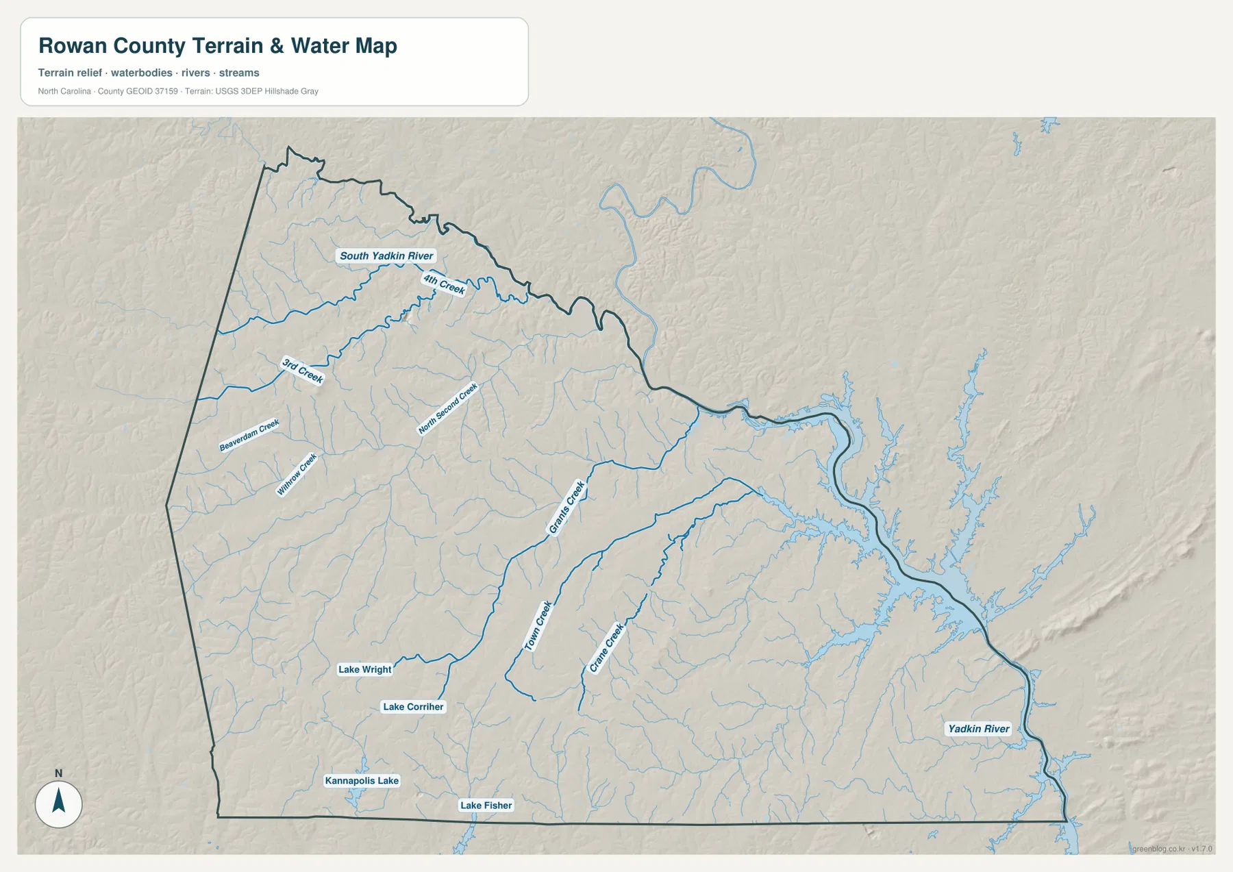
Grants Creek runs through the central-eastern portion, with Town Creek and Crane Creek farther south. Lake Wright and Lake Corriher are labeled in the southwest, while Kannapolis Lake and Lake Fisher appear near the southern edge. No single small lake defines the county, but together they show that surface water is distributed well beyond the large Yadkin-High Rock system.
The shaded relief shows rolling Piedmont terrain rather than a flat Coastal Plain or a high mountain landscape. Creeks follow shallow valleys between low ridges and eventually connect with larger rivers. This is still a general terrain-and-water reference, not a flood-hazard map, navigation chart, parcel survey, or engineering-grade elevation product. Technical water and elevation decisions require the official data linked below.
Salisbury, the southern towns, and the Yadkin side should be read as different parts of the county
Salisbury is the natural starting point because it is the county seat and the largest visible urban center. Spencer and East Spencer extend that central area to the north. Moving south, however, brings a different sequence of communities: Granite Quarry and Faith are offset to the southeast, while China Grove and Landis form a close pair before the county reaches Kannapolis.
The southern communities are not simply alternate names for the Salisbury area. China Grove and Landis have their own map labels and positions, Rockwell sits farther east, and Kannapolis crosses the county boundary. Keeping those distinctions visible prevents the south from turning into a vague ‘growth corridor’ description and makes the map easier for a reader who is looking for a specific place.
The eastern side needs an entirely different reference. Yadkin River and the High Rock Lake area dominate the physical boundary, while Grants Creek, Town Creek, and Crane Creek break up the interior before reaching the river system. A reader focused only on towns and highways could easily miss how much of eastern Rowan is organized by water and low valleys.
The package preserves a Rowan County comprehensive-plan geography source that describes Salisbury, the southern Kannapolis direction, and the Yadkin-High Rock boundary as important county references. This rewrite keeps that source context, while the specific road, town, river, creek, and lake descriptions above are based on the three maps supplied in the package.
Use the general map for roads and settlements, then switch to the water map for rivers and lakes
The general county map is the best choice when you need Salisbury, Spencer, East Spencer, China Grove, Landis, Granite Quarry, Rockwell, or Cleveland together with the numbered road network. US 70, US 601, US 52, and routes 150, 152, 153, and 801 provide strong directional references across the county.
The city-distribution map is cleaner when the goal is simply to compare the six ranked communities. It shows Salisbury as the dominant central city, China Grove and Landis in the south, Spencer in the north, and Granite Quarry plus Rockwell to the southeast. Because road lines are reduced, it should be used for settlement distribution rather than travel planning.
The terrain-and-water map is the stronger reference for Yadkin River, South Yadkin River, Grants Creek, Town Creek, Crane Creek, North Second Creek, and the county’s smaller lakes. Lake Wright, Lake Corriher, Kannapolis Lake, and Lake Fisher are all easier to identify without a dense road network competing for attention.
The download ZIP contains three high-resolution A3 JPG files corresponding to the general county map, city-distribution map, and terrain-and-water map shown on this page. These files are larger than the WebP previews and are intended for printing, enlarged viewing, and document use. They are general geographic reference maps, so legal boundary decisions, surveying, flood determinations, navigation, and engineering-grade elevation work should rely on the appropriate official technical data.
Frequently Asked Questions
Why is Salisbury not enough to explain the whole county map?
Salisbury is the largest urban and administrative reference, but China Grove, Landis, and Kannapolis extend the settlement pattern to the south while the Yadkin River and High Rock Lake system dominate the eastern side. The general and water maps need to be read together to see both patterns.
What waterways are shown besides the Yadkin River?
The map labels South Yadkin River, Grants Creek, Town Creek, Crane Creek, North Second Creek, Third Creek, Fourth Creek, Beaverdam Creek, and Withrow Creek. It also shows Lake Wright, Lake Corriher, Kannapolis Lake, and Lake Fisher.
What files are included in the Rowan County download ZIP?
The archive contains three high-resolution A3 JPG files corresponding to the general county map, the six-city distribution map, and the terrain-and-water map showing rivers, creeks, lakes, and relief.
Related Maps
Sources and References
- Rowan County – Comprehensive Plan Geography
- U.S. Census Bureau – TIGER/Line Shapefiles
- USGS – National Hydrography
- USGS – 3D Elevation Program
These references provide county background, boundary and road data, hydrographic context, and elevation source information. The maps on this page are designed as general-purpose geographic references and downloadable map resources, so readers who need current legal boundaries or detailed technical water and elevation data should also consult the original agency sources.
Green Map creates custom-edited map images using open geographic data sources such as geoBoundaries, Natural Earth, OpenStreetMap, and government open data.
These maps are edited visual materials, not raw data files, and are provided for education, documents, presentations, and graphic reference.