Perquimans County is a compact county in northeastern North Carolina, but its maps show a clear contrast between the road-centered Hertford–Winfall area and the waterways that spread toward Albemarle Sound. Hertford and Winfall sit close together, with US 17 passing through the same central-western part of the county. Beyond those two towns, narrow streams and creeks cover much of the rural interior, while the Perquimans River provides a strong north-to-south physical reference before the county reaches the broad water of Albemarle Sound.
This page provides three views of Perquimans County: a general map with county boundaries, roads, and place labels; a city-distribution map focused on Hertford and Winfall; and a terrain-and-water map showing the Perquimans River, smaller creeks, and Albemarle Sound. You can download the matching high-resolution A3 JPG files together in one ZIP from the map file box below. The WebP images in the article are convenient previews, while the JPG files are better for printing, enlarging labels, or inserting the maps into a document.
Table of Contents
Hertford and Winfall make the US 17 corridor easy to identify
The general county map places Hertford and Winfall close together near the western side of the county’s middle section. Winfall is just north of Hertford, and US 17 runs through the same area, making the highway the simplest road reference for readers who are new to the county. Starting at the north and following the orange US 17 line toward Winfall and Hertford quickly establishes where the two main named towns sit within the county boundary.
NC 37 appears southwest of Hertford and provides a separate reference for the lower western side. Outside the county, Edenton is labeled to the southwest and Elizabeth City to the east, giving useful regional orientation without implying that those places are inside Perquimans County. The dark county outline is therefore important when reading nearby labels. Once the boundary is clear, the map shows a relatively simple town-and-highway center surrounded by a much wider rural area.
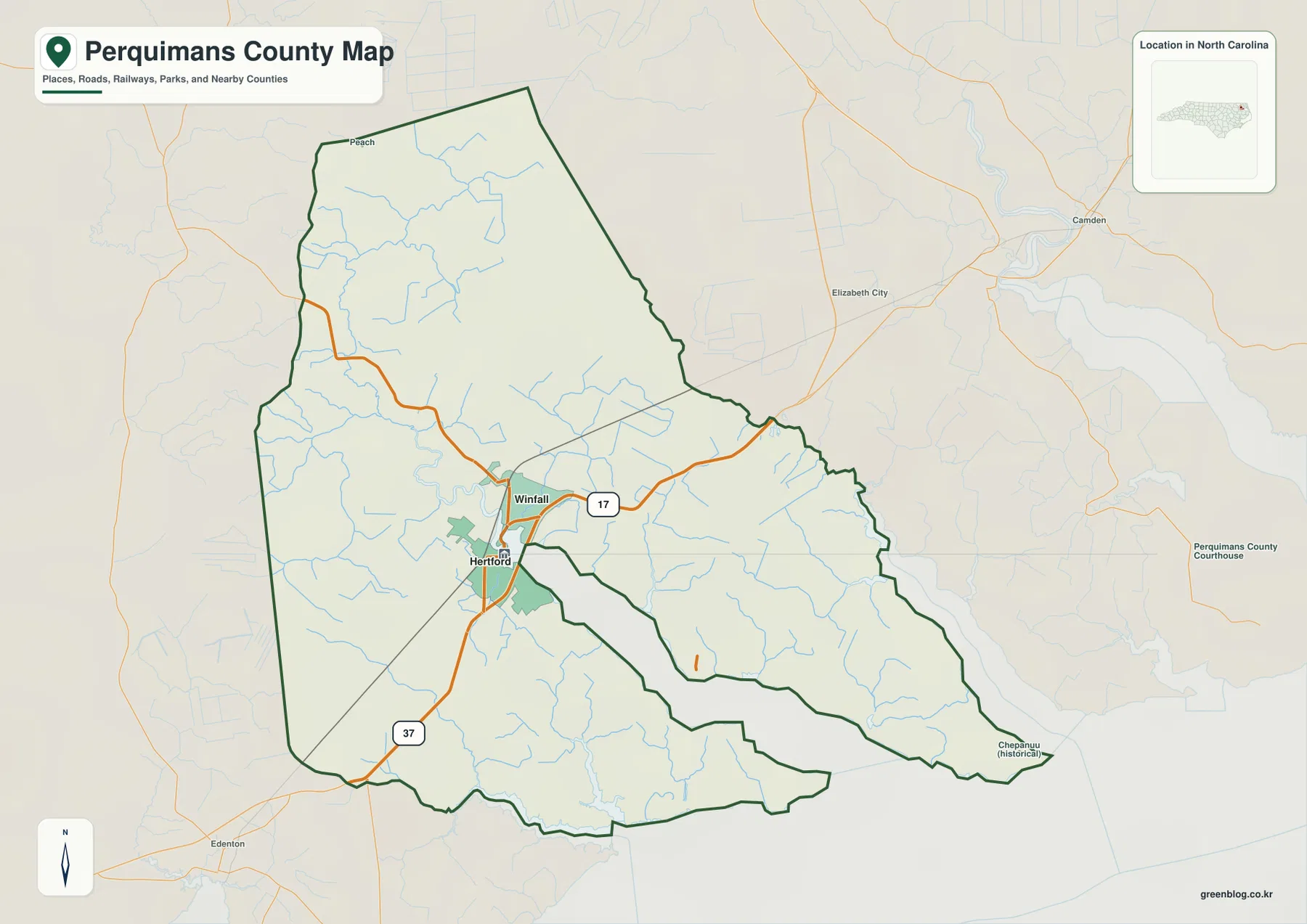
Thin blue waterways are visible throughout the county even on the general map. They are especially noticeable in the north, west, and southern portions, where the road network is less dominant than around Hertford and Winfall. This is an important clue for reading the county correctly: the two towns explain the main urban reference, but they do not explain the shape of the eastern and southern sections. The terrain-and-water map adds that missing physical detail.
The city map highlights two nearby centers rather than a large urban network
The supplied city-distribution map ranks two places. Hertford is shown first and Winfall second, with the values 1,618 and 697 printed in the City Index. Those figures are the values displayed on this specific map; this article does not treat them as independently updated population estimates. The useful information is the location and ranking pattern: the county’s two major mapped towns are close to each other instead of being located at opposite ends of the county.
Hertford sits south of Winfall, and both are concentrated in the central-western area. The current county material also uses Belvidere as a northern rural reference, even though Belvidere is not included as a ranked city on this city map. That distinction matters because a two-city index should not be read as a complete inventory of every settlement or rural place in the county. The city map is best used for the principal town pattern, while the general map and existing county description provide wider geographic context.
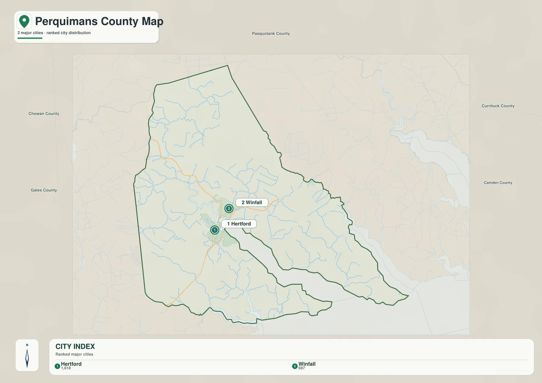
County names around the outside include Pasquotank, Chowan, Gates, Currituck, and Camden. They help position Perquimans County within northeastern North Carolina, but the city map is not intended as a legal boundary or adjacency survey. Its main purpose is to remove road clutter and show where Hertford and Winfall sit relative to the county as a whole.
Perquimans River is only one part of a dense creek-and-sound system
The terrain-and-water map makes Perquimans County look much more intricate than the road map. Perquimans River is labeled in the northern part of the county and continues south through the interior before widening toward the lower county. Little River appears separately on the eastern side. Together they show that the county is not organized around one straight river channel; several waterways occupy different parts of the low coastal landscape.
Goodwin Creek, Mill Creek, Raccoon Creek, and Bethel Creek are all labeled in the western and central portions. Goodwin Creek extends through the west, Mill Creek reaches the central water network, and Raccoon and Bethel Creeks help describe the southwestern interior. These smaller names are valuable because much of the land outside Hertford and Winfall has few major road labels. On the water map, those supposedly quiet areas become a detailed network of channels rather than empty space.
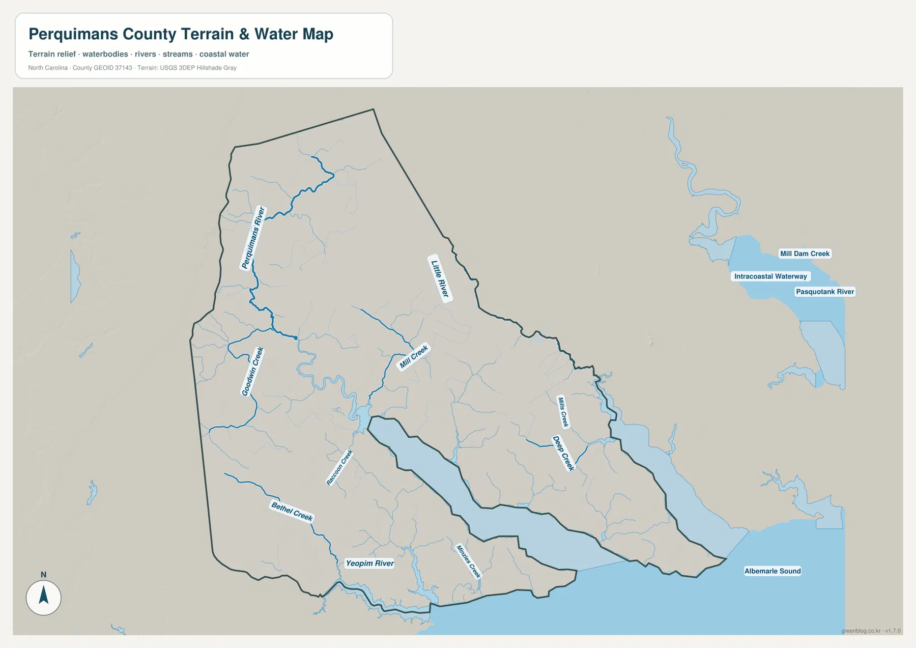
The southern side adds Yeopim River near the county edge, while Nixon Creek and Deep Creek are labeled farther east. Albemarle Sound fills the broad water area along the bottom of the map and provides the clearest large-scale reference for the county’s southern end. Outside the county to the east, Pasquotank River, the Intracoastal Waterway, and Mill Dam Creek appear as regional context. Those external labels should be kept separate from the waterways that actually lie within the Perquimans boundary.
Terrain shading is subdued because the supplied map does not show mountains or large elevation changes. Water is the stronger physical feature: rivers and creeks repeatedly divide the low Coastal Plain before meeting larger water bodies. This map should be used as a general geographic water reference, not as a flood-hazard map, navigation chart, parcel survey, or legal shoreline product. Detailed technical hydrography should be checked against the official USGS source linked below.
The county changes from northern rural land to a sound-facing southern edge
Perquimans County is small enough that Hertford and Winfall can dominate a quick glance, but the maps show a meaningful north-to-south change. The northern part has a broad rural interior crossed by smaller streams, and the existing county material identifies Belvidere as a useful northern rural reference. Moving south brings Winfall and then Hertford into the road-centered part of the county, with US 17 providing the clearest transportation reference.
South of Hertford, waterways become more useful than town names for orientation. Raccoon Creek, Bethel Creek, and Yeopim River appear before the county reaches Albemarle Sound. That sequence explains why a description based only on the two ranked towns would be incomplete. US 17 helps readers find the inhabited center, while Perquimans River and the sound explain how the county opens toward larger coastal water.
The existing page material also states that Perquimans County dates to 1668 in the old Albemarle region. This article is not a full county history, but that source detail fits the geographic emphasis of the supplied maps: Albemarle Sound remains the largest physical feature on the southern side. Hertford provides the administrative and town reference, while the river and sound provide a broader natural frame for the county.
Use the road map for town locations and the water map for the county’s finer geography
The general county map is the best starting point when you need Hertford, Winfall, US 17, NC 37, and the county outline in one view. The city map is much cleaner and works well when the question is simply where the two ranked major towns sit. When the focus shifts to the Perquimans River, Little River, creek names, Yeopim River, or Albemarle Sound, the terrain-and-water map provides much more useful detail.
Reading the three views together gives the same places different but complementary context. Hertford appears as a road-connected center on the general map, the first-ranked town on the city map, and a useful location reference near the county’s larger river-and-sound system. Winfall sits just to the north and helps mark the transition from the Hertford area toward the broader rural north. The water map then explains why the eastern and southern parts of the county cannot be understood from town labels alone.
The download ZIP contains three high-resolution A3 JPG files corresponding to the general county map, city-distribution map, and terrain-and-water map shown on this page. These files are larger than the WebP previews and are intended for printing, close inspection, and document use. They are general geographic references, so legal boundary decisions, surveying, flood determinations, and navigation should rely on the appropriate official technical data.
Frequently Asked Questions
How are Hertford and Winfall positioned on the county map?
Winfall is shown just north of Hertford, and US 17 passes through the same central-western part of the county. The two towns are close enough that they work well as a paired reference for finding the county’s main road-centered area.
What waterways are shown besides the Perquimans River?
The map labels Little River, Goodwin Creek, Mill Creek, Raccoon Creek, Bethel Creek, Yeopim River, Nixon Creek, and Deep Creek. Albemarle Sound occupies the broad southern water area, so the smaller channels can be viewed in relation to a much larger coastal water body.
What files are included in the download ZIP?
The archive contains three high-resolution A3 JPG files corresponding to the general county map, the Hertford–Winfall city-distribution map, and the terrain-and-water map with rivers, creeks, and Albemarle Sound.
Map File Information
The ZIP contains three high-resolution A3 JPG files matching the Perquimans County general map, city-distribution map, and terrain-and-water map shown on this page.
- Included Files: Use only the versions confirmed in the article and supplied images
- File Type: Use the confirmed download contents
- Intended Use: Printing, education, presentations, and map-based projects
Related Maps
Sources and References
These references provide county background, boundary and road data, and hydrographic context. The maps on this page are designed as general-purpose geographic references and downloadable map resources, so readers who need current legal boundaries or detailed technical water information should also consult the original agency data.
Green Map creates custom-edited map images using open geographic data sources such as geoBoundaries, Natural Earth, OpenStreetMap, and government open data.
These maps are edited visual materials, not raw data files, and are provided for education, documents, presentations, and graphic reference.