Pender County stretches across a large section of southeastern North Carolina, and the county changes dramatically between its inland center and its Atlantic edge. Burgaw sits near the middle as the county seat, with St. Helena and Rocky Point extending south along the central road corridor. Farther east, Hampstead, Surf City, and Topsail Beach face a landscape of sounds, bays, and ocean shoreline. Between those two settings, the Northeast Cape Fear River and a dense network of smaller creeks cross broad lowlands that look almost empty on a simple road map but become much more detailed on the water map.
This page provides three views of Pender County: a general county map with boundaries, roads, and place names; a city-distribution map that ranks six major settlements; and a terrain-and-water map focused on rivers, creeks, sound water, and the Atlantic coast. You can download the matching high-resolution A3 JPG files together in one ZIP from the map file box below. The WebP images in the article are convenient previews, while the JPG files are the better option for printing, zooming into labels, or placing the maps in a document.
Table of Contents
Burgaw makes the central I-40 and US 117 corridor easy to understand
The general map gives Burgaw the clearest inland reference point. The town is shown near the center of Pender County, with St. Helena just to the south and Rocky Point farther down the same general corridor. I-40 runs north-south through this part of the county, and US 117 follows a similar central route through the Burgaw and Rocky Point area. Near the southern end, NC 133 and US 117 appear close together, helping place the county relative to the Wilmington direction outside the map.
The western side has a different pattern. Atkinson sits well west of Burgaw, close to NC 11 and NC 53, while Long Creek appears farther south. US 421 crosses the western interior and meets NC 210, giving the southwest another major road reference that does not depend on Burgaw. Reading US 421 and NC 210 alongside I-40 and US 117 makes it clear that Pender County has several inland routes rather than one road spine serving every part of the county.
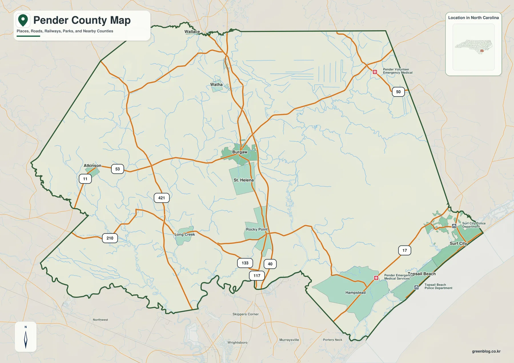
The northern edge adds Watha as an internal reference, while Wallace appears just beyond the county boundary. On the eastern side, NC 50 is visible near the upper corner, and US 17 becomes the strongest road reference for Hampstead and Surf City. The coastal road pattern does not look like a simple continuation of the Burgaw corridor. Reaching the east requires crossing a broad interior before US 17 and the shoreline communities become the dominant features, which is why Burgaw and Surf City work better as separate orientation points.
Surf City and Burgaw anchor opposite sides of the county’s settlement pattern
The city-distribution map ranks six places in the supplied map set. Surf City appears first, Burgaw second, St. Helena third, Atkinson fourth, Topsail Beach fifth, and Watha sixth. The City Index also prints numeric values beside the names, but this article treats those figures only as values shown on the map rather than as independently updated population estimates. The more useful information is the spatial arrangement: the ranked places are spread from the western interior to the Atlantic side instead of forming one compact urban cluster.
Surf City and Topsail Beach sit at the far eastern edge, Burgaw and St. Helena occupy the central interior, Atkinson stands apart in the west, and Watha lies north of Burgaw. That layout explains why the county seat does not provide a complete picture of Pender County’s settlement geography. Burgaw is the natural administrative reference, but Surf City is the more direct marker for the coast, and Atkinson is useful when discussing the rural western side.
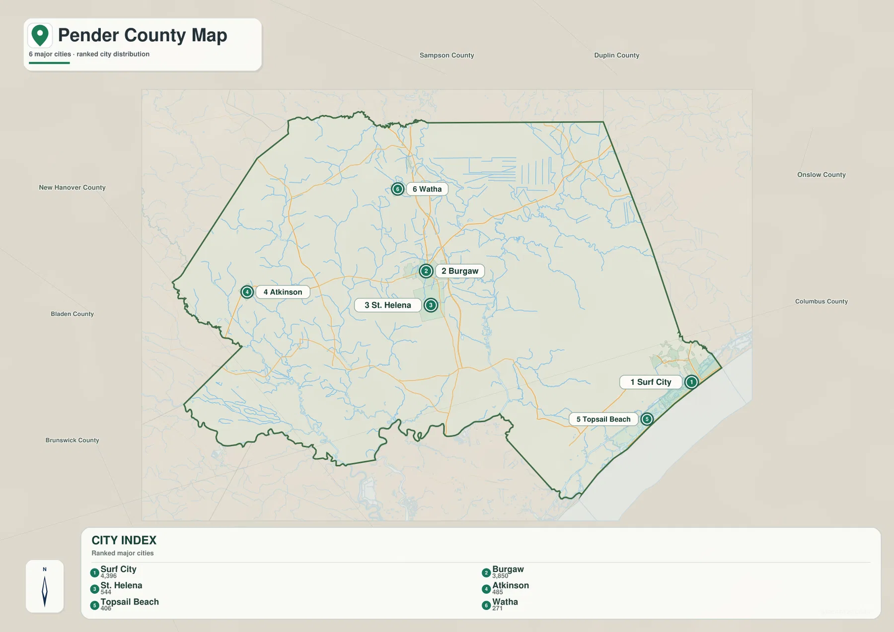
Several neighboring county names appear outside the boundary, including Sampson, Duplin, Onslow, New Hanover, Bladen, and Brunswick. Those labels provide regional orientation rather than a detailed legal adjacency survey. They help show how far Pender County extends across southeastern North Carolina: the county reaches toward the Wilmington area on the south, inland farming and forest country on the west, and the Topsail coast on the east.
The Northeast Cape Fear River reveals the broad water-rich interior behind the road map
The terrain-and-water map changes the county’s appearance. The Northeast Cape Fear River runs through the central-eastern interior and serves as one of the strongest physical references on the map. Black River appears on the western side, and Cape Fear River is labeled near the southwestern boundary area. Smaller waterways such as Moore’s Creek, Cypress Creek, and Long Creek occupy the inland west and center, while Holly Shelter Creek and Ashes Creek are marked farther northeast.
This water network explains areas that look sparse on the general road map. East of Burgaw, the Northeast Cape Fear River is joined by many smaller branches and channels across low land. There are fewer large road labels in that part of the county, but the water map shows that the landscape is far from empty. A reader can see why the interior between Burgaw and the coast is not simply one continuous dry plain and why road routes may bend around rivers, wetlands, and creek systems.
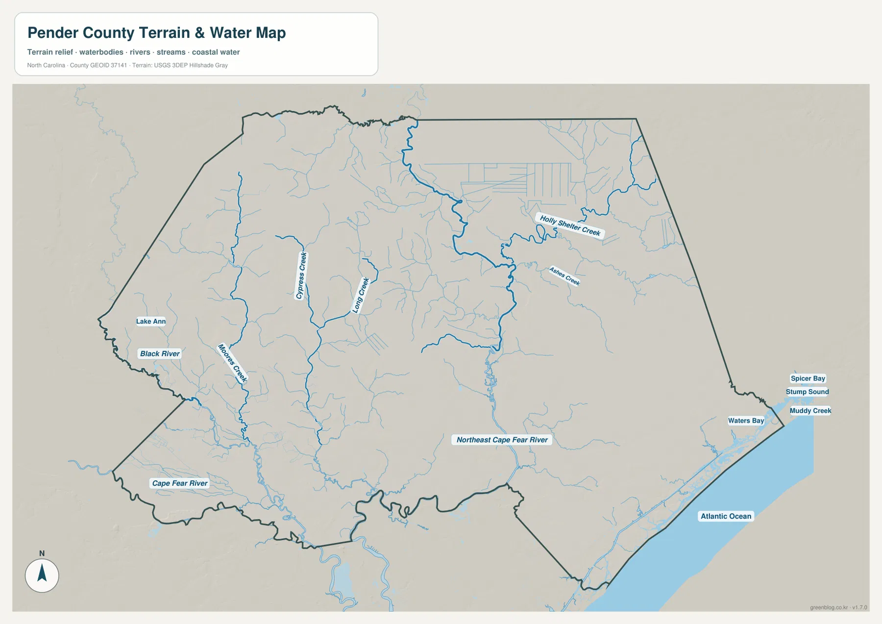
The eastern edge introduces another type of water landscape. Stump Sound, Waters Bay, Spicer Bay, Muddy Creek, and the Atlantic Ocean are all labeled around the Surf City and Topsail area. The narrow coastal strip looks very different from the broad inland county around Burgaw. With sound water on the west side of the barrier-coast area and the Atlantic on the east, the map makes the shoreline geography much easier to understand than a road-only view.
The terrain shading is subtle because the supplied map does not show a mountainous county or major elevation changes. Pender County is better understood through rivers, lowlands, creeks, bays, and coastal water than through high relief. This map is not a flood-hazard product, wetland jurisdiction map, navigation chart, or parcel survey. It is best used to identify the approximate location of named waterways and to understand why the county’s interior and coast have such different shapes.
A west-to-east reading shows how Atkinson, Burgaw, Hampstead, and Topsail belong to different settings
Starting at Atkinson in the west and moving toward Surf City in the east provides a useful way to read the county. Atkinson is tied to NC 11, NC 53, and the western rural road network. Moving toward the center brings Burgaw, I-40, and US 117 into view, with Rocky Point farther south. Continuing east reaches Hampstead and US 17, and the last section of the county becomes increasingly coastal before Surf City and Topsail Beach meet Stump Sound and the Atlantic.
The existing county material in the package notes that Pender County was created from northern New Hanover County in 1875 and that Burgaw was selected as the county seat in connection with its central railroad location. That background fits the map’s central pattern: Burgaw remains a distinct inland hub where major north-south routes and the town area are concentrated. Modern map reading, however, also has to account for the Wilmington-facing southeast and the Topsail coast, so the county cannot be described accurately by the county seat alone.
Hampstead and Surf City are especially useful for understanding that shift. US 17 cuts through the southeastern part of the general map, while the water map places Stump Sound and Atlantic water immediately to the east. Seen together, the two maps show that the coastal communities are not just remote labels at the county edge. Their road access and physical setting are shaped by a narrow, water-dominated landscape that is very different from the Burgaw and Atkinson interior.
Use the road map for inland routes and the water map for the coast and river lowlands
The general county map is the best choice when the task is to locate Burgaw, Rocky Point, Atkinson, Hampstead, or Surf City and then see which numbered route reaches that part of the county. I-40, US 117, and US 421 provide the strongest inland references, while US 17 is the clearest highway for the southeastern coastal side. The city map removes much of that detail and is more useful when you simply want to compare the six ranked settlements without a dense background of road labels.
The terrain-and-water map becomes more useful when the question is physical geography. It shows how the Northeast Cape Fear River passes through the interior, where Black River and the smaller western creeks are located, and how Stump Sound and the Atlantic relate to Surf City and Topsail Beach. It also explains why areas that seem blank on the general map may contain a dense network of waterways and lowland terrain.
The download ZIP contains three high-resolution A3 JPG files corresponding to the general county map, the city-distribution map, and the terrain-and-water map shown in this article. They are larger than the WebP previews and are intended for printing, close inspection, and document use. These are general geographic reference maps, so legal boundary decisions, surveying, flood determinations, wetland jurisdiction, and navigation should rely on the appropriate official technical data.
Frequently Asked Questions
Should I use Burgaw or Surf City as the main reference point on a Pender County map?
Use Burgaw when you need the county seat, I-40, US 117, or the central inland part of Pender County. Use Surf City when the question is the Atlantic side, Stump Sound, US 17, or the Topsail shoreline. The two places represent very different parts of the county, so relying on only one can make the opposite side harder to understand.
Why is the Northeast Cape Fear River important on this county map?
The Northeast Cape Fear River crosses a large part of the central-eastern interior and helps explain the broad lowland between Burgaw and the coast. The water map shows many smaller channels joining or approaching the river, revealing geographic detail that is easy to miss on the road map.
What files are included in the Pender County download ZIP?
The archive contains three high-resolution A3 JPG files matching the general county map, the ranked city-distribution map, and the terrain-and-water map with the Northeast Cape Fear River, Black River, creeks, Stump Sound, and Atlantic shoreline.
Map File Information
The ZIP contains three high-resolution A3 JPG files matching the Pender County general map, city-distribution map, and terrain-and-water map shown on this page.
- Included Files: Use only the versions confirmed in the article and supplied images
- File Type: Use the confirmed download contents
- Intended Use: Printing, education, presentations, and map-based projects
Related Maps
Sources and References
- Pender County – About Pender County
- U.S. Census Bureau – TIGER/Line Shapefiles
- USGS – National Hydrography
These references provide county background, boundary and road data, and hydrographic context. The maps on this page are designed as clear general-purpose geographic references and downloadable map resources, so readers who need current legal boundaries or detailed technical water information should also consult the original agency data.
Green Map creates custom-edited map images using open geographic data sources such as geoBoundaries, Natural Earth, OpenStreetMap, and government open data.
These maps are edited visual materials, not raw data files, and are provided for education, documents, presentations, and graphic reference.