Cochran County sits on the western Texas High Plains, where the county map is defined less by dense settlement than by long rural roads, broad elevation changes, and widely separated communities. Morton is positioned in the northeastern half of the county, Whiteface lies against the eastern side farther south, and Bledsoe is near the New Mexico side in the west. The general map shows those places together with a network of numbered roads, while the terrain-and-water map contains only a small number of visible drainage lines and labels Sulphur Draw near the southeast. The elevation map ranges from about 1,087 to 1,220 meters with a mean near 1,158 meters and shows a clear decline from the higher west toward the lower east. The four matching county, city, water, and elevation maps are available as high-resolution JPG files in the ZIP download on this page.
Morton is the easiest place to use as an anchor because the road pattern is denser around the town than elsewhere in the county. Whiteface gives the eastern side a second clear settlement reference, while Bledsoe makes the western state-line side easier to locate. Between those communities, the map is dominated by long road segments and open land rather than by additional large towns. The physical maps add the details that the road map hides: shallow drainage, numerous small depressions, and a west-to-east elevation change across the Llano Estacado surface.
Table of Contents
Morton Anchors the Road Pattern, While Whiteface and Bledsoe Mark the County Edges
The general county map makes Morton easy to find because a compact built-up area sits among a relatively dense set of roads. Route numbers 34 and 597 are marked close to town, and additional roads extend south and southeast toward routes 120, 130, and 114. Farther east, routes 125 and 169 help locate the approach toward Whiteface. The road network is not a continuous urban street system; it quickly opens into long rural segments once the Morton area is left behind.
Whiteface is positioned along the eastern boundary in the southern half of the county. It is much smaller on the map than Morton, but it provides an excellent reference for the Hockley and Terry County side. Routes 114 and 125 are visible to the northwest of the town, while 170 and 197 appear farther south. Following those numbers on the general map makes the southeastern part of Cochran County easier to navigate even where there are few other place labels.
Bledsoe creates the opposite edge reference. It sits in the west near the New Mexico boundary and close to routes 262 and 595. The distance between Bledsoe and Morton is filled mostly by straight rural roads rather than built-up areas. This wide open stretch is one of the defining visual features of the county map: the western community, central-northeastern Morton area, and eastern Whiteface area are separated by large blocks of high-plains countryside.
The southern half contains additional road references such as 214 and 260, with route 197 approaching the southeastern side. Road spacing is broad in this part of the county, but the land is not empty. Several faint drainage lines cross the plain, and the southeast road pattern comes close to the low corridor associated with Sulphur Draw. Comparing that part of the county with the terrain map gives the road lines more geographic meaning without relying on generic descriptions of a rural grid.
The Ranked City Map Contains Morton and Whiteface, Not Every Named Community
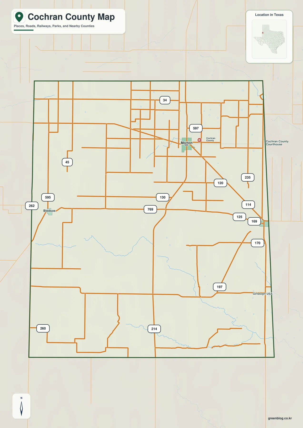
The city-distribution map ranks two major cities. Its CITY INDEX lists Morton at 1,513 and Whiteface at 361. Bledsoe remains visible on the general county map but is not included in this ranked layer. That distinction matters because the city map is designed to simplify settlement distribution rather than reproduce every place name shown elsewhere.
Morton lies above and west of Whiteface, with the two city points occupying the eastern half of Cochran County. A broad rural space separates them, and only a few drainage lines and road segments cross that area. Because the map removes most of the smaller labels, the offset between the county’s main settlement and the eastern-edge community becomes very clear. Whiteface is not simply an extension of Morton; it is a separate point near the county boundary.
County labels around the map include Bailey County to the north, Hockley County to the east, Terry County farther southeast, Yoakum County to the west, and Lamb County to the southwest. Morton sits closer to the Hockley County side, while Whiteface is even nearer the eastern boundary. Bledsoe, although absent from the ranked-city layer, is the place name that makes the New Mexico side of the general map much easier to understand.
The values 1,513 and 361 are the numbers printed in the supplied CITY INDEX. They should be treated as map-index values rather than a replacement for a current population estimate. The map also does not show connector lines or mileage labels, so it should not be used to infer driving distance between the two cities.
Sulphur Draw Is the Clearest Named Water Feature on a Sparse Drainage Map
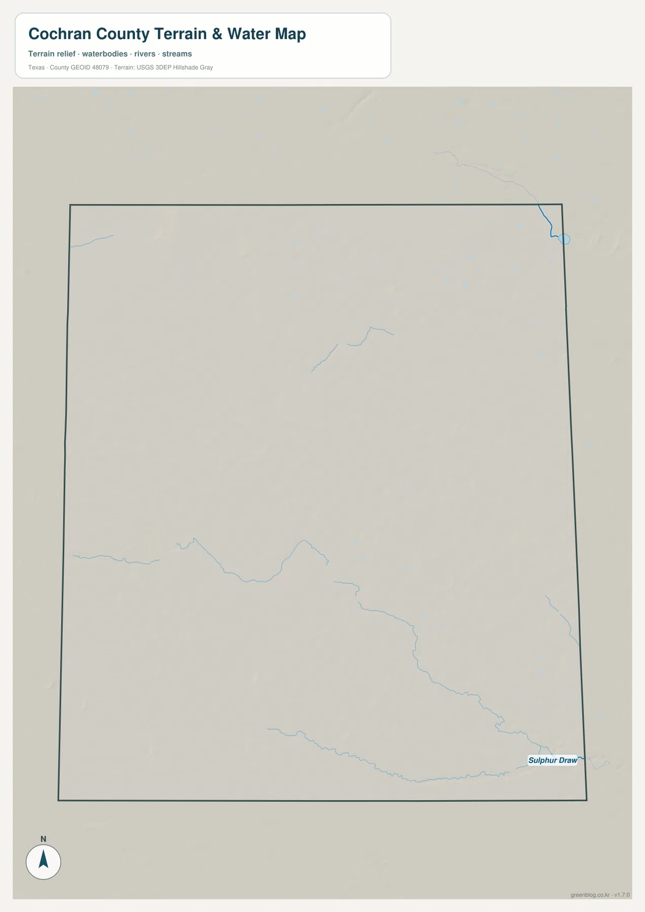
The terrain-and-water map is notably sparse compared with many East Texas or river-border counties. No large river crosses Cochran County, and no major lake dominates the map. The most clearly labeled feature is Sulphur Draw near the southeastern boundary. It follows a long, shallow drainage path toward the east after receiving smaller channels from the south-central part of the county.
Several other drainage lines are visible without prominent labels. A shallow channel crosses part of the southwest, another descends through the south-central interior toward the Sulphur Draw system, and short channels appear near the northeast and southeast edges. Their limited number is itself useful information: surface drainage is much less visually dense here than in a county crossed by major rivers or closely spaced creeks.
The general road map contains some of the same thin blue lines, but they are easy to miss among the orange roads. Removing most transportation detail makes the southeastern low corridor much clearer. Whiteface lies north of part of this drainage country, and route 197 approaches the southeastern side near the lower terrain. Matching the water map to the elevation map is especially useful because the named draw follows a visibly lower green path.
This image is a general geographic reference for surface drainage. It does not show flood risk, current water levels, groundwater depth, irrigation supply, or legal water rights. The existing Cochran County material refers to irrigated agriculture and playa basins on the Llano Estacado, but those topics require additional data beyond this map. The safest use here is to identify Sulphur Draw and the few visible channels and compare their positions with roads and elevation.
Elevation Falls from About 1,220 Meters in the West Toward Lower Eastern Plains
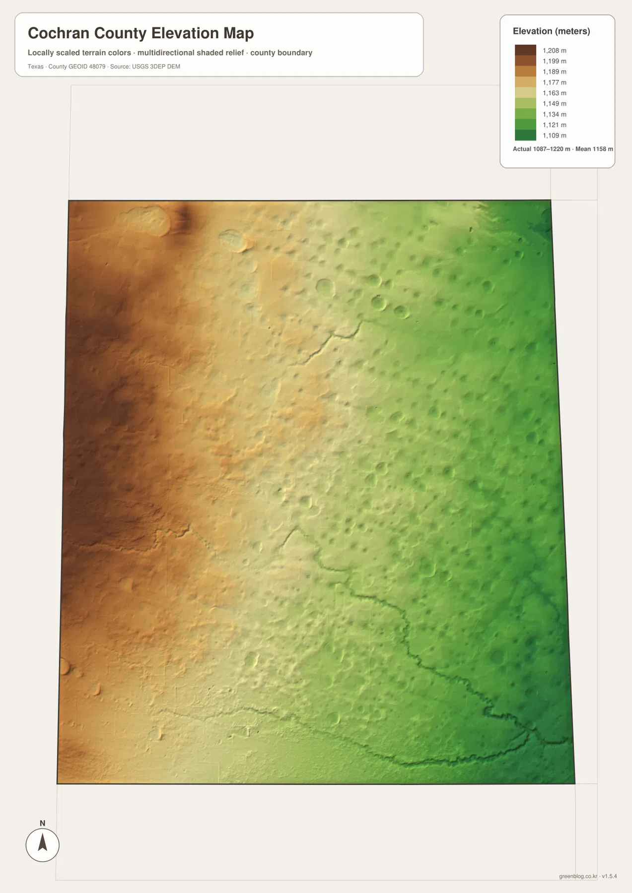
The supplied elevation map reports an actual range of about 1,087 to 1,220 meters and a mean near 1,158 meters. Brown and orange high ground dominates the west and northwest, while yellow, light green, and green colors become progressively more common toward the east. Cochran County is high throughout, but a countywide difference of more than 130 meters creates a very clear west-to-east gradient.
The western high plain is not perfectly smooth. The shaded relief contains many small circular or oval depressions and subtle local hollows. Those shapes are consistent with the playa-basin background referenced in the existing county material, but the elevation image alone cannot establish whether every depression currently holds water. What the map does show directly is that the high western surface is dotted with numerous shallow topographic lows.
Eastward, the overall surface drops and drainage channels become easier to follow. Sulphur Draw appears as a low green corridor near the southeast, and another south-central drainage line cuts across the declining plain. Whiteface lies near the lower eastern side, while Bledsoe is close to the higher western margin. Morton occupies an intermediate position in the east-central part of the county.
The elevation layer is intended for county-scale interpretation, not survey or engineering measurement. It should not be used to determine the precise elevation of a field corner, road grade, well site, or building pad. The 1,087–1,220 meter range and 1,158 meter mean are most useful for explaining the broad High Plains setting and the marked decline from the New Mexico side toward the eastern county line.
Morton, Whiteface, and Bledsoe Reveal the County’s Full East-West Scale
If only the ranked-city map is used, Cochran County can appear to have its settlement pattern concentrated almost entirely in the east. Returning to the general map and adding Bledsoe changes that impression. Bledsoe sits near the New Mexico side, far west of Morton, while Whiteface is close to the opposite edge. The three place names therefore provide a simple way to grasp how wide the county is and how little urban development lies between the western and eastern references.
The elevation pattern reinforces that geographic separation. Bledsoe is on the higher western side, Morton lies farther down the broad slope, and Whiteface is close to the lower eastern greens. This is a direct terrain comparison rather than an assumption about economic or service roles. Even within a county that is broadly part of the Llano Estacado, the west and east do not sit at the same elevation.
South of the main communities, route numbers become more useful than town names for orientation. Routes 214, 260, and 197 provide reference points in large rural sections, and Sulphur Draw helps locate the southeastern low terrain. Cochran County is therefore a good example of a map where boundary position, numbered roads, elevation color, and a few drainage features carry more practical geographic information than a long list of settlements.
Choosing a Cochran County File for Roads, Drainage, or Elevation
The general county map is the most complete single reference for Morton, Whiteface, Bledsoe, and the numbered road network. The ranked city map is cleaner when the goal is to compare only Morton and Whiteface. The terrain-and-water map is the best choice for Sulphur Draw and the sparse surface-drainage pattern, while the elevation map most clearly shows the higher western plain, lower eastern side, and numerous small depressions.
Small road numbers and faint channels can be difficult to read in a reduced browser preview. The original JPG files are more convenient for enlargement and printing. They also work well for side-by-side comparison with Bailey, Hockley, Terry, Yoakum, or other High Plains counties when the same map type and a similar display scale are used.
The ZIP below contains four high-resolution JPG files corresponding to the county, city, water, and elevation maps shown in the article. They can be enlarged for detailed label reading, printed for classroom or personal reference, or arranged with neighboring county maps for regional comparison.
Frequently Asked Questions
Why does the ranked city map show Morton and Whiteface but not Bledsoe?
The supplied city layer ranks two major cities and lists Morton at 1,513 and Whiteface at 361. Bledsoe remains visible on the general county map but is not included in this ranked layer. Use the city map for the two ranked places and the county map when the western Bledsoe reference is also needed.
What is the clearest named water feature on the supplied Cochran County map?
Sulphur Draw near the southeastern boundary is the clearest named drainage feature. Several smaller channels are also visible, but no major river or large lake dominates the supplied terrain-and-water map. The image is a location reference and does not show current water supply or groundwater conditions.
Which side of Cochran County is highest on the elevation map?
The west and northwest are the highest parts of the supplied surface, while elevation generally decreases toward the east. The map reports a range of about 1,087–1,220 meters and a mean near 1,158 meters. Sulphur Draw occupies a lower corridor near the southeast.
Sources and Reference Data
- U.S. Census Bureau TIGER/Line Shapefiles — official geographic boundary, road, and place data.
- USGS National Hydrography — official information about streams, draws, and hydrography.
- USGS 3D Elevation Program — official elevation and terrain data information.
- USGS The National Map Viewer — interactive access to boundaries, transportation, hydrography, terrain, and other geographic layers.
Map File Information
Download the Cochran County county, city, water, and elevation maps together as high-resolution JPG files.
- Included Files: 4 maps
- File Type: JPG
Related Maps
- Bailey County Texas map
- Yoakum County Texas map
- Terry County Texas map
- Parmer County Texas map
- Andrews County Texas map
Green Map creates custom-edited map images using open geographic data sources such as geoBoundaries, Natural Earth, OpenStreetMap, and government open data.
These maps are edited visual materials, not raw data files, and are provided for education, documents, presentations, and graphic reference.