Bailey County occupies a broad piece of the Southern High Plains in western Texas, with Muleshoe standing out as the main urban and administrative center. On the supplied county map, Muleshoe sits in the northeastern part of the county rather than along the New Mexico line. U.S. 70 and U.S. 84 meet there and continue northwest, while State Highway 214 runs south across a large stretch of rural land. The result is a county whose road network and population center are much more concentrated in the northeast than its nearly rectangular outline might suggest.
This page combines four views of the same county: a reference map for roads, places, and boundaries; a city-distribution map that highlights the principal population center; a water map with named draws, playa lakes, and refuge-area water bodies; and an elevation map showing a local range of roughly 1,117 to 1,256 meters. The larger A3 JPG versions of all four maps are also packaged in a single ZIP below, so you can use the WebP maps for quick orientation and download the high-resolution files when you need to print or work offline.
Table of Contents
Muleshoe is the road anchor in a county with a sparse settlement pattern
The reference map makes Muleshoe the obvious starting point. It is close to the northeastern side of Bailey County, and the courthouse marker appears just east of the main town label. Progress is shown to the north, Bula appears well to the southeast, and Goodland is placed in the southwest. Those few labels are spread across a large agricultural landscape, so the page does not read like a suburban county with towns every few miles. The distance between named places is part of the geography.
The highway pattern reinforces that impression. U.S. 70 and U.S. 84 converge at Muleshoe and then share a northwestward corridor across the upper part of the county. State Highway 214 runs almost straight south from Muleshoe, giving the map a strong north-south reference line. A 348 route shield appears near the western side, but the most legible transportation structure is still the combination of the U.S. highways around Muleshoe and SH 214 heading toward the southern county line.
For regional orientation, authoritative county descriptions place New Mexico along Bailey County’s western edge, Parmer County to the north, Lamb County to the east, and Cochran County to the south. That matters because an older description can easily give the wrong impression that Muleshoe itself is on the state line. The supplied map shows otherwise: Muleshoe is east of the county center and much closer to the Lamb County side than to New Mexico. If you are using the map to understand where a trip enters or leaves the county, that distinction is worth getting right.
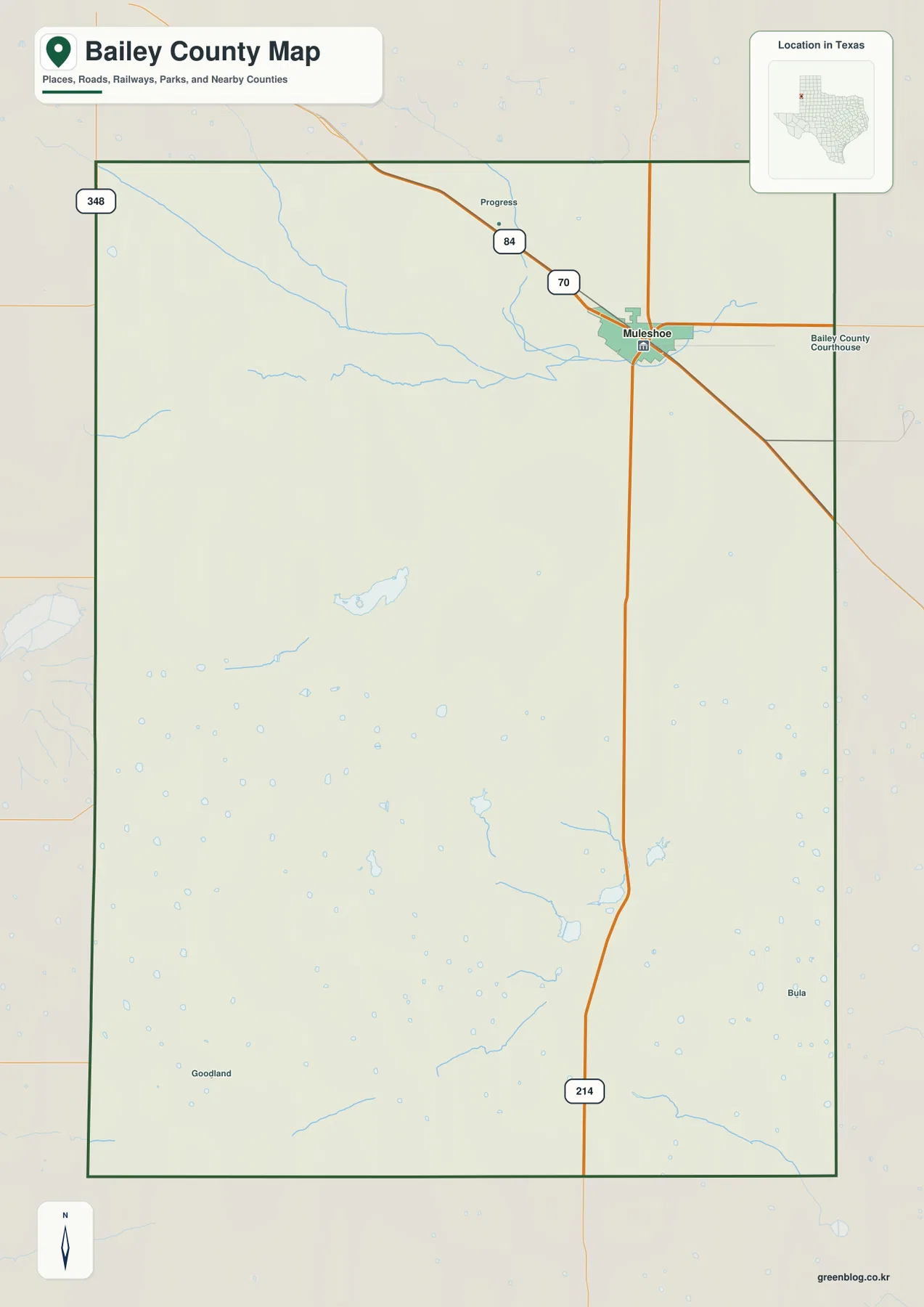
Use this map first when your question involves roads, county orientation, or the position of smaller named communities. It lets you follow the shared U.S. 70–84 corridor, locate the long SH 214 route through the interior, and compare the northeast concentration around Muleshoe with the open southern and western parts of the county. The other maps add water and relief information, but this one supplies the framework that makes those details easier to place.
The city map intentionally reduces Bailey County to one major center
The city-distribution map looks unusually empty because its ranked index contains only one major city: Muleshoe. That does not mean Bailey County lacks smaller communities. It means this particular layer is designed to emphasize the leading population center instead of labeling every settlement, farm community, or historical place. For a reader who wants a quick answer to “where is the county’s main city?”, the simplified map is actually clearer than the general reference map.
Muleshoe’s marker lies near the upper-right portion of the county outline. Parmer County is labeled to the north and Lamb County to the east, while much of the southern half remains free of major-city markers. The composition makes the county’s settlement imbalance easy to see: the principal urban center is not near the geometric middle. That is useful when comparing travel directions, administrative access, or the distance from southern rural areas to county services.
Muleshoe also has a role that goes beyond its size. It is the county seat, and its development is closely tied to the railroad and agricultural economy of the High Plains. The Handbook of Texas describes it as a long-standing market and shipping center for the county. On today’s map, that historical role still makes geographic sense because the town sits where the principal U.S. highways and the north-south state route come together.
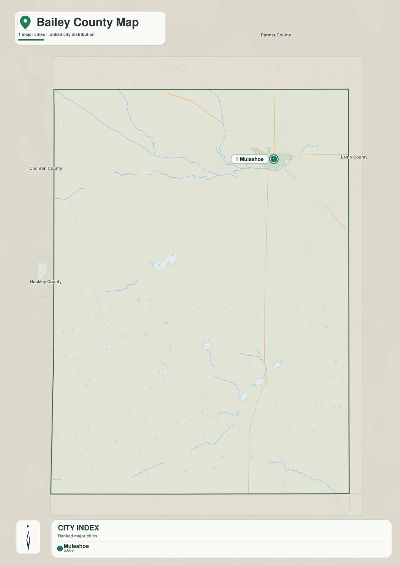
This layer is best for relative placement, not turn-by-turn routing. It does not show the full hierarchy of local communities, and it should not be treated as a complete gazetteer. If you need to locate Progress, Bula, Goodland, or a road junction, return to the reference map. If you only need to understand why Muleshoe dominates county-level orientation, the city map gives the answer with very little visual clutter.
Playas, Blackwater Draw, and refuge lakes tell the county’s water story
Bailey County does not have a single large river cutting across the map. Its water geography is expressed through draws, shallow basins, and a scattered field of small lakes. Blackwater Draw is the most prominent named drainage in the northwest, with Lateral Draw joining the same broad northern system. These channels cross otherwise open High Plains terrain and are much easier to recognize on the water map than on the road-focused reference layer.
Coyote Lake sits farther south and west of center, surrounded by numerous small blue depressions. Many of the tiny water features across Bailey County are associated with playa basins—low spots on the plains where water can collect. The map is useful for seeing how widespread these depressions are, but the blue symbols should not be interpreted as a guarantee of permanent open water. Conditions can vary with rainfall and season, so the layer is better for geographic reference than for determining current water depth or shoreline extent.
The southern cluster is especially distinctive. Baileyboro Lake appears north of Upper and Lower Pauls Lake, followed by Lower Goose Lake, Lower White Lake, and Enochs Pond. These names connect directly with Muleshoe National Wildlife Refuge. The U.S. Fish and Wildlife Service identifies Paul’s Lake, White Lake, and Goose Lake as visitor points within the refuge, which lies south of Muleshoe along the SH 214 direction. That makes the water map more than a list of labels: it shows why the long highway south from Muleshoe leads toward a landscape of playa wetlands and wildlife habitat.
Yellow House Draw is labeled near the southeastern corner and provides a useful contrast with Blackwater Draw in the north. The two features sit in different parts of the county, while the lake cluster occupies the south-central area between them. Instead of one connected river corridor dominating Bailey County, the water map reveals several separate low areas and drainage paths spread across the plain.
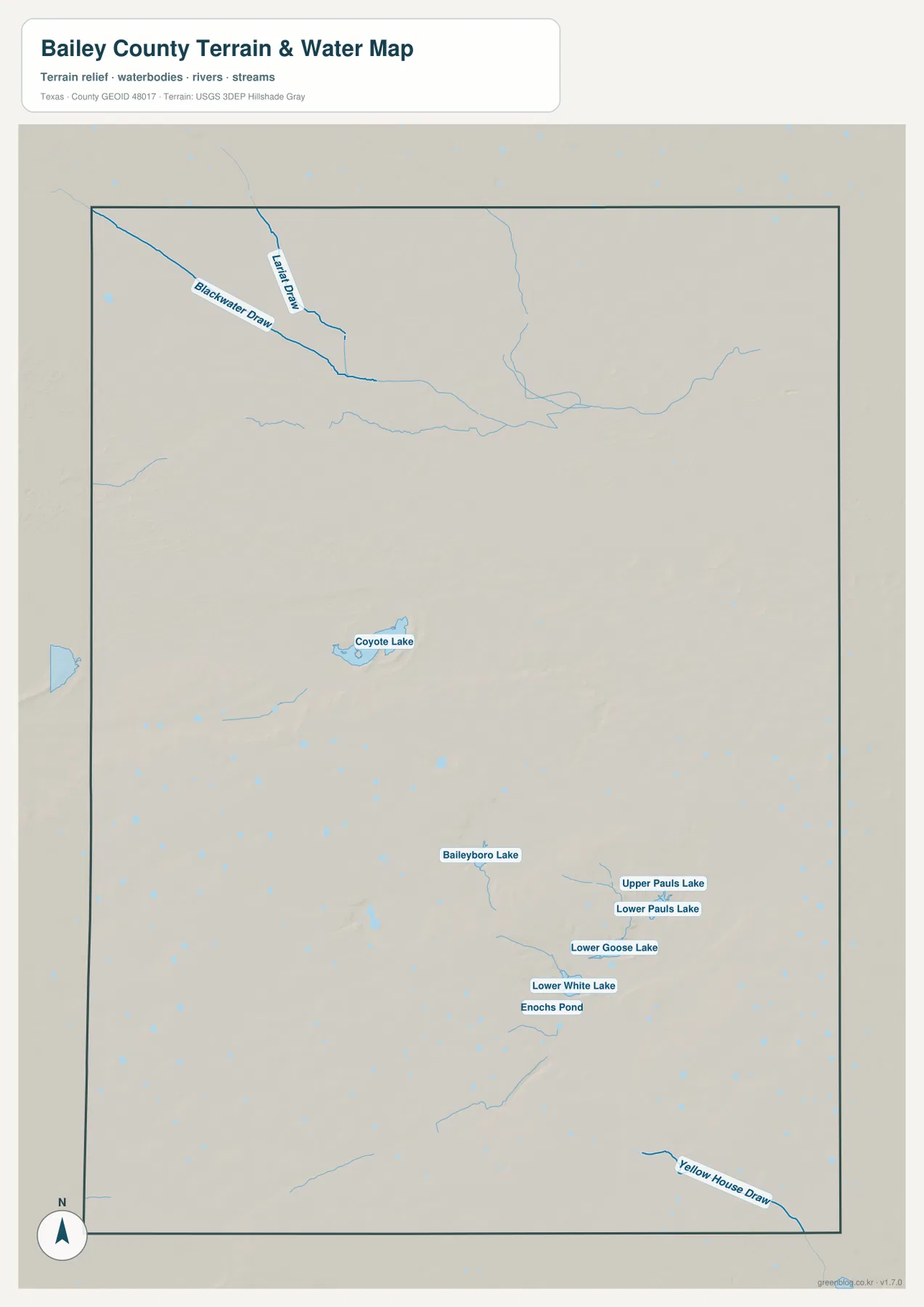
This is not a floodplain, legal water-boundary, or navigation map. It does not provide channel depth, flood frequency, current wetness, or property-level drainage information. Its value is in showing where named draws and lakes sit relative to the county outline and the broader High Plains surface. For flood risk or engineering decisions, use the appropriate official hydrologic and site-specific sources instead.
The elevation map shows a gentle regional slope rather than mountain relief
The elevation map uses strong terrain colors, so the first glance can make Bailey County look more rugged than it is. The legend is the key to reading it correctly. The supplied surface ranges from about 1,117 to 1,256 meters and gives a mean near 1,185 meters, a local spread of roughly 139 meters. Bailey County is part of the Southern High Plains, so these are changes across an elevated plain rather than peaks and deep mountain valleys.
Higher brown and tan shades occupy much of the western and southwestern side, while lower green shades become more common toward the east and northeast. Across the middle, shallow circular depressions and subtle ridges break up the otherwise broad surface. The southeast contains several lower channels and basins, which line up visually with some of the water features shown on the separate hydrology map.
That combination helps explain why the playa pattern matters. A road map can make the county look almost uniformly flat because highways cross the plain in long, direct lines. The relief map reveals that small differences in height are spread throughout the county, and the water map shows that many depressions and named lakes occupy those lower settings. You do not need dramatic hills for elevation to influence where water collects.
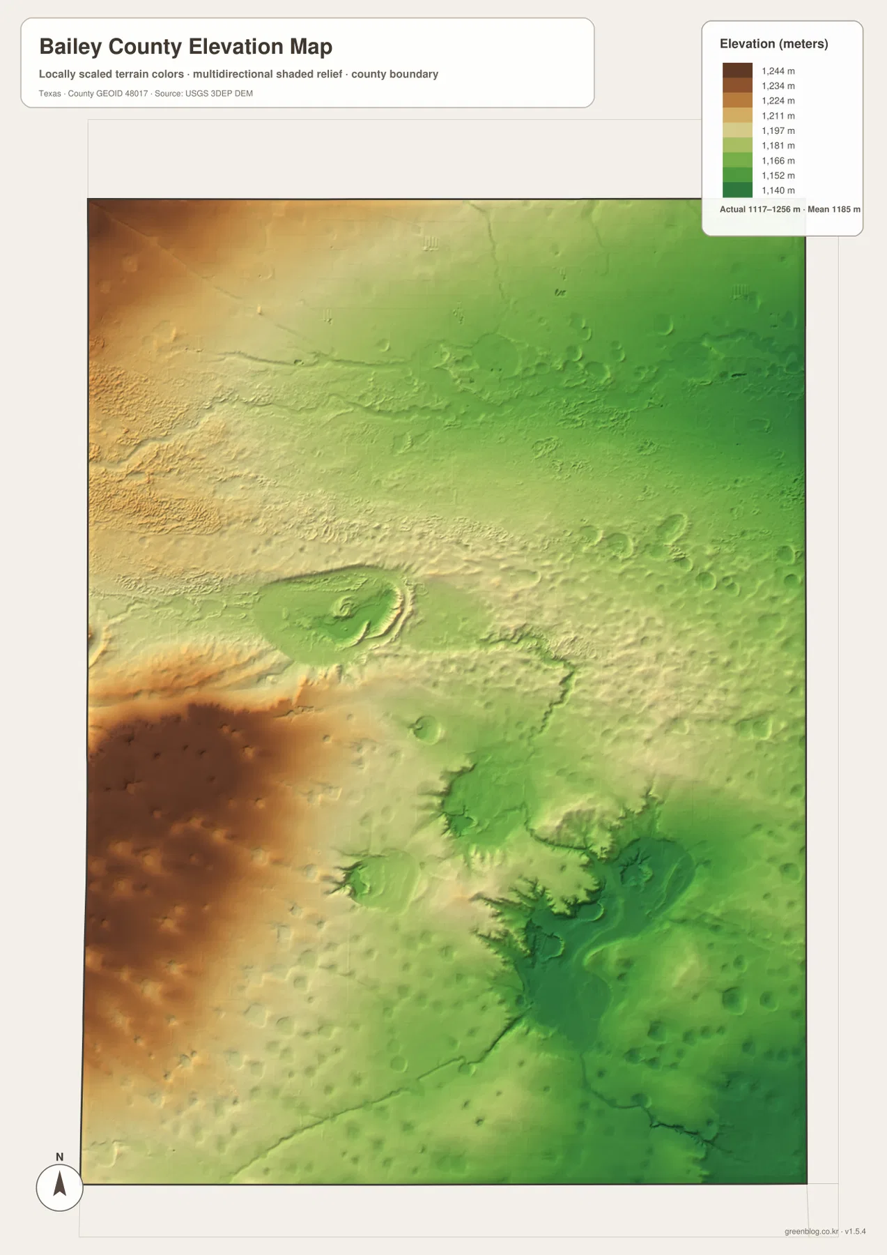
The relief layer is generalized and should be used for county-scale comparison only. It is not survey-grade elevation and does not replace a site survey, engineering model, or detailed irrigation analysis. If a project depends on precise point elevations or drainage slopes, the USGS 3D Elevation Program or a professional survey is the appropriate next source.
Choose the map by the question you are trying to answer
The four maps become most useful when they are treated as complementary rather than interchangeable. For a first look, the county reference map answers the practical questions: where Muleshoe is, which direction U.S. 70 and 84 run, how SH 214 crosses the county, and where a few smaller named places appear. The city map then strips away most of that detail and makes the concentration around Muleshoe unmistakable.
The water and elevation maps add the physical landscape that road lines cannot show. Blackwater Draw, Coyote Lake, the Pauls–White–Goose lake cluster, and Yellow House Draw give the plains a network of low places and seasonal or permanent water references. The elevation layer places those features in a broader west-to-east height difference. Read together, they show why a county that looks simple on a highway map still has meaningful terrain and water variation.
State Highway 214 is a particularly useful cross-reference. On the road map it leaves Muleshoe and runs south. On the city map it starts from the county’s only ranked major city. The refuge-related lakes on the water map lie in the southern direction from that same corridor, and the elevation map lets you compare the terrain on either side. Using one recognizable line across several maps is often the quickest way to move from transportation geography to physical geography without losing your place.
For printing, choose the layer that keeps the important information legible. A classroom handout about towns and highways may need only the reference map, while a lesson about playas or wildlife habitat benefits from the water map. The elevation map works well when the topic is High Plains relief or the relationship between low basins and surrounding ground. Because the ZIP contains all four A3 JPG files, you can select one map for a focused page or place several side by side for comparison.
Frequently Asked Questions
Where is Muleshoe within Bailey County?
Muleshoe is in the northeastern part of Bailey County. U.S. 70 and U.S. 84 meet there, and State Highway 214 runs south from the city. It is the county seat and the clearest reference point on both the general and city-distribution maps.
Why are so many small lakes and blue depressions shown on the water map?
Bailey County lies on the Southern High Plains, where many shallow playa basins occur in low spots across the plain. The supplied map labels Coyote Lake, Baileyboro Lake, Pauls Lake, White Lake, Goose Lake, Enochs Pond, and many smaller features. Their actual water extent can vary, so the map should be read as a geographic reference rather than a real-time water-status map.
Can the elevation map be used for surveying or construction?
No. It is a generalized county-scale surface intended to compare relative height across Bailey County. The displayed range is about 1,117 to 1,256 meters, but any project requiring precise site elevation, drainage grade, or engineering measurements should use detailed source data or a professional survey.
Map File Information
The Bailey County reference, city, water, and elevation maps are packaged together as four high-resolution A3 JPG files in one ZIP archive.
- Included Files: County map, city map, water map, and elevation map — 4 JPG files
- File Type: ZIP archive
Related Maps
Sources and References
- Bailey County, Texas official website — county government and courthouse information
- Handbook of Texas: Bailey County — county location, Southern High Plains geography, transportation, and history
- U.S. Fish & Wildlife Service: Muleshoe National Wildlife Refuge — refuge setting and named lake areas
- U.S. Census Bureau TIGER/Line Shapefiles — county boundary and geographic reference data
- USGS National Hydrography — hydrographic reference data
- USGS 3D Elevation Program — elevation data
Green Map creates custom-edited map images using open geographic data sources such as geoBoundaries, Natural Earth, OpenStreetMap, and government open data.
These maps are edited visual materials, not raw data files, and are provided for education, documents, presentations, and graphic reference.