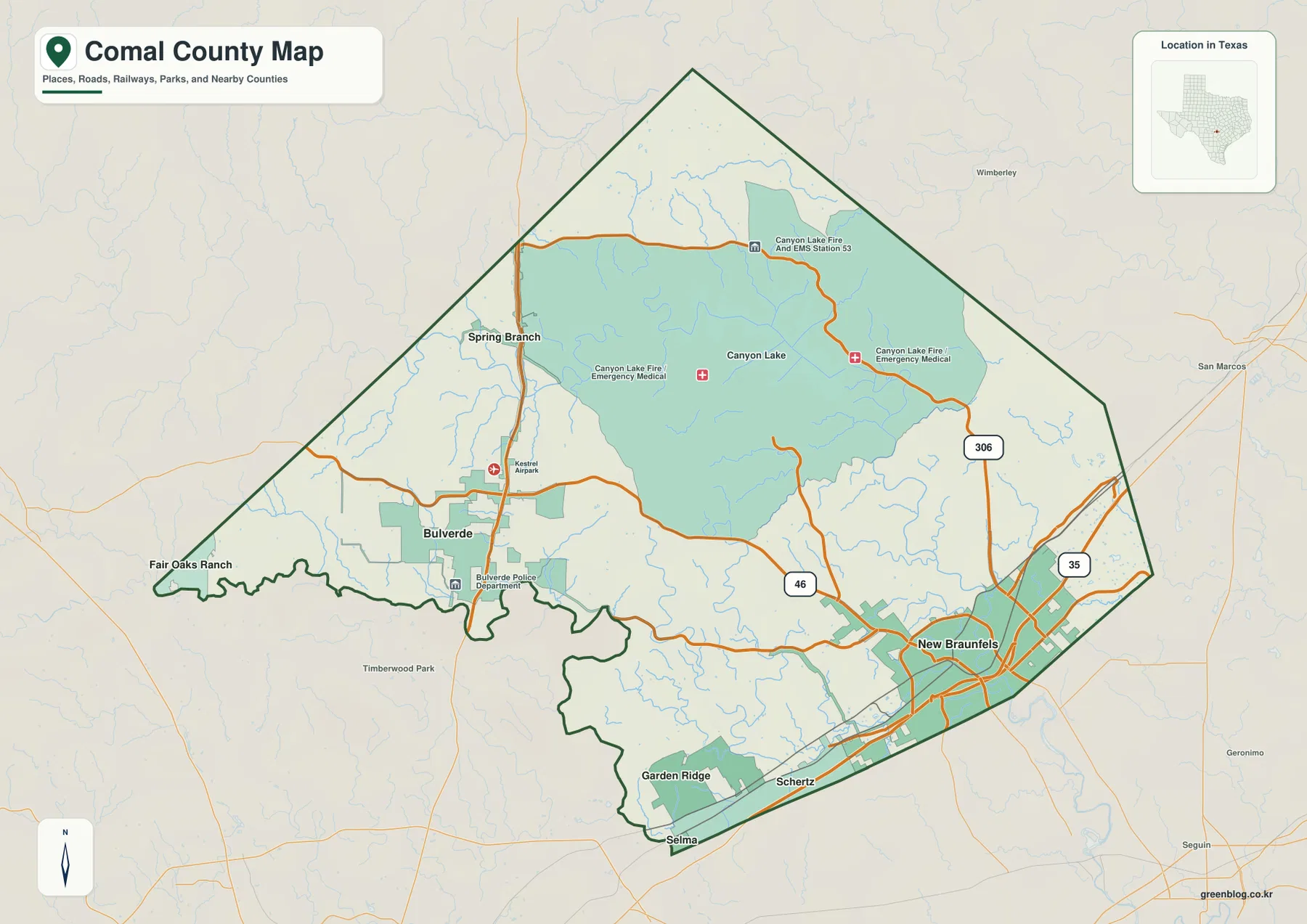
Comal County in Central Texas changes dramatically from the New Braunfels side of Interstate 35 to the rugged Hill Country around Bulverde, Spring Branch, and Canyon Lake. The general county map shows I-35 along the southeastern urban corridor, US 281 through the western county, State Highway 46 between the New Braunfels and Bulverde sides, and Route 306 around the Canyon Lake area. On the terrain-and-water map, Guadalupe River enters the county from the west, widens into Canyon Lake, and then continues toward New Braunfels, where Comal River and Dry Comal Creek add another set of strong water references. The elevation surface ranges from about 167 to 465 meters with a mean near 311 meters, making the high western and northwestern ridges stand out clearly from the lower southeastern valleys. All four county, city, water, and elevation maps are also available as high-resolution A3 JPG files in the ZIP download on this page.
New Braunfels is the easiest starting point because it combines the largest built-up area with the clearest highway corridor. From there, the map opens westward toward Bulverde, northwest toward Spring Branch and Canyon Lake, and south toward Garden Ridge. The western communities sit among higher, more deeply cut terrain, while New Braunfels occupies much lower ground close to the Guadalupe and Comal river system. Looking at those places before the smaller labels makes the county’s sharp east-west contrast immediately understandable without reducing it to a generic road map.
Table of Contents
New Braunfels Anchors I-35 While US 281 Serves the Western Hill Country
New Braunfels is the strongest transportation reference on the general county map. Interstate 35 runs along the southeastern side of the city, where local roads and built-up areas are much denser than elsewhere in Comal County. State Highway 46 extends west from the New Braunfels area toward Bulverde, while Route 306 reaches north toward the eastern side of Canyon Lake. These lines provide a practical way to separate the southeastern urban corridor from the more rugged interior.
US 281 creates a second major north-south reference farther west. Spring Branch lies along the northern part of that corridor and Bulverde is farther south. The road passes through terrain that is visibly different from New Braunfels: development is more broken up, creek valleys are numerous, and the route runs between rolling ridges rather than through one continuous urban area. Following US 281 from Spring Branch toward Bulverde gives a clear sense of the county’s western Hill Country side.
Canyon Lake dominates the north-central interior. Route 306 passes along the lake’s eastern side, and emergency medical and fire-service labels provide additional location references around the shoreline. Roads here bend through the hills and around drainage arms rather than following the denser pattern seen around New Braunfels. The lake is therefore not just a water landmark; it is also one of the best features for understanding how the county road network changes with terrain.
Garden Ridge lies near the southern county edge, with Selma and Schertz visible beyond the boundary. Fair Oaks Ranch sits near the southwestern side of the broader map and helps place the Bulverde corridor relative to the San Antonio direction. San Marcos appears outside the county to the east-northeast, while other nearby communities frame the Hill Country side. These outside references make it easier to see why Comal County functions as a transition between the I-35 corridor and the higher interior rather than as one uniform urban block.
Four Direct-Distance Connections Spread 12 to 31 Miles from New Braunfels
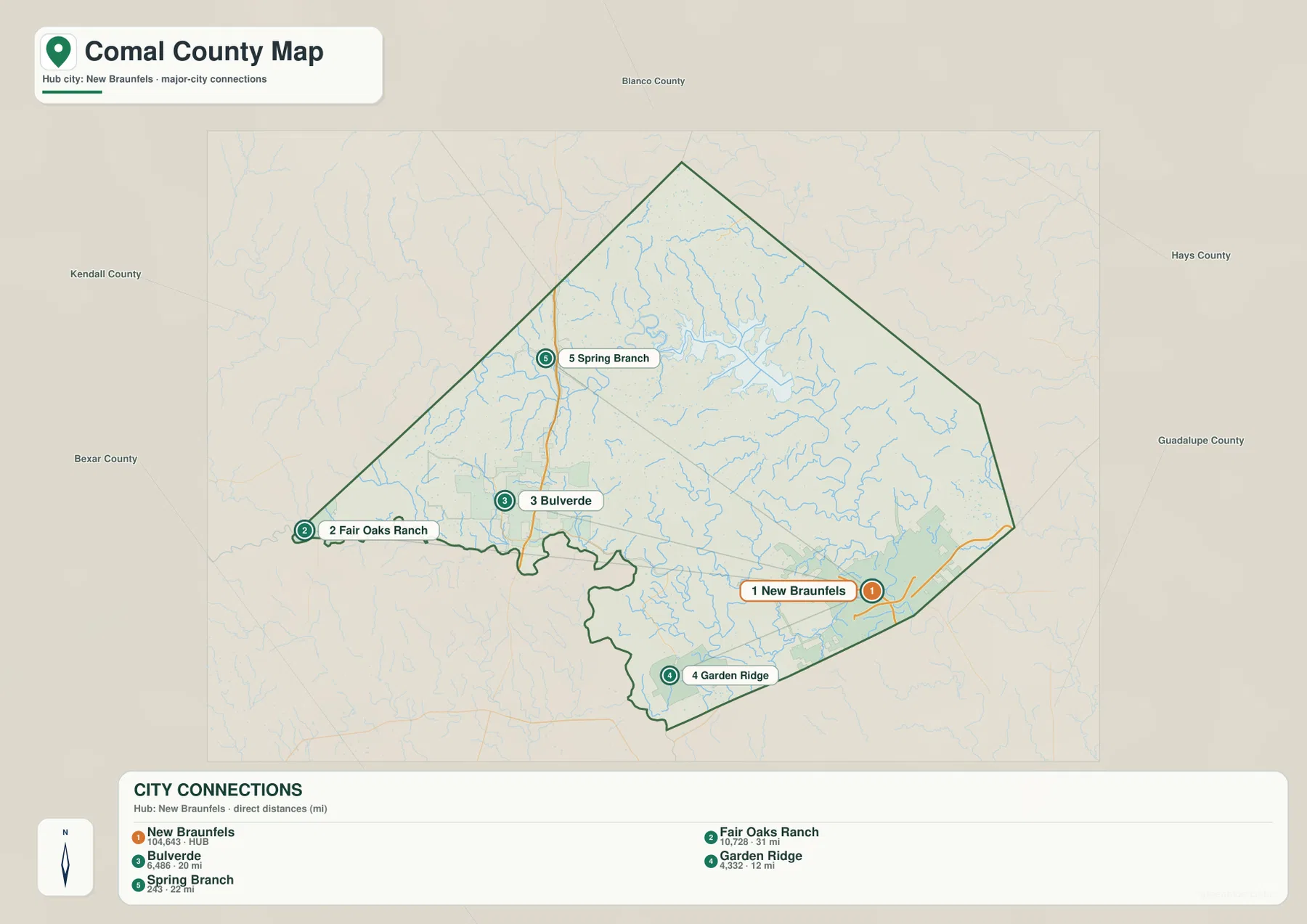
The city-connections map uses New Braunfels as the hub and links it to Fair Oaks Ranch, Bulverde, Garden Ridge, and Spring Branch. The lower CITY CONNECTIONS panel lists New Braunfels at 104,643, Fair Oaks Ranch at 10,728, Bulverde at 6,486, Garden Ridge at 4,332, and Spring Branch at 243. The map is intentionally simpler than the general county layer, so the wide spacing between the southeastern hub and the western communities is easy to see.
The printed mileage values are direct point-to-point distances, not driving distances. Garden Ridge is shown about 12 miles from New Braunfels, Bulverde about 20 miles, Spring Branch about 22 miles, and Fair Oaks Ranch about 31 miles. Actual road mileage will vary with the selected route and the exact origin and destination. For example, a trip toward Bulverde or Spring Branch may involve Highway 46, US 281, or connecting local roads rather than following the straight line shown on the city map.
The directions are as useful as the numbers. Garden Ridge is the closest of the selected connections and lies southwest of New Braunfels. Bulverde and Spring Branch pull the view into the higher western and northwestern part of the county, while Fair Oaks Ranch sits even farther toward the southwest edge of the broader region. The map therefore highlights how New Braunfels is separated from the Hill Country communities by substantial open and rugged terrain rather than by one continuous strip of development.
Canyon Lake does not appear in the CITY CONNECTIONS list even though it is one of the county’s largest geographic features on the other maps. That difference matters. The city layer is designed to compare selected hub connections, while the county and water maps are better for understanding the lake, its roads, and the communities around it. Using the layers together prevents the simplified city ranking from becoming a substitute for the county’s actual physical geography.
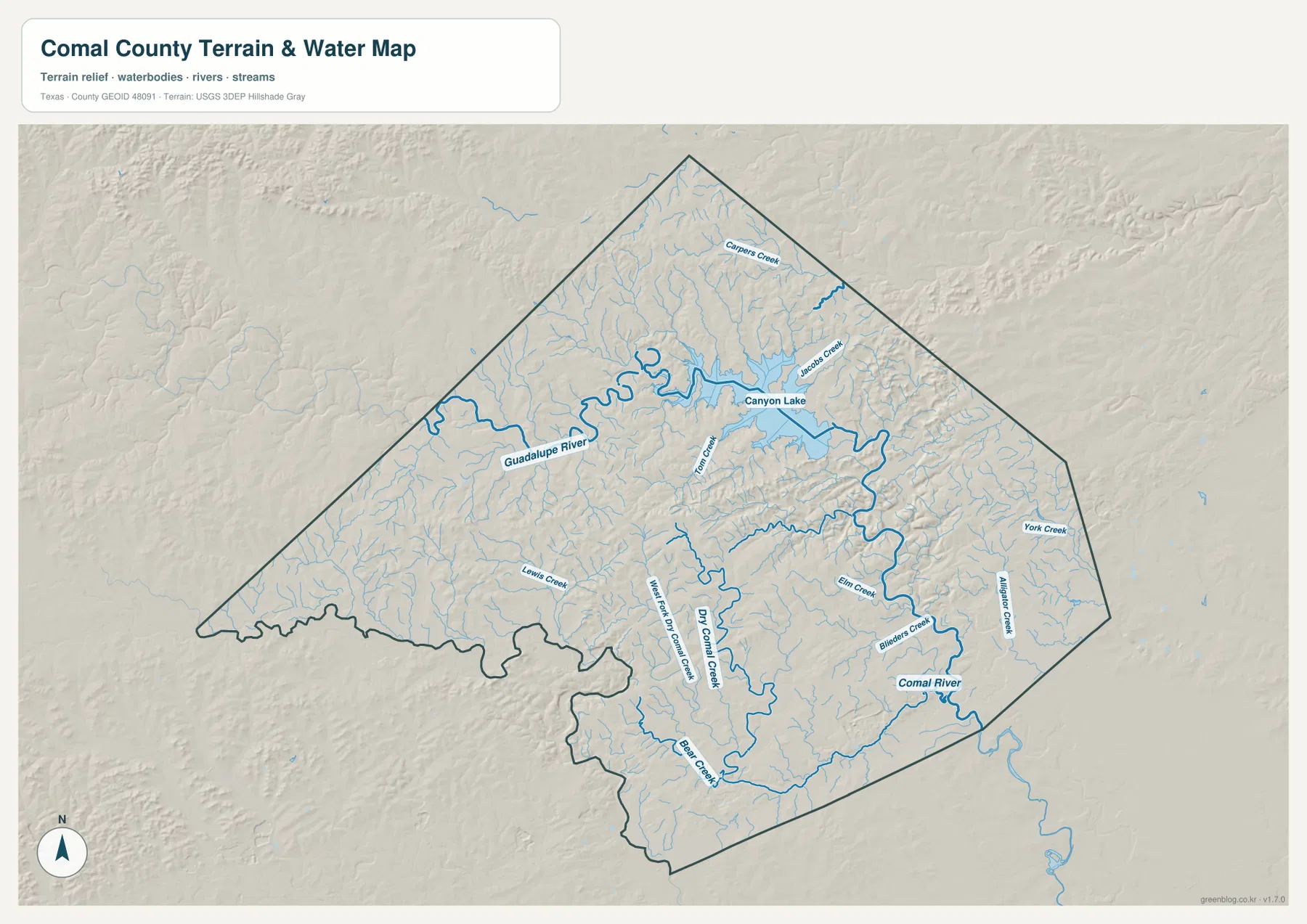
Guadalupe River, Canyon Lake, and Comal River Form the County’s Main Water Framework
Guadalupe River is the dominant line on the terrain-and-water map. It enters from the western side, winds through the Hill Country, and expands into Canyon Lake in the north-central county. Below the reservoir, the river continues east and southeast through a deeply cut corridor toward the New Braunfels side. The change from a winding upstream river to a broad reservoir and then back to a confined river valley is one of the most distinctive features in the entire map set.
Canyon Lake receives several smaller named streams. Carpers Creek is labeled north of the lake, Jacobs Creek approaches from the northeast, and Tom Creek enters near the western-southern side of the reservoir. Their branching valleys help explain the irregular shoreline and the rugged relief around the lake. On the elevation map, those same drainage arms appear as low green channels surrounded by much higher ridges.
Near New Braunfels, Comal River provides another strong water reference. It is shorter than the Guadalupe but is shown prominently in the southeastern county. Dry Comal Creek and West Fork Dry Comal Creek extend through the interior toward the same broad area, with Bear Creek joining the southern drainage. Farther east, Elm Creek, Blieders Creek, York Creek, and Alligator Creek occupy separate valleys, while Lewis Creek provides a useful western reference.
This terrain-and-water image is intended for general geographic reference. It is not a flood-hazard map, parcel or legal-boundary map, depth chart, water-quality report, swimming-safety guide, or navigation product. Those uses require specialized official information. For ordinary map reading, Guadalupe River, Canyon Lake, Comal River, and the named creeks provide a clear framework for comparing the county’s water features with settlements and roads.
Elevation from About 167 to 465 Meters Separates the Hill Country from the Southeast
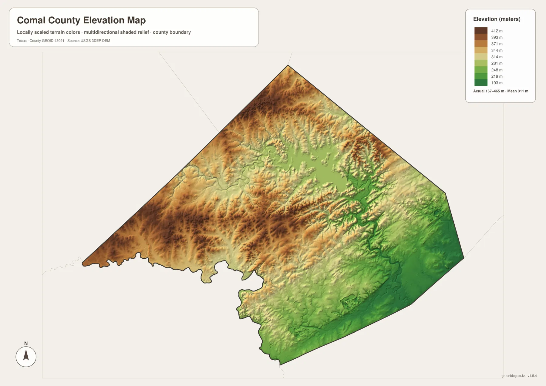
The supplied elevation map reports an actual range of approximately 167 to 465 meters and a mean near 311 meters. The highest brown and dark-orange terrain is concentrated across the west, northwest, and northern ridges. The southeastern side around New Braunfels is much greener and lower. With nearly 300 meters of county-wide relief, the transition from the western Hill Country to the Guadalupe–Comal lowlands is far more pronounced than the general road map alone suggests.
Canyon Lake sits within a deeply dissected landscape rather than on a flat upland. The reservoir occupies a lower basin surrounded by high ridges, and the Guadalupe River below the lake follows a sharply defined green valley. When the elevation surface is compared with the water map, the winding river and its tributaries align closely with the lowest corridors. This relationship explains the dramatic texture visible around the lake and the eastward river route.
Bulverde and Spring Branch occupy the higher western side. Short drainage valleys repeatedly cut through the ridges near the US 281 corridor, so the terrain is rolling and locally steep even where the main highway looks straightforward. Moving south and southeast toward Garden Ridge and New Braunfels, the map becomes progressively lower and the relief softens. The contrast is especially clear when the western brown uplands are compared directly with the broad green southeastern corner.
This elevation surface is appropriate for county-scale comparison, not survey or engineering measurement. It should not be used to determine the precise elevation of a house, parcel corner, road grade, or construction site. The 167–465 meter range and 311 meter mean are best treated as broad reference values for comparing the western and northern ridges, the Canyon Lake basin, and the lower New Braunfels side.
The Map Changes from US 281 Hill Country to the New Braunfels River Lowlands
The strongest county-wide contrast appears when the Spring Branch–Bulverde side is compared with New Braunfels. Western Comal County contains higher ridges, narrower valleys, and more widely spaced development. Around New Braunfels, elevation is lower, the I-35 road pattern is denser, and the Guadalupe–Comal river system becomes a much stronger visual presence. The two areas are connected by major roads, but they occupy clearly different physical settings.
Canyon Lake helps connect those settings geographically. It lies within the higher northern interior, yet the Guadalupe River leaving the reservoir descends directly toward the lower New Braunfels side. Route 306 and Highway 46 help establish the road relationship, while the water and elevation layers explain the terrain between them. The lake therefore serves as a useful middle reference between the western Hill Country and the southeastern urban corridor.
Garden Ridge offers another comparison. It is only about 12 miles from New Braunfels on the straight-line city map, but its setting differs from Bulverde and Spring Branch farther west. Distance alone does not describe those differences. Comparing each point with the road corridor, local streams, and elevation makes the county’s internal geography much clearer.
Choose the File by Road Detail, City Distance, Water, or Relief
The general county map is the best single reference for New Braunfels, Bulverde, Spring Branch, Garden Ridge, Canyon Lake, I-35, US 281, Highway 46, and Route 306. The city-connections map is cleaner when the goal is to compare the selected direct distances from New Braunfels. The terrain-and-water map is the best choice for Guadalupe River, Canyon Lake, Comal River, Dry Comal Creek, and the smaller named streams. The elevation map most clearly shows how quickly the county rises from the southeast into the western and northern Hill Country.
Small creek labels and minor road details can be difficult to read in a reduced browser preview. The original JPG files are more convenient for enlargement and printing. They also work well for side-by-side comparison with Hays, Guadalupe, Kendall, Bexar, or other Central Texas counties when the same map type and a similar display scale are used.
The ZIP below contains four high-resolution A3 JPG files corresponding to the county, city, water, and elevation maps shown in the article. They can be enlarged for detailed label reading, printed for classroom or personal reference, or arranged with neighboring county maps for regional comparison.
Frequently Asked Questions
Are the city-connection mileages from New Braunfels driving distances?
No. The supplied city map shows straight-line distances: about 12 miles to Garden Ridge, 20 to Bulverde, 22 to Spring Branch, and 31 to Fair Oaks Ranch. Driving distance varies with the route and the exact starting and ending points.
How are Guadalupe River and Canyon Lake connected on the map?
Guadalupe River enters Comal County from the west and widens into Canyon Lake. Below the reservoir, it continues southeast toward New Braunfels. Comal River and the Dry Comal Creek system provide additional water references around the New Braunfels side.
Which part of Comal County is highest on the supplied elevation map?
The western and northwestern Hill Country contains much of the highest terrain. The map reports an elevation range of about 167–465 meters with a mean near 311 meters, while the Guadalupe River corridor and southeastern New Braunfels side occupy lower ground.
Sources and Reference Data
- U.S. Census Bureau TIGER/Line Shapefiles — official geographic boundary, road, and place data.
- USGS National Hydrography — official information about Guadalupe River, Comal River, Canyon Lake, and other waterways.
- USGS 3D Elevation Program — official elevation and terrain data information.
- USGS The National Map Viewer — interactive access to boundaries, transportation, hydrography, terrain, and other geographic layers.
Map File Information
Download the Comal County county, city, water, and elevation maps together as high-resolution A3 JPG files.
- Included Files: 4 maps
- File Type: JPG
Related Maps
- Atascosa County Texas map
- Bandera County Texas map
- Wilson County Texas map
- Travis County Texas map
- Uvalde County Texas map
Green Map creates custom-edited map images using open geographic data sources such as geoBoundaries, Natural Earth, OpenStreetMap, and government open data.
These maps are edited visual materials, not raw data files, and are provided for education, documents, presentations, and graphic reference.