Grady County lies in southwestern Georgia, with Cairo as the county seat and the main road center, Whigham to the west, and a dense network of creeks cutting across broad rural areas. The map set on this page is designed to make those features easier to separate. The county map shows Cairo, Whigham, Calvary, Pawnee, numbered roads, and the boundary. The city view reduces the county to its two ranked major cities, while the water map labels the Ochlockonee River, the Tired Creek system, Wolf Creek, Burntbridge Creek, and several smaller waters. On the supplied relief map, Grady County spans roughly 32 to 110 meters in elevation, and the mapped mean is 70 meters. After reviewing the previews, you can download four high-resolution A3 JPG originals in one ZIP.
Cairo is the best place to start reading the county. It sits slightly east of center, where Routes 38, 84, 93, 112, and 188 provide strong directional references. Whigham lies west along the Route 38 corridor, Calvary is near the southwestern corner, and Pawnee appears in the northwest. Those place names occupy only a small part of the page compared with the blue drainage lines that spread across the county. Once the water and elevation maps are compared, the open-looking rural interior becomes a much more detailed landscape of low creek valleys, gentle divides, and a broad drainage path toward the Ochlockonee River in the south.
Table of Contents
Cairo as the Road and Place Reference
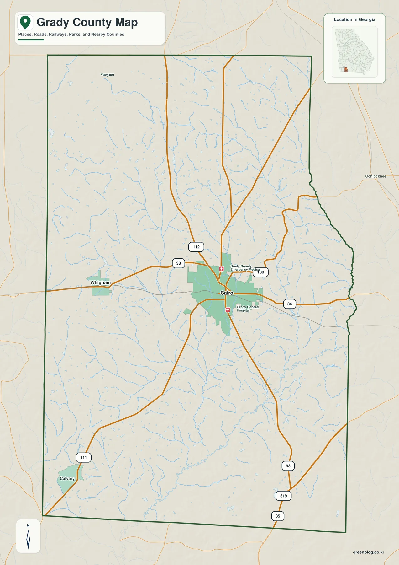
The general map gives Cairo the strongest emphasis because it is the largest developed area and the county seat. Grady County Emergency Medical and Grady General Hospital are labeled nearby, adding useful orientation within the Cairo area. Route 38 approaches from Whigham to the west and reaches Cairo, while Route 84 continues east. Route 112 heads north from the city, Route 188 angles toward the northeast, and Route 93 runs south. These labels are not meant for turn-by-turn navigation, but they make it easy to see how Cairo connects with the main directions across the county.
Whigham is the second major city label and sits clearly west of Cairo. Calvary is marked near the southwest, close to Route 111, while Pawnee appears in the northwestern interior. Farther southeast, Routes 93, 319, and 35 provide additional references near the county edge. Ochlocknee is shown outside the eastern boundary, helping place Grady County within the surrounding part of southwest Georgia. These outer labels are useful because the county itself contains large stretches without dense town names.
The boundary is also more irregular than a simple rectangle. The western and northern sides contain long straight sections, but the eastern edge has several bends and projections. Streams cross almost every part of the interior, especially north and south of Cairo and across the Whigham side. Their density makes the general map useful for more than roads: it shows that the rural spaces between communities are divided by many small drainage valleys rather than forming one uninterrupted flat surface.
Cairo and Whigham on the Ranked City Map
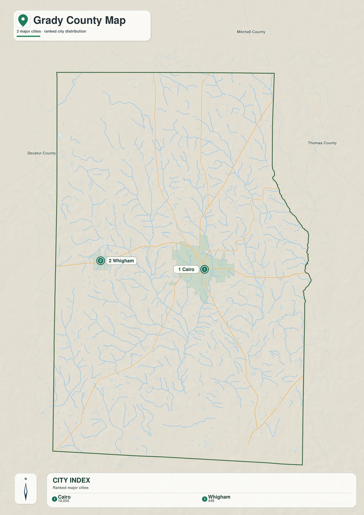
The city map removes most roads and local labels and highlights only Cairo and Whigham. Its CITY INDEX shows Cairo at 10,055 and Whigham at 449. Those figures are the values printed on the supplied map and are reproduced here to explain the ranking used by the graphic. They should not be treated as newly verified population estimates for this article; readers who need current official demographic figures can use the Census QuickFacts source below.
The map does not draw connector lines or give mileage between the two cities, so there is no reason to invent a distance. What it does show clearly is direction and scale. Cairo occupies the larger central-eastern developed area, while Whigham is a much smaller city to the west. On the general map, Route 38 provides the clearest visual connection between them. The city view is therefore most useful when the question is simply where the two principal incorporated places sit inside the county.
Decatur County, Mitchell County, and Thomas County are labeled outside the boundary for regional context. Those names are orientation aids rather than a legal survey product. The general county map also includes Calvary and Pawnee, so the two-city view should not be interpreted as a complete list of every named community. Its purpose is narrower: it isolates the major city distribution so Cairo’s central role and Whigham’s western position are easy to recognize.
The Tired Creek System and the Ochlockonee River
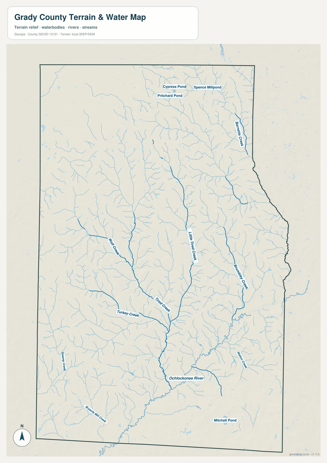
The water map gives the county a very different structure from the road map. The Ochlockonee River is the strongest named river in the southern part of the county. Several upstream channels converge toward the central and southern interior before the river continues toward the bottom of the map. Little Tired Creek follows a long route through the middle, and Tired Creek joins the broader drainage near the same central lowland. These channels create a clear north-to-south water framework even though no single large lake dominates the county.
Western tributaries provide more detail. Wolf Creek runs through the west-central area, Turkey Creek approaches the Tired Creek system from the southwest, and Swamp Creek is labeled farther south. Byrams Mill Creek appears close to the southwestern boundary. On the eastern side, Burntbridge Creek is a strong named channel, Walton Creek lies farther southeast, and Barnetts Creek follows part of the northeastern edge. The combination of these names makes it possible to describe different parts of Grady County by water rather than only by roads and towns.
Several small standing-water features are also labeled. Cypress Pond, Pritchard Pond, and Spence Millpond appear near one another in the northern part of the county, while Mitchell Pond is shown in the southeast. Smaller unnamed ponds and water polygons occur elsewhere. Their presence reinforces the impression of a landscape with numerous local drainage features rather than one dominated by a single reservoir or broad river floodplain.
This map is intended for county-scale water orientation. It does not establish flood-insurance status, property boundaries, stream depth, boating conditions, or legal water access. Property-level flood, access, or water-use decisions in Grady County should be checked against the relevant current agency or parcel source. For ordinary map reading, the useful task is to see how Little Tired Creek and Tired Creek connect with the larger southern drainage, where Wolf Creek and Burntbridge Creek sit, and how the Ochlockonee River occupies one of the lowest corridors in the county.
Elevation from About 32 to 110 Meters
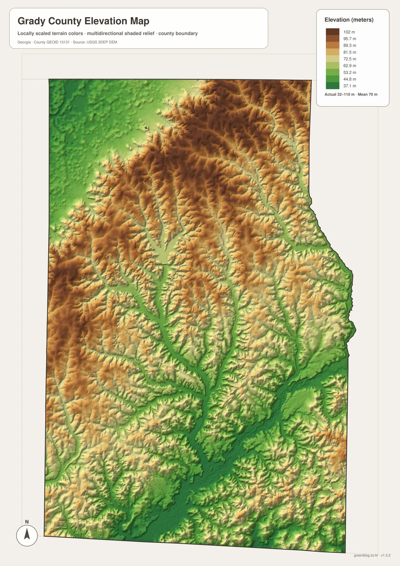
The elevation legend reports an actual range of approximately 32 to 110 meters, with a mean of 70 meters. Grady County is not mountainous, but the shaded relief still reveals a clear pattern. Higher tan and brown ground is concentrated across much of the north and northeast, with another belt of higher rolling terrain along the west. Lower green corridors spread through the center and south. The total range is modest compared with northern Georgia, yet the local differences are large enough to make drainage valleys easy to recognize.
The strongest low corridor matches the Tired Creek and Ochlockonee River system. Little Tired Creek descends through a green valley toward the central interior, Tired Creek enters the same broader low area, and the southern river corridor remains dark green. Burntbridge Creek and Walton Creek also occupy lower paths on the eastern side. Comparing the water and elevation maps is especially useful here because the named blue channels line up with the lowest parts of the terrain.
The north and northeast contain more continuous higher relief. Brown and tan ridges are broken by narrow green tributary valleys, creating a fine pattern of rolling ground. The western side around and beyond Whigham is also uneven, with short higher divides between creeks. This means the county should not be imagined as perfectly flat farmland. Even within a 32–110 meter range, streams have carved many small valleys and left gently higher ground between them.
The elevation map is designed for broad county comparison, not for surveying a building lot, engineering a road, or designing drainage. A building site or drainage project needs finer elevation information than this county-scale relief image can provide, and field measurements may also be necessary. For classroom geography, county orientation, or a presentation, however, the map clearly shows that northern and western ground is generally higher while the central and southern drainage corridors are lower.
Cairo, Rural Land, and the County’s 1905 Background
The supplied source article identifies Grady County as established in 1905 and describes diversified farming, food production, local industry, and the Florida-border region as parts of its rural economic background. The four maps on this page do not measure farm production or classify land cover, so they should not be used to infer crop acreage or agricultural percentages. What they do show is the geographic setting behind that rural description: Cairo as the main service and road center, Whigham farther west, broad areas without dense urban labels, and a county-wide network of small creeks.
The map choice should depend on the question. The general county view is the easiest place to start when roads, places, and the boundary all matter. The city map is cleaner for comparing Cairo and Whigham. The water map is the strongest reference for the Ochlockonee River, Tired Creek system, named tributaries, and ponds. The elevation view adds the low valleys and higher rolling divides that explain why so many blue stream lines appear across the county.
Cairo is particularly useful for connecting the themes. Routes 38 and 84 provide an east-west reference through the city, while Routes 93 and 112 help establish north-south direction. At the same time, several drainage branches pass through the surrounding countryside and lead toward the lower central and southern terrain. That relationship makes the map set useful for a geography lesson or local presentation because transportation and physical geography can be discussed using the same county boundary.
The downloadable files are useful when the webpage previews are too small for printing or presentation work. Each A3 JPG keeps one theme clear—county reference, city distribution, waterways, or elevation—without forcing every label onto a single crowded image. Because the four files use the same county outline, they can also be placed side by side in a report or slide deck for direct comparison.
Frequently Asked Questions
Which city serves as Grady County’s seat?
Cairo serves as Grady County’s seat and is also the strongest urban reference on the supplied general map, where several numbered routes meet around the city.
Which cities are emphasized on the city map?
The ranked city map emphasizes Cairo and Whigham. Its CITY INDEX shows Cairo at 10,055 and Whigham at 449, while the general map also labels places such as Calvary and Pawnee.
Which waterways are easiest to identify?
The Ochlockonee River, Little Tired Creek, Tired Creek, Wolf Creek, Turkey Creek, Burntbridge Creek, Walton Creek, and Barnetts Creek are among the clearest named features. Several ponds are also labeled in the northern and southeastern parts of the county.
What is included in the downloadable ZIP?
The ZIP provides four high-resolution A3 JPG originals: the Cairo-centered county reference, the Cairo–Whigham city view, the named-waterway map, and the 32–110 meter relief map. They share the same county outline but keep roads, settlements, water, and terrain in separate readable views.
Map File Information
Grady County A3 Map Files
- Included Files: 4 high-resolution A3 JPG map files shown in this article
- File Type: JPG files in a ZIP archive
- Intended Use: Printing, education, presentations, and map-based projects
Related Maps
Grady County Data and Local References
- Grady County official profile – county background and local information
- U.S. Census Bureau QuickFacts: Grady County – current official statistics
- New Georgia Encyclopedia: Grady County – county history and regional background
- Census TIGER/Line boundary files – source geometry for Grady County and surrounding county reference lines
- USGS hydrography resources – reference data for the Ochlockonee River, creeks, ponds, and connected surface water
- USGS 3DEP elevation resources – source elevation data used to compare Grady County’s low creek valleys and higher rolling ground
Green Map creates custom-edited map images using open geographic data sources such as geoBoundaries, Natural Earth, OpenStreetMap, and government open data. These maps are edited visual materials, not raw data files, and are provided for education, documents, presentations, and graphic reference.