Gordon County lies in northwestern Georgia, where Calhoun sits near a major north-south transportation corridor and broad river valleys are bordered by higher ridges on both sides of the county. The map set on this page separates those features so they remain easy to read. The general map shows Calhoun, Resaca, Fairmount, Plainville, Ranger, major roads, and the county boundary. The city map uses Calhoun as a hub for straight-line comparisons with Resaca, Plainville, and Fairmount. The water view names the Conasauga, Coosawattee, and Oostanaula rivers along with several creeks and lakes, while the elevation map shows an actual range of about 179 to 557 meters. After reviewing the previews, you can download four high-resolution A3 JPG maps in one ZIP.
Calhoun is the most useful place to start. It is the county seat, I-75 passes close to the city, and several routes branch outward toward the rest of Gordon County. Resaca lies north along the same broad corridor, Plainville is southwest, and Fairmount and Ranger are much farther east. That settlement pattern sits within a landscape that changes from low river country in the central and western interior to much higher ridges near parts of the western and eastern county edges. The water and elevation maps make those contrasts much clearer than a road-only view.
Table of Contents
Calhoun, I-75, and the County Road Framework
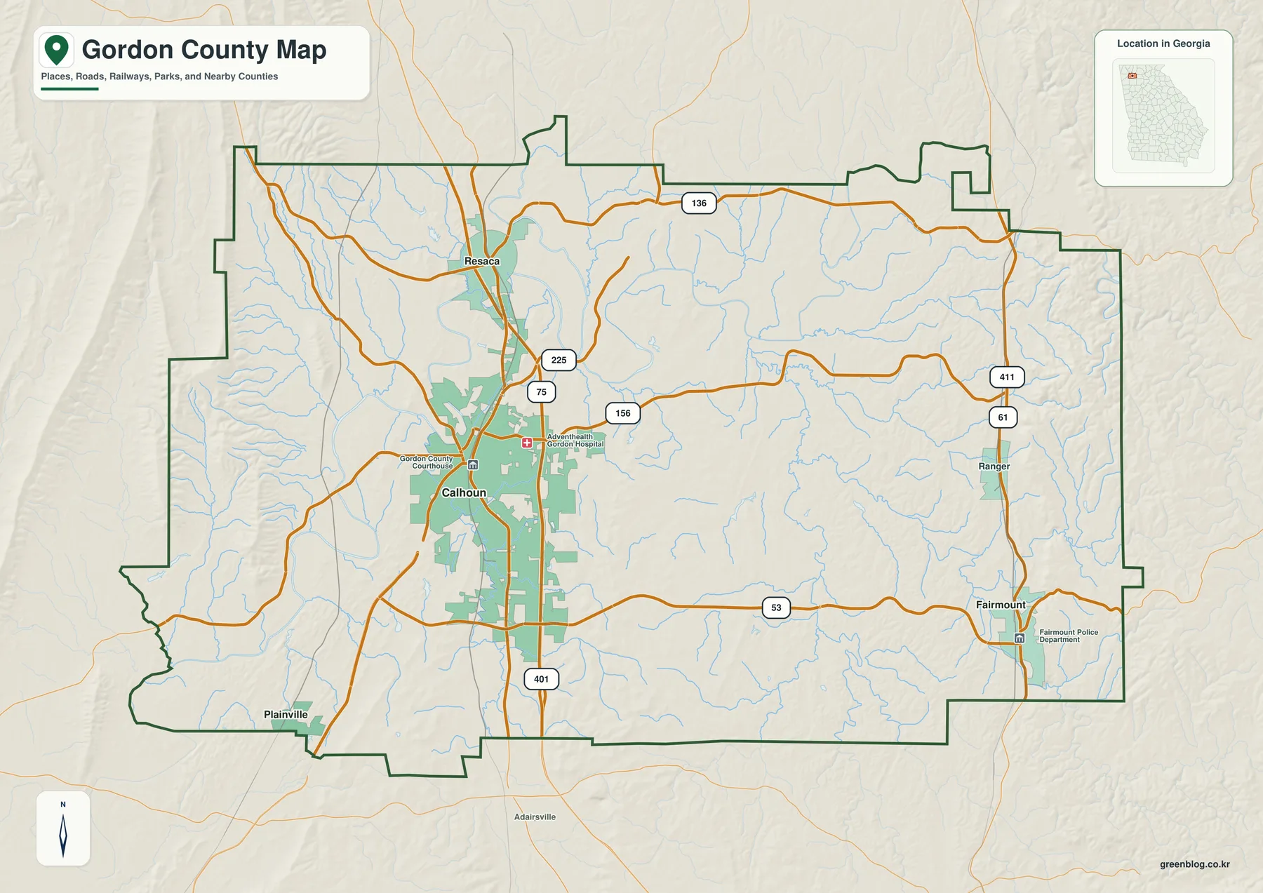
The general map places Calhoun slightly west of the county’s center, where the largest developed area and several major road connections are visible. The Gordon County Courthouse and AdventHealth Gordon Hospital are labeled nearby, reinforcing Calhoun’s role as the county seat and principal urban reference. I-75 runs north through the Calhoun area toward Resaca, where Route 225 provides another recognizable connection. Route 136 crosses the northern part of the county, Route 156 runs east of Calhoun, and Route 53 extends across the southern half. Ranger and Fairmount are tied to the eastern road network that includes Routes 61 and 411.
The places do not form an even ring around Calhoun. Resaca is relatively close to the north along the I-75 corridor, while Plainville sits near the southwestern edge. Fairmount is much farther east, and Ranger lies north of it in the eastern part of the county. That arrangement matters for map reading because travel between Calhoun and the eastern towns requires crossing the interior rather than simply following the interstate. The county map is most useful at this scale: it shows the broad direction of travel and the relationship among towns, roads, streams, and the boundary without trying to replace street-level navigation.
Water is already visible throughout the general map. Numerous thin blue tributaries cross the western side, the Calhoun area, and the hills around Ranger and Fairmount. Those streams help explain why many roads curve rather than forming a regular grid. They also foreshadow the terrain shown in the elevation map, where low drainage corridors lie between longer ridges. The general map is therefore a useful first view before the more specialized water and relief maps separate those features in greater detail.
Straight-Line Connections from Calhoun
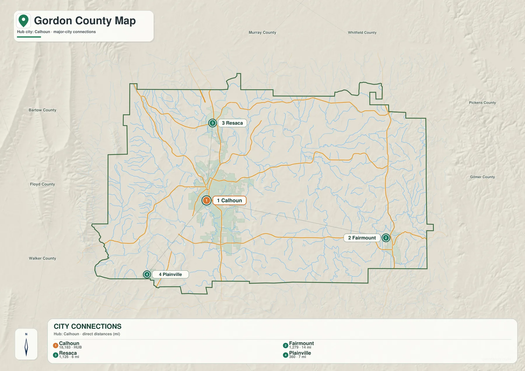
The city map removes most of the road labels and simplifies the county to four major place references. Its CITY CONNECTIONS panel lists Calhoun at 18,183, Fairmount at 1,279, Resaca at 1,126, and Plainville at 360. These are the values printed on the supplied city map and are included here to explain its visual ranking; they should not be treated as newly verified population estimates for this article. Readers who need current official figures can use the Census source listed below.
The connector distances are straight-line measurements, not driving mileage. Resaca is shown about 6 miles from Calhoun, Plainville about 7 miles, and Fairmount about 14 miles. Actual travel distance can be longer because the road network bends through valleys and around ridges. The comparison is still useful. Resaca and Plainville are relatively close to the Calhoun hub in opposite directions, while Fairmount is clearly separated on the eastern side of the county.
The map also includes neighboring county labels around Gordon County, including Murray, Whitfield, Pickens, Gilmer, Floyd, Walker, and Bartow. These labels provide regional orientation rather than legal survey information. Their main value is showing that Gordon County occupies a transitional part of northwestern Georgia, with Calhoun in the western-central interior and the Fairmount–Ranger side extending toward higher eastern terrain.
| Place | Displayed value | Straight-line distance from Calhoun |
|---|---|---|
| Calhoun | 18,183 | hub |
| Resaca | 1,126 | about 6 mi |
| Plainville | 360 | about 7 mi |
| Fairmount | 1,279 | about 14 mi |
Conasauga, Coosawattee, and Oostanaula River Valleys
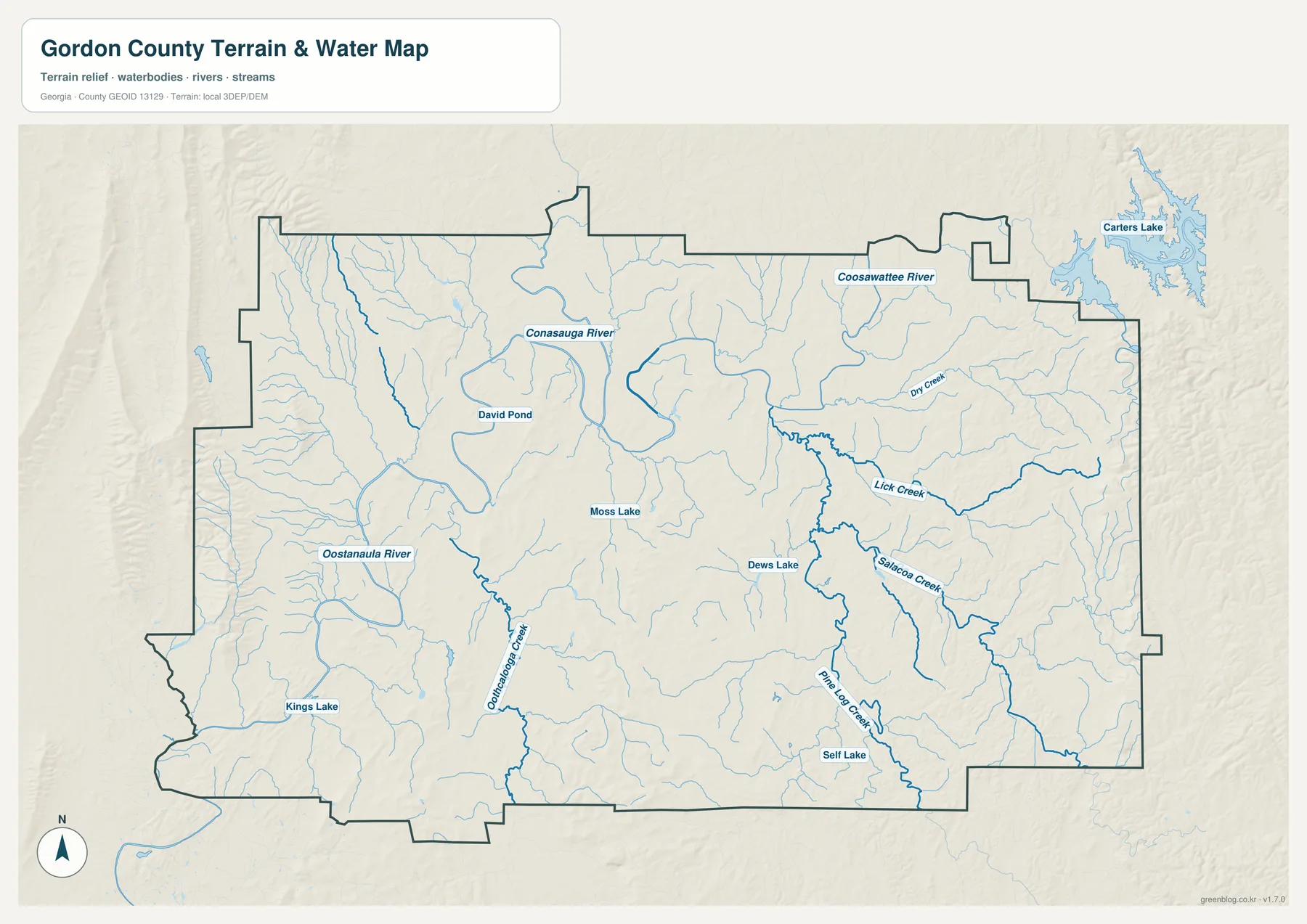
The water map changes the emphasis from transportation to valleys. The Conasauga River enters the broad northern and central part of the county, while the Coosawattee River is labeled across the northeastern side. Downstream, the Oostanaula River is a strong feature in the western and southwestern interior. Together, these names provide the main river framework for Gordon County. The general map makes Calhoun and I-75 look like the dominant organizing features; the water map shows that the same central area is also shaped by a major river system.
Several named creeks add detail between the major rivers and the county edges. Oothkalooga Creek runs through the western and south-central side near the Calhoun corridor. Lick Creek and Salacoa Creek occupy the eastern half, Pine Log Creek extends through the southeast, and Dry Creek is labeled farther northeast. Many unnamed tributaries branch into these waterways. Their density explains why the shaded-relief map contains so many narrow green channels between higher ridges.
Named standing-water features are distributed across the county. David Pond appears in the north, Moss Lake lies closer to the center, Dews Lake is in the eastern interior, Self Lake appears farther south, and Kings Lake is labeled in the southwest. Carters Lake is shown beyond the northeastern edge and provides a larger regional water reference. These features differ in size and purpose; on this page, their main value is geographic orientation within the stream network.
This map is intended for county-scale water reference rather than flood-insurance decisions, parcel boundaries, navigation depth, or legal shoreline questions. Those tasks require specialized and current official data. For ordinary map reading, the useful questions are simpler: where the three major rivers lie, which valleys contain Oothkalooga, Lick, Salacoa, or Pine Log Creek, and how the smaller tributaries connect the higher terrain to the broad central river system.
Elevation from About 179 to 557 Meters
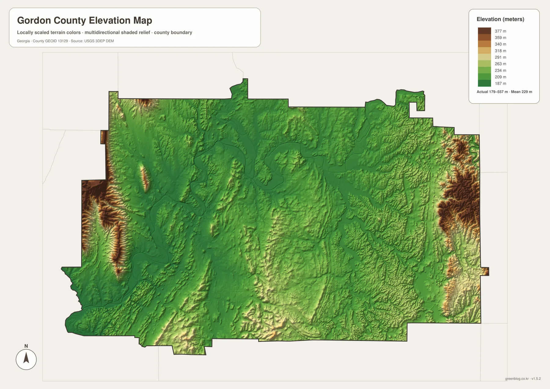
The elevation map reports an actual range of approximately 179 to 557 meters, with a mean of 229 meters. Much of the central and north-central county appears green, indicating relatively low terrain. The strongest high relief occurs along parts of the western edge and the far eastern side, where tan, brown, and dark-brown ridges rise sharply above the interior. The difference is large enough to give Gordon County a clear ridge-and-valley appearance even without naming a formal physiographic region.
The river corridors help explain the broad low interior. When the Conasauga, Coosawattee, and Oostanaula paths from the water map are compared with the elevation colors, they align with lower terrain. Calhoun also occupies this lower central-western setting rather than one of the highest ridges. This relationship makes the road network easier to understand: the strongest transportation corridor and principal city lie within terrain that is generally lower and more open than the steep ridges along parts of the county edges.
The southern and southeastern sections are more varied. Rolling tan hills rise above creek valleys associated with Lick Creek, Salacoa Creek, and Pine Log Creek. The west contains several long, narrow ridges separated by green drainage lines. The far east rises sharply again. Gordon County therefore cannot be reduced to a simple high-east/low-west description. A broad low river corridor forms the central framework, but local ridges and creek valleys repeat across the entire county.
The elevation colors and hillshade are designed for broad county-wide comparison. They are not survey-grade measurements for a building site, road project, drainage plan, or construction design. Exact site elevations require more detailed data and, where appropriate, field measurement. For classroom geography, local orientation, or a presentation, however, the 179–557 meter range provides a clear visual explanation of the low river valleys and higher surrounding ridges.
Calhoun, Resaca, and the County’s Historical Setting
The supplied source article identifies Gordon County as established in 1850 and Calhoun as the county seat. It also points to Cherokee history, New Echota, and Civil War sites as important parts of the county’s regional background. The four maps on this page are not detailed historic-site maps, so they should not be used to define the boundaries of New Echota or a battlefield. Their value is providing the geographic framework around those subjects: Calhoun and Resaca, the I-75 corridor, the major rivers, and the ridge-and-valley terrain.
Resaca lies north of Calhoun near the I-75 and Route 225 area, while Fairmount and Ranger occupy a very different eastern setting among more strongly ridged terrain. Plainville provides a southwestern reference. When these locations are combined with the river and elevation maps, the county’s historical place names become easier to position within the modern landscape. A reader studying local history can first identify the towns and natural corridors, then turn to the dedicated historical source for site-level detail.
The most useful map depends on the question. The general map is the best first choice for cities, main roads, and the county outline. The city map provides a cleaner comparison of Calhoun, Resaca, Plainville, and Fairmount. The water map is the right view for the three major rivers and named creeks, while the elevation map shows how those waterways occupy lower corridors between ridges. Because all four share the same county boundary, they can be compared side by side without forcing every road, water label, and terrain cue into one crowded image.
Frequently Asked Questions
What is the county seat?
Calhoun is the county seat of Gordon County. The courthouse is labeled near the city on the general map, and the city-connections view also uses Calhoun as its hub.
Are the city-map distances driving distances?
No. The map shows straight-line distances from Calhoun: about 6 miles to Resaca, 7 miles to Plainville, and 14 miles to Fairmount. Actual road mileage depends on the route and can be longer.
Which rivers and creeks are labeled on the water map?
The water view labels the Conasauga River, Coosawattee River, and Oostanaula River, along with Oothkalooga Creek, Lick Creek, Salacoa Creek, Pine Log Creek, Dry Creek, and several named lakes and ponds.
What is included in the downloadable ZIP?
The archive contains four high-resolution A3 JPG files: a general Gordon County map, a city-connections map, a water map, and an elevation map. Each file emphasizes a different part of the same county.
Map File Information
Gordon County A3 Map Files
- Included Files: 4 high-resolution A3 JPG map files shown in this article
- File Type: JPG files in a ZIP archive
- Intended Use: Printing, education, presentations, and map-based projects
Related Maps
Sources and Reference Material
- U.S. Census Bureau QuickFacts: Gordon County – current official statistics
- New Georgia Encyclopedia: Gordon County – county history and regional background
- New Georgia Encyclopedia: Calhoun – background on Calhoun
- U.S. Census Bureau TIGER/Line Shapefiles – county boundary and geographic reference data
- USGS National Hydrography – river, stream, and water-feature data
- USGS 3D Elevation Program – elevation data
Green Map creates custom-edited map images using open geographic data sources such as geoBoundaries, Natural Earth, OpenStreetMap, and government open data. These maps are edited visual materials, not raw data files, and are provided for education, documents, presentations, and graphic reference.