Glynn County sits on Georgia’s Atlantic coast, where Brunswick is surrounded by tidal rivers, sounds, marshes, and island shorelines rather than by one simple land boundary. The four maps on this page separate those features so they remain readable. The general map shows Brunswick, Sterling, Dock Junction, St. Simons, Jekyll Island, and major roads. The city map simplifies the county to its principal ranked city. The water view names the South Altamaha, Mackay, Hampton, Turtle, and Little Satilla rivers along with Doboy Sound and St Simons Sound. The elevation map reports an actual range of about -2 to 21 meters with a mean of 3 meters. After reviewing the previews, you can download four high-resolution A3 JPG originals in one ZIP for printing, classroom use, presentations, or local research.
Brunswick is the easiest anchor for understanding the county. Dock Junction and Sterling lie to the north, St. Simons is across the tidal water to the east, and Jekyll Island extends along the coast to the southeast. Roads 95, 405, 303, and 84 are easy to recognize around the Brunswick area, while 17, 25, 32, 99, 341, and 27 provide northern references. Yet the road map tells only half the story. The eastern half of Glynn County is divided by broad sounds and narrow tidal channels, and the low-elevation view shows how extensive those coastal flats are. The county therefore reads most clearly when roads, water, and relief are compared rather than treated as separate subjects.
Table of Contents
Brunswick, St. Simons, Jekyll Island, and the Main Roads
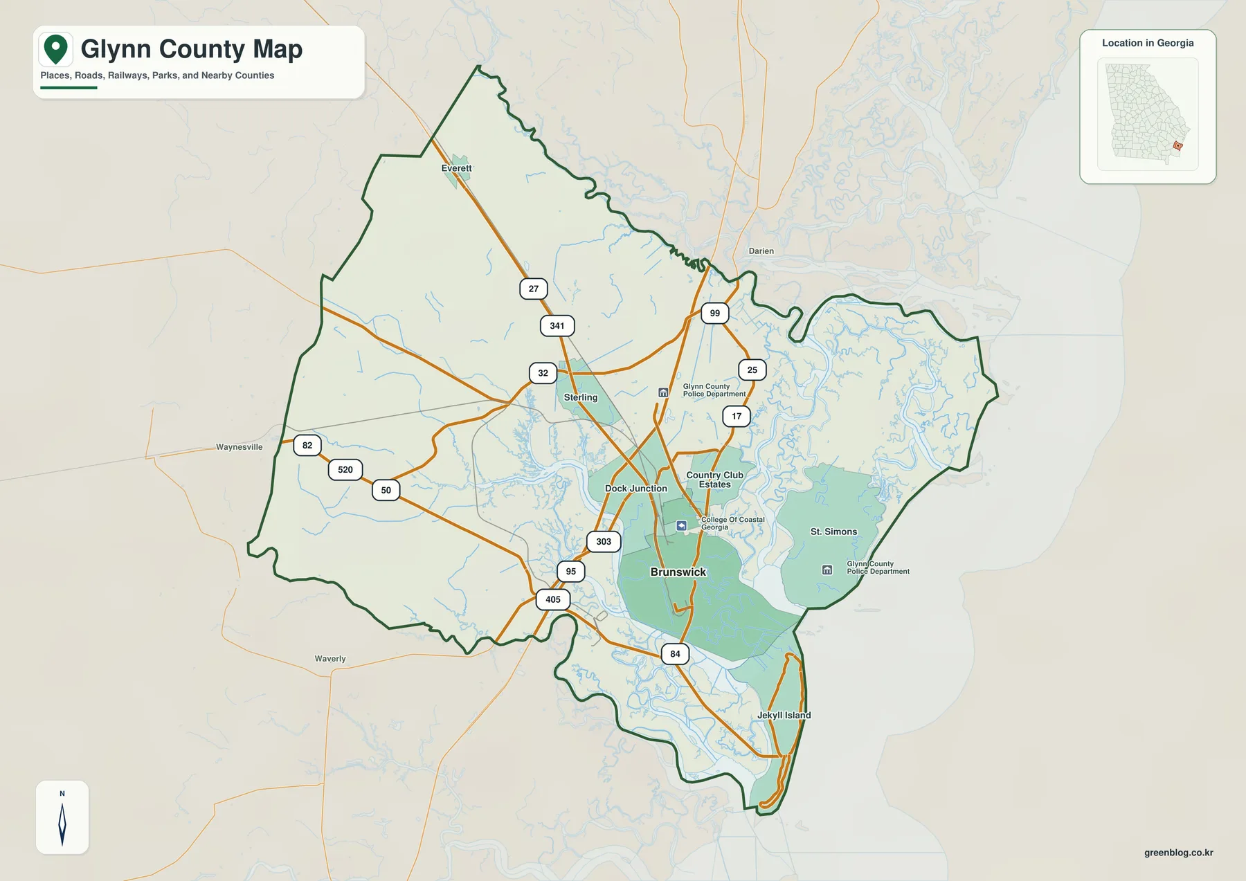
The general map places Brunswick in the southeastern part of the mainland county. Dock Junction appears immediately north of the city, with Sterling farther north. St. Simons lies across a broad marsh-and-water area to the east, while Jekyll Island forms a long coastal strip to the southeast. Everett is labeled in the northern mainland section. Outside the boundary, Darien, Waynesville, and Waverly provide useful regional reference points, helping a reader place Glynn County within the larger southeastern Georgia coast.
Road labels are densest around Brunswick. Routes 95 and 405 create strong north-south references, and 303 links the Brunswick and Dock Junction area. Route 84 continues toward the southern coastal section and the approach to Jekyll Island. North of the city, 17, 25, 99, 32, 341, and 27 spread through the mainland, while 82, 520, and 50 appear farther west. These labels are useful for county-scale orientation rather than turn-by-turn navigation. Their main value is showing how the Brunswick urban area connects with the northern mainland and the island-facing coast.
College of Coastal Georgia is marked northeast of central Brunswick, and county police facilities are also labeled on the map. They serve as location anchors rather than a complete directory of institutions. More important is the relationship between development and water. Brunswick, St. Simons, and Jekyll Island are separated by broad marshes, river channels, and sounds, so a short straight-line gap can represent a much more complex physical landscape. The general map introduces that relationship, and the dedicated water map makes it unmistakable.
A City Map Focused on Brunswick
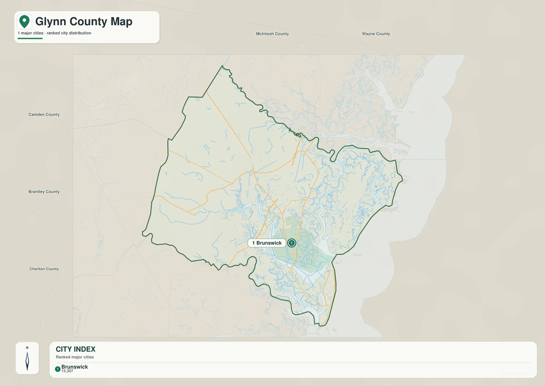
The city map is deliberately simple. Its CITY INDEX lists Brunswick at 15,307 and does not rank additional cities. That figure is reproduced from the supplied map to explain its internal ranking and should not be treated as a newly verified population estimate for this article. Readers who need current official demographic data can use the U.S. Census Bureau QuickFacts source listed below.
A one-city display does not mean the county lacks other important places. Sterling, Dock Junction, St. Simons, Jekyll Island, Everett, and other local references appear on the general map. The city view simply removes much of the road and water detail so Brunswick can be located instantly. It is most useful when a presentation or classroom activity needs the county seat and principal urban reference without the visual complexity of the coastal waterways.
Neighboring counties appear around the map as context: McIntosh to the north, Wayne to the northwest and north, Brantley to the west, and Camden and Charlton farther southwest. These labels are for regional orientation rather than legal boundary surveying. They make it clear that Brunswick lies near the southeastern coast of the county while a large mainland area remains to the west and north.
South Altamaha River, Sounds, and the Tidal Network
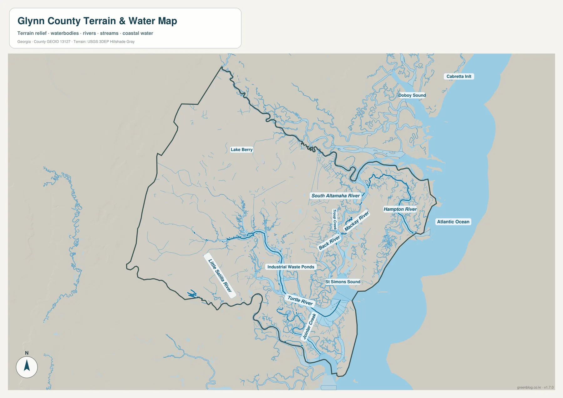
The water map is the clearest expression of what makes Glynn County different from an inland county. The Atlantic Ocean forms the outer eastern edge, but the coastline is separated from the mainland by a broad maze of rivers, sounds, marsh channels, and islands. South Altamaha River is labeled across the northern coastal section. Doboy Sound and Cabretta Inlet appear farther east, where the water network opens toward the ocean. These features create a boundary that is shaped by water at many scales rather than by one shoreline.
Around Brunswick and St. Simons, several large named channels provide better local reference. Mackay River and Hampton River divide portions of the island-and-marsh landscape, while Turtle River and St Simons Sound define major waters south and east of Brunswick. Back River and Clubb Creek add smaller named channels nearby. The map also labels Joining Creek farther south toward the Jekyll Island side. Reading these names together explains why the Brunswick–St. Simons area cannot be understood as two land points separated by one river.
The mainland has water references as well. Little Satilla River runs along the southwestern side of the county, and Lake Berry is labeled farther north. Industrial Waste Ponds appear south of Brunswick as another named water feature on the supplied map. These features differ greatly in size and character; the map uses them simply as geographic reference points. Numerous unnamed tributaries and tidal channels fill the spaces between the labeled rivers and sounds.
This water view is intended for county-scale geographic orientation. It does not determine flood-insurance zones, navigation depth, tidal timing, property boundaries, or legal boating access. Those questions require specialized and current official data. For a map page, the main value is seeing where the major river and sound names sit, how the coast is divided into marsh channels, and how Brunswick, St. Simons, and Jekyll Island fit within that network.
An Elevation Range of About -2 to 21 Meters
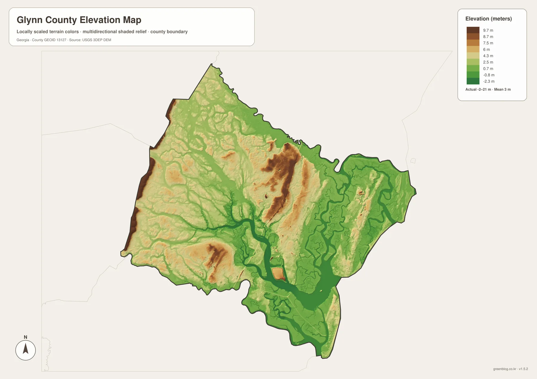
The elevation legend reports an actual range of approximately -2 to 21 meters and a mean of 3 meters. Most of the county is therefore very low compared with inland and mountain counties. Green colors dominate the marshes, tidal corridors, and much of the eastern and southern landscape. The low values are especially widespread around the Brunswick–St. Simons water system and along the many channels that cut into the county from the coast.
Higher ground is still visible. The western boundary and several parts of the west-central mainland contain tan and brown areas, and a few elongated higher zones appear closer to the middle of the county. With a maximum near 21 meters, these are not mountain ridges, but they stand out clearly against the very low marsh and channel network around them. The contrast helps a reader distinguish slightly raised mainland terrain from the broad coastal flats.
The water map makes those colors easier to interpret. South Altamaha River, Mackay River, Turtle River, and the numerous tidal channels occupy extensive green lowlands. St. Simons and Jekyll Island are also surrounded by low coastal terrain rather than high relief. The relationship between water and elevation is therefore unusually direct: much of the county’s visual structure comes from small differences in height across a very low coastal landscape.
The elevation view is designed for broad county comparison, not for determining the exact elevation of a building site, coastal flood risk, engineering design, or parcel-level drainage. Those tasks require more detailed elevation and hazard data. For general geography, however, the -2 to 21 meter range and 3 meter mean provide a clear summary of why marshes and tidal channels occupy such a large part of Glynn County.
Why Water Shapes the County More Than the Road Grid
The map set becomes most useful when the views are compared. The general map establishes Brunswick and the road network, then places Sterling, Dock Junction, St. Simons, and Jekyll Island around it. The city map reduces the picture to Brunswick alone. The water map reverses the emphasis by making rivers, sounds, marshes, and ocean water the dominant features. Finally, the elevation map shows that most of those water corridors occupy an extremely low landscape.
For a basic county-location slide, the general map is the clearest choice because it includes the widest range of place and road labels. The city map works when Brunswick needs to be highlighted without coastal detail. A project about the Atlantic coast, tidal rivers, sounds, or barrier-island setting benefits from the water view, while the elevation map is the better tool for explaining how little vertical relief separates mainland ground from marsh and tidal corridors.
The existing source article identifies Glynn County as established in 1777 and describes Brunswick, barrier islands, marshes, tourism, shipping, and coastal concerns as important parts of its background. The revised page keeps those ideas tied to visible map evidence: Brunswick’s road connections, the positions of St. Simons and Jekyll Island, the South Altamaha–Mackay–Turtle river system, the sounds along the coast, and the exceptionally low elevation range. These features make the county’s geography specific rather than generic.
The downloadable A3 files are useful when a project needs more detail than the webpage previews can provide. Each JPG keeps one focus—county reference, city distribution, water, or elevation—while preserving the same county boundary. That makes it easier to compare the maps in a report, classroom exercise, or presentation without forcing every road, water name, and terrain cue onto a single image.
Frequently Asked Questions
Why does the city map emphasize only Brunswick?
The supplied city map ranks Brunswick as the single major city and displays a CITY INDEX value of 15,307. The general map adds Sterling, Dock Junction, St. Simons, Jekyll Island, Everett, and other location references.
Which named waterways are easiest to identify?
The water map clearly labels South Altamaha River, Mackay River, Hampton River, Turtle River, and Little Satilla River. Doboy Sound, St Simons Sound, and Cabretta Inlet are additional coastal reference points.
What elevation range is shown for Glynn County?
The elevation legend states an actual range of about -2 to 21 meters and a mean of 3 meters. Tidal corridors and marshes are generally very low, while parts of the western mainland stand somewhat higher.
What is included in the downloadable ZIP?
The archive contains four high-resolution A3 JPG files: a general Glynn County map, a city map, a water map, and an elevation map. Each file emphasizes a different part of the same county geography.
Map File Information
Glynn County A3 Map Files
- Included Files: Four high-resolution A3 JPG maps: county, city, water, and elevation
- File Type: ZIP archive containing four JPG maps
- Intended Use: Printing, education, presentations, and map-based projects
Related Maps
Sources and Reference Material
- U.S. Census Bureau QuickFacts: Glynn County – current official statistics
- New Georgia Encyclopedia: Glynn County – county history and regional background
- U.S. Census Bureau TIGER/Line Shapefiles – county boundary and geographic reference data
- USGS National Hydrography – river, stream, and water-feature data
- USGS 3D Elevation Program – elevation data
Green Map creates custom-edited map images using open geographic data sources such as geoBoundaries, Natural Earth, OpenStreetMap, and government open data. These maps are edited visual materials, not raw data files, and are provided for education, documents, presentations, and graphic reference.