Glascock County is a small east-central Georgia county where Gibson serves as the county seat and Mitchell and Edge Hill appear as the other principal place labels on the supplied maps. Although the county has only a few emphasized settlements, the landscape is not visually simple. Roads cross a dense network of creeks, small ponds sit among rolling hills, and the elevation view shows a clear difference between higher northeastern ground and lower central and southwestern valleys. This page separates those features into four readable views. After reviewing them, you can download four high-resolution A3 JPG originals in one ZIP for printing, classroom work, presentations, or local research.
Gibson is the easiest place to use as a reference. Mitchell lies to the west, Edge Hill lies to the south, and the city map shows both at about 6 miles straight-line distance from Gibson. Route 123 provides a clear westward connection between Gibson and Mitchell, Route 102 continues south from the Mitchell area, and Route 171 passes near Edge Hill. In the northeast, Routes 80 and 296 form another recognizable road reference. Once the water and elevation maps are added, the county becomes easier to understand as a landscape of short ridges and creek valleys rather than simply three place names inside a boundary.
Table of Contents
Gibson, Mitchell, Edge Hill, and the Main Road Pattern
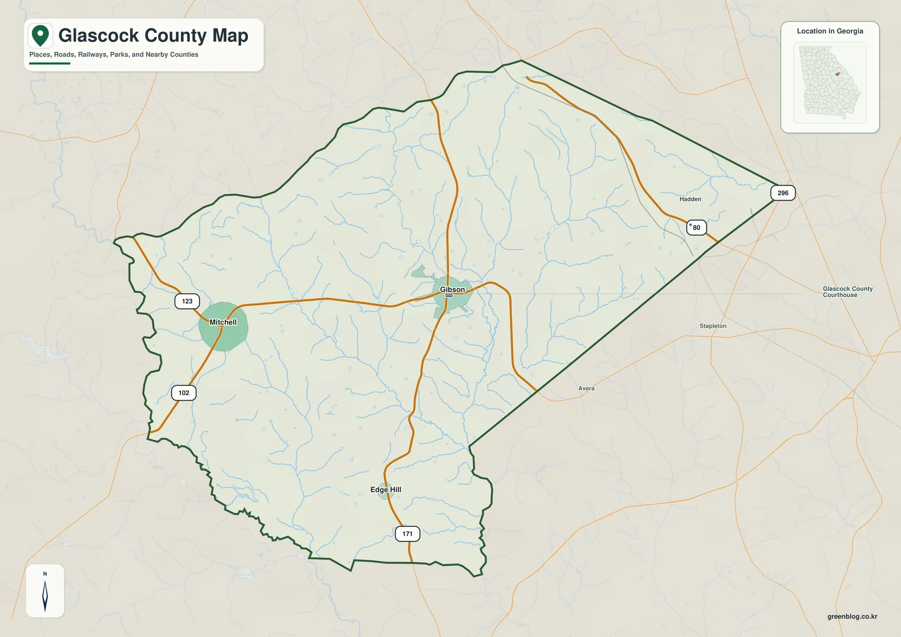
The general map places Gibson near the middle of the county, with the Glascock County Courthouse label close to the town center. Mitchell appears to the west as a second developed cluster, and Edge Hill is marked much farther south. Route 123 is the most obvious west-east road between Mitchell and Gibson. Route 102 drops south from the Mitchell side, while the road passing Edge Hill continues toward the Route 171 label near the southern boundary. In the northeastern triangular section, Routes 80 and 296 provide another pair of easy-to-find reference points.
Several places outside the county help establish regional position. Hadden is labeled to the east and northeast, Stapleton appears east of the county, and Avera lies southeast. These labels show how the numbered roads continue beyond the boundary rather than ending at the county line. Inside Glascock County, however, the settlement pattern remains sparse. The existing source article identifies the county as established in 1857 and describes agriculture, forestry, and small rural communities as part of its background. The wide spaces between Gibson, Mitchell, and Edge Hill fit that rural county setting.
Streams are visible throughout the general map even though most are not named there. Thin blue lines descend through the north and east, join larger channels around the center, and continue toward the southern edge. Similar drainage lines surround Mitchell and cross the broad rural area between the three place labels. This matters because the roads are not crossing a featureless plain. They pass through a landscape broken by small valleys, and those valleys become much easier to identify on the dedicated water and elevation maps.
A Gibson Hub with Mitchell and Edge Hill About 6 Miles Away
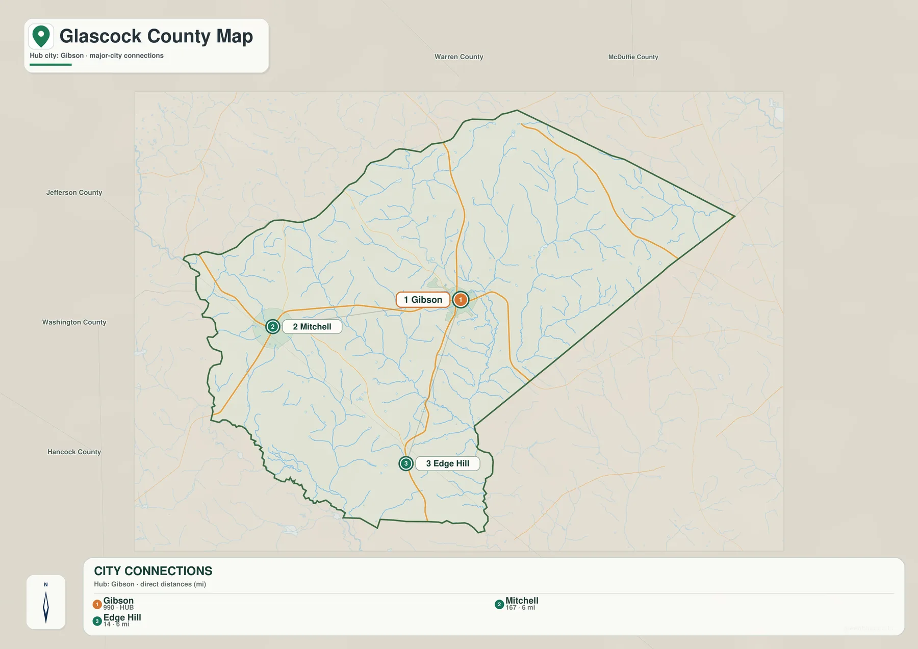
The city map removes most of the road and water detail and highlights three places. Its CITY CONNECTIONS panel lists Gibson at 990, Mitchell at 167, and Edge Hill at 14. Mitchell and Edge Hill are each shown about 6 miles from the Gibson hub. The mileage represents direct straight-line distance, not road mileage. Actual driving distance can be longer because roads bend through the countryside and do not follow the connector lines drawn on the map.
The arrangement is useful because the three labels point in different directions. Gibson is the central administrative reference, Mitchell sits to the west, and Edge Hill lies to the south. A reader who needs only that basic relationship can use the city map without the many stream lines and road numbers found on the general view. For travel orientation, however, the two maps work better together: Route 123 explains the Mitchell connection, while the southbound corridor through Edge Hill provides the second major direction from Gibson.
Neighboring counties are labeled around the city view as regional context. Warren and McDuffie counties appear across the northern and northeastern side, Jefferson lies east, Washington is to the west and southwest, and Hancock is shown farther south and west. These names are useful for understanding where Glascock County sits within east-central Georgia. They are not intended to replace a legal boundary survey, but they make the county’s small size and the central position of Gibson easier to judge.
| Place | Displayed value | Distance from Gibson on the city map |
|---|---|---|
| Gibson | 990 | hub |
| Mitchell | 167 | about 6 mi straight-line |
| Edge Hill | 14 | about 6 mi straight-line |
Rocky Comfort Creek, Deep Creek, and a Dense Small-Stream Network
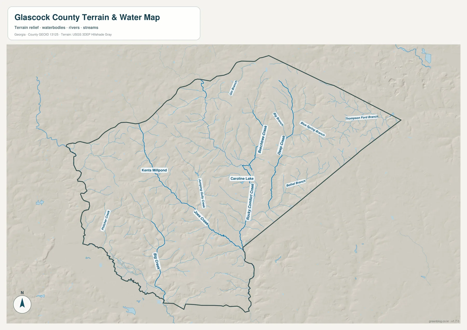
Rocky Comfort Creek is one of the strongest named features on the water map. It follows a long course through the central-eastern part of the county and continues toward the southern edge. Deep Creek runs in a broadly similar north-south direction farther east. Big Branch and Blue Spring Branch enter the same eastern drainage area from higher ground, while Thompson Ford Branch is labeled in the northeastern section and Bethel Branch appears farther south. These names make the water map much more informative than the general road view.
The western half has its own group of waterways. Jumping Gully Creek and Jones Creek run through the west-central and southern interior, and Big Creek forms another long reference closer to the southwestern boundary. Gin Branch is labeled in the northwestern half. The map also identifies Kents Millpond near the western side and Caroline Lake closer to the center. Together, these features show a county divided by many small drainage corridors rather than dominated by a single major river.
The relationship becomes clearer when the water and elevation maps are compared. Rocky Comfort Creek and Deep Creek occupy low green corridors, and the Jones Creek–Big Creek side of the county also follows lower terrain between ridges. Short tributaries descend from surrounding slopes into those larger channels. The stream network is therefore a useful guide to the shape of the land: the blue lines tend to follow the same valleys that the elevation map colors green.
This map is designed for county-scale water orientation. It does not determine flood-insurance status, property boundaries, channel depth, legal shoreline, or access rules. Those questions require specialized and current official sources. Here, the most useful task is to locate named creeks and branches, see how smaller tributaries join Rocky Comfort Creek and Deep Creek, and use Kents Millpond or Caroline Lake as local reference points within the county.
Elevation from About 80 to 180 Meters
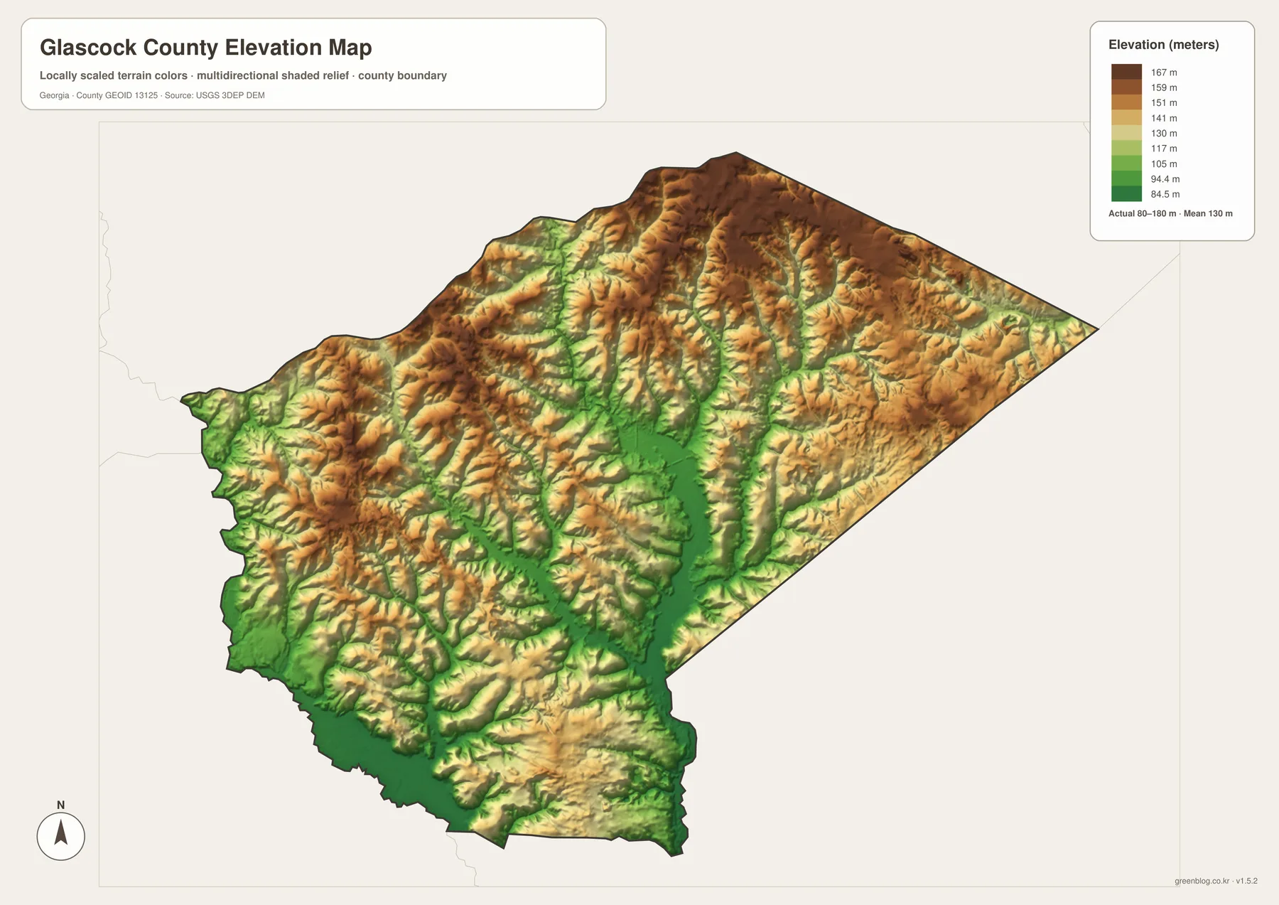
The elevation legend reports an actual range of about 80 to 180 meters, with a mean of 130 meters. This is not a mountain-county range, but the shaded relief still shows clear differences. Higher brown and tan ground is concentrated across much of the north and northeast. Lower green corridors spread through the center and southwest, especially where several named creeks and their tributaries converge. The result is rolling terrain with many short ridges rather than a broad flat plain.
The northeastern triangular section contains some of the most continuous higher ground. Narrow valleys cut into those ridges, matching the drainage lines labeled Big Branch, Deep Creek, Blue Spring Branch, and nearby tributaries on the water map. Farther south, the Rocky Comfort Creek corridor becomes a wider low area. This side-by-side comparison is useful because the road map alone does not make the height difference obvious.
The western side is generally lower than the highest northeast hills, but it remains uneven. Around Mitchell and toward the southwest, short tan ridges rise between green drainage corridors. Jones Creek and Big Creek occupy some of the lower paths. That rolling pattern helps explain why even a small rural county contains many bends in roads and streams and why the land between Gibson, Mitchell, and Edge Hill is more varied than the city map suggests.
The elevation colors are intended for broad county-wide comparison. They are not a substitute for survey measurements at a building site or for engineering work involving grading, drainage, or road design. More detailed elevation data and field measurement are appropriate for those tasks. For classroom geography, local orientation, or a presentation, however, the 80–180 meter range gives a clear visual explanation of higher hills and lower creek valleys.
A Small County with More Terrain Detail Than the City Count Suggests
Glascock County looks simple if only the city map is considered: Gibson sits near the center, with Mitchell and Edge Hill each about 6 miles away in different directions. The general map adds the road structure, while the water map shows that most of the open-looking land is crossed by streams and branches. The elevation view then reveals a network of low valleys between higher rolling ridges. Reading the four maps together therefore turns a three-place reference into a much fuller picture of the county.
The general county map is the best starting point when a reader needs Gibson, Mitchell, Edge Hill, major road numbers, and the county boundary in one image. The city view is cleaner for comparing the three place labels and their spacing. The water map is more useful for Rocky Comfort Creek, Deep Creek, Big Creek, named branches, and small standing waters. The elevation map is the clearest choice for explaining why those waterways follow green valleys through higher surrounding hills.
The existing source article identifies Glascock County as established in 1857 and describes agriculture, forestry, and small communities as part of the county’s rural background. The revised map page keeps that context tied to visible geography rather than repeating a generic rural description. Gibson’s road connections, Mitchell and Edge Hill, the dense creek network, and the 80–180 meter rolling relief provide specific map evidence for understanding how the county is organized.
The downloadable A3 files are useful when a project needs a larger image than the webpage previews. Each JPG keeps a different focus—general county reference, city distribution, waterways, or elevation—while preserving the same county boundary. That makes the set convenient for printing, reports, classroom comparison, or presentation slides without forcing every road, creek, place name, and relief cue onto one crowded map.
Frequently Asked Questions
What is the county seat?
Gibson is the county seat of Glascock County. The courthouse is labeled near Gibson on the general map, and the city map also uses Gibson as the hub for Mitchell and Edge Hill.
How far are Mitchell and Edge Hill from Gibson on the city map?
Both are shown at about 6 miles straight-line distance from Gibson. The connectors are geographic comparisons rather than driving routes, so actual road mileage can differ.
Which named waters appear on the water map?
The map labels Rocky Comfort Creek, Deep Creek, Big Creek, Jumping Gully Creek, Jones Creek, Big Branch, Blue Spring Branch, Kents Millpond, Caroline Lake, and several smaller branches.
What is included in the downloadable ZIP?
The archive contains four high-resolution A3 JPG files: a general Glascock County map, a city map, a water map, and an elevation map. Each file emphasizes a different part of the same county.
Map File Information
Glascock County A3 Map Files
- Included Files: General county map, city map, water map, and elevation map
- File Type: Four high-resolution A3 JPG files bundled in one ZIP archive
- Intended Use: Printing, education, presentations, and map-based projects
Related Maps
Sources and Reference Material
- U.S. Census Bureau QuickFacts: Glascock County – current official statistics
- New Georgia Encyclopedia: Glascock County – county history and regional background
- U.S. Census Bureau TIGER/Line Shapefiles – county boundary and geographic reference data
- USGS National Hydrography – river, stream, and water-feature data
- USGS 3D Elevation Program – elevation data
Green Map creates custom-edited map images using open geographic data sources such as geoBoundaries, Natural Earth, OpenStreetMap, and government open data. These maps are edited visual materials, not raw data files, and are provided for education, documents, presentations, and graphic reference.