Franklin County occupies a rolling part of northeastern Georgia where the county seat, the I-85 corridor, and the Broad River drainage system provide three different ways to understand the map. Carnesville sits near the interior as the administrative center, while Lavonia is farther northeast beside the interstate and serves as the hub on the supplied city-connections map. Royston, Franklin Springs, and Canon form a tighter group along the eastern and southeastern side. The page separates those settlement patterns from water and elevation so each map remains readable, and a ZIP with four high-resolution A3 JPG originals is available for download after the map previews.
The physical landscape is just as useful as the road network. The North Fork Broad River and Middle Fork Broad River follow separate valleys through the county before the drainage continues toward the Broad River in the south. Smaller streams fill the spaces between them, and the elevation map shows an actual range of roughly 162 to 299 meters with a mean of 229 meters. That is not mountain relief, yet the shaded surface clearly distinguishes lower river corridors from the repeated rolling ridges around them.
Table of Contents
Carnesville as the County Seat, Lavonia as the I-85 Gateway
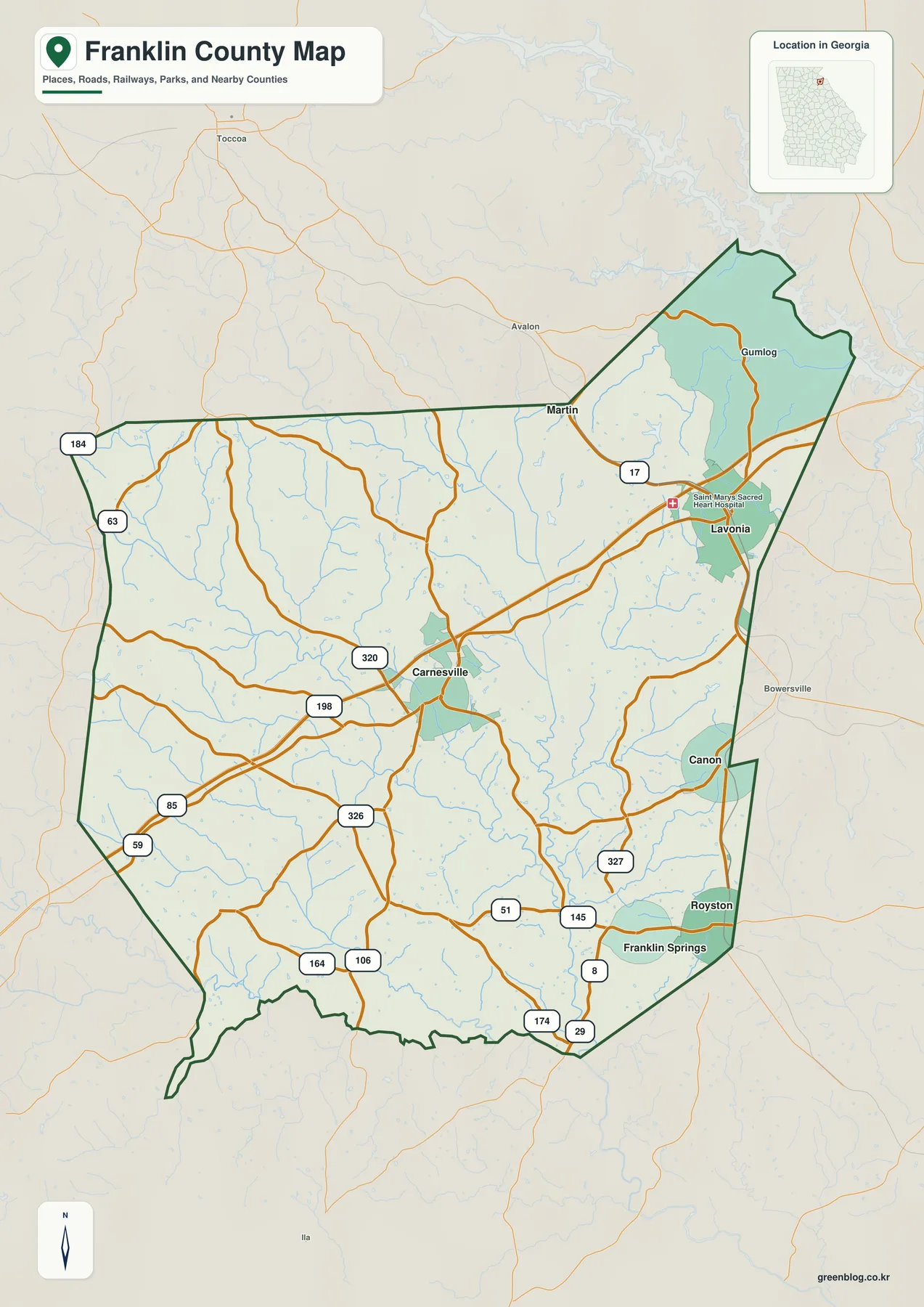
Carnesville is placed close to the county’s middle on the general map, where Routes 198 and 320 provide strong local references and Route 326 continues toward the south. The developed footprint around the county seat is visible, but it is smaller than the road concentration around Lavonia. Moving northeast, the map reaches I-85 and Route 17 near Lavonia, with Saint Mary’s Sacred Heart Hospital labeled nearby. This distinction matters: Carnesville explains the administrative geography, while Lavonia explains much of the county’s interstate access and eastern travel pattern.
The eastern side contains several municipalities within a relatively short map distance. Canon sits near the east boundary, and Royston and Franklin Springs appear farther south in close proximity. The western half has fewer major city labels and is instead defined by numbered roads such as 184, 63, 85, and 59, along with many thin stream lines. This uneven distribution helps explain why a county-seat-centered view and a transportation-centered view do not produce the same mental map of Franklin County.
The northeastern edge is also visually distinct because a large branching water body repeatedly cuts into the boundary. Gumlog and Martin are shown near this section, while Toccoa, Avalon, and Bowersville appear outside the county as useful regional references. The live WordPress source identifies Lake Hartwell access as part of the county’s local context. The maps on this page can help locate that water-shaped edge, but they are not intended to define legal shorelines, water depth, or navigation conditions.
Five City Labels Organized from a Lavonia Hub
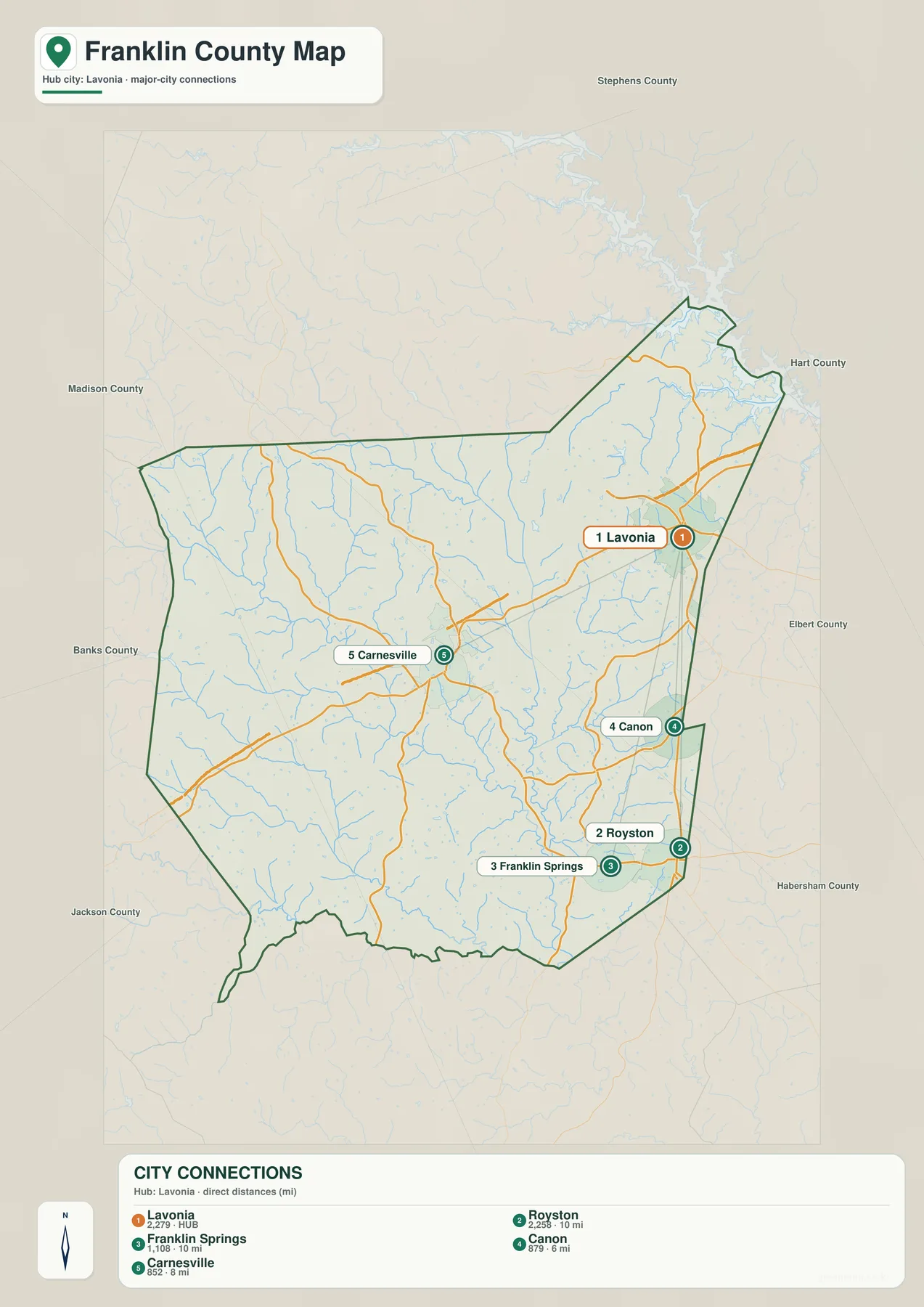
The city map intentionally changes the reference point from the county seat to Lavonia. Direct lines connect the hub to Canon, Carnesville, Royston, and Franklin Springs. The labels show about 6 miles to Canon, 8 miles to Carnesville, and 10 miles to both Royston and Franklin Springs. These are straight-line distances, not driving mileage. A real road trip may be longer because highways and local streets curve through the landscape and connect at different junctions.
The CITY CONNECTIONS panel also lists Lavonia at 2,279, Royston at 2,258, Franklin Springs at 1,108, Canon at 879, and Carnesville at 852. Those values are reproduced from the supplied map so readers can understand the ranking used by the graphic; they are not presented as a fresh demographic calculation. Current official population statistics should be checked through the Census source below. Visually, the map gives Lavonia and Royston the strongest emphasis while still showing Carnesville’s separate role as the county seat.
The arrangement also makes the eastern concentration of municipalities obvious. Lavonia is in the northeast, Canon sits below it near the eastern boundary, and Royston and Franklin Springs occupy the southeast. Carnesville is farther inland and west of that cluster. For a classroom or presentation, the city map is a clean way to explain that municipal geography without the many road numbers and small water features shown on the general county map.
| City | Displayed map value | Straight-line distance from Lavonia |
|---|---|---|
| Lavonia | 2,279 | hub |
| Royston | 2,258 | about 10 mi |
| Franklin Springs | 1,108 | about 10 mi |
| Canon | 879 | about 6 mi |
| Carnesville | 852 | about 8 mi |
Two Broad River Forks Across a Dense Creek Network
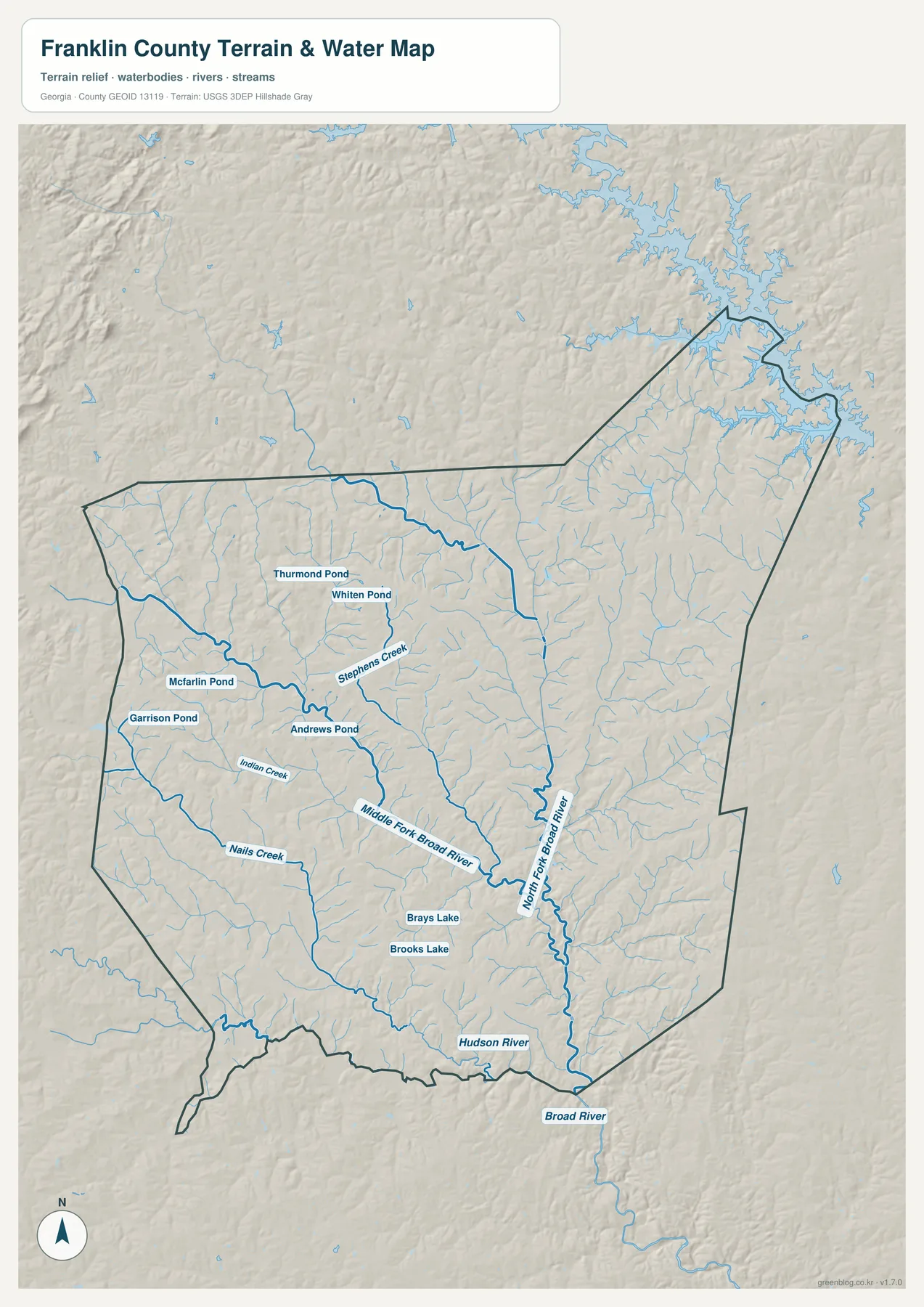
The water map changes the county from a road network into a system of valleys. The North Fork Broad River is one of the longest named channels on the eastern side of the interior, while the Middle Fork Broad River follows a separate course farther west. In the southern portion of the map, the Broad River label appears as the drainage continues out of the county, and Hudson River provides another named reference near the southern boundary. This layout is useful because it shows several long water corridors rather than one river dominating the entire county.
Smaller streams fill the gaps between the major river labels. Stephens Creek is prominent in the west-central area, and Indian Creek and Nails Creek appear farther south. Many unnamed tributaries branch toward these channels, so the apparently open spaces on the road map become much more detailed in the water view. For local-history research or a geography assignment, the named streams can serve as practical location references when a place is described by its river or creek rather than by a highway.
Ponds and small lakes add another layer of local detail. Thurmond Pond and Whiten Pond are labeled in the northwestern half, while Mcfarlin Pond and Garrison Pond are farther west. Andrews Pond lies closer to the center-west. Brays Lake and Brooks Lake appear in the southern interior, where several drainage lines converge. The map does not imply that these water bodies have the same size, public access, or use; it simply records named waters that can help a reader orient within the county.
The branching water surface at the northeastern boundary is also more understandable in this view than on the road map. Coves and incoming streams create a jagged edge rather than a simple straight line. This county-scale map should not be used for flood-insurance decisions, parcel boundaries, boating depth, or legal shoreline interpretation. Those questions require specialized current data. Its strength is geographic orientation: following the North Fork, Middle Fork, Broad River, and smaller creeks through the same county outline.
Rolling Relief Between 162 and 299 Meters
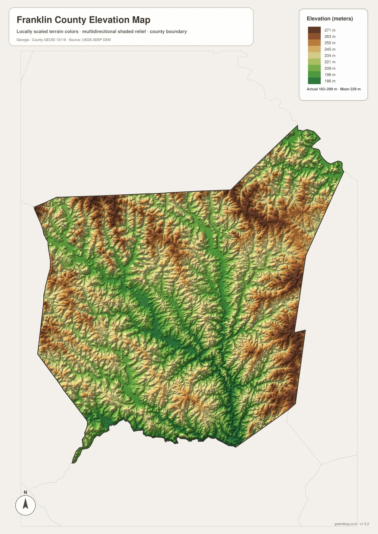
The elevation map reports an actual range of approximately 162 to 299 meters and a mean of 229 meters. Franklin County is therefore not a high-mountain landscape, but the shaded relief shows that it is far from flat. Brown and tan ridges appear repeatedly across the north, northeast, and parts of the west. Long green corridors cut between them through the middle and south, marking lower ground that often matches the river and creek network seen on the water map.
The North Fork Broad River provides a clear example of this relationship. Its route through the central-eastern part of the county aligns with lower green terrain, while nearby hills rise into yellow and brown. The Middle Fork Broad River follows another low corridor farther west. Toward the south, the Broad River and Hudson River lie where lower ground gathers again. Comparing the two maps turns what looks like a collection of colored lines into an understandable ridge-and-valley pattern.
The northeastern extension is especially textured. Higher slopes rise behind the water-cut boundary, but narrow tributary valleys repeatedly break those ridges. The western half has the same general character on a smaller scale, with short rolling divides between streams. This helps explain why a short straight-line distance between two cities does not describe the full landscape between them; roads and communities occupy terrain divided by many small rises and drainage corridors.
The elevation colors are meant for county-wide comparison, not for engineering or surveying a specific property. They do not replace a site elevation survey, grading plan, drainage study, or construction-grade terrain model. When the goal is to show which parts of Franklin County are relatively high and where river valleys are lower, however, the 162–299 meter range and shaded relief provide a clear and accessible overview.
From a 1784 County Seat to a Modern Interstate Corridor
The live WordPress article identifies Franklin County as having been established in 1784 and notes agriculture, poultry, I-85, Lake Hartwell access, and small-town services as parts of its local context. Those points are useful background, but the four maps on this page do not attempt to show farm acreage, poultry facilities, or economic activity. Their purpose is to establish the geographic framework beneath those topics: where Carnesville and the eastern municipalities are located, which roads cross the county, where water drains, and how the ground rises and falls.
That framework also shows why I-85 and the county seat describe different parts of daily geography. Lavonia is tied directly to the interstate corridor in the northeast, while Carnesville lies farther inland as the administrative center. Royston, Franklin Springs, and Canon form additional small centers along the eastern and southeastern side. A reader comparing roads and city labels can therefore see a network of several communities rather than one dominant urban core filling the county.
Choosing a Map for Roads, Cities, Water, or Terrain
The general county map is the most useful first choice when a project needs Carnesville, Lavonia, major route numbers, surrounding places, and the county boundary in one view. If the question is specifically about the spacing of the five labeled municipalities, the city-connections map is cleaner because it removes much of the extra detail and adds direct distances from Lavonia. Those distances work well for comparison, but they should not be presented as driving mileage.
For physical geography, the water and elevation views work together. The water map identifies the North Fork and Middle Fork Broad River, Hudson River, Stephens Creek, ponds, and many tributaries. The elevation map explains why those streams follow the routes they do by showing lower valleys between higher rolling ridges. A report about settlement can rely more heavily on the first two maps, while a lesson about the landscape can emphasize the latter pair.
The web previews are convenient for quick comparison, but printed material and presentation slides may require larger source images. The download below contains the four original A3 JPG maps in one archive. Because each file keeps a separate focus, a reader can select only the map needed for a project or place several views side by side to compare Franklin County’s settlements, water system, and terrain.
Frequently Asked Questions
Why does the city map use Lavonia instead of the county seat?
Carnesville is the county seat, but the supplied city-connections map uses Lavonia as its hub. Lavonia is positioned near I-85 and provides a convenient reference for comparing the eastern municipalities, while Carnesville remains the administrative reference on the general county map.
Are the mileage labels on the city map driving distances?
No. They are straight-line distances from Lavonia: about 6 miles to Canon, 8 miles to Carnesville, and 10 miles to Royston and Franklin Springs. Actual road mileage depends on the route used.
Which waterways give the clearest picture of the county?
The North Fork Broad River and Middle Fork Broad River are the strongest interior references. The Broad River and Hudson River appear in the south, while Stephens Creek, Indian Creek, Nails Creek, and several named ponds add more local detail.
What elevation range is shown on the relief map?
The map states an actual range of about 162 to 299 meters and a mean of 229 meters. It is useful for comparing lower stream valleys with higher rolling ground, but it is not a survey-grade elevation source for a specific property.
Map File Information
Franklin County A3 Map Files
- Included Files: 4 high-resolution A3 JPG map files shown in this article
- File Type: JPG files in a ZIP archive
- Intended Use: Printing, education, presentations, and map-based projects
Related Maps
Sources and Reference Material
- Franklin County official profile – county history and local background
- U.S. Census Bureau QuickFacts: Franklin County – current official statistics
- New Georgia Encyclopedia: Franklin County – county history and regional context
- U.S. Census Bureau TIGER/Line Shapefiles – boundary and geographic reference data
- USGS National Hydrography – rivers, creeks, and water features
- USGS 3D Elevation Program – elevation data
Green Map creates custom-edited map images using open geographic data sources such as geoBoundaries, Natural Earth, OpenStreetMap, and government open data. These maps are edited visual materials, not raw data files, and are provided for education, documents, presentations, and graphic reference.