Forsyth County sits in the northern Atlanta metropolitan area, with Cumming as the county seat, Georgia 400 as the clearest north-south road reference, and a deeply indented Lake Lanier shoreline shaping much of the eastern side. The maps on this page separate those features so the county remains easy to read. One view focuses on roads and places, one simplifies the county to its principal city, one names rivers, creeks, bays, and small lakes, and the elevation map shows how higher ridges rise above lower water corridors. After reviewing the previews, you can download four high-resolution A3 JPG files in a single ZIP for printing, classroom work, presentations, or local research.
Cumming is the most useful starting point. On the general map it lies slightly south of the county’s center, where Georgia 400 and Route 20 provide strong visual anchors. Roads 306 and 369 help organize the northern half, while 9, 19, and 141 continue through the south. The dedicated city map removes most of that detail and emphasizes Cumming alone. The water map then shifts attention toward the Chestatee River, Chestatee Bay, Settindown Creek, Big Creek, James Creek, and the reservoir shoreline, while the elevation map shows an actual range of about 233 to 594 meters with a mean of 349 meters.
Table of Contents
Cumming and the Main Road Framework
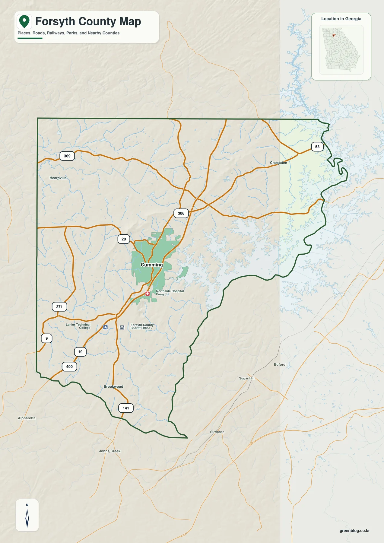
The general county map makes the road structure easy to recognize. Georgia 400 runs north-south through the central part of the county and passes Cumming, while Route 20 crosses the city from west to east. Route 306 intersects the main corridor farther north, and 369 spans the northern part of Forsyth County. The map also labels 53 near the northeastern shoreline, 371 toward the southwest, and 9, 19, and 141 through the southern half. These numbers are useful for county-scale orientation rather than turn-by-turn navigation: they show which parts of the county share the same broad corridor and where the road network reaches the boundary.
Cumming is surrounded by several useful map labels. Northside Hospital Forsyth is marked just south of the main developed area. Lanier Technical College and the Forsyth County Sheriff Office appear farther south, while Chestatee is labeled in the northeast, Heardville in the west, and Brookwood near the southern section. The map does not try to label every subdivision or service location. Instead, these points provide enough context to understand where the urban center sits and how the main roads move away from it.
The county outline itself changes character from west to east. Much of the western side is comparatively simple, but the eastern edge is broken into repeated coves and projections along the Lake Lanier shoreline. The county also narrows toward its southern end. This shape matters when reading the map because places that appear close in a straight line may be separated by water or by a boundary that bends around reservoir arms. The general map therefore works well as the first view before the water and elevation maps add more detail.
Why the City Map Focuses on Cumming
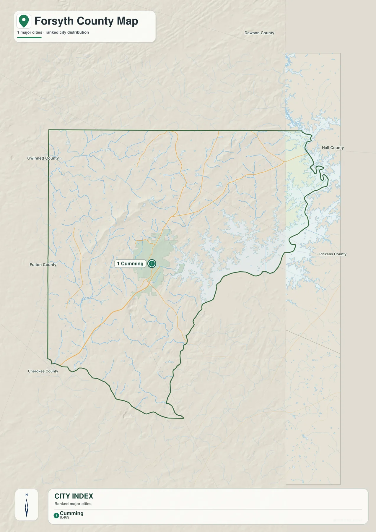
The city map is deliberately simple. Its CITY INDEX lists only Cumming, with a displayed value of 8,469. That number is reproduced from the supplied map and is best understood as the figure used by this map’s ranking system rather than as a newly verified population estimate for this article. Current demographic figures can be checked through the Census QuickFacts source below. The more important point is geographic: Cumming is the one city label emphasized inside the boundary, so the reader can see its position without competing road and landmark labels.
The existing source article describes Cumming as the county seat and the only incorporated city, with extensive suburban development spreading around it. The two map types complement that statement in different ways. The city map shows the official city reference in a stripped-down format, while the general map adds places such as Chestatee, Heardville, and Brookwood along with highways, institutions, and the reservoir edge. A reader should therefore not interpret the one-city display as meaning that the rest of Forsyth County is empty or undeveloped.
Cumming also sits well away from the most intricate eastern shoreline. A broad area remains north of the city, and the county narrows farther south. That placement makes the city useful as an anchor for comparing the different map themes. From Cumming, the road map can be followed toward Routes 306 and 369 in the north, the water map toward Lake Lanier in the east, and the elevation view toward the higher ridges that rise across the northeastern and central parts of the county.
Chestatee River, Reservoir Bays, and Interior Creeks
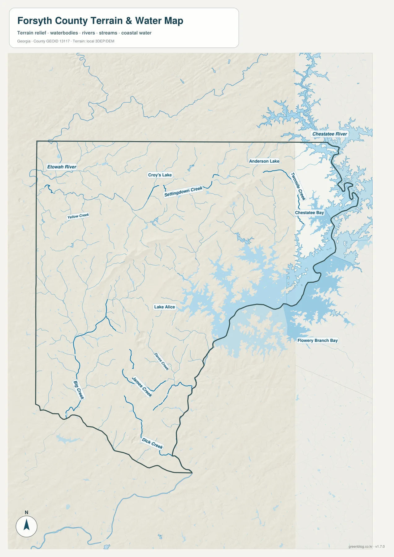
The eastern side dominates the water map because the reservoir shoreline repeatedly cuts into the county boundary. The Chestatee River is labeled near the northeastern edge, with Chestatee Bay immediately below it. Two Mile Creek approaches the same general water area from inside the county, while Flowery Branch Bay is labeled beyond the boundary farther southeast. The shape of the shoreline explains why the county’s eastern edge looks so irregular on the general map.
Inside the county, smaller waters provide a second layer of orientation. Yellow Creek appears in the northwest, Settindown Creek crosses the north-central area, and Croy’s Lake is marked nearby. Anderson Lake is shown in the northeast, while Lake Alice lies farther south and closer to the county’s middle. Dave’s Creek and James Creek run through the southern interior, Big Creek is labeled toward the southwest, and Dick Creek appears close to the southern tip. Those names make it possible to locate specific drainage areas without treating the entire eastern side as one undifferentiated lake shoreline.
The water map is especially helpful for comparing Cumming with the county’s natural features. Many small tributaries lie east and southeast of the city and continue toward the reservoir. Other creeks run south and west through broader inland valleys. This mix of shoreline, bays, creeks, and small lakes is more informative than a simple statement that Forsyth County borders Lake Lanier because it shows how water reaches deeply into the eastern part of the county while separate drainage lines cross the interior.
This is a county-scale location map, not a flood-risk, parcel, boating, or legal-shoreline product. A blue line or water polygon does not determine insurance requirements, navigation conditions, water depth, or a property boundary. Specialized current sources are required for those decisions. Here, the map is most useful for locating the Chestatee River and Chestatee Bay, identifying named creeks, and seeing how the water network relates to the terrain shown in the next view.
Elevation from About 233 to 594 Meters
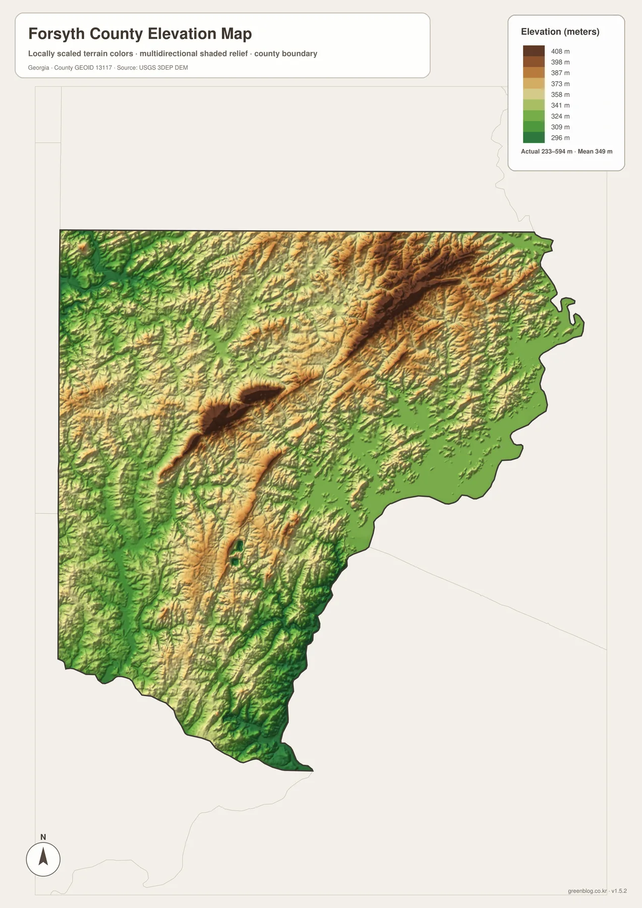
The supplied elevation map reports an actual range of approximately 233 to 594 meters and a mean of 349 meters. Its strongest high-relief feature is a long dark ridge in the northeastern part of the county. Another pronounced high area appears closer to the center-west, with several smaller ridges extending through the surrounding terrain. In contrast, the reservoir edge and many stream valleys are green and lower. The difference between the highest and lowest mapped areas is large enough that Forsyth County looks much more rugged on the elevation view than on the simplified city map.
The northeastern ridge is particularly useful for understanding the county’s terrain. It runs roughly parallel to parts of the eastern water system but remains inland from the lowest shoreline. Lower green ground surrounds many of the reservoir arms and creek corridors. When the water map is viewed first, that relationship becomes easy to follow: the Chestatee and reservoir shoreline occupy lower terrain, while ridges rise farther inside the county.
The southern and western parts are also varied. Narrow ridges alternate with lower valleys, and the corridors associated with Big Creek, James Creek, and Dick Creek align with greener low areas in several places. This is important context for a county often described through suburban growth and Georgia 400. Roads and developed areas occupy a landscape of repeated hills and drainage valleys rather than a flat plain, and the elevation map makes that underlying form visible without requiring specialized GIS software.
The color bands and shaded relief are intended for comparing terrain across the county, not for surveying a building site or designing grading, drainage, or construction. Exact site elevations require more detailed data and, when necessary, field measurement. For classroom geography, local orientation, or a presentation about Forsyth County, however, the map clearly distinguishes higher ridges from lower water corridors and provides a useful 233–594 meter county-wide range.
Connecting Suburban Roads with Water and Relief
Forsyth County becomes easier to understand when the map views are read as a sequence rather than as isolated images. The general map establishes Cumming and Georgia 400, then shows how Routes 20, 306, 369, 9, 19, and 141 spread across the county. The city view simplifies that information to one major incorporated-city reference. The water map shifts the focus eastward toward Lake Lanier, the Chestatee River, and interior creeks, while the elevation map explains why those waterways occupy lower valleys between higher ridges.
This comparison also puts the county’s suburban development in a more specific geographic setting. The existing source article notes broad suburban growth around Cumming and identifies Georgia 400 and Lake Lanier as important modern features. The maps show the physical setting behind that description: the main highway cuts through the interior, the reservoir fragments the eastern boundary, and hills and stream valleys continue between developed areas. The result is not one uniform suburban surface but a county where transportation, water, and relief repeatedly intersect.
For a classroom slide or a county-location reference, the general map is usually the best first choice. The city map is cleaner when the only question is where Cumming sits. A project about the Lake Lanier shoreline or named creeks benefits from the water view, while a terrain discussion is much clearer with the elevation map. The downloadable A3 JPG files preserve each of those focused views at a larger size than the webpage previews, making them suitable for printing or placing in a report or presentation.
Frequently Asked Questions
Why does the city map emphasize only Cumming?
The supplied city map lists Cumming as the single ranked major city. The existing source article also identifies Cumming as the county seat and only incorporated city. The general map adds other local place labels, roads, institutions, and the reservoir shoreline for broader context.
Which named waterways can I find on the map?
The water view labels the Chestatee River, Chestatee Bay, Settindown Creek, Yellow Creek, Two Mile Creek, Big Creek, James Creek, and Dick Creek, along with Croy’s Lake, Anderson Lake, and Lake Alice.
What elevation range is shown for Forsyth County?
The elevation map states an actual range of about 233 to 594 meters and a mean of 349 meters. Higher ridges are strongest in the northeast and parts of the interior, while the reservoir shoreline and many creek valleys appear lower.
What is included in the downloadable ZIP?
The archive contains four high-resolution A3 JPG files: a general Forsyth County map, a city map, a water map, and an elevation map. Each file keeps a different type of information visually clear while using the same county boundary.
Map File Information
Forsyth County A3 Map Files
- Included Files: 4 high-resolution A3 JPG map files shown in this article
- File Type: JPG files in a ZIP archive
- Intended Use: Printing, education, presentations, and map-based projects
Related Maps
Sources and Reference Material
- U.S. Census Bureau QuickFacts: Forsyth County – current official statistics
- New Georgia Encyclopedia: Forsyth County – county history and regional background
- U.S. Census Bureau TIGER/Line Shapefiles – county boundary and geographic reference data
- USGS National Hydrography – river, stream, and water-feature data
- USGS 3D Elevation Program – elevation data
Green Map creates custom-edited map images using open geographic data sources such as geoBoundaries, Natural Earth, OpenStreetMap, and government open data. These maps are edited visual materials, not raw data files, and are provided for education, documents, presentations, and graphic reference.