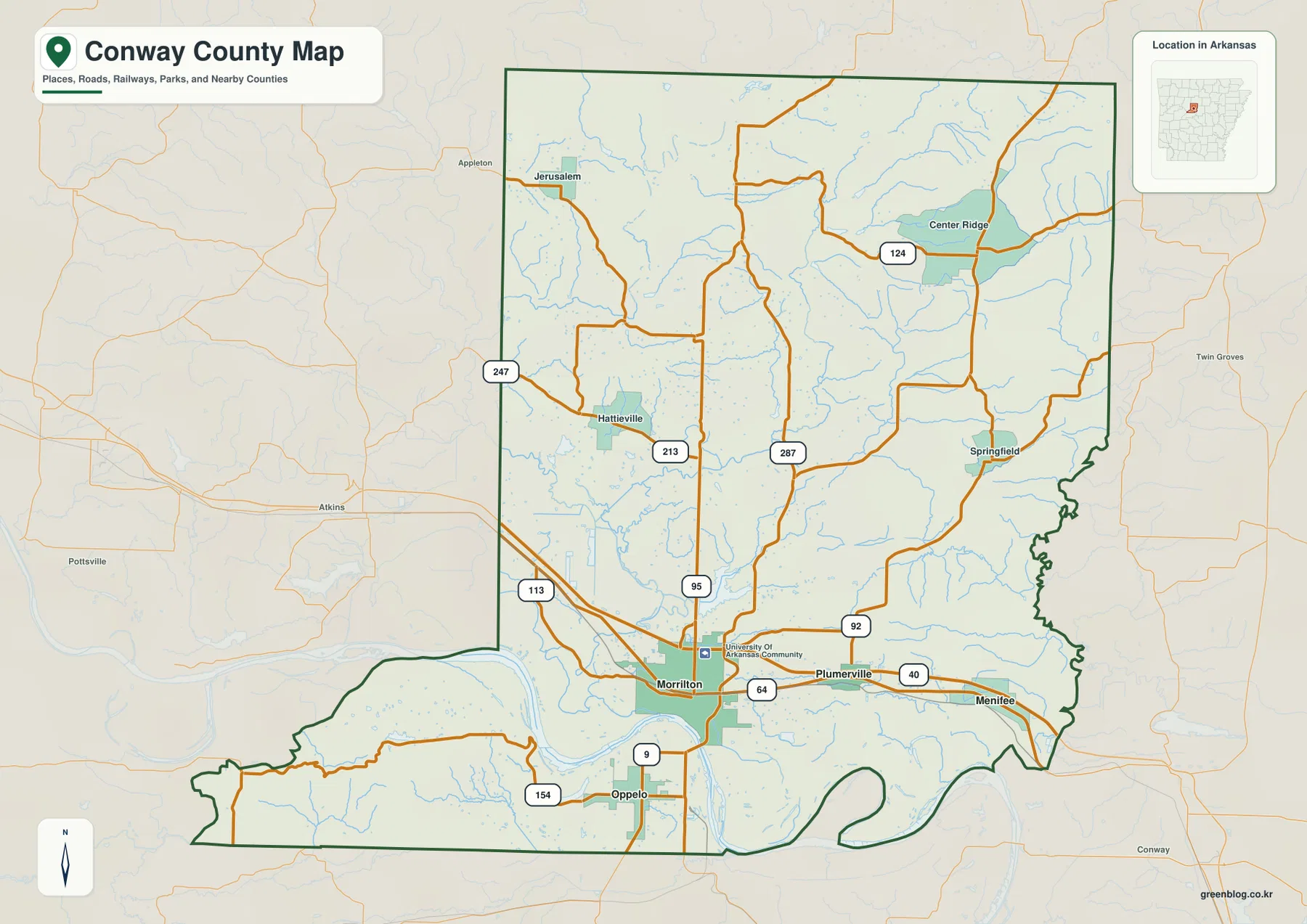
This Conway County Map page includes four high-resolution JPG originals in a downloadable ZIP, plus web previews for roads, towns, waterways, and elevation. Morrilton is the best place to begin because it sits just north of the Arkansas River and near the county’s main east-west transportation corridor. Plumerville and Menifee continue east from Morrilton, while Oppelo lies south of the river. Farther north, smaller places such as Hattieville, Jerusalem, Center Ridge, and Springfield are spread across a much larger area of ridges and creek valleys. The map set makes those contrasts easier to understand than a simple list of town names.
The Arkansas River is the feature that gives Conway County its broad shape. Trusted county references describe the river as dividing the county into two unequal parts, with most of the land lying to the north. The general map shows the same pattern: Morrilton, Plumerville, Menifee, and most of the mapped road network are north of the river, while the southern section is narrower and more fragmented. In the southwest, the land rises sharply into the Petit Jean Mountain area, creating a dramatic contrast with the low river corridor.
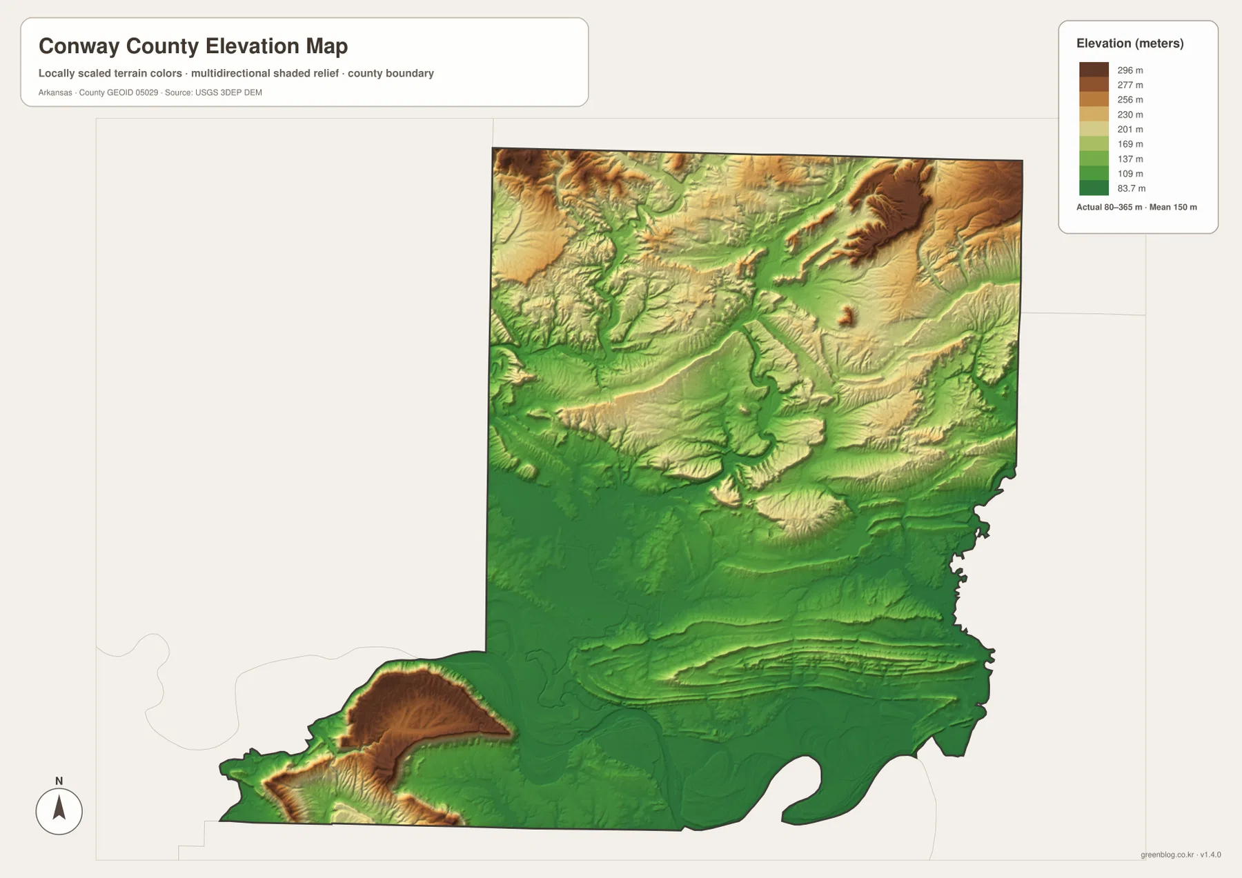
The supplied elevation map reports an actual range of about 80 to 365 meters and a mean near 150 meters. Low green terrain follows the Arkansas River across the southern center, while the northern half contains a mix of rolling uplands, long ridges, and narrow valleys. The northeast has one of the clearest high ridges on the map. To the southwest, Petit Jean Mountain rises again south of the river. Streams such as the East and West forks of Point Remove Creek, Ripley Creek, and Cypress Creek occupy the lower channels between those higher areas.
Table of Contents
Morrilton anchors the I-40 and US 64 corridor along the river-side lowlands
On the general county map, Morrilton is the most prominent town and the clearest road reference. Interstate 40 passes the northern side of the city and continues east across the county. US 64 follows a similar east-west direction through Morrilton toward Plumerville and Menifee. Routes 9, 95, 113, and 154 are also labeled close to Morrilton, showing how the city connects the river-side corridor with areas farther north and south. The University of Arkansas Community College at Morrilton appears as an additional landmark near the city.
Plumerville sits east of Morrilton between the main highway lines, while Menifee is farther east near the county boundary. Route 92 turns north from the Plumerville area into the eastern interior. The three towns form a recognizable east-west sequence on the low side of the county, close to the Arkansas River. This makes them useful for learning the county before moving into the more complicated road network of the northern hills.
Northwest of Morrilton, Routes 113 and 247 help define the western side, while Route 213 reaches toward Hattieville. Jerusalem lies still farther northwest. In the northeast, Center Ridge appears near Route 124 and Springfield lies south of it. Route 287 runs through the interior between the Morrilton corridor and the northern communities. These places are spread widely enough that the county feels very different once the map moves away from the I-40 corridor.
The county boundary also changes character near water. Its eastern edge becomes irregular through the middle and south, and the western side bends strongly near the Arkansas River. The map is designed for county-wide orientation rather than live travel conditions, so current road closures, construction, and turn-by-turn routing should still be checked with a navigation service. Its strength is showing how the major roads and settlements fit inside the county outline.
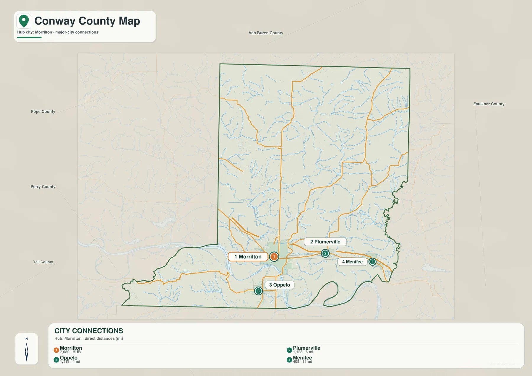
The four-city connection map separates the river corridor from Oppelo south of the Arkansas River
The city-connections map strips the county down to Morrilton, Plumerville, Oppelo, and Menifee. Morrilton is shown as the hub, Plumerville lies to the east, Menifee is farther east, and Oppelo sits south of Morrilton. Removing most minor roads and settlement labels makes the basic arrangement much easier to see. It is particularly useful as a first step before returning to the more detailed general map.
Plumerville and Menifee belong to the same broad eastern corridor, but they are not interchangeable reference points. Plumerville is the closer town to Morrilton and sits between the hub and the eastern edge. Menifee is much nearer the Faulkner County side. Oppelo is different because the Arkansas River separates it from the other three highlighted towns, giving the southern part of the city map a distinct visual break.
Neighboring county labels add regional context. Pope and Perry counties appear to the west, Yell County to the southwest, Van Buren County to the north, and Faulkner County to the east. The absence of a large northern city on the connector map is also meaningful: the northern half is represented on the detailed map by smaller places such as Hattieville, Jerusalem, Center Ridge, and Springfield rather than by another town comparable to Morrilton.
This city layer is a relative-location tool, not a road-mileage or travel-time map. Its main value is showing the southern settlement pattern without the distraction of dozens of secondary routes. Once Morrilton, Plumerville, Menifee, and Oppelo are placed correctly, the road and water maps become easier to interpret.
Point Remove Creek gathers northern drainage before the Arkansas River dominates the south
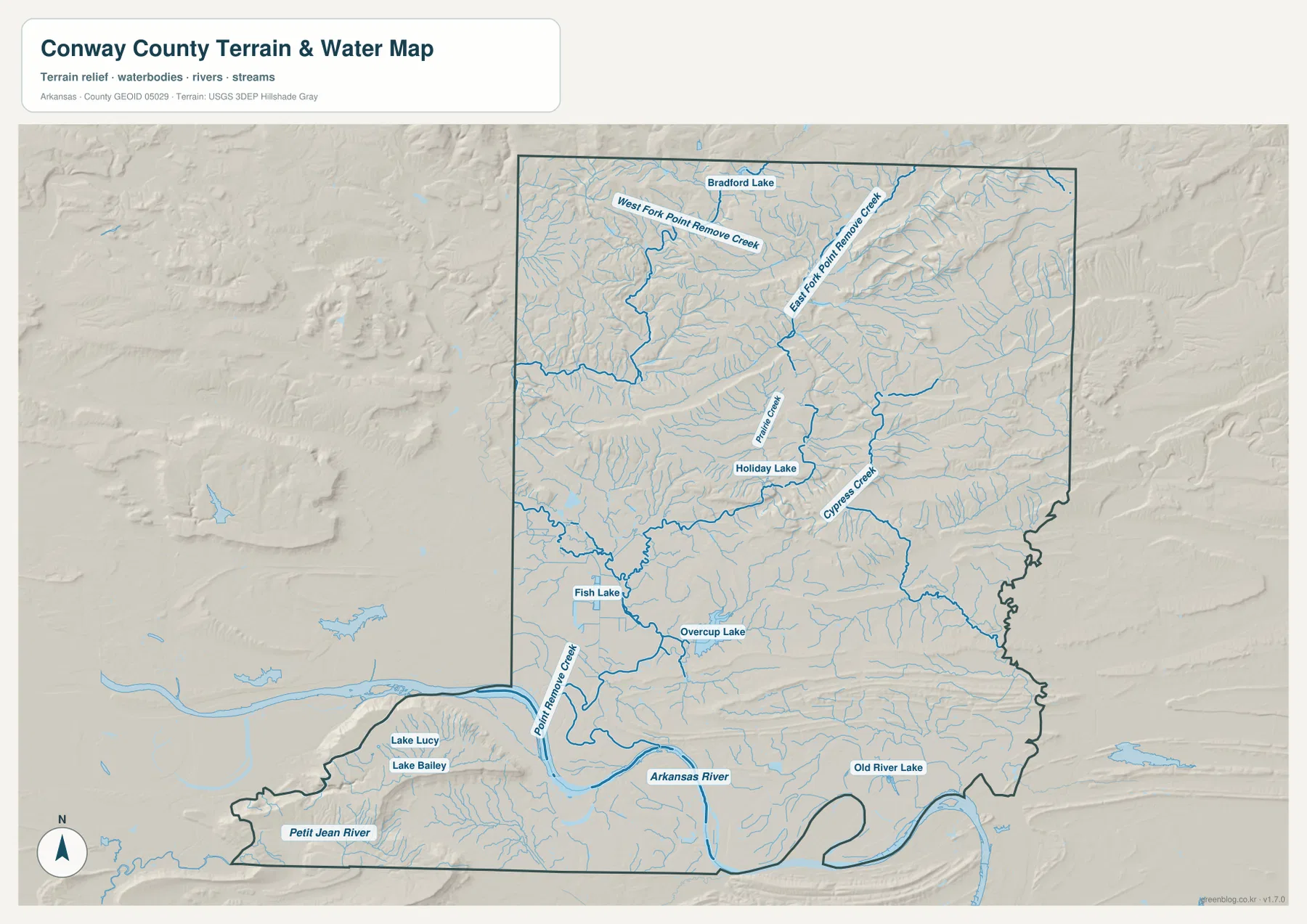
The hydrography map reveals a dense stream network that is much less obvious on the road map. In the north, West Fork Point Remove Creek and East Fork Point Remove Creek occupy separate valleys. Bradford Lake is labeled near the upper part of the county. Numerous smaller tributaries enter the two forks from short side valleys, matching the broken ridge-and-valley terrain visible in the elevation layer.
Farther south, Ripley Creek and Cypress Creek become useful central references, with Holiday Lake between them. Fish Lake and Overcup Lake appear closer to the lower western part of the main county body. Point Remove Creek itself approaches the Arkansas River from the north. The broad water surface of Overcup Lake is also recognizable on the general map, so it provides a good point for matching the road and water layers.
The Arkansas River controls the southern part of the hydrography map. Lake Lucy and Lake Bailey are labeled on the south side of the river toward the west, while Old River Lake appears farther east. The Petit Jean River crosses the narrow southwestern section. These larger water features help explain why the county’s southern boundary and internal shape are so different from the more continuous northern block.
A simple way to read the water map is to start with the Arkansas River, then move north through Point Remove Creek and its forks. Ripley Creek, Cypress Creek, Overcup Lake, and the smaller lakes can be added after that. The map is not a current flood, depth, boating-access, or property-boundary product. Water safety and engineering decisions require current agency data rather than this county-scale reference image.
The terrain steps down from northern ridges to the river, then rises sharply at Petit Jean Mountain
The elevation layer shows a county-wide low near 80 meters, a high near 365 meters, and an average around 150 meters. The broadest low area follows the Arkansas River through the southern center. Morrilton and Plumerville sit close to this low corridor. Moving north from the river, the terrain becomes more uneven and rises through a sequence of rolling ridges and valleys.
The northeastern quarter contains one of the strongest high ridges on the map. Long tan and brown slopes are cut by narrow green valleys, and the East Fork Point Remove Creek system follows those lower channels. The northwest is also broken by ridges, although the shape and height pattern are less continuous. This matches trusted descriptions of northern Conway County reaching into the Ozark foothills.
South of the Arkansas River, the southwestern projection creates a completely different high point. Dark brown relief rises abruptly from the surrounding green lowland and corresponds with Petit Jean Mountain. County and Encyclopedia of Arkansas references identify Petit Jean Mountain as the county’s major southern summit. Its position on the elevation image is easy to recognize because it is separated from the northern uplands by the wide low Arkansas River Valley.
The southeast returns to lower terrain, with long low ridges and broad green areas near the river. For that reason, Conway County cannot be summarized as simply “higher north, lower south.” A better description is three-part: rolling and locally high northern country, a low Arkansas River corridor across the middle-south, and the isolated high mass of Petit Jean Mountain to the southwest.
Three landmarks turn a complicated county outline into an easy mental map
Morrilton, the Arkansas River, and Petit Jean Mountain provide a practical framework for remembering Conway County. Morrilton marks the central road and government area north of the river. The Arkansas River creates the major internal divide. Petit Jean Mountain gives the smaller southern section a distinctive high landmark. Once those three anchors are clear, the Point Remove Creek system and northern communities can be added without making the map feel crowded.
East of Morrilton, Plumerville and Menifee follow the low transportation corridor. North toward Hattieville and Center Ridge, roads become more irregular as the terrain breaks into ridges and creek valleys. Comparing the general, water, and elevation maps explains why these parts of the county look different even though they belong to the same administrative area.
Oppelo is a useful reminder that the river matters to settlement placement. On the city map it appears directly south of Morrilton, but on the detailed map the Arkansas River creates a strong physical separation. Continuing west on the south side eventually brings the Petit Jean River and the high Petit Jean Mountain area into view. That sequence makes the southern section much easier to understand than treating it as an extension of the northern road grid.
Use the road map for orientation and switch layers when water or relief is the real question
The general county map is the best starting point for Morrilton, I-40, US 64, local communities, and the county boundary. The city-connections map is cleaner when you only need the relative positions of Morrilton, Plumerville, Oppelo, and Menifee. The water map is the right choice for the Arkansas River, Petit Jean River, Point Remove Creek, Overcup Lake, and smaller creeks, while the elevation map makes the northern ridges, river lowlands, and Petit Jean Mountain contrast much easier to see.
Using two layers together can be more useful than forcing every detail into one map. Pair the general map with the water layer to understand how Morrilton and the east-west road corridor sit near the Arkansas River. Pair water with elevation in the north to see how Point Remove Creek and its forks occupy low valleys between ridges. These comparisons are especially helpful in lessons or reports where one map can establish location and the next can explain the landform behind it.
For printing or close inspection, use the full-resolution JPG files rather than enlarging the WebP previews. The ZIP below contains the county map, city map, water map, and elevation map at 3638 × 2572 pixels each. Small road numbers, creek names, lake labels, and relief colors are easier to inspect in the original files, making them suitable for lessons, presentations, reports, and personal reference.
Frequently Asked Questions
Why does the Arkansas River make Conway County look divided?
The river crosses the southern part of the county and separates the much larger northern block from a smaller southern section. Morrilton, Plumerville, and Menifee are north of the river corridor, while Oppelo and the Petit Jean Mountain area lie to the south, so the split is easy to see on several map layers.
Which map is best for Point Remove Creek and the named lakes?
Use the water map. It labels the East and West forks of Point Remove Creek, Ripley Creek, Cypress Creek, Bradford Lake, Holiday Lake, Fish Lake, Overcup Lake, Old River Lake, and other water features that are less prominent on the road map.
Where is Petit Jean Mountain on the elevation map?
It appears in the southwestern section south of the Arkansas River as the strongest isolated area of dark brown high terrain. The supplied elevation map spans about 80 to 365 meters, and the Petit Jean Mountain area stands out sharply from the surrounding river lowlands. The map is for broad comparison, not survey-grade elevation work.
Map File Information
The ZIP contains high-resolution JPG originals for the Conway County general map, city map, water map, and elevation map.
- Included Files: County map, city map, water map, elevation map
- Printable Size: 3638 × 2572 px each
- File Type: JPG
Related Maps
Sources and references
- Official Conway County, Arkansas website: county government and local information, including Morrilton and Petit Jean State Park context.
- Association of Arkansas Counties – Conway County: county seat, Arkansas River, Petit Jean Mountain, and landscape background.
- Encyclopedia of Arkansas – Conway County: background on the Arkansas River division, Ozark foothills, and Petit Jean Mountain.
- U.S. Census Bureau TIGER/Line Shapefiles: official reference for county boundaries, roads, and place geography.
- USGS National Hydrography: official reference for rivers, streams, and waterbodies.
- USGS 3D Elevation Program: official elevation and terrain reference.
Green Map creates custom-edited map images using open geographic data sources such as geoBoundaries, Natural Earth, OpenStreetMap, and government open data.
These maps are edited visual materials, not raw data files, and are provided for education, documents, presentations, and graphic reference.