Terrell County sits in southwestern Georgia, with Dawson serving as the county seat and the clearest reference point for its roads and communities. This page pairs that local orientation with downloadable map files: you can download one ZIP containing four original A3 high-resolution JPG maps for printing, presentations, or offline reference. The maps show how Bronwood, Sasser, and Parrott sit around Dawson, where creeks and ponds spread across the county, and how elevation falls from the higher northwest toward lower ground in the east and south.
Dawson stands out because several numbered routes meet or split near the city. Parrott lies to the northwest, Bronwood is east to northeast of Dawson, and Sasser is southeast. The county boundary is also distinctive: long straight stretches appear on parts of the west and south sides, while the northern and eastern edges bend through a series of angles and irregular sections. When the water and elevation maps are compared with the settlement map, the county looks less like a flat blank background and more like a landscape of gentle uplands cut by creek valleys.
Table of Contents
Roads converging on Dawson and the shape of Terrell County
The county reference map makes Dawson the easiest place to start. Road labels 82 and 50 approach Dawson from the west, while 49 comes down from the north. Route 118 angles northeast toward Bronwood, 32 continues east from the Dawson area, and 520 runs southeast in the direction of Sasser. Routes 45 and 55 extend southward. The map is not intended to replace a turn-by-turn road map, but this pattern is enough to show why Dawson functions as the main road junction within the county.
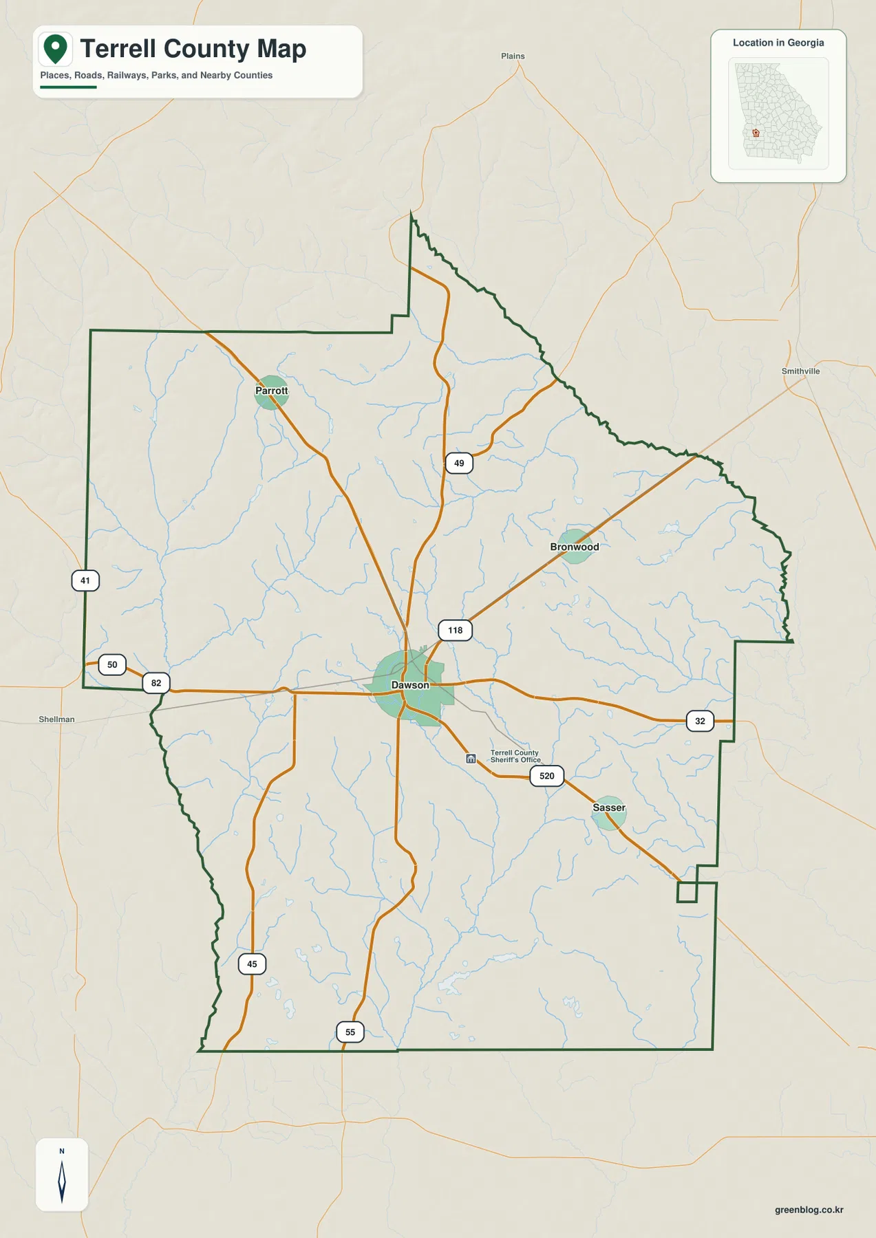
The community positions reinforce the road pattern. Parrott is northwest of Dawson, Bronwood lies to the northeast or east-northeast, and Sasser is southeast. Outside the county, labels such as Plains to the north, Smithville to the east, and Shellman to the west help place Terrell County within a wider southwest Georgia setting. Those outside labels are useful orientation points, but the dark county outline remains the key boundary to follow when distinguishing places inside Terrell County from nearby communities beyond it.
The outline itself is worth noticing. A narrow extension reaches northward before the boundary turns southeast through an irregular northeastern edge. The east side contains several bends, and the southeastern corner includes small inset and protruding sections. By comparison, portions of the western and southern edges are straighter. This makes the county recognizable even when the map is being used primarily as an outline reference rather than for city or road information.
How Bronwood, Sasser, and Parrott are arranged around Dawson
The city-connections map simplifies the county to a hub-and-spoke view centered on Dawson. Its connection panel lists Bronwood at about 6 miles from Dawson, Sasser at about 7 miles, and Parrott at about 9 miles. These are straight-line distances, not driving distances. Roads curve, intersect, and may take a longer route than a direct line, so the numbers should be used to compare relative separation rather than to estimate mileage for a trip.
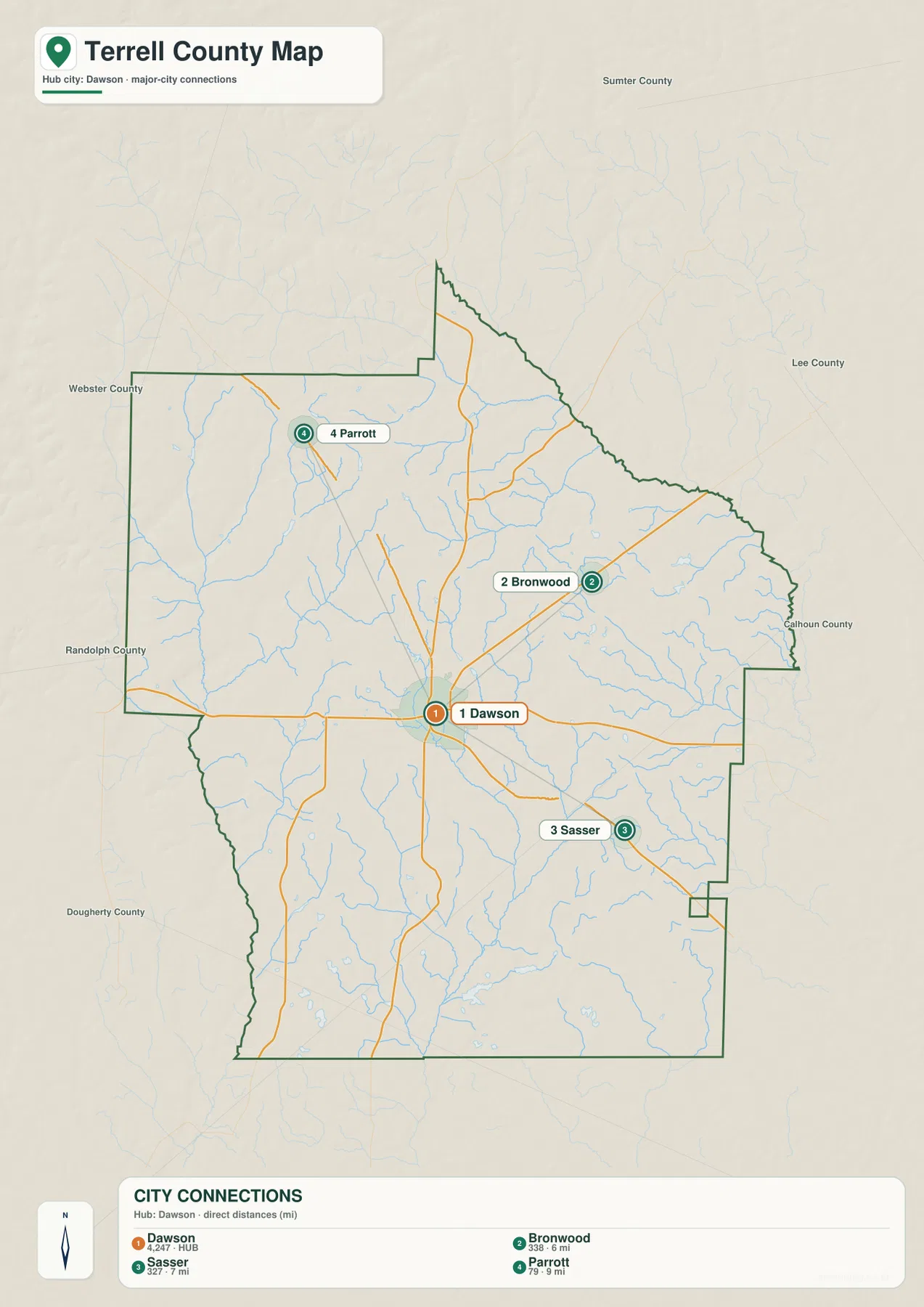
The surrounding county labels add another layer of orientation. Sumter County is shown to the north, Lee County to the northeast, Calhoun County to the east, and Dougherty County to the southwest. Randolph County and Webster County appear along the western side. This makes it easier to understand why Bronwood sits on the eastern side of the Terrell County community pattern, why Parrott is associated with the northwest, and why Sasser occupies the southeast. The map does not claim that these four places represent every community in the county; they are the selected places used for this county-level reference.
Dawson is also the county seat. The existing county material notes that Terrell County was established in 1856 and describes agriculture, including peanut and cotton production, as part of the county’s background, along with access toward the Albany area. That context fits the map’s small-city pattern, but the city-connections graphic is not a population-density or land-use map. The size of a label or the amount of open space around a town should not be interpreted as a measurement of population, farmland, or developed land.
Creeks and ponds spread across the county
The terrain-and-water map replaces most road emphasis with a network of blue channels. Wolf Creek is one of the clearer named streams in the western-central part of the county. Brantley Creek and Chickasawhatchee Creek extend through the central and southeastern areas, with many smaller tributaries joining them. The density of these lines is important: Terrell County is not shown as a place with one dominant river cutting through an otherwise empty landscape. Instead, numerous smaller drainage lines divide the county into a series of shallow valleys and interstream areas.
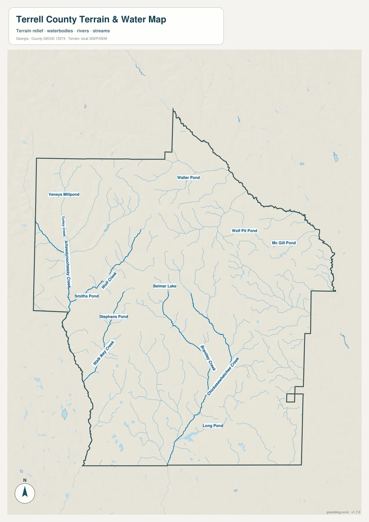
Several small water bodies provide convenient local reference points. Belmar Lake is labeled near the central part of the map. Waller Pond appears farther north, while Wolf Pit Pond and Mc Gill Pond are labeled toward the northeast and east. Smiths Pond is on the western side, and Long Pond appears in the south. The map also contains other ponds and small channels. Their labels can help a reader locate a general part of the county, but the graphic does not provide water depth, public-access status, shoreline ownership, or fishing conditions.
This is also not a flood-hazard map or a navigation chart. A location next to a mapped creek should not automatically be classified as flood-prone, and an area with fewer visible blue lines should not automatically be treated as safe from flooding. The useful role of this map is to show where named waterways and ponds lie and how smaller tributaries connect across the county. It becomes especially informative when placed beside the elevation map, because many of the lower terrain lines follow the same general corridors as the mapped drainage network.
Higher northwest terrain and lower ground toward the southeast
The elevation map shows a clear county-scale contrast. The map reports an actual elevation range of about 66 to 152 meters and a mean elevation of 101 meters. Browns and oranges cover much of the northwest and western uplands, indicating the relatively higher part of Terrell County. Greens become more extensive across the east, south, and especially the southeast, where lower terrain dominates. The county is not mountainous, but the local relief is strong enough to show ridges, broad slopes, and stream-cut valleys rather than a uniformly level surface.
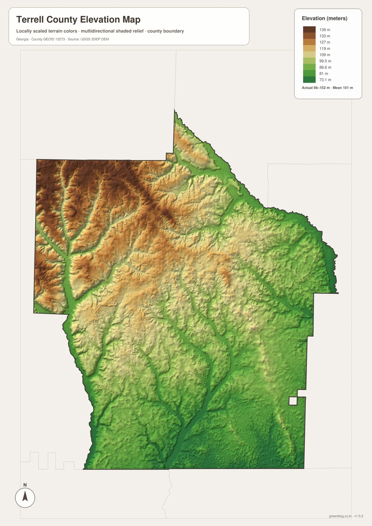
Looking beyond the color legend, the shape of the valleys is equally useful. Green corridors cut into the higher western and northwestern terrain, and several lower paths continue toward the center and south. When these forms are compared with the water map, many of them correspond to the general direction of creek channels. That relationship is expected because streams tend to occupy lower ground, but the maps are still generalized county references rather than engineering surfaces. They are appropriate for understanding broad terrain differences, not for determining the exact elevation of a parcel, road grade, building site, or drainage structure.
Dawson lies between the county’s higher northwest and lower southeast zones. Bronwood’s eastern position places it closer to the greener, lower side of the elevation surface, and Sasser in the southeast is also within a generally lower area. Parrott is northwest of Dawson and therefore closer to the higher terrain shown in brown and orange. The elevation map does not label these towns directly, so this comparison comes from matching their positions with the city map rather than from reading city names on the elevation graphic itself.
Choosing the map that fits the question
For a quick county overview, the boundary-and-road map is the best starting point because it combines Dawson, the three selected smaller communities, numbered roads, and the county outline. The city-connections map is more useful when the main question is how Bronwood, Sasser, and Parrott are positioned around Dawson and how their straight-line distances compare. The terrain-and-water map is the better choice for named creeks, ponds, and tributary patterns, while the elevation map makes the northwest-to-southeast height difference much easier to see.
A school report or county profile can often begin with the county map and add either the water or elevation map when natural features matter. A local-history or genealogy project may use the county outline and current place names as an orientation layer before consulting older records. None of the four maps should be treated as a substitute for parcel boundaries, legal surveys, flood-zone determinations, or turn-by-turn navigation. Their strength is that they provide a clean county-level reference while keeping four different kinds of geographic information separate.
Because the JPG files are separate, you can choose only the map needed for a particular document. Use the county map when labels and road orientation matter, the city map when Dawson-to-community relationships are the focus, the water map for creek and pond locations, and the elevation map for broad terrain differences. The water and elevation files are particularly helpful when explaining the county’s natural setting, but they retain the same limitations described above and should not be used as flood, navigation, surveying, or engineering products.
Frequently Asked Questions
Are the 6-, 7-, and 9-mile distances from Dawson driving distances?
No. The city-connections map uses straight-line distances. Bronwood is shown at about 6 miles from Dawson, Sasser at about 7 miles, and Parrott at about 9 miles. Actual driving routes can be longer because roads do not follow a perfectly direct line.
Can the water map be used to identify flood-risk areas?
No. It is a terrain-and-water reference that shows named creeks, ponds, and smaller drainage lines. It does not contain official flood-zone boundaries, flood depths, or property-level risk information. Use an appropriate official flood source when that decision matters.
Is the 66–152 meter elevation range suitable for surveying or construction?
No. The range is useful for understanding the broad contrast between higher northwestern terrain and lower eastern and southern ground, but the map is a generalized county-scale elevation surface. It should not replace site-specific survey or engineering measurements.
Map File Information
The ZIP below contains the four original A3 high-resolution JPG maps shown in this article. Use it when you need larger files for printing, editing, or keeping the county reference maps together rather than relying on the lighter WebP previews displayed on the page.
- File Type: ZIP containing four A3 high-resolution JPG files
Related Maps
Sources and references
The county-specific descriptions above are based primarily on the four supplied Terrell County maps and the existing county material. The following external resources provide additional county, boundary, hydrography, and elevation references.
- U.S. Census Bureau QuickFacts for Terrell County, Georgia
- New Georgia Encyclopedia: Terrell County
- U.S. Census Bureau TIGER/Line Shapefiles
- USGS National Hydrography
- USGS 3D Elevation Program
Green Map creates custom-edited map images using open geographic data sources such as geoBoundaries, Natural Earth, OpenStreetMap, and government open data. These maps are edited visual materials, not raw data files, and are provided for education, documents, presentations, and graphic reference.