The Bay County Florida Map is easiest to understand when St. Andrews Bay is treated as the county’s central geographic feature rather than as empty water between places. Panama City, the county seat, sits on the inner bay, while Panama City Beach occupies the Gulf-facing coast to the west. Lynn Haven extends north toward North Bay, and Callaway, Parker, and the eastern shoreline continue toward East Bay and Mexico Beach. The result is a county where cities, roads, bays, and bridges fit together around water rather than along one simple coastal strip.
This page provides three downloadable map views of the same county: a general county map with roads and place labels, a city map that makes the main municipalities easier to compare, and a water map focused on bays, bayous, creeks, and the Gulf shoreline. They are designed to be used together, but each one is also useful on its own. The download box later on the page contains the three maps as high-resolution A3 JPG files in one ZIP archive.
Table of Contents
A County Shaped by Bays Instead of a Straight Coastline
Bay County lies on the Gulf side of Florida’s Panhandle. Its southern edge opens to the Gulf of Mexico, but the shoreline turns inward repeatedly rather than following a straight east-west line. West Bay occupies a large part of the western interior, North Bay reaches north of the Panama City urban area, St. Andrews Bay forms the central harbor and estuary, and East Bay spreads across the eastern side. Those water bodies divide the land into peninsulas, narrow shorelines, and bridge-dependent corridors.
The surrounding counties help establish the larger setting. Walton County is to the west, Washington County is to the north, and Jackson, Calhoun, and Gulf counties border the northern and eastern sides. The county also has a narrow extension toward the northeast, which makes its outline less regular than a simple coastal rectangle. When that shape is viewed together with the bays, the locations of Panama City, Panama City Beach, Lynn Haven, and Mexico Beach make much more sense.
Panama City Sits at the Center of a Bay-Side Urban Cluster
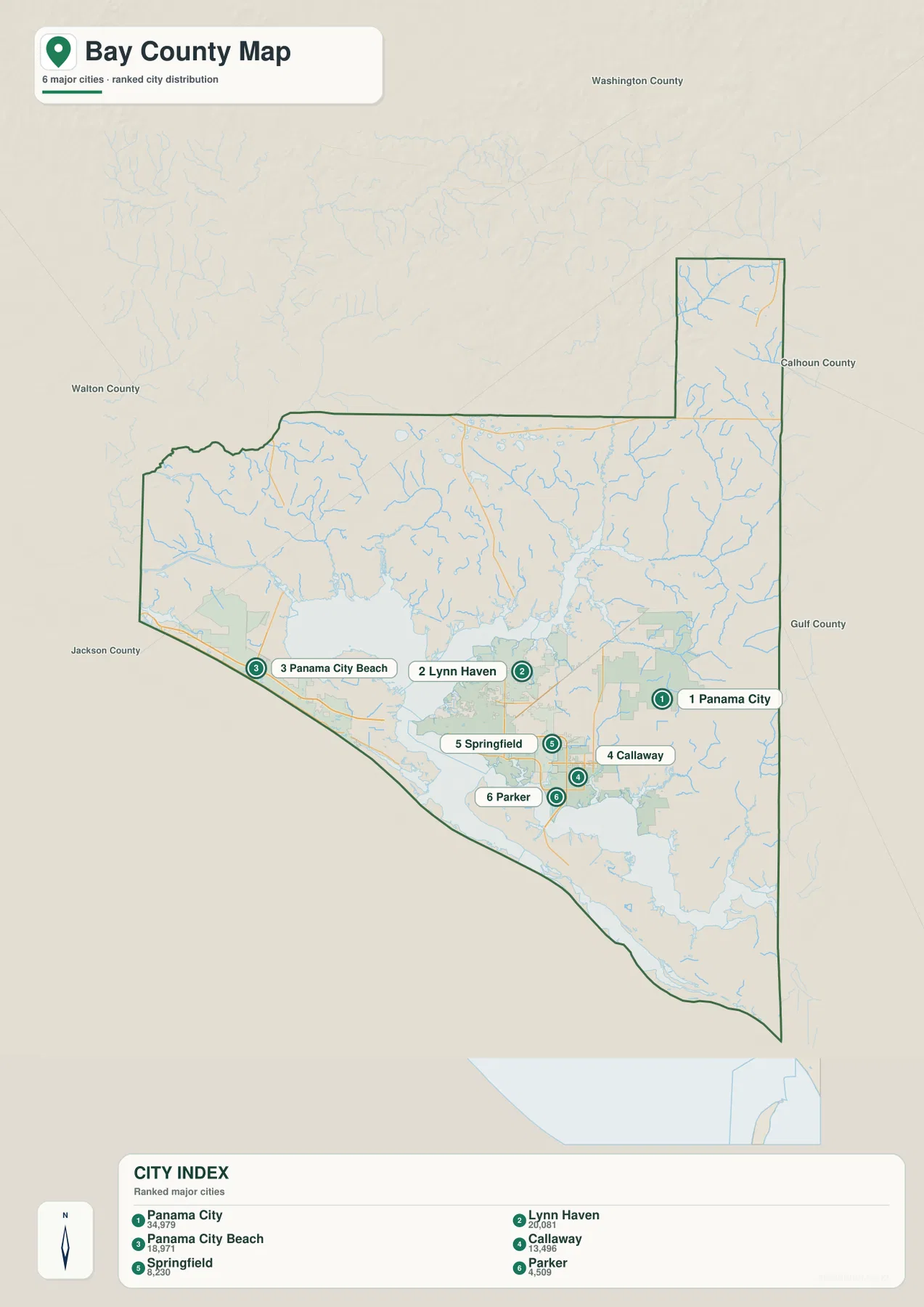
The city map shows that the county’s largest municipalities are concentrated near the southern bays rather than spread evenly across the full county. Panama City is listed first in the supplied city index, followed by Lynn Haven and Panama City Beach. Callaway, Springfield, and Parker form another group immediately east and southeast of the county seat. Even though these places are close together on the map, St. Andrews Bay, North Bay, bayous, and bridge crossings separate their road connections.
Panama City is the administrative center and an inner-bay city. Lynn Haven lies farther north toward North Bay, while Springfield and Parker sit just east of Panama City. Callaway continues the urban area toward East Bay and the Tyndall side of the county. Panama City Beach is different: it is west of St. Andrews Bay and runs along the Gulf-facing coast, so its shoreline orientation and travel patterns are not the same as those of Panama City despite the shared name.
This distinction matters for anyone using the map to plan a route or identify a location. Panama City Beach and Panama City are separate municipalities, and travel between them depends on the limited crossings around St. Andrews Bay. The same is true when extending a trip north to Lynn Haven or east to Callaway. The main urban area is therefore better pictured as a group of communities wrapped around the bay system than as one continuous city.
Roads Link the Gulf Coast to the Northern Interior
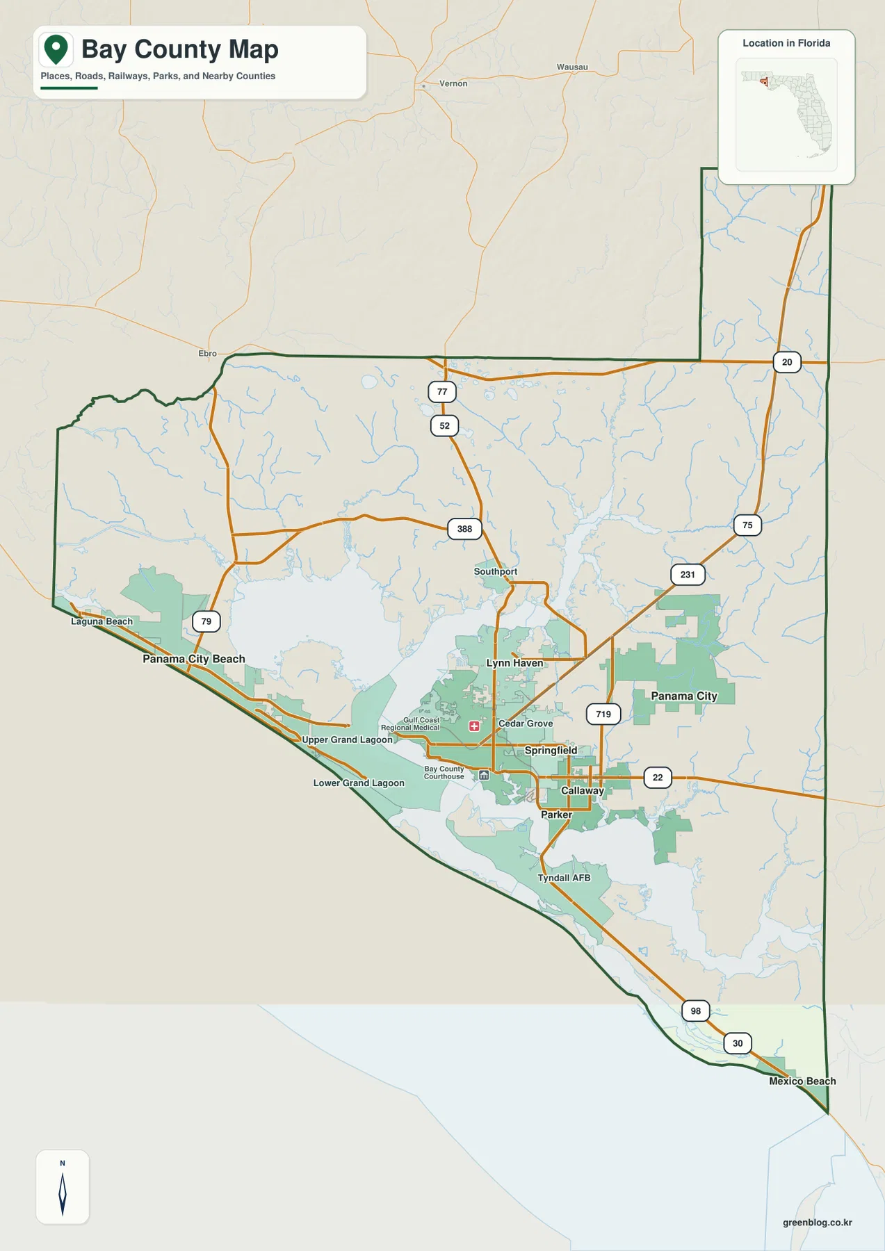
U.S. 98 is the most obvious east-west road on the county map. It connects the Panama City Beach area with Panama City and continues east toward the Tyndall and Mexico Beach side of the county. Because so much of the county’s population and visitor activity is near the coast and St. Andrews Bay, U.S. 98 provides a useful first line to trace when learning the region. It also demonstrates how the southern road network bends around bays and bridge approaches instead of following a simple grid.
The northbound roads serve a different purpose. U.S. 231 runs north from Panama City and continues through the county’s northeastern extension toward the interior Panhandle. SR 77 passes through the Lynn Haven area and heads north toward Washington County, while SR 79 rises from the western Panama City Beach side toward the inland part of the Panhandle. SR 388 appears in the western part of the county near the West Bay and airport area. Together these routes show how the coast is tied to inland communities and the broader highway system.
Water explains many of the apparent gaps in the road pattern. In the southern urban area, broad bays and smaller bayous limit where roads can cross. Farther north, a dense network of creeks and tributaries cuts through less urbanized land. A straight-line distance on the map can therefore be misleading. When the map is being used for orientation rather than turn-by-turn navigation, comparing the road lines with the water features gives a more realistic sense of how one part of Bay County connects to another.
West Bay, North Bay, St. Andrews Bay, and East Bay
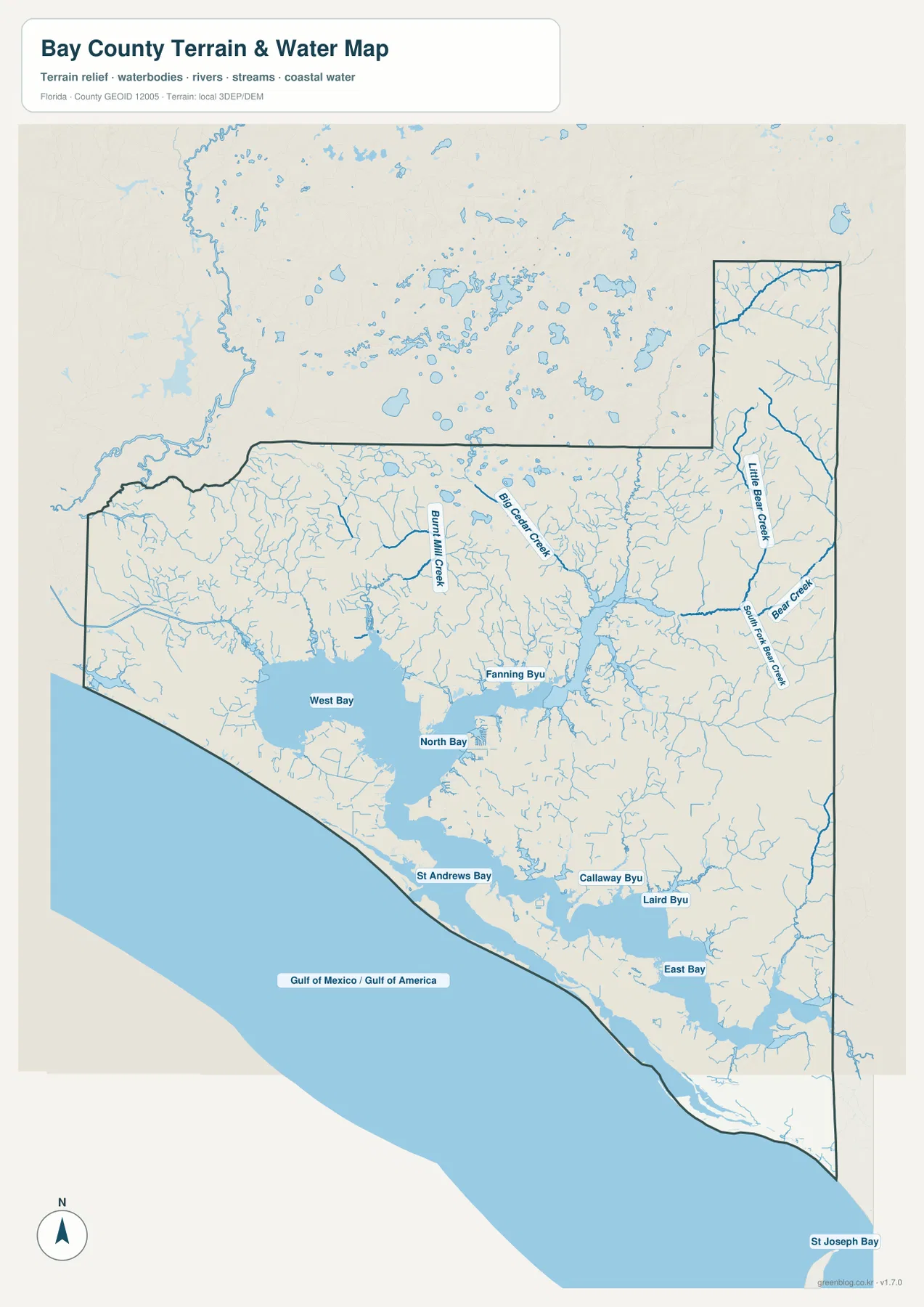
The dedicated water map makes Bay County’s geography much clearer than a road-only view. West Bay dominates the western interior. North Bay extends above the central urban area, St. Andrews Bay forms the main harbor and inner coastal basin, and East Bay occupies the eastern side. Smaller named waters include Fanning Bayou, Callaway Bayou, and Laird Bayou. Inland streams such as Burnt Mill Creek, Big Cedar Creek, Little Bear Creek, Bear Creek, and Southport Creek show that the county’s water network reaches far beyond the immediate shoreline.
St. Andrews Bay is especially important because it sits between the county’s best-known cities and the Gulf. Panama City faces the inner bay, while Panama City Beach lies on the Gulf side west of the bay entrance. The supplied source material also identifies the St. Andrews Aquatic Preserve and the coastal area around St. Andrews State Park and Shell Island. These features help explain why the bay entrance is not just a blank opening to the sea but a major environmental and geographic landmark.
The eastern shoreline has a different appearance. East Bay and several bayous break up the coast near Callaway and Parker, and the county then narrows into a longer Gulf-facing section toward Mexico Beach. The map continues east toward the Gulf County line, where Mexico Beach is geographically separate from Panama City Beach. Seeing both places on the same county map is useful because their similar names can suggest a closer relationship than their actual positions show.
Northern Bay County Looks Very Different from the Southern City Belt
Most of the labeled cities are near the southern part of the county, but much of Bay County extends north of that urban concentration. In the north, the map shows fewer built-up place labels and more creeks, local roads, and open interior land. U.S. 231 and SR 77 become more important for understanding direction because they connect the Panama City area with the Panhandle interior. This contrast is easy to miss when Bay County is thought of only as a beach destination.
The east also becomes less urban beyond the Panama City–Callaway area. East Bay, bayous, and the Tyndall side of the county create a narrower set of practical road corridors, with U.S. 98 carrying much of the visible east-west movement. Farther along the Gulf shore, Mexico Beach appears near the eastern county boundary. It belongs to the same county as Panama City Beach, but the two coastal communities are separated by the central bay system, Panama City, and a long stretch of eastern shoreline.
Which Bay County Map Is Best for Your Purpose?
Use the general county map when the main goal is orientation. It combines the county boundary, major communities, roads, surrounding counties, and the Gulf coast in one view. It is the most useful starting point for locating Panama City, Panama City Beach, Lynn Haven, Mexico Beach, U.S. 98, U.S. 231, SR 77, and SR 79 before moving to a more specialized map.
The city map is better when the question is where the major municipalities sit in relation to one another. Its ranked labels make Panama City, Lynn Haven, Panama City Beach, Callaway, Springfield, and Parker easy to compare without the road detail taking over the page. For a presentation or worksheet about settlement patterns, this simpler view can be more readable than the full county map.
Choose the water map when bays, bayous, creeks, or shoreline form are the main subject. It makes West Bay, North Bay, St. Andrews Bay, East Bay, and the named smaller waterways more prominent, which is useful for explaining why roads bend, why bridge crossings matter, and why the county’s communities occupy distinct shoreline sectors. Because all three files use the same county setting, they can also be printed side by side for comparison.
A Practical Way to Read the Maps Together
Start with St. Andrews Bay and locate Panama City on the inner side and Panama City Beach on the Gulf side. Then add Lynn Haven to the north and Callaway and Parker to the east. Once those places are fixed, trace U.S. 98 along the southern corridor and U.S. 231, SR 77, and SR 79 toward the north. Finally, switch to the water map and compare the same locations with West Bay, North Bay, East Bay, and the smaller bayous.
This sequence avoids a common problem with coastal maps: focusing on the beach line while overlooking the water that cuts into the county behind it. In Bay County, the inner bays are just as important as the Gulf shoreline for understanding settlement and movement. The general map explains the county as a whole, the city map clarifies the southern population cluster, and the water map explains why that cluster has the shape it does.
Frequently Asked Questions
Are Panama City and Panama City Beach the same place?
No. Panama City is the Bay County seat on the inner side of St. Andrews Bay. Panama City Beach is a separate municipality on the Gulf-facing coast west of the bay. They are part of the same broader county area, but the bay and bridge crossings make their locations and travel patterns distinct.
Which map is best for seeing the bays and creeks?
The water map is the best choice. It emphasizes West Bay, North Bay, St. Andrews Bay, East Bay, smaller bayous, and several inland creeks, so it is easier to see how water separates communities and shapes the county’s shoreline.
What is included in the downloadable ZIP?
The ZIP includes three high-resolution JPG files: a general county map, a major-city map, and a water map. Each file highlights a different part of the same geography, allowing you to choose the clearest view for roads, settlements, or coastal and inland water features.
Map File Information
The download ZIP contains the Bay County general map, city map, and water map as high-resolution A3 JPG files. Use the set for printing, geographic reference, lessons, presentations, or side-by-side comparison.
- Included Files: 3 high-resolution A3 JPG maps described on this page
- File Type: JPG files in a ZIP archive
- Intended Use: Printing, education, presentations, and map-based projects
Related Maps
Sources and References
- U.S. Census Bureau QuickFacts — Bay County, Florida — county population, area, and demographic reference
- Bay County official website — county government and local information
- Florida Department of Transportation — Bay County Freight & Transportation Profile — major highways, port, and airport context
- Florida Department of Environmental Protection — St. Andrews Aquatic Preserve — St. Andrews Bay coastal and estuarine context
- Florida DEP Coastal Access Guide — Bay County — St. Andrews State Park and coastal access reference
Green Map creates custom-edited map images using open geographic data sources such as geoBoundaries, Natural Earth, OpenStreetMap, and government open data. These maps are edited visual materials, not raw data files, and are provided for education, documents, presentations, and graphic reference.