Crittenden County sits in western Kentucky with Marion near the center, the Ohio River touching the northwestern edge, and a network of creeks and rolling hills spreading across the interior. The general map makes Marion the easiest place to orient yourself because U.S. 60, U.S. 641, KY 91, KY 297, KY 365, and several smaller numbered routes converge around or near the city. From that center, the county opens toward river lowlands in the northwest and more broken hill country through much of the interior. High-resolution map files are available for download in the section below.
This page explains the county boundary, road network, Marion’s position, the Ohio River and named local waterways, and the 98–254 meter elevation range shown in the supplied maps. High-resolution JPG originals of the same maps are available in a ZIP for printing or close label inspection. These are reference maps for geographic orientation; they are not substitutes for live navigation, legal parcel boundaries, flood determinations, or survey-grade measurements.
Table of Contents
Marion at the center of a road network that reaches the Ohio River edge
Marion is the most useful starting point on the general county map. U.S. 60 runs across the central part of the county, while U.S. 641 heads south from the Marion area. KY 297 reaches westward, KY 365 extends north, and KY 91 continues south. Tolu provides a smaller reference point toward the northwestern side, and Crayne appears just south of Marion, helping separate the central and southern parts of the county.
The road pattern becomes more irregular away from Marion. KY 135 and KY 723 appear on the western side closer to the Ohio River, while KY 855, KY 902, KY 70, and KY 295 serve the narrowing southern portion. These routes often bend rather than forming a simple grid, which matches the many creek valleys and low ridges visible in the terrain layers.
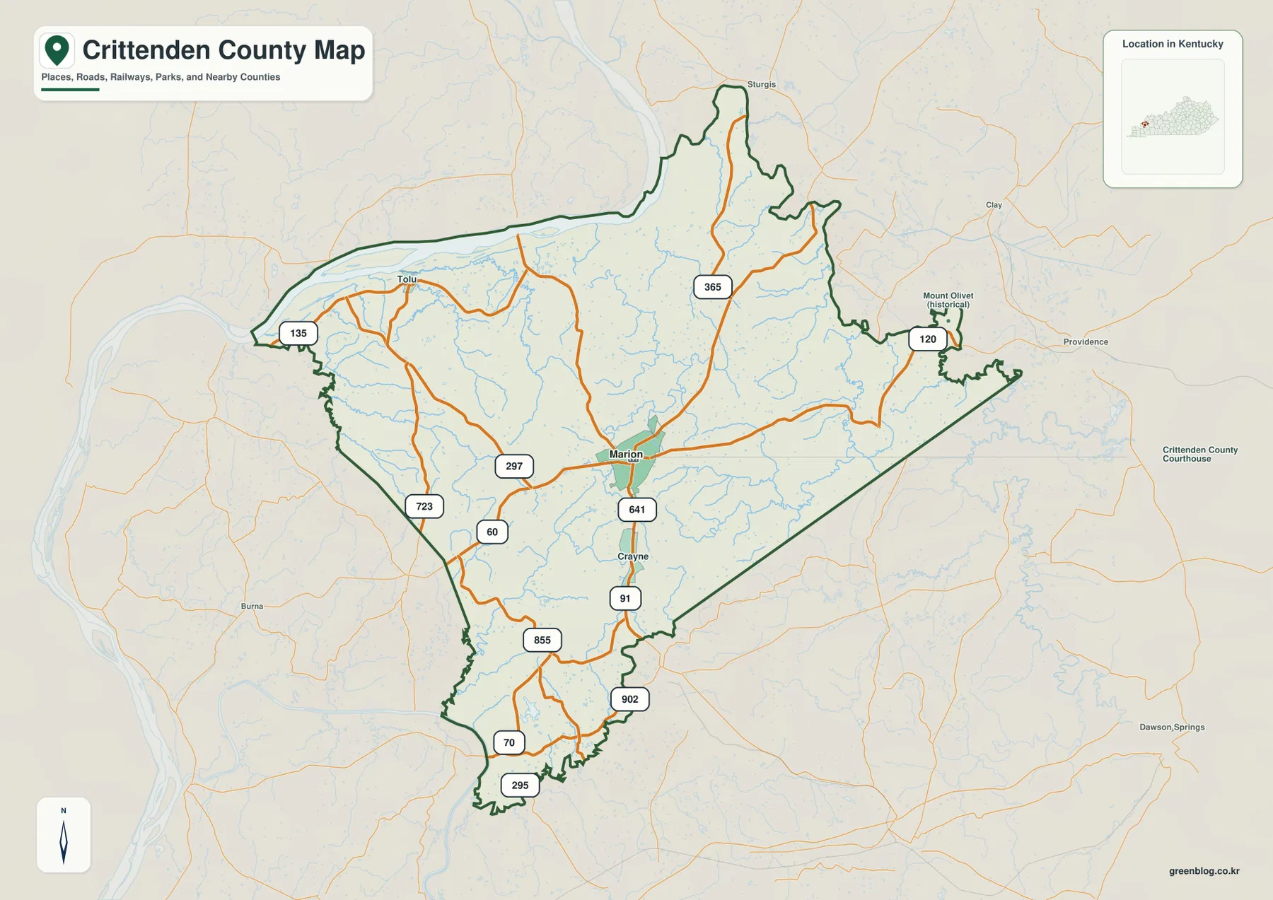
On the northeastern side, KY 120 reaches the boundary near the Mount Olivet historical label, while KY 365 provides a longer north-south reference farther west. The county outline is noticeably irregular in the north and northeast rather than a simple rectangle. Keeping the boundary visible alongside the numbered roads makes it easier to see which routes remain inside Crittenden County and which lead toward neighboring counties.
The Ohio River is the largest natural landmark on the county map, touching the northwest. Tolu lies much closer to that river setting than Marion, which is inland. Using those two places as reference points provides a simple way to distinguish the flatter river-facing side from the more rolling central landscape.
For most readers, this general map is better for county-scale orientation than for street-by-street navigation. It shows the routes that organize travel across the county, but it does not attempt to display every local drive, private access road, or current closure. Live travel decisions should be checked with current road information.
Why the city map reduces Crittenden County to one main urban reference
The city distribution map deliberately removes most secondary detail and highlights Marion as the single ranked major city. Its city index places Marion first and shows a value of 2,886. Rather than extending that number beyond the context supplied by the graphic, the useful takeaway is that Marion is treated as the county’s primary urban reference in this map set.
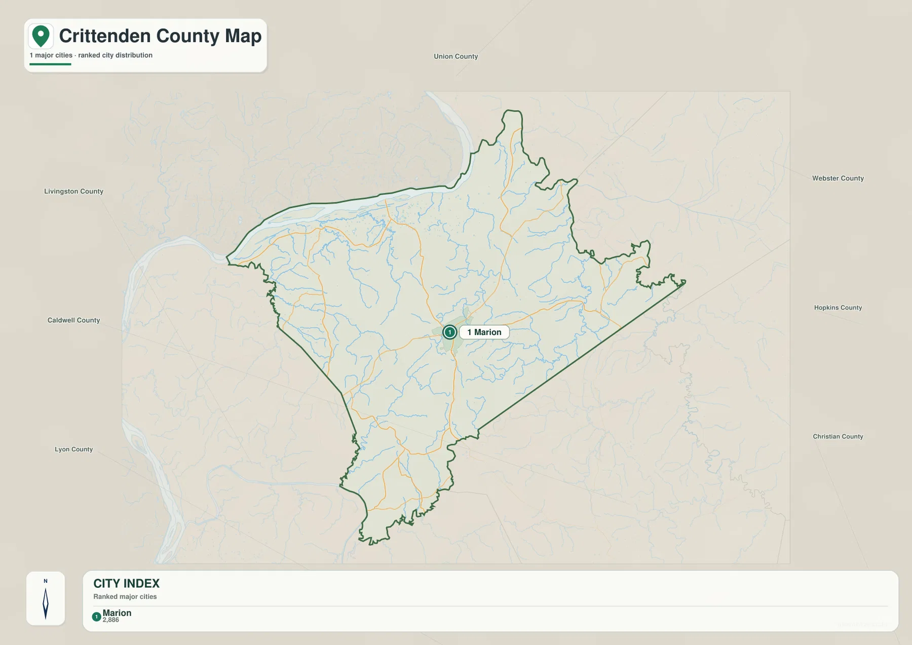
Neighboring county names provide additional orientation. Union County is labeled to the north, Webster and Hopkins counties to the east, Christian County to the southeast, Lyon and Caldwell counties to the southwest and west, and Livingston County to the northwest. Those labels show where Crittenden County sits within the broader western Kentucky county pattern without requiring a separate statewide map.
This simplified view is useful when the goal is to show Marion’s location in a presentation, classroom handout, or quick regional overview. It is not the right map for finding Tolu, Crayne, a specific state route, or a named creek because those features have been intentionally minimized. Switching between the city map and the general map gives both a clean overview and the detailed context.
Once Marion is fixed as the center, the other maps become easier to understand. The Ohio River lies toward the northwest, several creek valleys cut across the interior, and the higher relief becomes stronger through parts of the central and southern county. The city map therefore works as a simple geographic anchor rather than a complete settlement inventory.
Ohio River lowlands, Crooked Creek, and a web of smaller lakes and streams
The Ohio River dominates the northwestern edge of the terrain-and-water map. Barnett Lake and Bennett Lake are labeled near the river side, while Hurricane Creek and Caney Fork extend inland. This combination of a major river, small lakes, and short tributary valleys gives the northwest a distinctly different appearance from the hillier interior.
Crooked Creek is one of the strongest named interior features, running through the central part of the county. City Lake appears nearby, providing another easy landmark close to the Marion-centered portion of the map. The creek valleys help explain why some roads change direction frequently: the lowest ground often offers a more practical path through the surrounding hills.
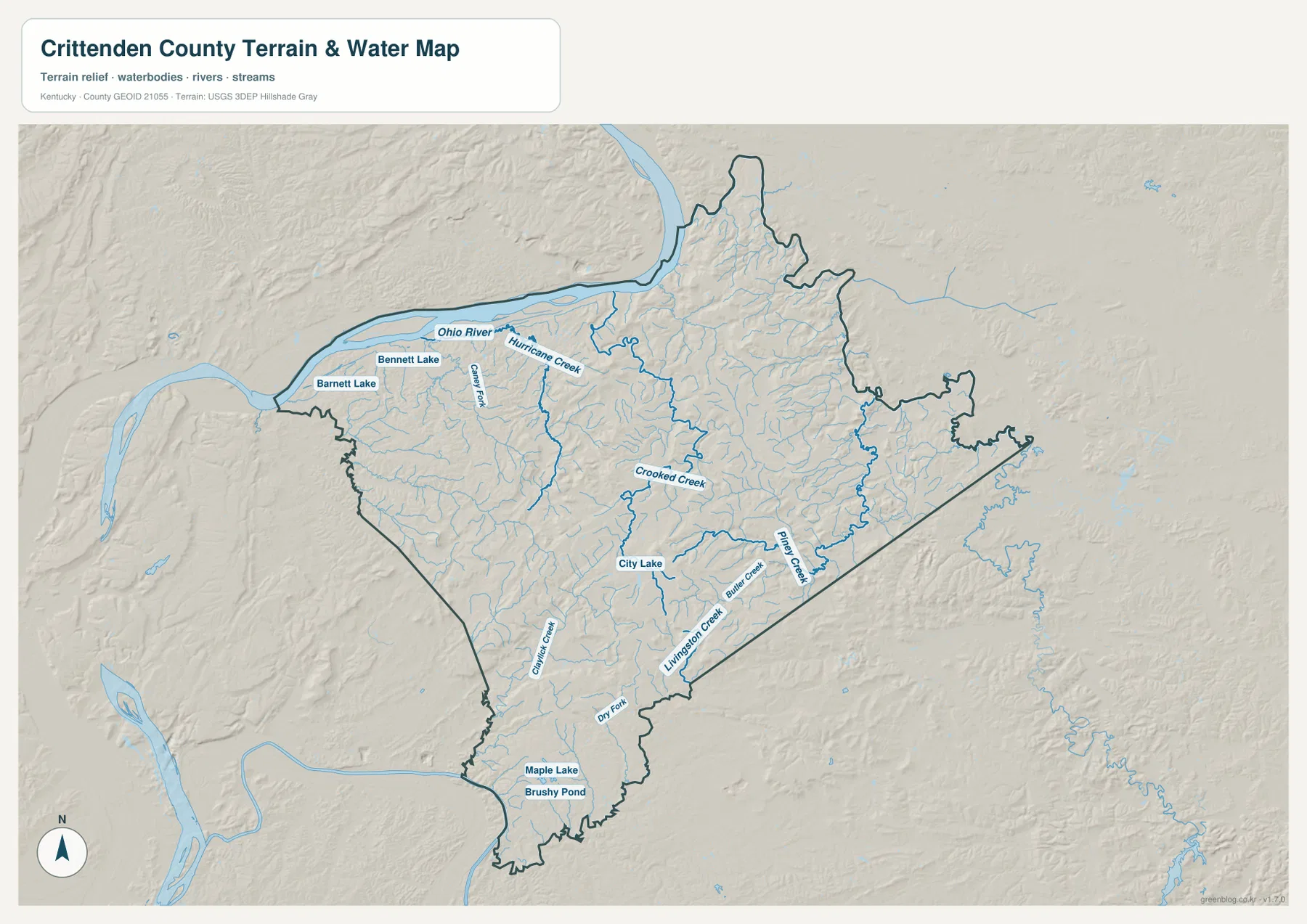
Piney Creek and Livingston Creek are prominent on the eastern and southeastern side, with smaller tributaries branching from them. Farther south and southwest, Dry Fork and other small channels continue through the narrowing part of the county. Maple Lake and Brushy Pond provide additional water references near the southern end.
The shaded terrain beneath the water network is useful because it shows that the streams are not crossing a flat surface. Crooked Creek and Livingston Creek follow lower corridors between ridges, while the surrounding terrain rises in repeated narrow bands. Comparing this map with the road map makes the curving route pattern much easier to understand.
This layer is a geographic water reference, not a flood map or navigation chart. River stages and creek conditions change with weather, and the existence of a lake or stream label does not establish public access. Boating, fishing access, flood safety, and private-property questions require current information from the responsible agency or land manager.
The City of Marion describes Marion as the county seat south of the Ohio River, which matches the relationship visible in the supplied maps. Local tourism information also provides context for the Marion area. Those sources are useful for place background, while the map set is better for seeing how the city, river edge, and smaller watercourses fit together.
A 98–254 meter county where low river ground gives way to interior hills
The elevation map reports an actual range of about 98 to 254 meters, with a mean near 145 meters. Green tones mark lower ground, and yellow through brown tones indicate higher terrain. The lowest broad area is concentrated near the Ohio River side and along several creek valleys, while the central and south-central interior contains much more tightly packed hill relief.
The strongest higher terrain appears south and southeast of the Marion area, where several ridge groups rise above 200 meters. Narrow lower valleys separate those ridges, creating substantial local contrast over short distances. With more than 150 meters between the low and high ends of the county range, Crittenden County is not uniformly flat even though its absolute elevations are modest compared with eastern Kentucky.
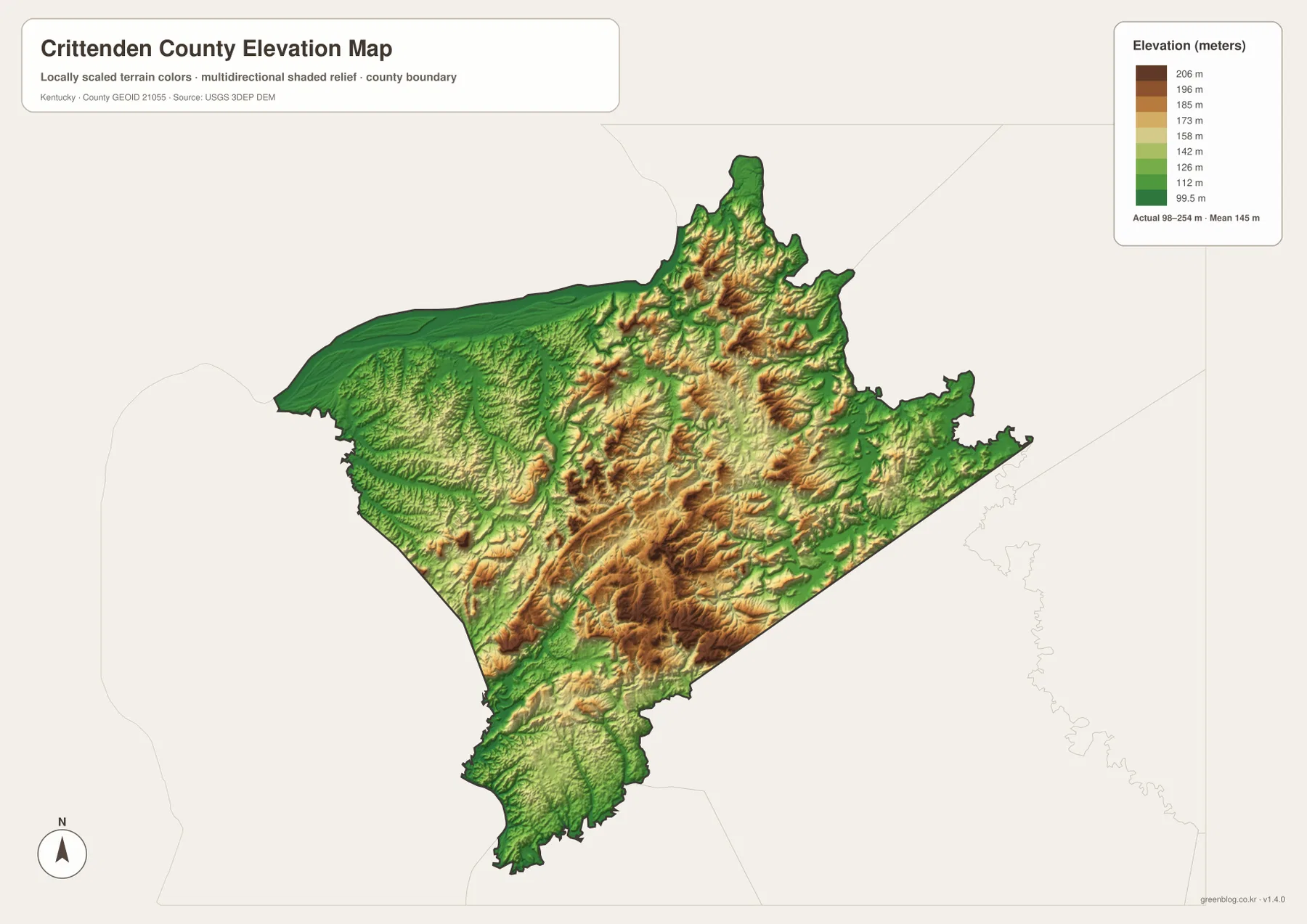
The northern interior also contains rolling relief. Moving inland from the river, green lowlands give way to narrow ridges and creek valleys, and the northeastern section includes additional higher ground. The Hurricane Creek area and neighboring tributaries occupy lower cuts between those ridges, a relationship that is easier to see when the water and elevation maps are compared.
The county’s southern extension becomes lower again in several valley sections, but small ridges still interrupt the landscape. That mixture prevents a simple one-word description such as “flat” or “hilly” from working for the whole county. The northwest river side, the central uplands, and the southern valleys each have a different visual character.
Roads in the southern half reflect that terrain. Routes such as KY 91, KY 855, and KY 902 follow or cross valleys instead of holding a straight course for long distances. Around Marion, by contrast, several major routes are able to meet within a broader central setting, which helps explain why the city functions as the county’s clearest road reference.
The elevation colors are intended for county-scale comparison only. They do not provide the exact elevation of a house, parcel corner, bridge, or construction site and should not be used as engineering measurements. Detailed elevation work should rely on USGS 3D Elevation Program data or professional surveying.
Matching the map to the question you are trying to answer
Start with the general county map when you need the fullest combination of place names, numbered roads, county boundary, and surrounding context. It is the best choice for tracing U.S. 60 or U.S. 641 through the county, locating Marion relative to Tolu and Crayne, or seeing how the road network approaches the Ohio River side.
Choose the city map when a clean view of Marion and neighboring counties matters more than route detail. Choose the terrain-and-water map for the Ohio River, Crooked Creek, Piney Creek, Livingston Creek, City Lake, and the smaller lakes and ponds. The elevation map is the clearest option for comparing low river-facing ground with the higher interior ridges and for seeing the county’s 98–254 meter range.
Using the general, water, and elevation maps together adds the most context. A bend in a road may correspond to a creek valley, and a creek valley may show up as a green low strip between higher ridges. That comparison is more informative than treating each layer as an isolated graphic because the same landscape controls all three patterns.
The ZIP below contains the original high-resolution JPG versions of all maps shown on this page. Each image is 3638 × 2572 pixels, which is better for printing and close label inspection than the smaller WebP files used in the article. They work well for education, personal reference, presentations, and regional planning, while legal, emergency, engineering, and live travel decisions should be checked against current official sources.
Frequently Asked Questions
Which map should I use to find Marion and the main numbered roads?
Use the general county map. It shows Marion together with U.S. 60, U.S. 641, KY 91, KY 297, KY 365, and other routes, while also retaining smaller references such as Tolu and Crayne. If you only need to show where Marion sits inside the county, the city map is cleaner.
What does the map set show about the Ohio River side of Crittenden County?
The Ohio River touches the northwestern edge, where the elevation map also shows some of the county’s lowest broad terrain. Barnett Lake, Bennett Lake, Hurricane Creek, and Caney Fork appear near or inland from that side, while the central and southern interior becomes hillier. The supplied elevation range is about 98–254 meters with a mean near 145 meters.
What is included in the downloadable ZIP?
The ZIP contains high-resolution JPG originals corresponding to the county map, city map, terrain-and-water map, and elevation map shown in the article. Each file is 3638 × 2572 pixels, making the originals more suitable for print and close label inspection than the smaller WebP display images.
Map File Information
The original Crittenden County maps used on this page are packaged as high-resolution JPG files. Their larger size is better for printing and close inspection of road numbers, creek names, and terrain details than the WebP images displayed in the article.
- Included Files: county map, city map, terrain and water map, elevation map
- File Type: JPG
Related Maps
Sources and references
For local context, see the City of Marion official website and Marion, Kentucky Tourism. Administrative boundary data are available from U.S. Census Bureau TIGER/Line Shapefiles, hydrography from USGS National Hydrography, and terrain data from the USGS 3D Elevation Program. Current road status, water levels, access rules, and safety information should be confirmed with the responsible agency.
Green Map creates custom-edited map images using open geographic data sources such as geoBoundaries, Natural Earth, OpenStreetMap, and government open data. These maps are edited visual materials, not raw data files, and are provided for education, documents, presentations, and graphic reference.