Clinton County sits in southern Kentucky with Albany as its clearest road and settlement reference point. The county is framed by major water features in two directions: Lake Cumberland reaches into the northern edge, while Dale Hollow Lake and the Wolf River define part of the southwest. Between them, numbered roads cross a landscape of branching creeks, narrow valleys, and higher ridges that become especially pronounced toward the east and southeast.
This page explains the county boundary and road network, Albany’s position, the water system between the two reservoirs, and the county’s mapped elevation range of roughly 167 to 544 meters. High-resolution JPG versions of the same maps are available in a downloadable ZIP for printing or closer label inspection. These graphics are reference maps for geographic orientation, not substitutes for live navigation, legal boundary research, flood determinations, or survey-grade elevation work.
Table of Contents
Albany as the road anchor inside Clinton County
The general county map makes Albany the easiest place to use as an anchor. It lies south of the county’s midpoint, where several numbered routes converge or pass nearby. Route 127 forms a prominent north-south connection, while 558 and 350 help define the local road pattern around Albany. Farther east, 90 and 829 cross the interior, and routes 696, 969, 968, and 415 serve the southeastern side.
The western half has its own network, including 734 in the northwest and 639, 553, and 738 farther south and west. Instead of forming a rigid grid, many of these roads bend with the terrain. That pattern is especially noticeable near the lake-cut northern edge and in the hillier east, where valleys and ridges create more indirect travel corridors than a straight-line view would suggest.
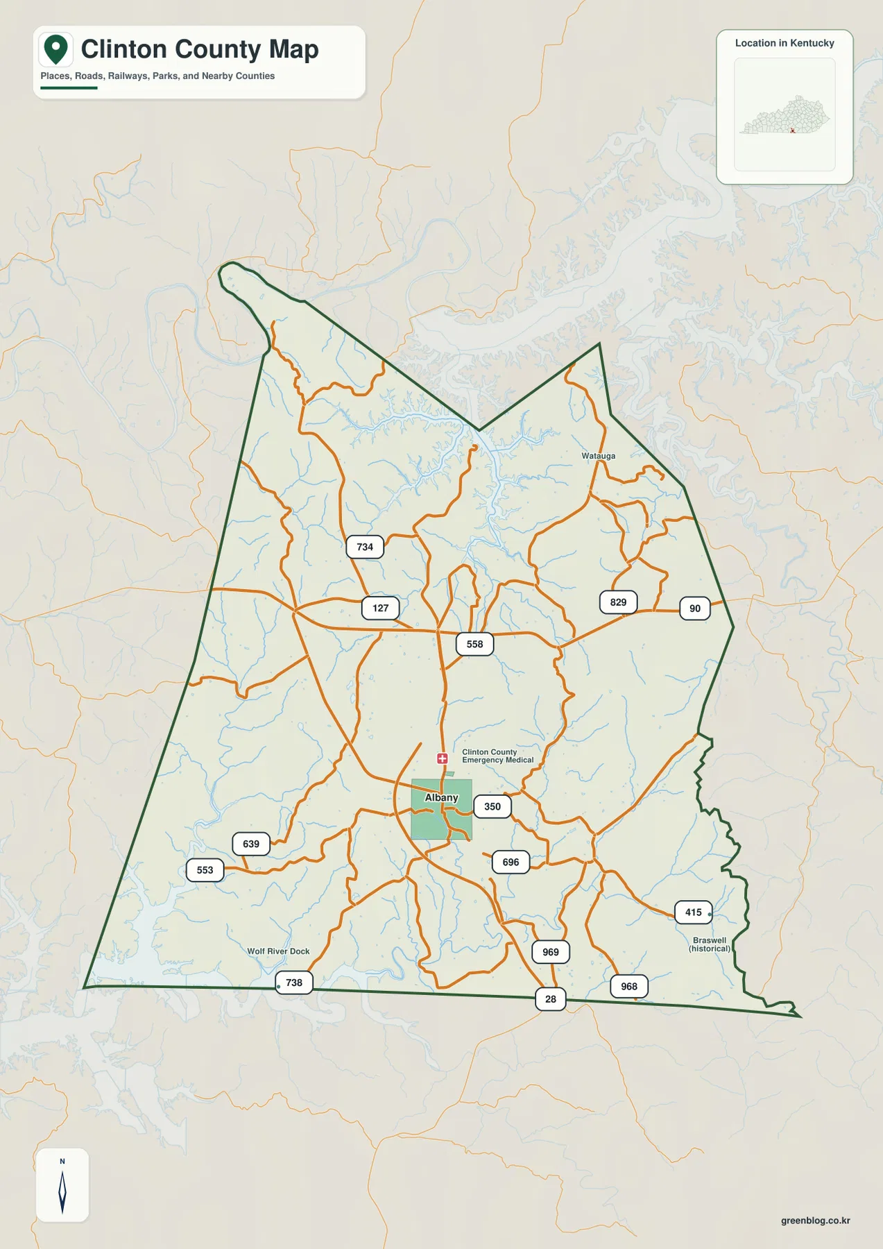
A few smaller labels add useful orientation. Watauga appears in the northeastern interior, Wolf River Dock is marked toward the southwest, and Braswell is shown as a historical place in the southeast. These names help distinguish different parts of the county, but the map does not attempt to label every local road, community, driveway, or access point.
The county outline also explains why the road pattern changes from one side to another. The north is broken up by the Lake Cumberland shoreline and connected valleys, while the long southern edge sits near Kentucky’s border with Tennessee. Albany occupies the southern half of the county, so a trip from town to the northern reservoir arms covers more terrain than a quick glance at the county shape might suggest.
For practical map reading, the general map works best when the question is directional: which route heads toward the eastern hills, how Albany connects to the northern part of the county, or where a smaller place sits relative to the county boundary. Current driving conditions, closures, private access, and address-level navigation should still be checked with current transportation or navigation sources.
A city index centered on one primary place
The city map strips away most of the road labels and highlights Albany as the single ranked major city in this visualization. That simpler design makes the city’s position inside the county easier to understand. Albany sits noticeably south of center rather than at the geometric middle, leaving a broad area of creeks, hills, and lake approaches to the north.
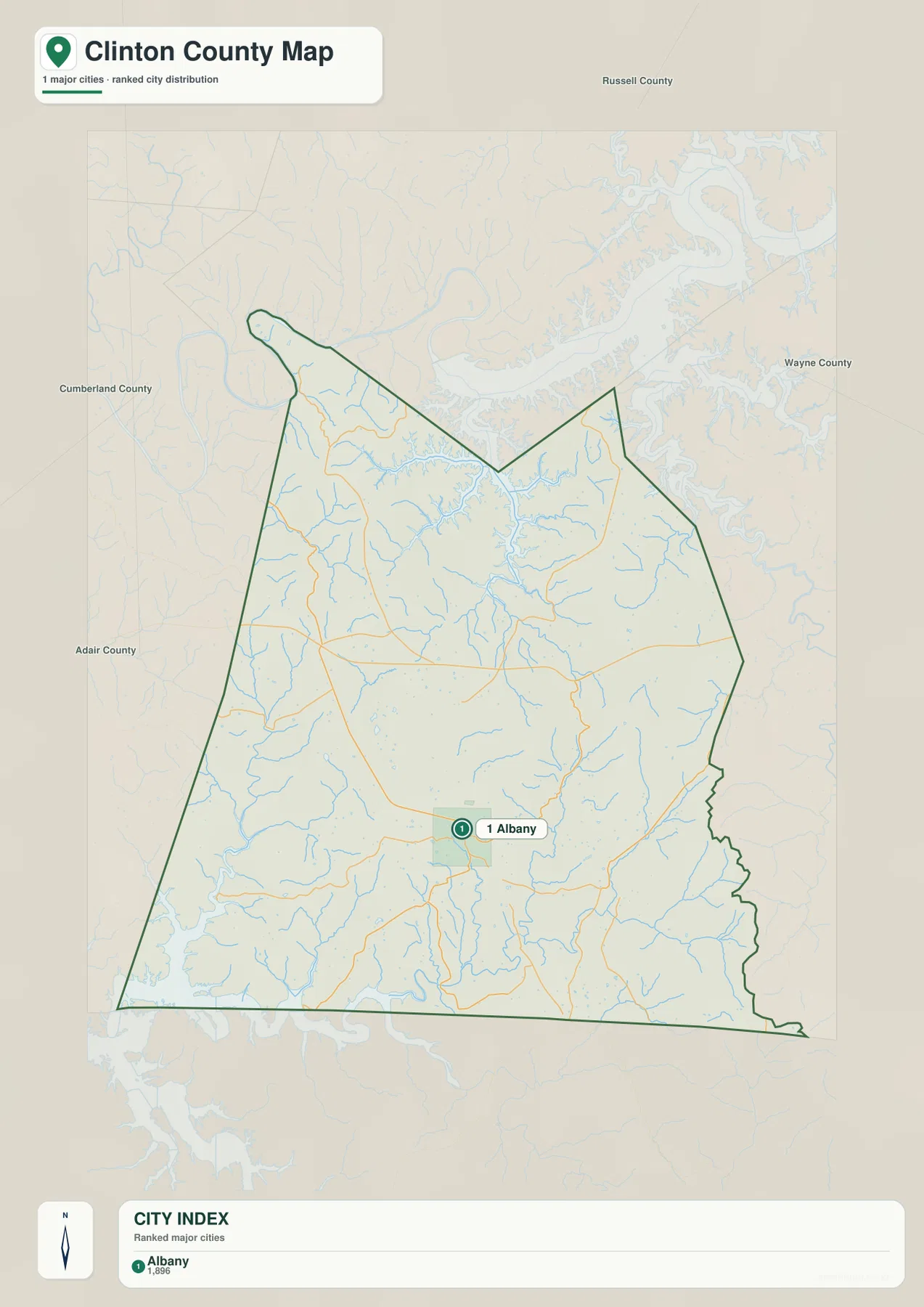
Russell County is labeled to the north, Wayne County to the east, and Cumberland and Adair counties to the west. Those surrounding names are useful for regional orientation because they place Clinton County within south-central Kentucky without cluttering the page with every road or small community. The map is therefore a locator first, not a detailed transportation chart.
Smaller places such as Watauga and Wolf River Dock remain important on the general map even though they are not emphasized here. That difference is intentional. A user preparing a simple county overview may prefer the city map, while someone trying to understand actual movement through the county will need the road map as well.
Albany also provides a useful reference when comparing the natural-resource maps. Lake Cumberland lies well to the north, Dale Hollow Lake and the Wolf River are toward the southwest, and the higher eastern ridges sit on the opposite side of the county. Establishing the city first makes the more complex stream and elevation patterns much easier to interpret.
Waterways between Lake Cumberland and Dale Hollow Lake
The terrain-and-water map shows one of Clinton County’s most distinctive geographic relationships: the county lies between Lake Cumberland to the north and Dale Hollow Lake to the southwest. Lake Cumberland sends long, branching arms into the northern edge, while the Wolf River leads toward Dale Hollow Lake along the lower-left side of the map. This two-reservoir setting gives the county very different shoreline and valley forms in different directions.
Big Willis Creek is labeled in the northwestern interior, and Indian Creek runs northward toward the Lake Cumberland side. Hurricane Creek appears farther east. Numerous shorter tributaries feed the larger water bodies from narrow side valleys, creating a dense pattern that is much easier to understand when the shaded terrain remains visible behind the blue waterways.
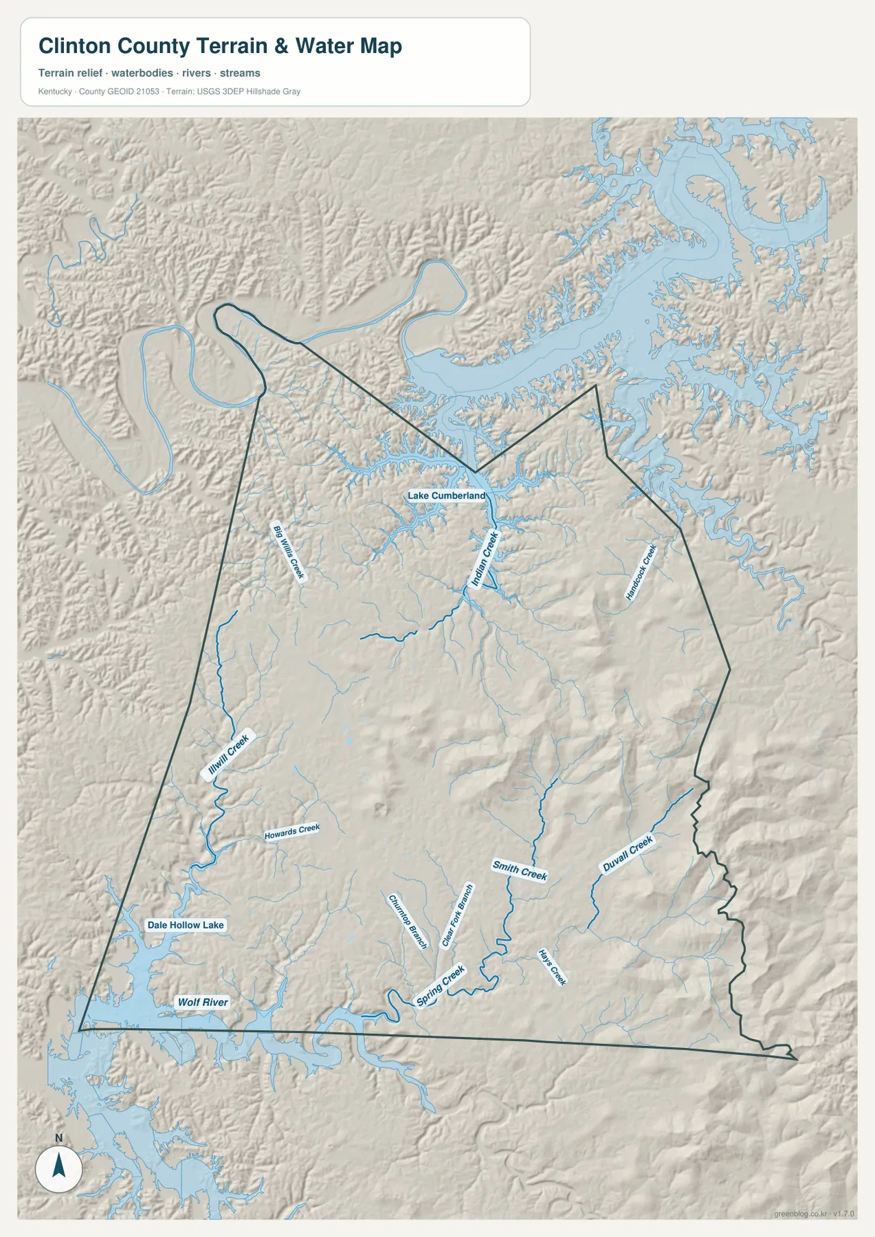
The southwestern half contains another set of useful landmarks. Illwill Creek and Howards Creek are labeled west of the county’s center, while Spring Creek, Green Fork Branch, and Cinnamon Branch appear farther south. Smith Creek, Duval Creek, and Moss Creek identify additional valleys on the eastern and southeastern side. Together they show that water drains through many separate hollows rather than through one simple central channel.
The water map also helps explain road bends. Where a creek occupies the lowest part of a valley, roads frequently follow the same general corridor or cross from one valley to another at a lower point. That relationship is visible around several of the named creeks, although the map should not be used to decide whether a road is currently open or whether a stream crossing is safe.
Local tourism sources describe Clinton County as a place between Lake Cumberland and Dale Hollow Lake, a description that matches the supplied maps closely. For a visitor, the easiest mental model is to place Albany in the interior, Lake Cumberland to the north, and the Wolf River-Dale Hollow Lake system to the southwest. From there, the smaller creeks provide local detail.
This layer is not a flood map, navigation chart, water-quality report, or property-access map. Reservoir levels change, stream conditions respond to weather, and recreation rules can vary by location. Anyone making a safety, boating, fishing-access, or flood-related decision should consult the responsible agency for current information.
A 167–544 meter landscape with the highest ridges in the east
The elevation map reports an actual range of about 167 to 544 meters and a mean elevation near 299 meters. Lower green tones are widespread in the western valleys and around several water corridors, while yellow, orange, and brown tones become much more common toward the eastern and southeastern side. The difference is substantial enough that Clinton County does not read as one uniform rolling surface.
The most striking high ground is concentrated east and southeast of Albany. Multiple ridge groups rise above 400 meters, with some points exceeding 500 meters. Narrow lower valleys cut between those ridges, producing a strong local contrast. That pattern is consistent with the curving roads and branching streams seen in the other maps.
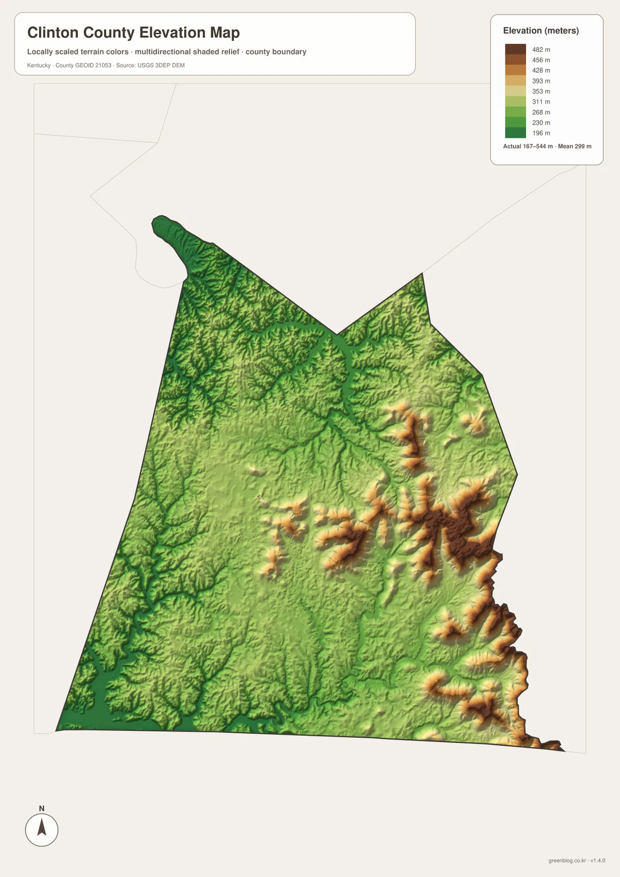
The north is not flat either. Tributary valleys leading toward Lake Cumberland create repeated bands of lower and higher terrain, while the southwest drops toward the Wolf River and Dale Hollow Lake before rising again inland. This means two places at similar map distance can have very different road approaches if a ridge sits between them.
Comparing the elevation map with the road map makes the eastern network easier to understand. Routes 90 and 829 cross hillier country, and the southeastern roads around 415 and 968 also pass through more broken relief than the Albany area. Albany itself occupies a broader, lower setting where several routes can meet without the same concentration of steep ridge forms.
The elevation colors are intended for county-scale comparison. They do not provide the exact elevation of a house, parcel corner, bridge, trail point, or construction site, and they should not be treated as engineering measurements. Detailed USGS elevation data or professional surveying is the appropriate source when exact height or slope is required.
Choosing the right Clinton County map for the question
Use the general county map when you need Albany, the county boundary, major numbered routes, and smaller place labels in one view. It is the strongest option for understanding how 127, 90, 558, 350, and other routes relate to the county’s shape. It also gives enough surrounding context to connect a road question with a lake or creek location.
Use the city map when the main task is simply to show where Albany sits in Clinton County and how the county relates to its neighbors. Because the design removes most secondary detail, it works well for a clean presentation or basic regional overview. It is not the best choice for finding a minor road or water feature.
The terrain-and-water map is the better choice for Lake Cumberland, Dale Hollow Lake, the Wolf River, and named creeks such as Big Willis, Indian, Hurricane, and Spring. The elevation map is more direct when the topic is relief: it shows the 167–544 meter range and the concentration of high ridges in the east and southeast. Looking at those two together is especially useful for understanding why streams and roads follow particular valleys.
For printing or close inspection, the ZIP below contains the original high-resolution JPG files. Their larger dimensions make route numbers, stream names, and shaded relief easier to examine than the smaller WebP images used in the article. The maps are useful for education, trip planning, regional orientation, and print reference, but legal, emergency, engineering, and real-time travel decisions should always be checked against current official sources.
Frequently Asked Questions
Which map is best for finding Albany and the main roads?
Start with the general county map. It places Albany together with routes 127, 90, 558, 350, and other numbered roads, while also showing the county boundary and smaller references such as Watauga and Wolf River Dock. The city map is cleaner if Albany’s position is the only information you need.
How do Lake Cumberland and Dale Hollow Lake relate to Clinton County?
Lake Cumberland reaches into the northern edge of the county, while Dale Hollow Lake lies along the southwest near the Wolf River. The terrain-and-water map shows both systems along with Big Willis Creek, Indian Creek, Hurricane Creek, Spring Creek, and other tributaries, making it the best map for comparing the county’s two major water settings.
How much elevation change is shown in Clinton County?
The supplied elevation map shows an actual range of about 167 to 544 meters and a mean near 299 meters. The highest ridge concentrations are in the east and southeast, while lower valleys follow many water corridors and reservoir approaches. These values are appropriate for county-scale comparison, not precise site elevation or survey work.
Map File Information
The original Clinton County maps used on this page are packaged as high-resolution JPG files. Each image is 3638 × 2572 px, making the set better suited to printing and close label inspection than the smaller WebP versions shown in the article.
- Included Files: county map, city map, terrain and water map, elevation map
- File Type: JPG
Related Maps
Sources and references
County context can be checked with the Kentucky.gov Clinton County profile and the Clinton County Tourist Commission. Administrative boundaries are available from U.S. Census Bureau TIGER/Line Shapefiles, hydrography from USGS National Hydrography, and terrain data from the USGS 3D Elevation Program. Current road conditions, reservoir levels, access rules, and safety information should be confirmed with the responsible agency.
Green Map creates custom-edited map images using open geographic data sources such as geoBoundaries, Natural Earth, OpenStreetMap, and government open data. These maps are edited visual materials, not raw data files, and are provided for education, documents, presentations, and graphic reference.