You can download the Rutherford County Tennessee Map files on this page as one ZIP containing high-resolution JPG versions of the county, city, water, and elevation maps. Murfreesboro is the main reference point, with Smyrna and La Vergne extending the county’s largest urban connection toward the northwest and Eagleville sitting apart in the southwest. Separate sheets show the Stones River forks and the change from lower central terrain to higher ridges along several county edges. The files are prepared for A3 printing, classroom work, presentations, and general county reference.
Rutherford County is easier to understand when the cities, roads, water, and relief are viewed as parts of the same landscape. Murfreesboro occupies the central-northern area and acts as the county seat. Smyrna and La Vergne lie along the same broad northwest direction, while Eagleville is much farther southwest. That arrangement means the county does not have one compact circle of development around the seat; its largest urban corridor stretches away from Murfreesboro in a distinct direction.
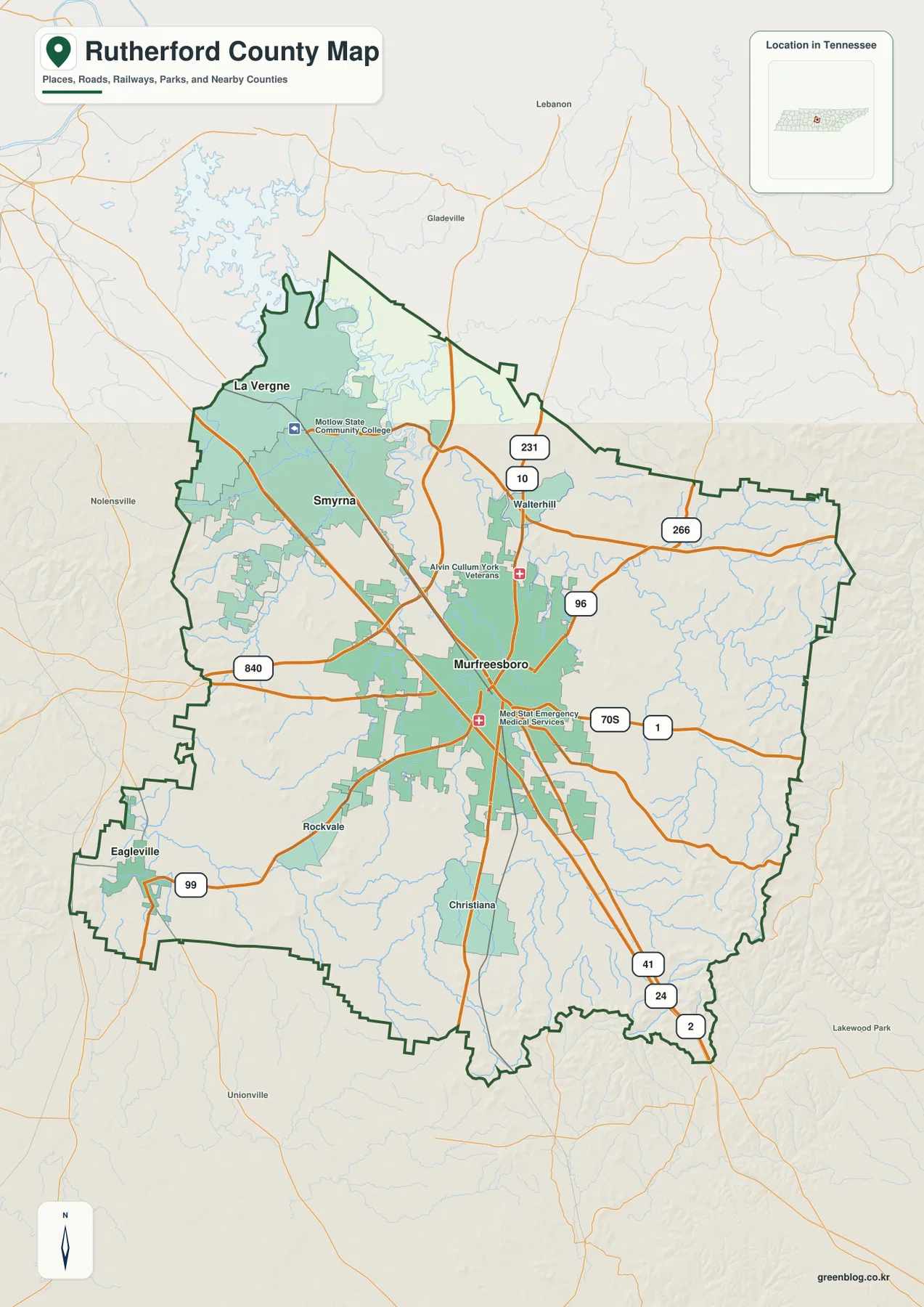
Table of Contents
Murfreesboro anchors the road network while I-24 points toward Smyrna and La Vergne
Murfreesboro sits just north of the county’s center and is where several major routes become easy to compare. I-24 passes through the city and continues northwest toward Smyrna and La Vergne. I-840 crosses the western side of the county, US 70S leaves Murfreesboro toward the east, and US 231 provides a strong north-south reference. US 41 also helps trace the developed corridor between Murfreesboro and the cities to the northwest.
The tightest concentration of roads and built-up areas appears between Murfreesboro and Smyrna. I-24 follows that same direction and makes the relationship between the two cities obvious even before the city-ranking map is opened. La Vergne extends the pattern farther northwest toward the Davidson County side. Eagleville is different: it sits near the southwestern edge around route 99 and is separated from the main Murfreesboro–Smyrna–La Vergne corridor by a much larger rural area.
East of Murfreesboro, route labels 96 and 266 provide additional references, while 231 and 10 appear toward the north. South of the city, Christiana is shown along a route corridor with 41, 24, and 2 labels near the lower boundary. The reference map also marks local institutions in Murfreesboro, including Middle Tennessee State University and medical facilities, which helps distinguish the dense urban center from the surrounding county road network.
Four ranked cities reveal a strong northwest urban corridor
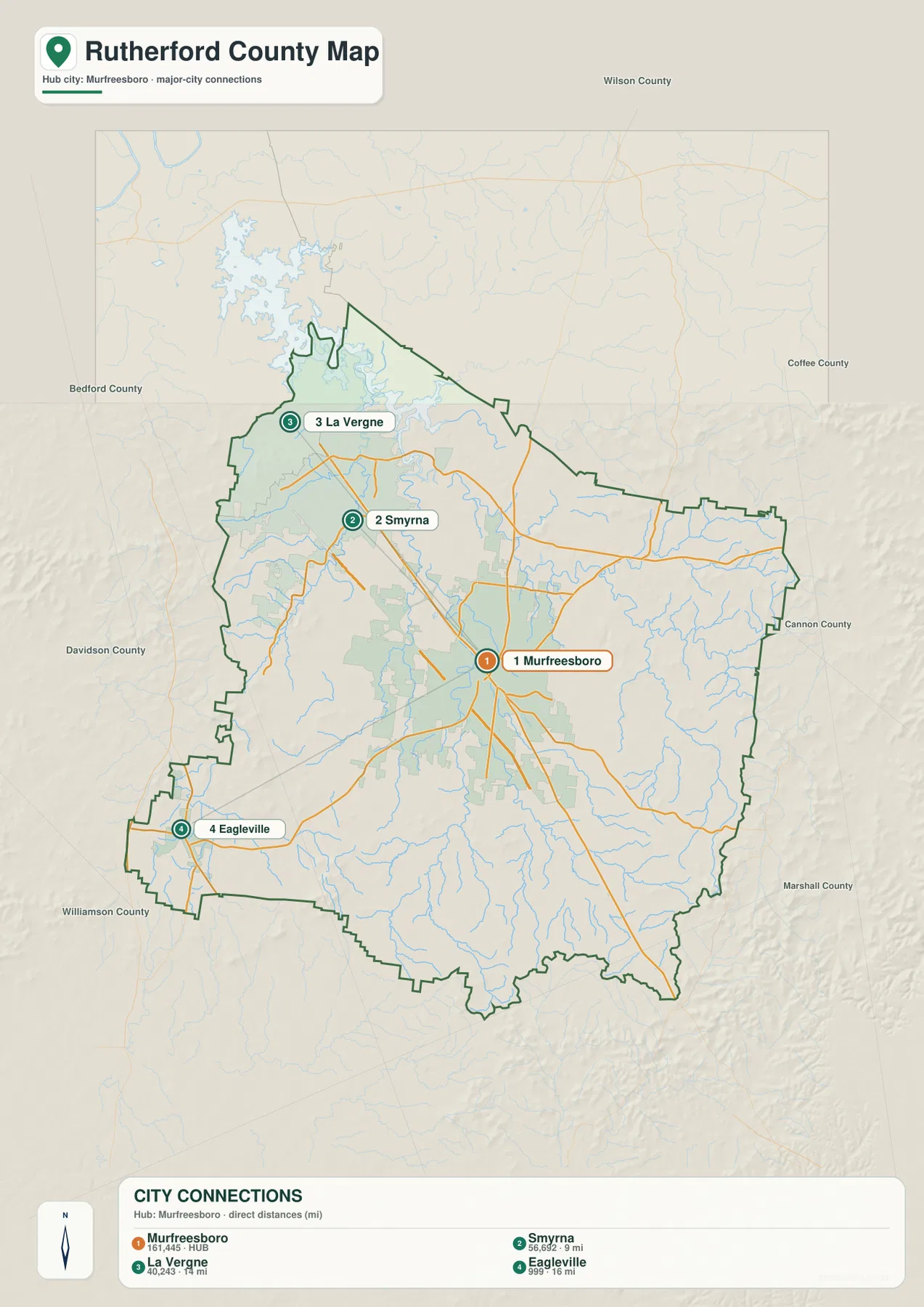
The city sheet ranks Murfreesboro first at 161,445. Smyrna is second at 56,692 and is shown about 9 miles from the hub, while La Vergne is third at 40,243 and about 14 miles away. Eagleville is fourth at 999 and roughly 16 miles from Murfreesboro. These are the figures printed on the supplied city map and are most useful for comparing the mapped cities with one another rather than substituting for countywide Census totals.
The important feature is not simply the ranking. Murfreesboro, Smyrna, and La Vergne line up in the same general northwest direction, with I-24 reinforcing the connection. Eagleville sits away from that line in the southwest and has a much smaller mapped population. This makes Rutherford County visually different from a county where several towns of similar size are distributed evenly around a central seat.
The city map also labels surrounding counties, including Wilson, Coffee, Cannon, Marshall, Williamson, Davidson, and Bedford. Those outer names help explain why an edge city should not be read as though it were deep inside Rutherford County. La Vergne is close to the northwestern side, while Eagleville is close to the southwestern edge. Murfreesboro remains the interior anchor, but the county’s urban connections reach several different neighboring directions.
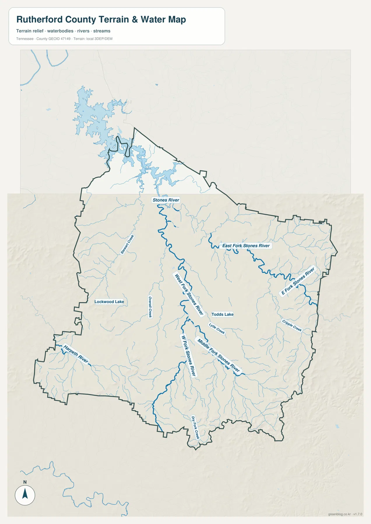
East, West, and Middle Fork Stones River divide the county into connected creek valleys
Stones River is the defining water name on the supplied water sheet. The main river is labeled in the north-central area, while East Fork Stones River extends across the eastern side and West Fork Stones River follows a long route through the central and southern part of the county. Middle Fork Stones River appears as another important branch near the center. Rather than one simple river line, the map shows several forks approaching the Murfreesboro area through separate valleys.
Overall Creek lies west of the central river branches, and Lytle Creek is labeled east of West Fork Stones River. Chappie Creek provides another eastern reference, while Dry Fork Creek runs near the southern edge. In the southwest, Harpeth River is shown around the Eagleville side. That last feature is especially useful because it shows that not every stream in Rutherford County belongs to the same Stones River branch system.
A broad reservoir surface is visible near the northwestern boundary, and smaller named waters such as Lockwood Lake and Todds Lake appear inside the county. The combination of reservoir arms, river forks, and short creeks makes the north-central and central drainage look much more intricate than the general road map suggests. This water map is intended for locating waterways and comparing valleys; it is not a flood-warning, navigation, or current water-level product.
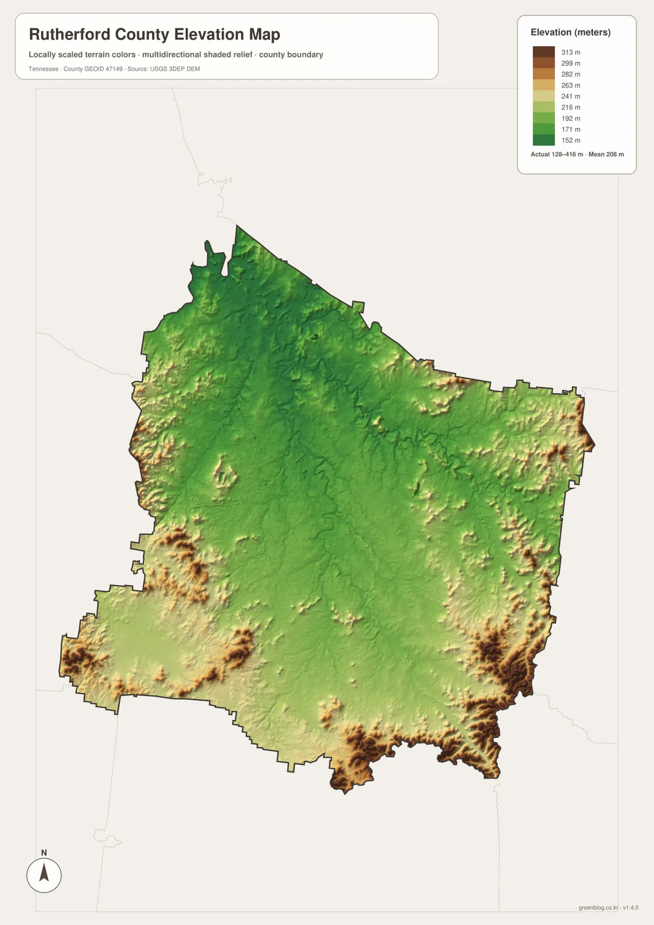
Elevation ranges from about 128 to 416 meters, with higher ridges around several county edges
The supplied elevation sheet shows an actual range of about 128 to 416 meters and a mean near 208 meters. Most of the central and north-central county is green, indicating comparatively low and gentle terrain. Yellow, tan, and brown relief becomes much stronger around the western edge, eastern edge, and especially the southeastern corner.
Murfreesboro occupies the lower central landscape, and the Stones River branches follow many of the same low corridors. The route toward Smyrna and La Vergne also remains relatively low, helping explain why the urban and highway connection can extend northwest without a major ridge barrier. The eastern and southeastern sides are more broken, with repeated hills and narrow valleys that stand out sharply from the central basin-like terrain.
The Eagleville side is not completely flat either. Creek valleys cross lower ground, while isolated higher ridges appear closer to the western and southwestern boundary. The map works well for comparing relative relief across the county, but it should not be used to determine survey elevation, exact property slope, or development suitability at an individual site.
County facts that put the maps in context
- Official name: Rutherford County, Tennessee
- County seat: Murfreesboro
- FIPS code: 47149
- Established: 1803
- 2020 Census population: 341,482
- July 2025 population estimate: 386,352
- 2025 Gazetteer area: 619.5 square miles of land and 4.5 square miles of water
- Elevation shown on this map: about 128–416 m, mean about 208 m
The 341,482 figure is the completed 2020 Census count, while 386,352 is a July 2025 estimate. They are different types of population measures and should remain labeled separately. The county’s 619.5 square miles of land also includes very different settings, from the dense Murfreesboro–Smyrna corridor to rural land around Eagleville and the higher ridges along the eastern and southern edges.
The county material supplied in the package identifies Rutherford County as established in 1803 and Murfreesboro as the county seat. The modern maps show that the administrative center is also the largest ranked city and a major road hub, but they also make clear that the county is not organized around Murfreesboro alone. Smyrna and La Vergne form a large separate extension of the urban corridor toward the northwest.
Choose the map by whether you need roads, cities, water, or relief
Start with the county reference map when you need Murfreesboro, Smyrna, La Vergne, Eagleville, major roads, and the county boundary on one sheet. It is the most useful view for explaining I-24, I-840, US 70S, US 41, and US 231 together. The city sheet is cleaner when the main question is how the four ranked cities relate to Murfreesboro and how far the outer cities sit from the hub.
Use the water map for Stones River and its East, West, and Middle forks, or for Overall Creek, Lytle Creek, Harpeth River, and the smaller lakes. The elevation sheet then explains why many of those streams occupy long green low corridors while the county margins contain higher ridges. Looking at water and relief together is especially useful around the eastern and southeastern side, where hills and drainage are more tightly interwoven.
The downloadable ZIP contains high-resolution JPG versions of all four maps and can be printed at A3 size while preserving the original proportions. Keep an untouched original if you plan to add route lines, arrows, or notes to a working copy. These are static reference maps, so current road closures, flood warnings, legal parcel boundaries, and construction conditions should be checked with the responsible agency.
Frequently Asked Questions
How close are Smyrna and La Vergne to Murfreesboro on the city map?
The supplied city sheet places Smyrna about 9 miles from Murfreesboro and La Vergne about 14 miles away in straight-line distance. Both lie in the same northwest direction and follow the broad I-24 urban corridor, which makes them more closely connected on the map than Eagleville in the southwest.
How is Stones River divided inside Rutherford County?
The water sheet labels the main Stones River along with East Fork, West Fork, and Middle Fork Stones River. The branches occupy separate valleys around Murfreesboro and the central county, with Overall Creek and Lytle Creek among the additional named tributaries. Harpeth River appears separately in the southwest near Eagleville.
Where is the highest terrain on the elevation map?
The strongest high relief appears along parts of the western and eastern boundaries and becomes especially prominent in the southeast. The displayed elevation ranges from about 128 to 416 meters, with a mean near 208 meters. Murfreesboro and much of the central county lie on comparatively lower terrain.
Map File Information
The ZIP contains high-resolution JPG versions of the county, city, water, and elevation maps. They are suitable for A3 printing, presentations, classroom material, and general location reference.
- Included Files: county, city, water, and elevation JPGs
- File Type: JPG files in one ZIP
Related Maps
- Alamo to Gadsden: A Crockett County Tennessee Map
- Altamont, Monteagle, and Plateau Valleys — Grundy County Tennessee Map
- Around Chattanooga: Hamilton County Tennessee Map
Sources and references
- Tennessee State Library and Archives — Rutherford County fact sheet
- Tennessee Department of Transportation — Rutherford County road reference
- U.S. Census Bureau QuickFacts — Rutherford County, Tennessee
- U.S. Census Bureau TIGER/Line boundary data
- USGS National Hydrography
- USGS 3D Elevation Program
Green Map creates custom-edited map images using open geographic data sources such as geoBoundaries, Natural Earth, OpenStreetMap, and government open data. These maps are edited visual materials, not raw data files, and are provided for education, documents, presentations, and graphic reference.