Jersey County sits in southwestern Illinois, north of the St. Louis area, with a broad rural interior and a very different river-edge landscape in the south and west. Jerseyville is the county seat and the clearest road hub on the supplied maps, while Grafton and Elsah occupy the lower edge near the great-river corridor. This page brings those relationships together through separate boundary-and-road, community, terrain-and-water, and elevation maps. You can also download the original high-resolution JPG map files in one ZIP when you need a larger view for printing, teaching, or local reference.
The county is easiest to understand by using Jerseyville as an interior reference point and then looking outward. Illinois Route 16 crosses the county from the Fieldon side through Jerseyville, U.S. 67 angles southeast from the county seat, and Illinois Route 100 follows the southern river edge past Grafton and Elsah. The western boundary is irregular where the landscape meets broad river and backwater areas, while several northern and eastern county lines are much straighter. That contrast between an interior road grid and a deeply cut river margin becomes even clearer on the water and elevation maps.
These are not four cosmetic versions of the same picture. The first map is best for roads, communities, county shape, and neighboring areas. The ranked-community map strips away some road detail so Jerseyville, Grafton, Elsah, Fieldon, Otterville, and Fidelity can be compared quickly. The terrain-and-water map names creeks and lakes that are difficult to notice on a general map, and the elevation map shows why the southwest feels so different from the gentler central and eastern interior.
Table of Contents
Jerseyville anchors the county’s interior road network
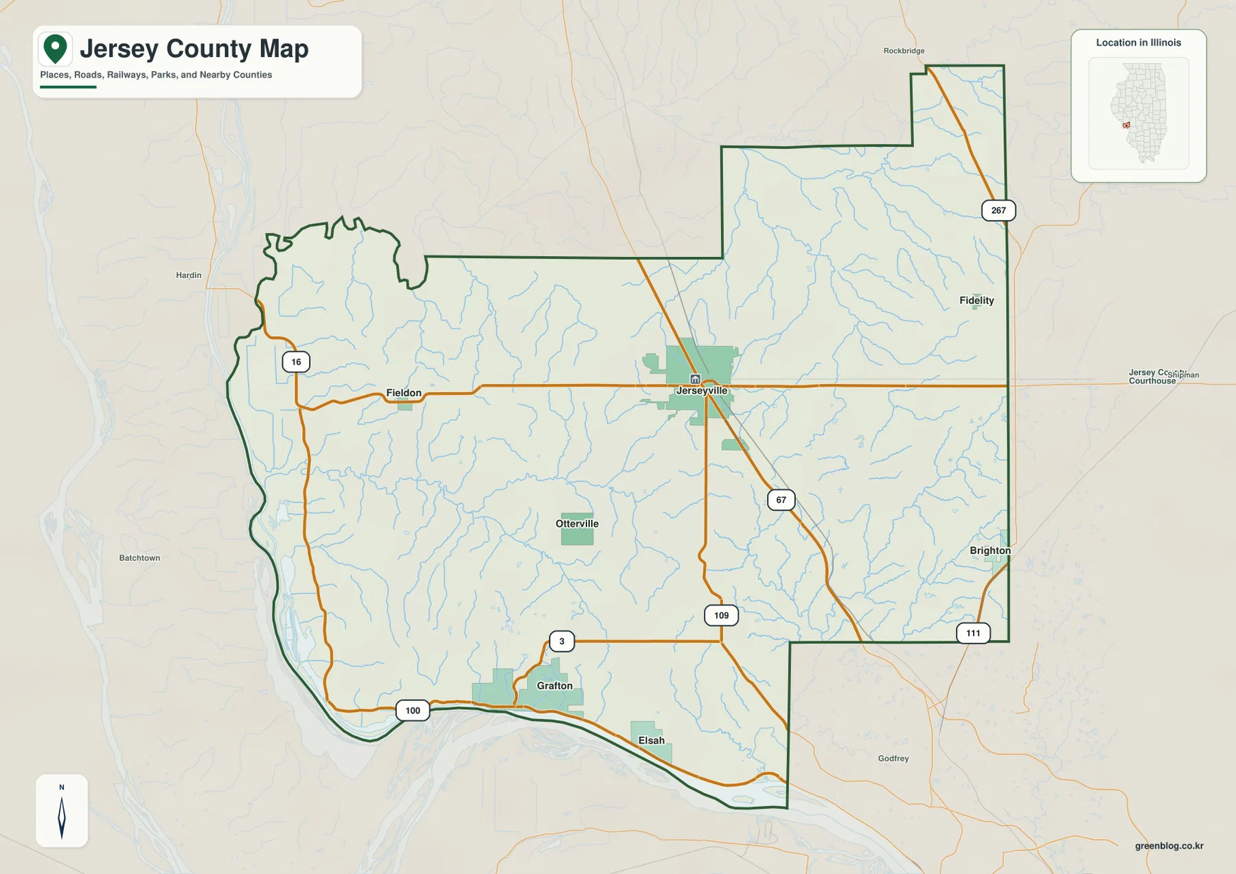
The general county map places Jerseyville near the middle of the road pattern. Illinois Route 16 approaches from the west through Fieldon and continues through the county seat, while U.S. 67 leaves the Jerseyville area toward the southeast. Illinois Route 109 runs south from the central part of the county, Route 267 appears near the northeastern extension, and Route 111 is visible near the eastern edge. Along the river side, Route 100 follows the bottom of the county through the Grafton area and past Elsah. The resulting pattern makes it possible to separate the central road hub from the much narrower travel corridor along the southern edge.
The county outline is also worth noticing before moving to the specialized maps. Jersey County has a protruding northeastern section, a long east side, and a much more sinuous western and southwestern edge. Calhoun County lies to the west, Greene County to the north, and Macoupin and Madison counties appear along the eastern side of the community map. Those neighboring labels help orient a reader who is looking at Jersey County without a full state map. They also explain why a road that appears close to an edge may actually lead toward a different neighboring county depending on direction.
Jersey County’s official government site describes the county as a predominantly rural area north of St. Louis on U.S. 67, with Jerseyville as the county seat and largest municipality. The map matches that description well: Jerseyville has the most prominent built-up symbol and sits where several important routes converge. Grafton, by contrast, is far to the southwest on the river corridor. Looking at both places on one map is useful because the county’s public life is not organized around a single landscape. The inland county seat and the river towns occupy distinctly different settings.
For a first-time visitor, the road map is the most practical starting point. It gives enough surrounding context to locate Fieldon to the west, Fidelity to the northeast, Brighton near the southeast, and Grafton and Elsah along the south. It does not attempt to show every local street or property boundary, so it should be treated as a county-scale reference rather than a navigation replacement. Its strength is the way roads, named places, streams, and the overall county shape remain visible at the same time.
Communities spread from Fieldon to the river towns rather than forming one cluster
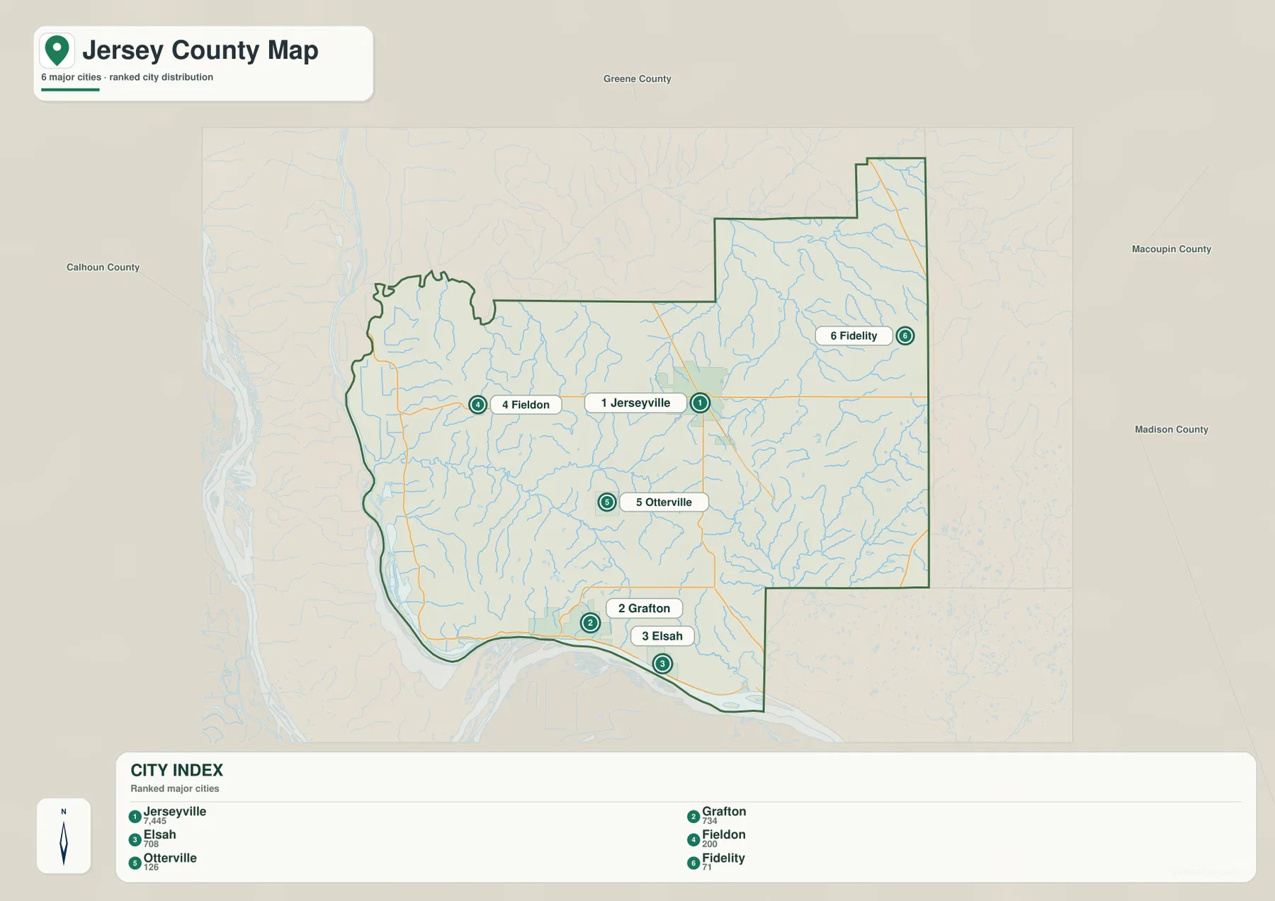
The community map makes the settlement pattern much easier to compare. Jerseyville is ranked first and stands near the center, while Grafton and Elsah sit close together along the southern edge. Fieldon is west of Jerseyville, Otterville lies in the southwestern interior, and Fidelity is separated from the others near the northeastern side. This distribution matters because a list of place names alone can make the county seem more compact than it is. On the map, the distance in direction between the inland communities and the river towns is immediately apparent.
The index printed on the supplied map lists Jerseyville at 7,445, Grafton at 734, Elsah at 708, Fieldon at 200, Otterville at 126, and Fidelity at 71. Those values are useful here as map labels for comparing relative size, not as a substitute for a current demographic table. The historic and administrative record also distinguishes different municipal forms within the county, so the map’s broad “city index” language should be read as a convenient ranking of mapped communities. What matters for this page is where those communities sit and how their positions relate to roads, water, and relief.
Grafton and Elsah form a particularly recognizable pair on the southern side. Route 100 runs through this river-edge corridor, and official Illinois sources identify the Grafton area with the meeting of the Illinois and Mississippi rivers. The Illinois Department of Natural Resources also places the Pere Marquette Visitor Center just north of that confluence. That broader river setting helps explain why the southern communities feel geographically separate from Jerseyville even though they are in the same county.
Fieldon and Fidelity demonstrate the opposite kind of separation. Fieldon lies along Route 16 west of the county seat, whereas Fidelity is near the northeast. Otterville sits south and west of Jerseyville without the same large road concentration visible around the county seat. When planning a classroom exercise, a local-history handout, or a simple county orientation graphic, this map is often cleaner than the full road map because it keeps the six named communities visually prominent.
Otter Creek and Piasa Creek reveal a divided drainage landscape
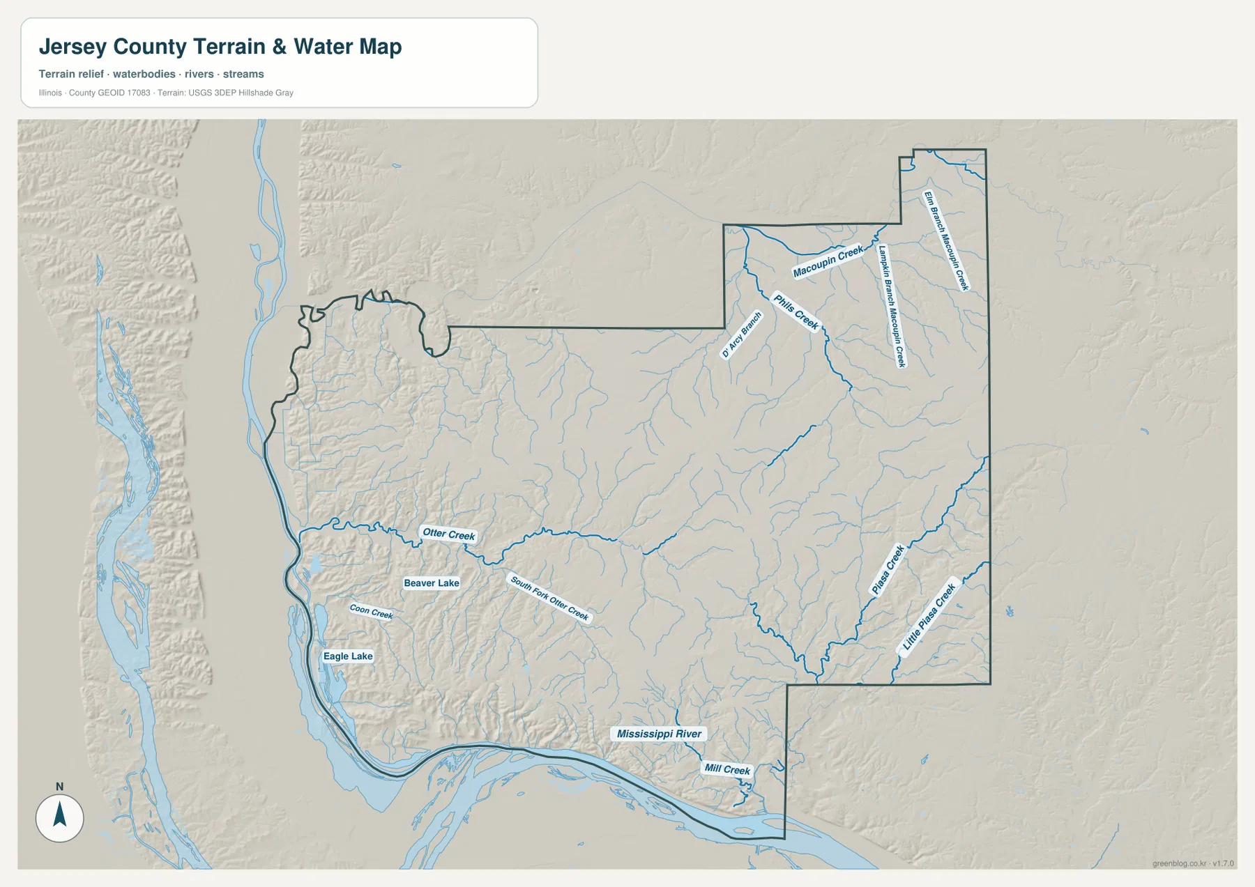
Water is not confined to the county’s outer edge. In the western half, Otter Creek runs toward the broad lowland near the river, with South Fork Otter Creek joining the same general system. Coon Creek, Beaver Lake, and Eagle Lake are labeled farther southwest. The shaded terrain behind those blue lines shows many short valleys descending toward the larger river and backwater areas. This makes the southwest look very different from a simple flat floodplain: low water-adjacent ground sits beside strongly dissected hills.
Eastern Jersey County has a different set of named streams. Piasa Creek and Little Piasa Creek stand out in the east and southeast, cutting through the interior before leaving the county. In the northeastern extension, the map labels Macoupin Creek, Pils Creek, an East Branch of Macoupin Creek, and smaller tributaries. These streams make it clear that the county does not drain as one uniform surface toward a single visible channel. Multiple creek systems occupy different corners, and each follows its own set of shallow or deeply incised valleys.
The Mississippi River label appears along the southern edge, where the map also shows broad water surfaces and low terrain. Around the southwest, the water network becomes visually dense because river channels, backwaters, lakes, and tributary mouths lie close together. That is the best place on the map to compare natural features with the Route 100 corridor seen on the road map. The road remains close to the river, while the land immediately inland rises into more rugged terrain.
This is a reference map of waterways and terrain, not a flood-risk, navigation, parcel, or legal-water-boundary product. A blue channel on the page does not tell a reader how deep the water is, whether a particular property is in a regulatory floodplain, or whether a route is safe for boating. For those questions, current agency products are necessary. The value of this map is county-wide orientation: it shows where named streams lie, which parts of Jersey County have dense drainage, and how river lowlands meet the hills.
Readers who need the underlying hydrography can follow the U.S. Geological Survey National Hydrography link in the sources section. The simplified map on this page is designed to be easier to read at a glance than a full data layer. It is especially useful when paired with the elevation map, because many of the green low corridors on the elevation image line up with the stream valleys shown here.
The strongest relief rises above the southwestern river edge
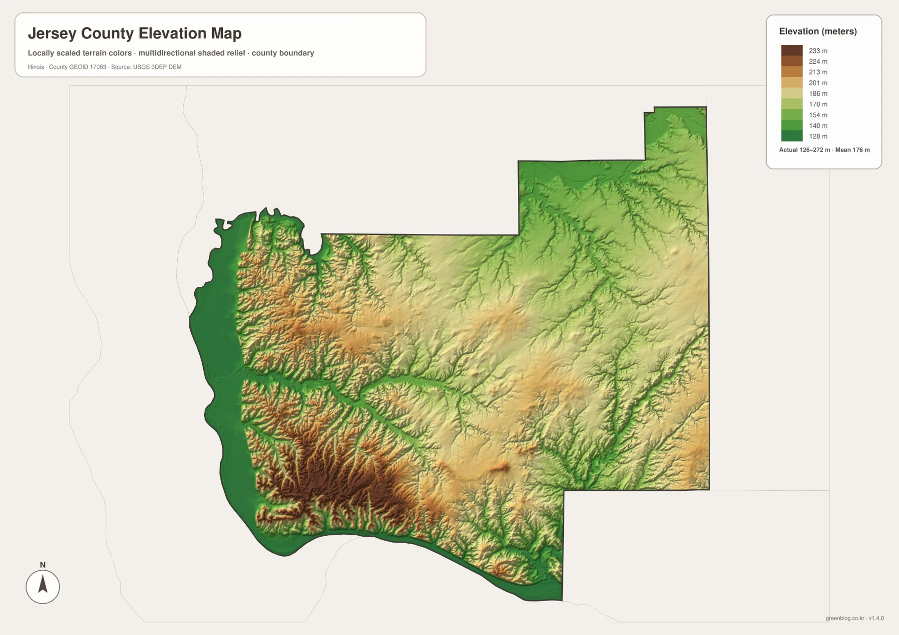
The elevation map gives the clearest visual explanation for Jersey County’s river bluffs and deeply cut southwest. Dark green marks the lowest land along the outer river margins, while orange and brown ridges rise abruptly just inland. The most rugged texture is concentrated in the southwestern quarter, where short valleys and narrow ridges crowd together north of the river. Moving toward the central and eastern portions, the colors become less extreme and the surface appears broader, even though numerous creek valleys still cut across it.
The legend reports an actual elevation range of roughly 126 to 272 meters and a mean of about 176 meters for the mapped surface. Because the color scale is adjusted to local relief, it is best used for comparison inside Jersey County rather than for judging elevation against distant counties. The shaded texture is equally important. Narrow green lines extending into higher ground usually correspond to valleys, and many can be matched with the creek network on the terrain-and-water map.
The southwestern relief also provides county-scale context for Pere Marquette State Park. Illinois DNR describes the park area in terms of wooded hills, bluffs, river views, and a landscape influenced by the great rivers. The county elevation map is not a park trail map, yet it shows the larger setting clearly: the river-edge lowlands sit directly below a heavily dissected high area. That contrast helps explain why the Grafton and Pere Marquette area can offer broad river views from elevated ground while still being close to low backwater terrain.
Farther north and east, the map does not become perfectly flat. Branching valleys remain visible, particularly where creeks have cut into the interior. The difference is one of degree: the southwest has sharper, denser ridges, while much of the center and east has longer, gentler slopes. This distinction can be lost on a road-only map, where both areas may simply look rural. Adding elevation makes the physical divide between the river-bluff country and the interior much easier to see.
The elevation image is generalized for regional viewing and should not be used as survey-grade or engineering-grade measurement. Anyone who needs exact heights, slopes, or site-level terrain should consult detailed U.S. Geological Survey 3D Elevation Program data or another authoritative source. For general county study, however, the map quickly answers the main visual question: where is the land low, where does it rise most sharply, and how do stream valleys break up the uplands?
Choose the map by the question you need to answer
If the goal is to locate a community and understand how to approach it from elsewhere in the county, start with the boundary-and-road map. It shows Jerseyville in relation to Route 16 and U.S. 67, places Grafton and Elsah on the southern corridor, and keeps enough surrounding geography visible to orient the county within western Illinois. The community map is better when road detail is a distraction and the main task is to compare the positions of the six labeled population centers.
For natural geography, the water and elevation maps work best as a pair. Follow Otter Creek, Piasa Creek, and the Macoupin Creek branches on the terrain-and-water map, then switch to the elevation image to see the low valleys and surrounding higher ground. The comparison is especially effective in the southwest, where low river margins sit beside steep ridges. It also helps in the east, where longer creek valleys cut through less dramatic uplands.
For printed work, a clean map often communicates more than an overloaded one. A local-history page about Jerseyville may need the road map and community map, while a lesson about rivers and landforms may be clearer with the water and elevation maps. The web previews are sized for convenient page viewing. When labels need to remain legible at a larger size, use the ZIP below to obtain the original JPG versions rather than enlarging the smaller preview images.
The maps also have clear limits. County boundaries are not parcel boundaries, road lines do not replace current turn-by-turn navigation, and the water map does not indicate flood insurance zones or boating conditions. The elevation surface is suitable for visual comparison, not site engineering. Keeping those limits in mind makes the collection more useful, because each file can be used for the county-scale question it was designed to answer.
Taken together, the maps show a county with a recognizable interior hub, dispersed small communities, several independent creek systems, and a pronounced river-bluff landscape in the southwest. Jerseyville is the strongest reference point for roads and settlement, but the Grafton-Elsah corridor is just as important for understanding the county’s physical geography. That combination of inland roads and river-edge relief is what makes Jersey County easy to distinguish from a generic rectangular county on a statewide map.
Frequently Asked Questions
Which map is best for comparing Jerseyville with Grafton and Elsah?
Use the boundary-and-road map when you want the route context as well as the place names. Jerseyville is near the center, while Grafton and Elsah are along the southern river corridor. If you only need a quick positional comparison, the ranked-community map is simpler because it emphasizes the six mapped communities and removes much of the other detail.
Does the water map show flood zones along the Mississippi River?
No. It shows rivers, creeks, selected lakes and backwaters, and shaded terrain for county-scale reference. It is not a FEMA flood map and should not be used to decide whether a property is inside a regulatory floodplain. Current flood-risk questions require the appropriate official flood-hazard source.
How precise is the Jersey County elevation map?
It is intended for regional visual comparison. The legend shows an approximate mapped range of 126 to 272 meters and a mean near 176 meters, which is useful for seeing the low river edge and higher southwestern ridges. It is not survey-grade data, so site-level elevation or engineering work should use authoritative detailed elevation datasets.
Map File Information
The ZIP contains the original high-resolution JPG versions of the Jersey County boundary-and-road map, community map, terrain-and-water map, and elevation map. These larger files are better suited to close viewing and print use than the web previews on this page.
- Included Files: 4 high-resolution JPG maps
- File Type: JPG images packaged in one ZIP archive
Related Maps
Sources and reference data
The following public sources provide county background or authoritative geographic data related to the features shown on the maps.
- Jersey County Government – county overview, Jerseyville, Grafton, and local government information
- Illinois State Archives – Jersey County – county establishment, seat, and administrative history
- Illinois Department of Natural Resources – Pere Marquette State Park – river-bluff landscape and park background
- U.S. Census Bureau TIGER/Line Shapefiles – county boundaries and related geographic framework
- USGS National Hydrography – authoritative hydrography data
- USGS 3D Elevation Program – elevation source data
Green Map creates custom-edited map images using open geographic data sources such as geoBoundaries, Natural Earth, OpenStreetMap, and government open data.
These maps are edited visual materials, not raw data files, and are provided for education, documents, presentations, and graphic reference.