Walton County Florida Map files on this page can be previewed in the article and downloaded as high-resolution A3 JPG images in one ZIP archive. The county is unusually long from north to south: Paxton sits near the Alabama line, DeFuniak Springs is the inland county seat, Freeport lies much farther south, and Choctawhatchee Bay separates the mainland interior from the Gulf communities of South Walton. U.S. 331 ties those pieces together and is the easiest road to follow when learning the county’s overall shape.
The county reference map shows towns, major roads, neighboring counties, and the bay in one view. The city-connection map uses Freeport as the hub and compares its position with DeFuniak Springs and Paxton, while the terrain-and-water map highlights Shoal River, Alaqua Creek, Bruce Creek, Choctawhatchee River, Choctawhatchee Bay, and many smaller waterways. The three views answer different questions, which is especially useful in Walton because the northern uplands, central road corridor, broad bay, and Gulf coast do not look like one continuous settlement zone.
Table of Contents
U.S. 331 gives Walton County its clearest north-south reference
Start at the top of the county with Paxton, close to the Alabama state line. U.S. 331 continues south toward DeFuniak Springs, then reaches Freeport before crossing toward South Walton. Because the county is tall and narrow in places, following that one road provides a useful mental line through three very different sections: the far north, the county-seat area, and the bay-side middle.
DeFuniak Springs is where the north-south route meets the county’s strongest east-west road network. U.S. 90 crosses the city, and I-10 passes nearby, so travelers approaching from Okaloosa County or Washington County can enter the county-seat area without following the same roads used on the coast. Other state routes appear on the map, but U.S. 331, U.S. 90, and I-10 provide the most useful framework for reading northern Walton.
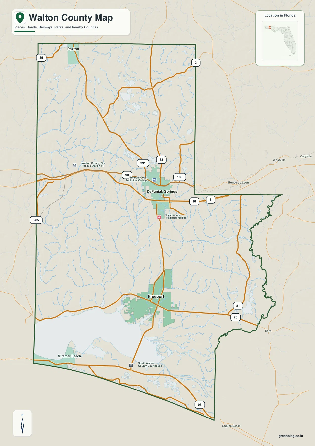
The county boundary changes shape as it moves south. Alabama is immediately north of Paxton, Okaloosa County forms the long western neighbor, and Holmes, Washington, and Bay counties lie to the east in different sections. The eastern line has a pronounced step and several irregular bends, while the lower county spreads across the bay and Gulf side. This makes Walton difficult to picture accurately from a single town name; the full county outline matters.
Freeport’s city map shows how stretched the three municipalities are
The city-connection map uses Freeport as its hub. It labels DeFuniak Springs at about 14 miles and Paxton at about 35 miles from Freeport. Those numbers are straight-line distances, not road-driving distances, so they should be used to compare relative separation rather than to predict mileage on U.S. 331 or another route.
Freeport is the southernmost of the three cities shown, DeFuniak Springs occupies the middle, and Paxton sits near the far northern edge. The ranking labels Freeport first, DeFuniak Springs second, and Paxton third, but the more useful insight is geographic: the incorporated cities are spread over a long north-south span rather than grouped in one urban cluster. Large areas of forest, streams, and lower-density land lie between them.
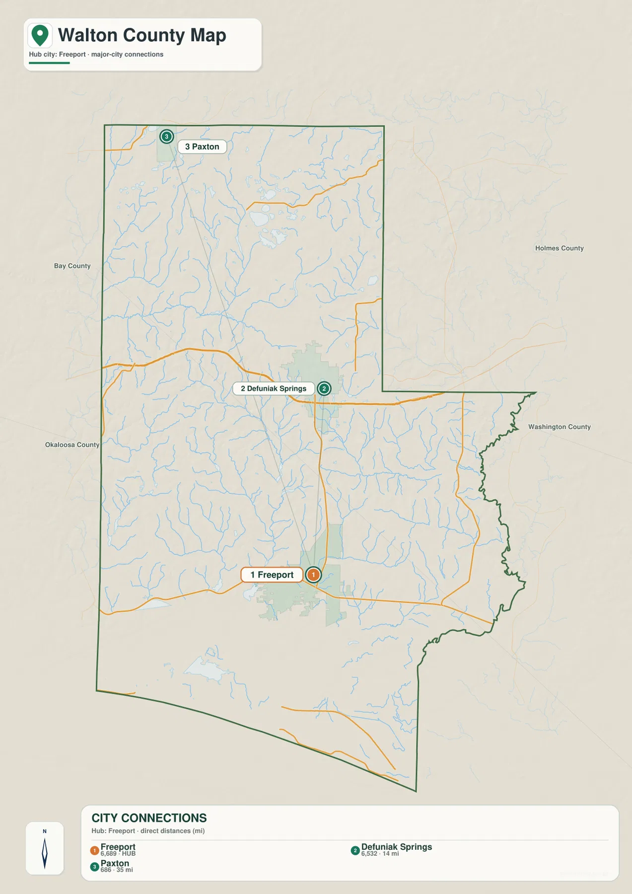
That spread helps explain why Walton County has more than one practical center. DeFuniak Springs is the county seat and inland service center, Freeport sits closer to Choctawhatchee Bay, and Paxton serves as the northern municipal reference near Alabama. South Walton adds a separate coastal concentration that is not represented by the three-city ranking alone.
Choctawhatchee Bay changes how north-south travel works
Choctawhatchee Bay occupies a broad east-west space in the lower half of the county. Freeport sits close to its northern side, while the South Walton communities and U.S. 98 corridor are south of the water. That arrangement means the coastal part of the county is not simply the next row of towns below Freeport. A major body of water separates the two, and crossings determine how the inland and Gulf sides connect.
U.S. 331 crosses the bay and continues toward U.S. 98, making it one of the most important through routes between DeFuniak Springs, Freeport, and the Gulf side. A straight-line look at the map can make north Walton and South Walton seem close, but the bay limits where vehicles can cross. The road network therefore makes more sense when the bridge and bay are treated as central geographic features rather than background water.
From Shoal River and Alaqua Creek to Choctawhatchee River and Bay
The terrain-and-water map reveals a much denser network than the road map. In the north, Long Creek runs toward Shoal River, while Gum Creek is labeled farther east. Alaqua Creek extends through the central interior, and Bruce Creek crosses the eastern side. These named features are only part of a much larger web of small blue tributaries spread across the county.
In southeastern Walton, Black Creek and Choctawhatchee River are labeled near the county edge. Closer to the bay, Sister River and many smaller channels enter the low coastal landscape. Inside Choctawhatchee Bay, the map also names Jolly Bay, Bunker Cove, and Grassy Cove. Those labels show that the lower watershed is not one simple shoreline; it contains coves, river mouths, wetlands, and narrow channels.
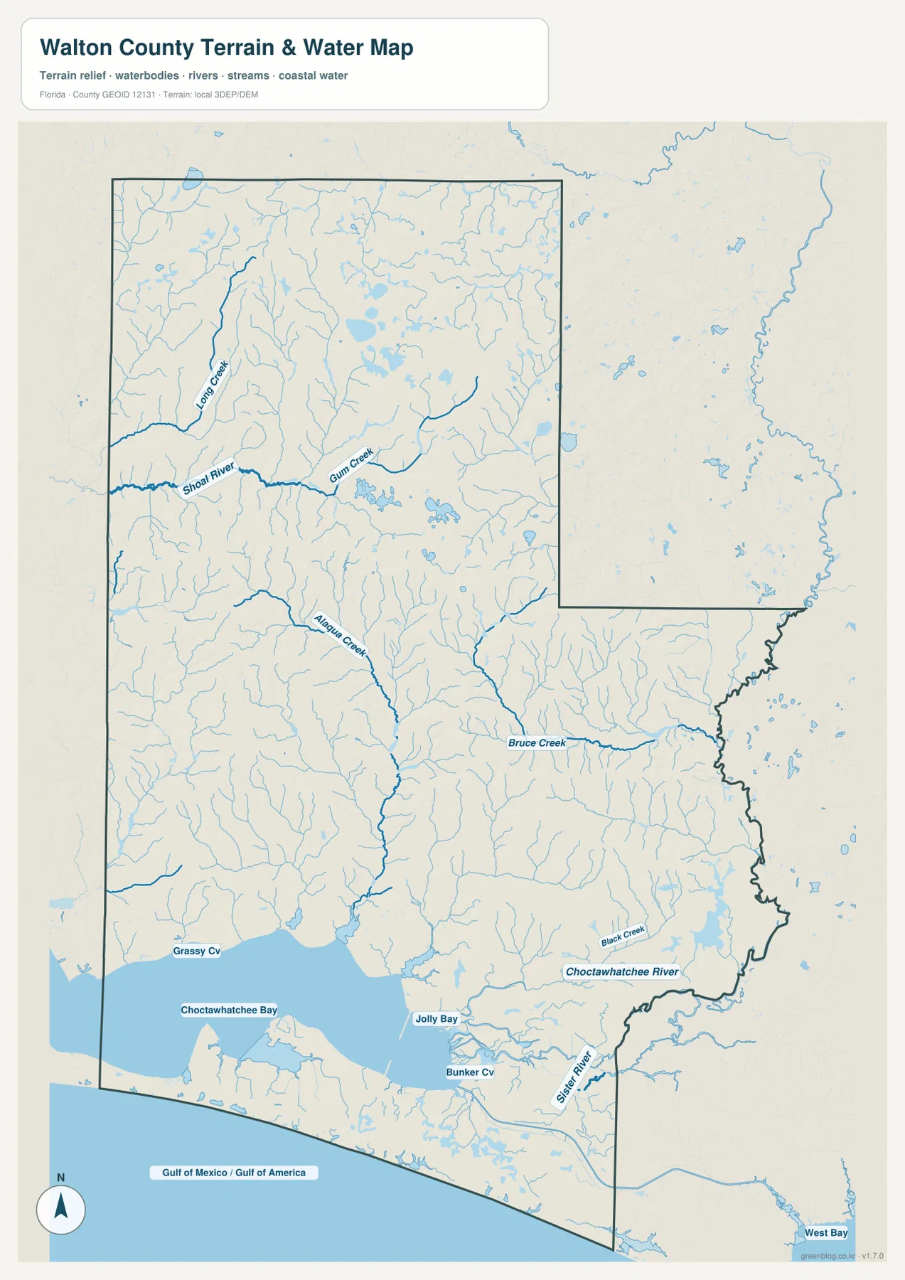
The shaded background provides broad terrain context, but it is not a survey-grade elevation surface. The blue waterways are also location references rather than a flood-risk map, nautical chart, parcel layer, or live river-stage product. For flooding, boating, engineering, or property work, use this map for orientation and then consult the current official source designed for that task.
South Walton follows a different road and landscape pattern
South of Choctawhatchee Bay, U.S. 98 becomes the main long-distance east-west road. On the county reference map, Miramar Beach appears near the western Gulf side, and existing Walton material identifies other South Walton communities including Santa Rosa Beach, Grayton Beach, Seaside, and Inlet Beach farther east. U.S. 98 connects the broader coastal region toward Destin on the west and Panama City Beach on the east.
County Road 30A runs closer to the Gulf through a number of beach communities and areas known for coastal dune lakes. Those lakes are a notable South Walton feature because they occur very near the Gulf shoreline, unlike the more familiar inland-lake setting. The supplied water map does not label every dune lake individually, so the page uses them as verified regional context rather than pretending every lake can be identified on this specific image.
This coastal side feels very different from the DeFuniak Springs area. Northern Walton is organized around I-10, U.S. 90, inland municipalities, and many small streams, while South Walton is organized around U.S. 98, local Gulf roads, beach communities, and the bay. U.S. 331 is the road that makes those two county experiences part of one connected map.
Choose the Walton map by what you need to locate
Use the county reference map when you need Paxton, DeFuniak Springs, Freeport, Miramar Beach, neighboring counties, or the major road network. Use the city-connection map when your question is how far apart the three displayed municipalities sit, remembering that its 14-mile and 35-mile labels are straight-line values. Choose the terrain-and-water map for Shoal River, Alaqua Creek, Bruce Creek, Choctawhatchee River, Choctawhatchee Bay, and the network of smaller tributaries.
For a classroom sequence, trace U.S. 331 south from Paxton to Freeport, compare the city distances, then switch to the water map to see why Choctawhatchee Bay creates such a strong divide between inland Walton and South Walton. The same sequence works for general trip orientation, but current bridge conditions, driving mileage, beach access, and water conditions should be checked separately.
Frequently Asked Questions
Are the 14-mile and 35-mile city distances driving distances?
No. The supplied city map labels DeFuniak Springs at about 14 miles and Paxton at about 35 miles from Freeport using straight-line distance. Actual road mileage will usually be longer and depends on the exact origin, destination, and route.
Why is U.S. 331 so important on a Walton County map?
It provides the clearest north-south link among Paxton, DeFuniak Springs, Freeport, and the South Walton side of Choctawhatchee Bay. Because the bay limits crossing locations, U.S. 331 also has special importance for reaching U.S. 98 and the Gulf side from the interior.
Is Freeport the county seat?
No. DeFuniak Springs is the Walton County seat. Freeport is farther south near Choctawhatchee Bay and is an important middle reference between the inland county seat and South Walton.
Can the terrain-and-water map be used for flood risk or boat navigation?
No. It is a location reference for rivers, creeks, bays, and terrain context. Flood zones, live water levels, depths, navigation hazards, and parcel boundaries require current specialized official data.
Map File Information
Download the Walton County reference map, city-connection map, and terrain-and-water map as high-resolution A3 JPG files.
- Included Files: County map JPG, city map JPG, terrain-and-water map JPG
- File Type: Three JPG files in one ZIP archive
Related Maps
- A Sumter County Florida Map
- Arcadia Roads and Peace River | DeSoto County Florida Map
- Baker County Florida Map
Sources and References
These public sources provide additional context for Walton County government, roads, coastal access, population, and the Choctawhatchee River and Bay watershed.
- Walton County official website
- U.S. Census Bureau – Walton County QuickFacts
- Florida DOT county general highway maps
- Florida DEP – Walton County coastal guide
- Choctawhatchee River and Bay watershed
- South Walton regional facts
Green Map creates custom-edited map images using open geographic data sources such as geoBoundaries, Natural Earth, OpenStreetMap, and government open data.
These maps are edited visual materials, not raw data files, and are provided for education, documents, presentations, and graphic reference.