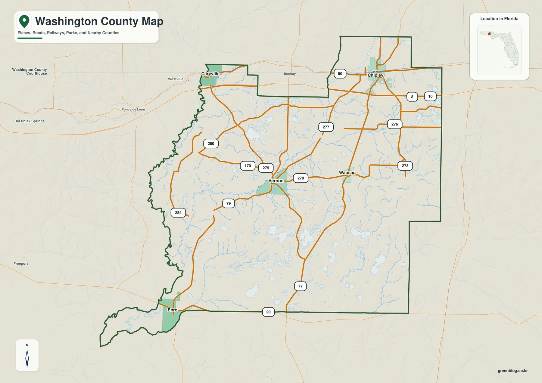
Washington County Florida Map files on this page can be previewed in the article and downloaded as high-resolution A3 JPG images in one ZIP archive. The county is easiest to understand by starting in the north at Chipley and Caryville, then following separate road systems toward Vernon, Wausau, and Ebro. I-10 and U.S. 90 create the northern east-west corridor, while SR 77 and SR 79 form different north-south routes through the interior. The western and southern portions become increasingly defined by rivers, creeks, springs, wetlands, and small lakes.
The county reference map combines communities, major roads, county lines, and the broad settlement pattern. A second map ranks Chipley, Vernon, Wausau, Caryville, and Ebro so their distribution is easier to compare without every road label. The terrain-and-water map shifts attention to Holmes Creek, Cypress Creek, Hard Labor Creek, Pine Log Creek, and many smaller blue channels. Together the maps show why northern transportation, central creek country, and the wetter southern interior should be treated as different parts of Washington County.
Table of Contents
Chipley is the clearest starting point for I-10 and U.S. 90
Chipley is the county seat and the strongest road reference in northern Washington County. I-10 crosses the northern part of the county for longer east-west travel, while U.S. 90 runs through the local settlement corridor and connects more directly with Chipley and Caryville. SR 77 passes through Chipley from north to south, giving the city a useful role in both regional and internal navigation.
Caryville lies west of Chipley near the same I-10/U.S. 90 corridor and close to the wetter western side of the county. Westville and Bonifay appear beyond the county boundary to the west and northwest, while Jackson County lies to the east. These surrounding labels make it easier to place Washington County within the Florida Panhandle rather than reading Chipley as an isolated inland town.
Falling Waters State Park south of Chipley provides useful physical-geography context. Existing park material describes a small stream dropping about 73 feet into a deep cylindrical sinkhole. That feature helps explain why Washington County can contain surface streams, springs, and sinkholes in the same broader landscape: water moves through sandy soils and limestone-related drainage systems as well as visible creek channels.
Vernon separates the SR 79 corridor from the Chipley route
Vernon is the key map reference in the central part of the county. SR 79 approaches from the Bonifay direction, passes through Vernon, and continues south toward Ebro. SR 277 serves a different purpose by connecting the Vernon area with the U.S. 90 side west of Chipley. Treating those routes as separate functions makes the interior road network much easier to follow.
Wausau lies east of Vernon and is more naturally associated with the SR 77 side of the county. That creates two different north-south patterns: Chipley–Wausau on the SR 77 side and Vernon–Ebro on the SR 79 side. The two systems are connected, but they do not lead through the same communities or toward exactly the same southern destinations.
The ranked city map spreads five places across the county
The city-ranking map lists Chipley first, Vernon second, Wausau third, Caryville fourth, and Ebro fifth. Its value is not that it contains every community in Washington County; instead, it provides a simplified pattern of where the five displayed places sit. Chipley and Caryville occupy the north, Vernon and Wausau sit closer to the middle, and Ebro is far to the southwest.
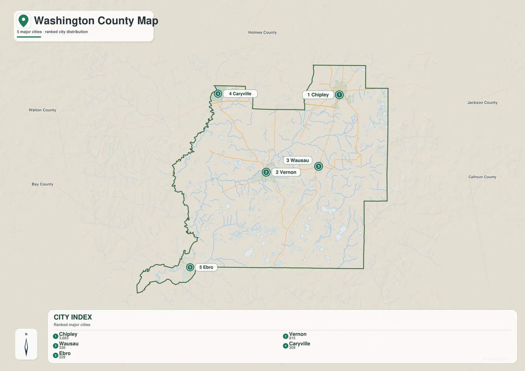
Comparing that simplified view with the road map reveals why the places developed along different movement corridors. Chipley is tied to I-10, U.S. 90, and SR 77; Vernon to SR 79 and SR 277; Ebro to SR 79 and SR 20. Wausau occupies the central-eastern side of the county rather than the same axis as Vernon. The settlement pattern therefore makes more sense when road orientation is added back to the city ranking.
Holmes Creek anchors the central water network
The terrain-and-water map is dominated in the middle by Holmes Creek and a dense set of tributaries. Cypress Creek, Gum Creek, Flat Creek, and Hard Labor Creek are among the named channels visible on the map. When this water view is compared with Vernon’s position on the county map, the central part of Washington County becomes easier to understand as creek-and-spring country rather than simply a gap between Chipley and the southern communities.
Existing water-management material identifies Holmes Creek as a tributary of the Choctawhatchee River and notes the importance of springs along the system. The source material supplied with this package states that an official survey recorded 57 springs. That background fits the map’s dense tributary pattern and helps explain why creek access and low-lying land are important geographic features around the central-western part of the county.
Ebro marks the transition into the wetter southern interior
Ebro sits near the junction of SR 79 and SR 20, well south of the northern Chipley corridor. On the terrain-and-water map, Pine Log Creek is a prominent named feature in the southwest, and numerous small lakes and wet areas appear across the southern half of the county. The pattern becomes more water-dominated as the map approaches the Bay County side.
Existing Washington County material also identifies Econfina Creek as an important southern water system that continues toward Bay County and is strongly influenced by springs and groundwater. The supplied water map labels Econfina River near the southeastern edge. Used together with the existing Econfina Creek management-area source, those materials show that southern Washington County has a separate drainage setting from the Holmes Creek system farther north.
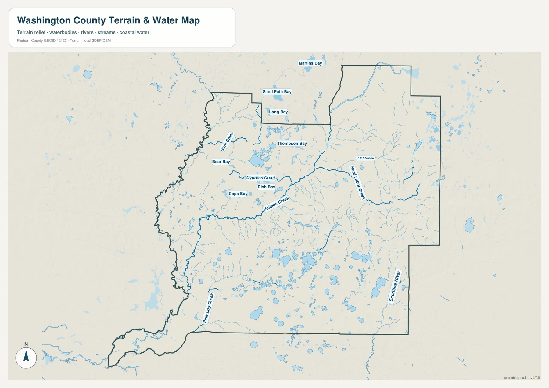
The shaded background provides broad terrain context rather than survey-grade elevation. Likewise, the mapped creeks and lakes are location references, not a flood map, navigation chart, parcel layer, or live water-level product. For flooding, boating, engineering, or property decisions, use this map for orientation and then consult the current official source designed for that task.
The Choctawhatchee side explains the irregular western boundary
The western side of Washington County is less geometric than the eastern side because river and floodplain geography influences much of the boundary. Existing county material describes the Choctawhatchee River along the broad western floodplain and places the Caryville area close to the I-10/U.S. 90 crossing corridor. Road crossings therefore matter: a river can make two points appear close while still limiting where vehicles can actually move between sides.
Farther south, wetlands and smaller channels make the western and southwestern boundary even more irregular. Comparing the county outline with the terrain-and-water map shows why some boundary segments bend sharply rather than following a simple north-south line. In this part of the county, administrative geography and physical geography often overlap.
Choose the map by whether roads, cities, or water matter most
Use the county reference map for Chipley, neighboring counties, I-10, U.S. 90, SR 77, SR 79, and the overall settlement pattern. The ranked city map is cleaner when your question is where Chipley, Vernon, Wausau, Caryville, and Ebro sit relative to one another. Choose the terrain-and-water map for Holmes Creek and its tributaries, Pine Log Creek, small lakes, and the wetter southern landscape.
For a classroom or presentation sequence, begin with Chipley and the northern highway corridor, compare the ranked cities, then switch to the water map to explain Holmes Creek and the southern drainage systems. The same sequence works for general trip orientation, but current road conditions, unpaved-road access, bridge restrictions, and water levels should be checked separately.
Frequently Asked Questions
What is the Washington County seat?
Chipley is the county seat. It is in northern Washington County near I-10 and U.S. 90, with SR 77 running north-south through the city, making it the most useful starting point for reading the county road map.
Do SR 77 and SR 79 follow the same southern corridor?
No. SR 77 is the better reference for the Chipley-Wausau side, while SR 79 is the main north-south route through Vernon and Ebro. They connect parts of the same county but organize different community patterns.
Are Holmes Creek and Econfina Creek the same water system?
No. Holmes Creek is described in the supplied source material as a tributary of the Choctawhatchee River in the central-western part of the county, while Econfina Creek belongs to a separate southern drainage setting that continues toward Bay County.
Can the terrain-and-water map be used as a flood-risk map?
No. It shows the locations of waterways and terrain context, but it does not provide flood zones or live water levels. Flood-risk decisions require current FEMA or local official data.
Map File Information
Download the Washington County reference map, ranked city map, and terrain-and-water map as high-resolution A3 JPG files.
- Included Files: County map JPG, city map JPG, terrain-and-water map JPG
- File Type: Three JPG files in one ZIP archive
Related Maps
- A Sumter County Florida Map
- Arcadia Roads and Peace River | DeSoto County Florida Map
- Baker County Florida Map
Sources and References
These public sources provide additional context for Washington County communities, roads, waterways, and physical geography.
- U.S. Census Bureau – Washington County QuickFacts
- Washington County Planning Department and municipalities
- Washington County Public Works road and bridge information
- Florida DOT county general highway maps
- Choctawhatchee River and Holmes Creek Water Management Area
- Econfina Creek Water Management Area
- Falling Waters State Park geography
Green Map creates custom-edited map images using open geographic data sources such as geoBoundaries, Natural Earth, OpenStreetMap, and government open data.
These maps are edited visual materials, not raw data files, and are provided for education, documents, presentations, and graphic reference.