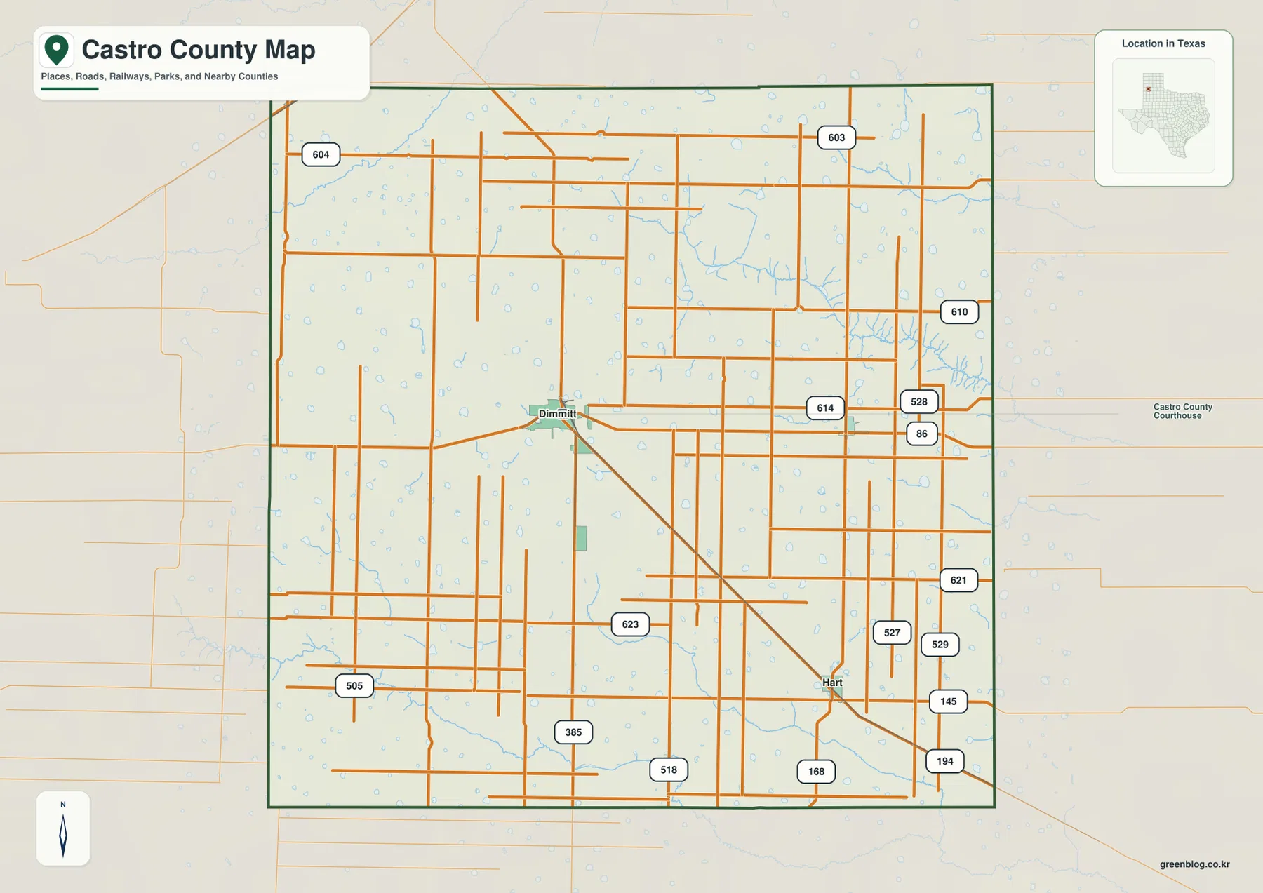
Castro County occupies a broad section of the Texas High Plains, where Dimmitt, Hart, and Nazareth are separated by large areas of open agricultural land. The county map makes the transportation pattern look simple at first: US 385 passes through Dimmitt, State Highway 86 crosses the county from west to east, and many rural roads follow long straight lines. The water and elevation maps add the details that the road grid hides. North Tule Draw and Middle Tule Draw cut through the northeast, Running Water Draw follows the southern side, and numerous small playa depressions are scattered across the plain. Four matching high-resolution JPG files—the county, city, water, and elevation maps—are available together in the ZIP download on this page.
Dimmitt is the easiest place to use as an anchor. From the hub, Nazareth lies to the east-northeast and Hart to the southeast. The supplied city-connections map gives straight-line distances of about 12 miles from Dimmitt to Nazareth and 16 miles from Dimmitt to Hart. Those figures are not driving distances, but they make the spacing of the three communities easy to compare. The elevation surface adds a second countywide pattern: higher terrain is strongest in the west and northwest, while the east and southeast are generally lower, with sharply cut draw valleys visible inside that broader slope.
Table of Contents
Dimmitt at the Meeting of US 385 and State Highway 86
The general county map places Dimmitt slightly west of center. US 385 runs through the city and continues south toward the county line, while State Highway 86 approaches from the west and crosses eastward through the Dimmitt area. The concentration of streets around that intersection makes the city the clearest orientation point on the map. Hart appears farther southeast, linked to the Dimmitt area by a diagonal route that stands out from the otherwise strong north-south and east-west road grid.
Away from the towns, the transportation network becomes remarkably regular. Long rural roads divide the agricultural landscape into large rectangular blocks. The eastern side contains clusters of numbered routes such as 528, 527, 529, and 621, while routes 603 and 604 appear toward the north and 505 toward the southwest. These smaller numbers are not necessary for basic orientation, but they show how farm access and local circulation fill the spaces between the major highways.
The straight road pattern reflects the broad, gently sloping surface of the Llano Estacado, the high-plains region that includes Castro County. Unlike mountain counties, roads here rarely need to wind around major ridges. Yet the land is not perfectly flat. Draws and shallow depressions interrupt the surface in several places, and those features become much more obvious on the water and elevation maps than on the county road map.
Dimmitt, Hart, and Nazareth Form a Widely Spaced Three-Community Pattern
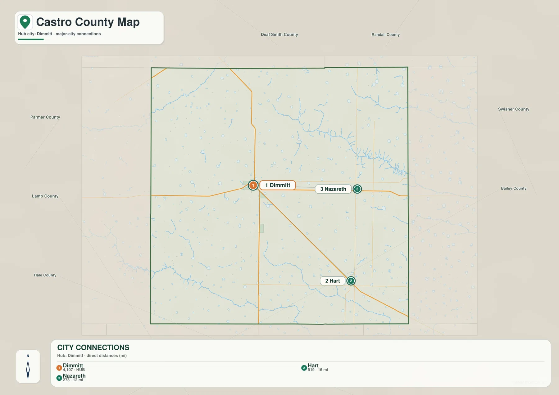
The city-connections map strips away most of the minor road detail and focuses on Dimmitt, Hart, and Nazareth. Its index lists Dimmitt at 4,107, Hart at 919, and Nazareth at 273. Dimmitt is therefore the largest of the three mapped communities and serves as the hub. Nazareth is positioned to the east-northeast, while Hart is farther southeast, producing a loose triangular arrangement across the county rather than a continuous line of development.
The connection labels show approximately 12 miles from Dimmitt to Nazareth and 16 miles from Dimmitt to Hart. These are direct point-to-point distances, not road mileage. Actual trips may be longer depending on the route used and the specific starting location within each community. Even so, the values are useful for understanding how much agricultural land separates the towns and why the county’s settlement pattern feels open rather than urbanized.
Neighboring county labels help place Castro County within the Panhandle grid. Deaf Smith and Randall counties are shown along the northern side of the broader view, Swisher County lies to the east, and Hale, Lamb, and Bailey counties appear around the southern and southeastern sides. Parmer County is to the west. Because Dimmitt, Hart, and Nazareth occupy different parts of the county, each community has a different relationship to those surrounding counties even though they are all within the same administrative boundary.
The simplified city map is useful precisely because it does not try to answer every transportation question. It shows rank, spacing, and direction. The county map can then be used to see which highways and farm roads make those connections in practice. Keeping the two roles separate avoids confusing straight-line distance with road travel and makes the county’s settlement geography easier to explain.
Tule Draws in the Northeast and Running Water Draw Along the South
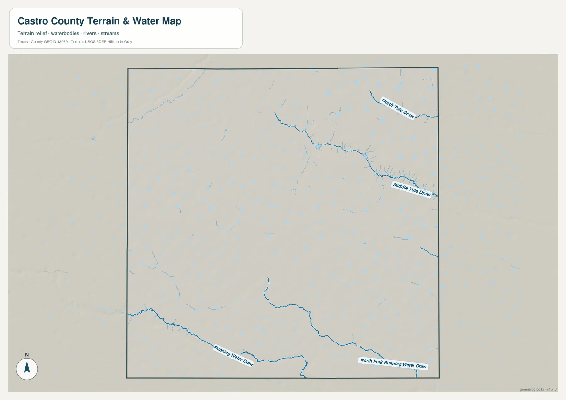
The terrain-and-water map reveals the county’s drainage far more clearly than the road map. North Tule Draw is labeled in the northeastern corner, and Middle Tule Draw follows a lower channel farther south before reaching the eastern boundary. Branching tributaries feed these draws from the interior, producing a network of shallow valleys that cuts across what otherwise appears to be a nearly level High Plains surface.
The southern side has a different drainage reference. Running Water Draw enters from the west and follows a long course near the bottom of the county. Farther east, North Fork Running Water Draw is labeled close to the southern boundary. Another substantial channel descends through the south-central area toward the same general drainage zone. These blue lines explain why the southern edge is not simply an uninterrupted flat plain even though the road network remains strongly rectilinear.
Hundreds of small pale-blue spots and oval shapes are scattered across the map. On the High Plains, many shallow closed depressions are playas, which may hold visible water after precipitation and become much drier at other times. The map is therefore best read as evidence of widespread small depressions and water-collecting areas, not as proof that every blue spot is a permanently full lake. Their density is one of the most distinctive features of the supplied Castro County water map.
The water map is intended for general geographic reference. It is not a flood-hazard product, parcel map, water-rights record, depth chart, or current water-level map. Those questions require the appropriate official datasets. For ordinary map reading, North Tule Draw, Middle Tule Draw, Running Water Draw, and the widespread playa depressions provide enough landmarks to understand how drainage interrupts the otherwise broad plain.
Elevation from About 1,081 to 1,220 Meters Across the High Plains
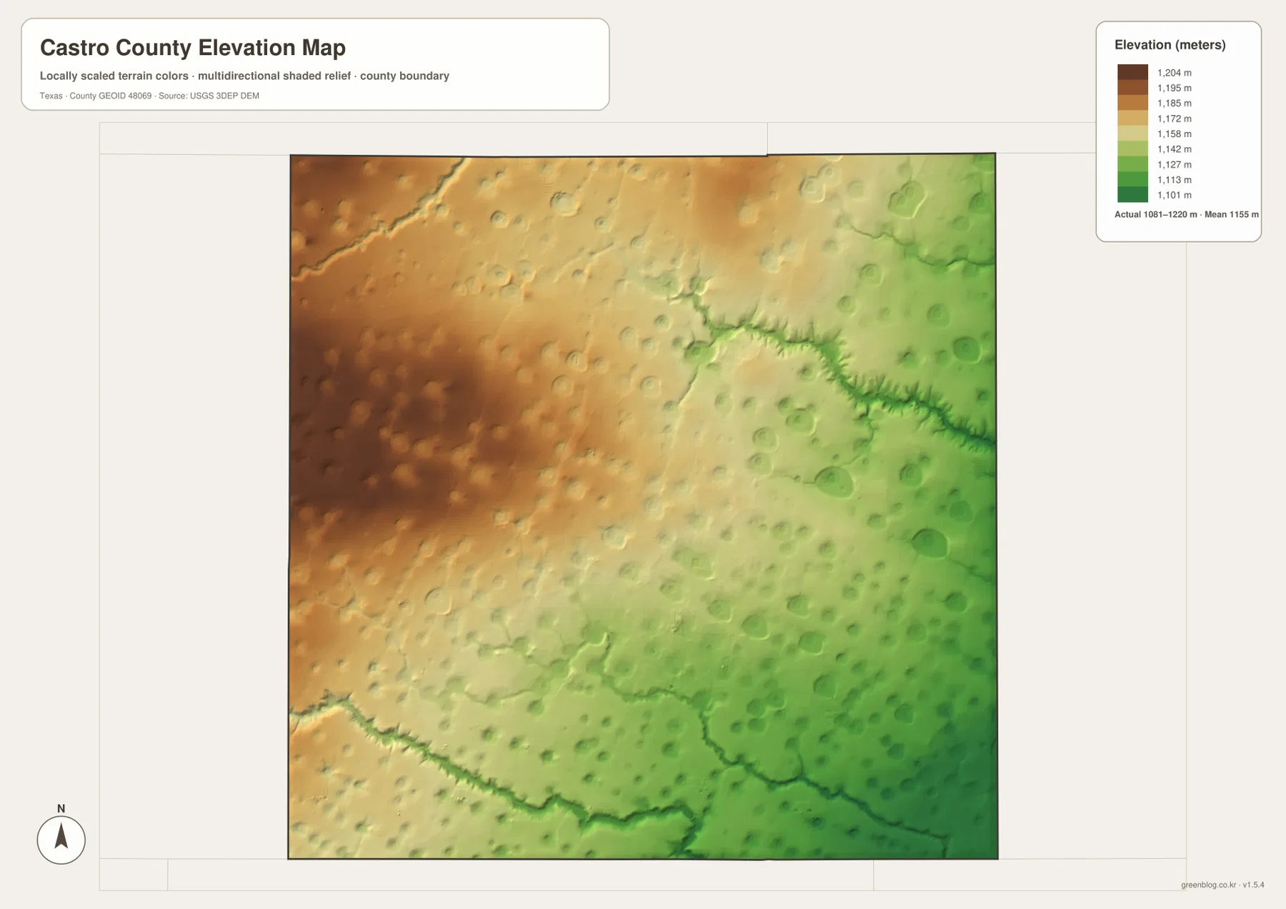
The supplied elevation map reports an actual range of about 1,081 to 1,220 meters and a mean near 1,155 meters. Castro County is therefore high throughout, but there is still a clear internal gradient. Brown and orange terrain dominates much of the west and northwest, while yellow-green and green areas become more extensive toward the east and southeast. The change is broad and gradual across much of the county, consistent with the appearance of a gently sloping high plain.
The northeast breaks that smooth pattern. The Tule Draw channels appear as sharply incised green lines cut into the surrounding surface. When North Tule Draw and Middle Tule Draw are located on the water map and then matched to the elevation map, their valleys line up with the most obvious narrow low corridors. This makes the relationship between drainage and relief especially easy to see in that part of the county.
Running Water Draw creates another low corridor near the southern edge. Its course can be followed across the elevation colors, and the south-central drainage joins an area of lower relief near the bottom of the map. Rounded playa depressions are also visible across both high and low portions of the surface. Because the overall slopes are gentle, these small depressions and narrow draws create much of the local topographic texture.
The elevation map is suitable for county-scale comparison, not survey or engineering measurement. It should not be used to determine the precise elevation of a field corner, road grade, well site, or building pad. The 1,081–1,220 meter range and 1,155 meter mean are best treated as broad reference values that show Castro County’s high elevation and the relative decline from the west toward lower draw country in the east and south.
Why the Straight Road Grid and the Playa-Dotted Terrain Look So Different
The county road map emphasizes order. Long straight lines divide large blocks of rural land, and Dimmitt forms an obvious crossroad at US 385 and State Highway 86. The physical maps reveal a less uniform surface underneath that grid. Numerous small depressions interrupt the fields, while long draw valleys cut across the northeast and southern edge. The contrast is useful because it shows that a regular transportation pattern does not mean the underlying land is perfectly level or hydrologically simple.
The northeast provides the strongest example. Nazareth is positioned near the eastern half of the county, not far from the area where Tule Draw branches become increasingly visible. Elevation is lower there than across much of the west. Hart, in the southeast, is closer to the broader low area associated with Running Water Draw and the southern drainage network. Dimmitt occupies a more central transition between the higher west and lower east, making it a useful point for comparing all four supplied maps.
Castro County’s irrigated agriculture and long association with the Ogallala Aquifer are part of the county background described in the existing source article, but the supplied maps do not show groundwater depth, pumping rates, or crop production. Those subjects require separate groundwater and agricultural data. Here, the visible evidence is more limited and more direct: towns, roads, surface drainage, playa depressions, and countywide relief.
Choosing a Castro County File for Printing or Detailed Comparison
The general county map is the most useful single image for basic orientation because Dimmitt, Hart, US 385, State Highway 86, minor rural roads, and the county boundary appear together. The city-connections map is cleaner when the goal is to compare Dimmitt, Hart, and Nazareth or explain the 12- and 16-mile straight-line distances. The water map is the best choice for the Tule and Running Water draws and the widespread playa depressions, while the elevation map most clearly shows the higher western plain and lower eastern drainage corridors.
Small route numbers, narrow draw branches, and individual playa symbols may be difficult to read in a reduced browser preview. The original JPG files are better for enlargement and printing, and they are also convenient when Castro County is being compared side by side with other Panhandle counties. Keeping the same map type at a similar scale makes differences in roads, settlement spacing, drainage, and relief much easier to judge.
The ZIP below contains four high-resolution A3 JPG files corresponding to the county, city, water, and elevation maps shown in the article. They can be enlarged for detailed label reading, printed for classroom or personal reference, or placed alongside neighboring county maps for regional comparison.
Frequently Asked Questions
Are the Dimmitt-to-Hart and Dimmitt-to-Nazareth distances driving distances?
No. The supplied city-connections map shows straight-line distances of about 12 miles from Dimmitt to Nazareth and 16 miles from Dimmitt to Hart. Driving distances depend on the roads used and the exact starting and ending points.
Are all of the small blue playa features permanent lakes?
Not necessarily. High Plains playas are shallow depressions that can hold water after precipitation and may become much drier at other times. The map is useful for showing how widespread those depressions are, but it should not be treated as a current water-level map.
Which part of Castro County is highest on the supplied elevation map?
The west and northwest contain much of the higher terrain, while elevations generally decrease toward the east and southeast. The map reports a countywide range of about 1,081–1,220 meters and a mean near 1,155 meters, with notably low corridors along the Tule and Running Water draws.
Sources and Reference Data
- U.S. Census Bureau TIGER/Line Shapefiles — official geographic boundary, road, and place data.
- USGS National Hydrography — official information about streams, draws, lakes, and hydrography data.
- USGS 3D Elevation Program — official elevation and terrain data information.
- USGS The National Map Viewer — interactive access to boundaries, transportation, hydrography, terrain, and other geographic layers.
Map File Information
Download the Castro County county, city, water, and elevation maps together as high-resolution A3 JPG files.
- Included Files: 4 maps
- File Type: JPG
Related Maps
- Parmer County Texas map
- Randall County Texas map
- Swisher County Texas map
- Oldham County Texas map
- Potter County Texas map
Green Map creates custom-edited map images using open geographic data sources such as geoBoundaries, Natural Earth, OpenStreetMap, and government open data.
These maps are edited visual materials, not raw data files, and are provided for education, documents, presentations, and graphic reference.