Chambers County in Southeast Texas wraps around a large part of Trinity Bay, so its geography is shaped as much by water as by roads. The northwest contains the most concentrated settlement and highway network around Mont Belvieu and Old River-Winfree, while Anahuac sits beside the bay farther east. Beach City and Cove follow the western shoreline, and the broad eastern half is crossed by bayous, canals, wetlands, and long rural roads. The supplied elevation map reports an actual countywide range of about -3 to 39 meters with a mean near 4 meters, making this one of the very low coastal landscapes in the map series. The county, city, water, and elevation maps shown here are also available together as four high-resolution JPG files in a ZIP download.
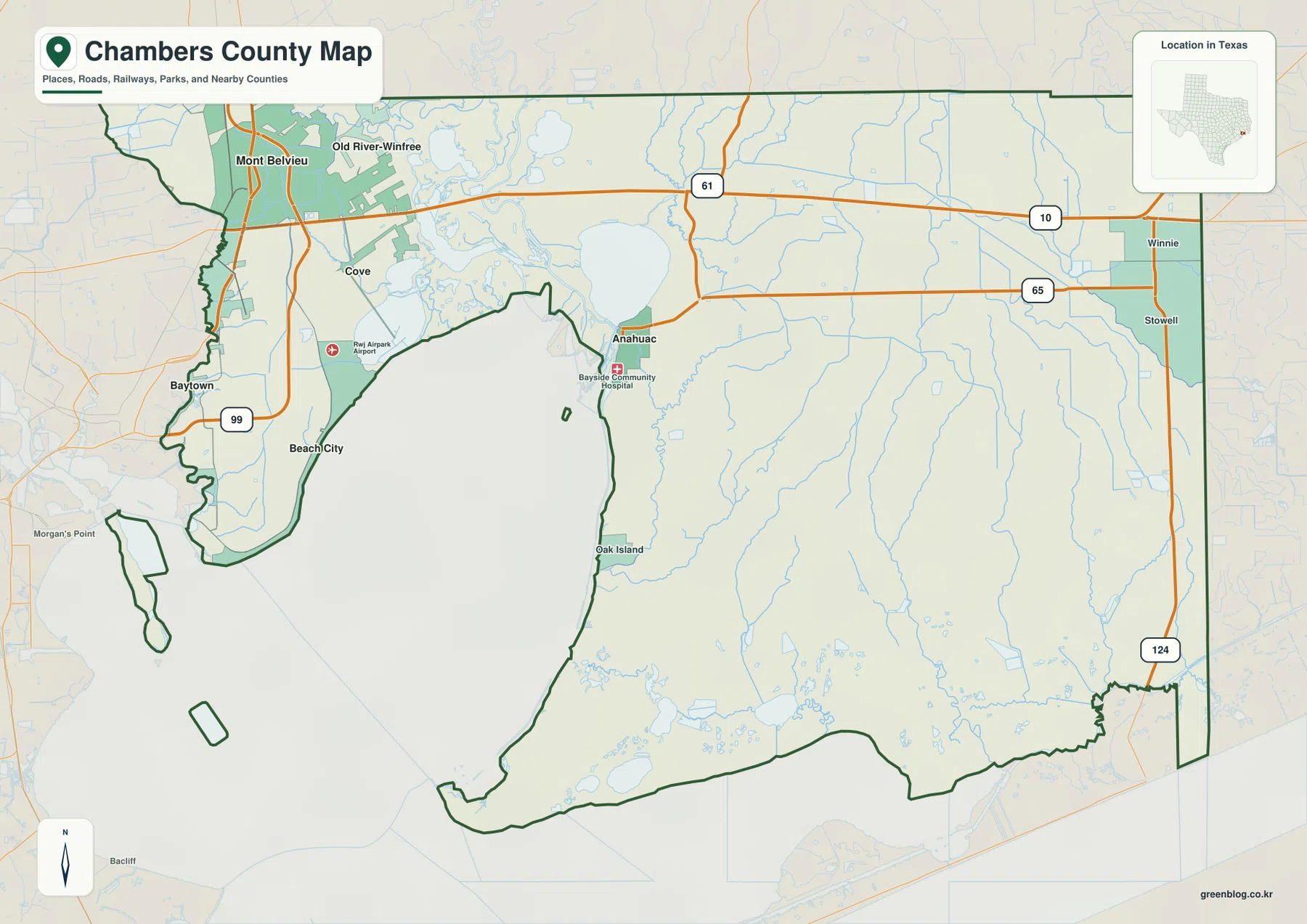
A useful way to orient the county is to locate Mont Belvieu in the northwest and Anahuac near the northeastern side of Trinity Bay. Interstate 10 passes close to Mont Belvieu and continues across the northern part of the county, while State Highway 61 turns south toward Anahuac. Farther east, Highway 65 reaches the Winnie area and Highway 124 runs toward the coast. Between those routes, the Trinity River estuary, Double Bayou system, marshy lowlands, and coastal water make the map much less regular than a simple rectangular county boundary would suggest.
Table of Contents
From the Mont Belvieu Highway Cluster to Anahuac on the Bay
The densest transportation pattern on the county map appears around Mont Belvieu. Interstate 10 crosses the area from west to east, State Highway 99 runs nearby, and Old River-Winfree is immediately to the north. Moving south from that cluster brings Cove and Beach City into view along the western side of Trinity Bay. Baytown appears just beyond the county, which helps explain why the northwest edge of Chambers County feels more closely tied to a large metropolitan road network than the broad rural area farther east.
Anahuac has a different setting. State Highway 61 leaves Interstate 10 and runs south toward the town, where Bayside Community Hospital is marked close to the built-up area. Trinity Bay begins immediately to the west, while the complicated Trinity River estuary lies to the north and northwest. Instead of a dense interchange landscape, Anahuac is surrounded by open water, wetlands, and narrow drainage channels that strongly influence the shape of nearby roads.
Across the eastern side, Interstate 10 and Highway 65 provide the clearest long-distance references. Winnie is near the eastern edge and Stowell lies farther south. Highway 124 continues toward the coastal part of the county, where settlements are sparse and waterways become more important than streets for orientation. A single road pattern therefore does not describe Chambers County well: the northwest, Anahuac area, eastern plain, and southern coast each have visibly different map features.
Five Ranked Communities Spread Around the Western Bay and Northwest Corner
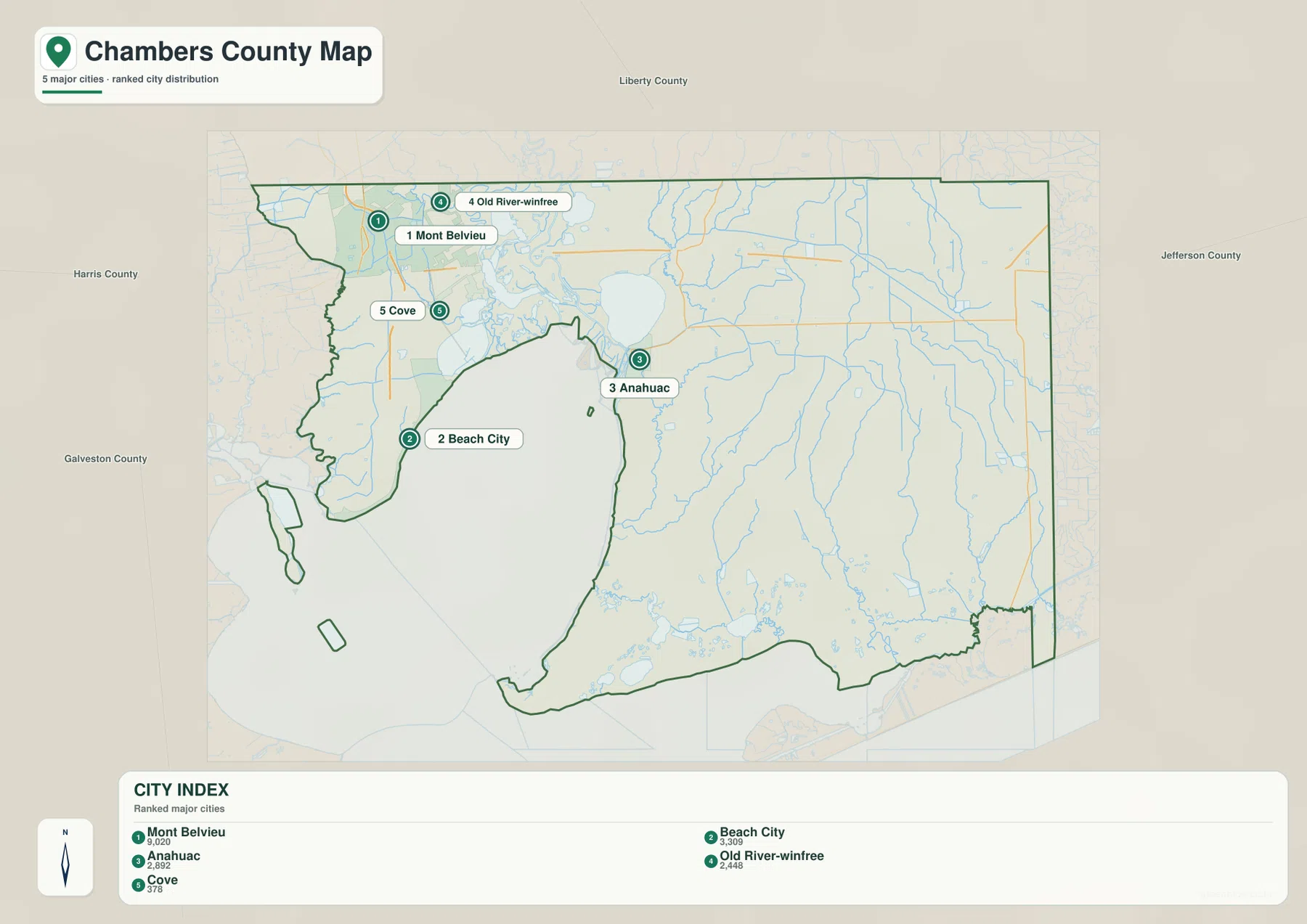
The ranked city map lists five major communities: Mont Belvieu at 9,020, Beach City at 3,309, Anahuac at 2,892, Old River-Winfree at 2,448, and Cove at 378. Mont Belvieu is the largest value shown in the supplied index, but the map is more useful for the way it separates these places geographically. Mont Belvieu and Old River-Winfree form a close northwest pair, while Beach City and Cove step southward along the western side of Trinity Bay.
Anahuac is well east of that group and occupies a different side of the bay. The open water and estuary between the western communities and Anahuac mean that apparent closeness on a small map does not translate into a direct road connection. Looking at the city map beside the county road map makes this especially clear: water creates a major gap in the settlement pattern even though all five communities belong to the same county.
The surrounding county labels provide additional orientation. Harris and Galveston counties are to the west, Liberty County is north of Chambers County, and Jefferson County is to the east. Mont Belvieu and Beach City sit close to the western edge, while Anahuac is better understood in relation to Trinity Bay and the central water landscape. The city map therefore shows not just rank but also the sharp geographic separation between the county’s northwest and bay-side communities.
Trinity River, Trinity Bay, East Bay, and the Bayou Network
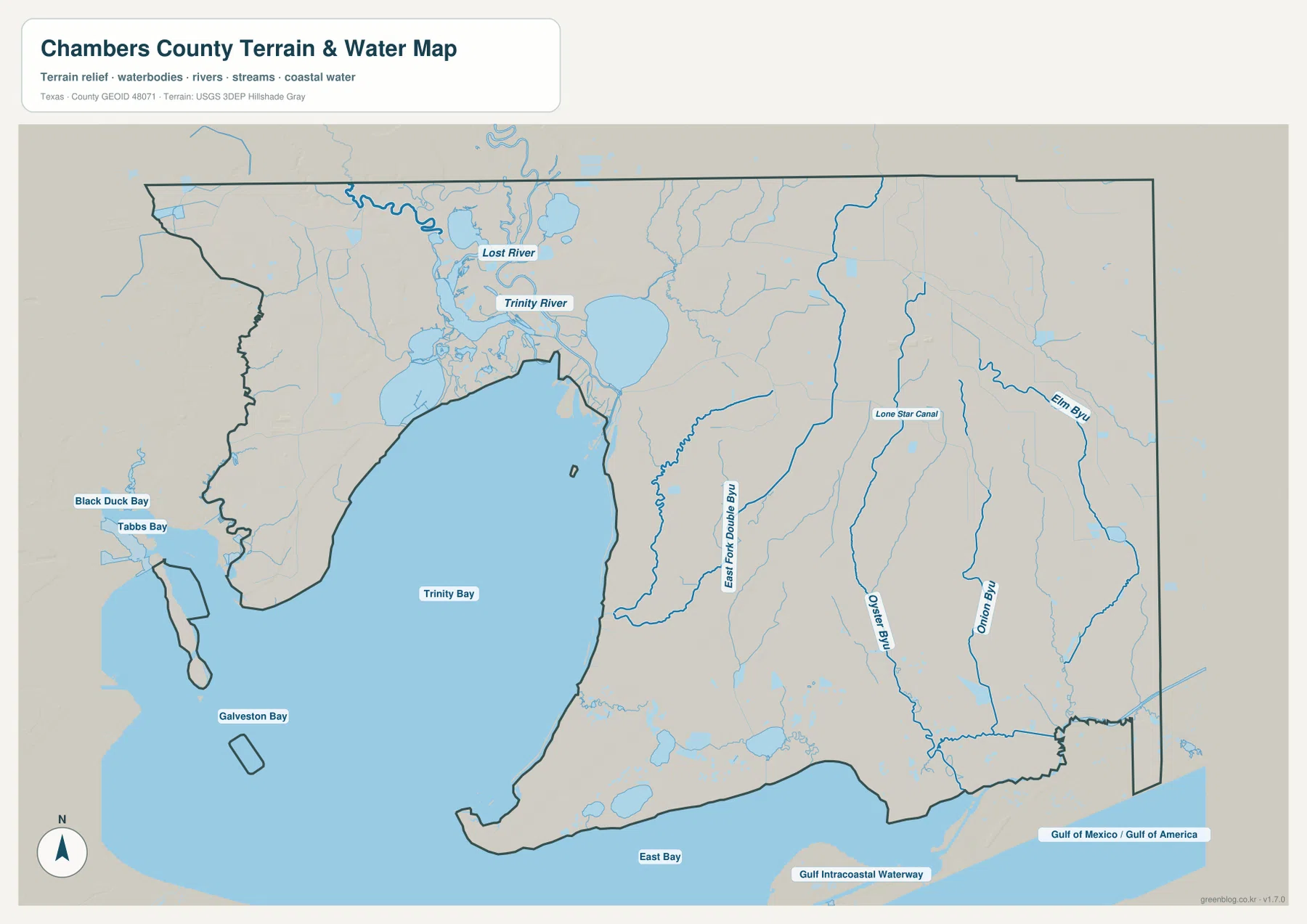
Trinity Bay dominates the terrain-and-water map. The bay extends deeply into the western and central part of Chambers County, separating the Beach City and Cove shoreline from Anahuac and the eastern mainland. Galveston Bay is labeled to the southwest and East Bay along the southern side. Near the coast, the Gulf Intracoastal Waterway forms another long, easily recognized line. These features make Chambers County a coastal water county in a way that is impossible to appreciate from road labels alone.
North of the bay, the Trinity River approaches through a complicated estuary. Lost River is labeled nearby, and the lower river breaks into a maze of water and wetland before reaching the bay. This helps explain why the area between the northwest communities and Anahuac is so irregular on the general county map. Much of the apparent empty space is not simply undeveloped land; it is a broad river-mouth and marsh environment cut by channels.
The eastern half has a different drainage pattern. East Fork Double Bayou runs southward through the interior, while Oyster Bayou, Onion Bayou, and Elm Bayou occupy the farther eastern side. Lone Star Canal is labeled between them. None of these channels is as large as the Trinity River, yet together they divide the low coastal plain into long drainage corridors and provide useful local landmarks around Highway 65, Stowell, and the southeastern portion of the county.
On the western side, Black Duck Bay and Tabbs Bay are labeled near the shoreline toward Baytown and Beach City. Their presence reinforces the complexity of the upper bay edge, where small embayments, marshes, channels, and developed shoreline occur close together. The supplied water map is a geographic reference, not a flood-hazard map, depth chart, navigation product, or water-quality dataset. Those questions require the appropriate official sources.
An Actual Elevation Range of About -3 to 39 Meters
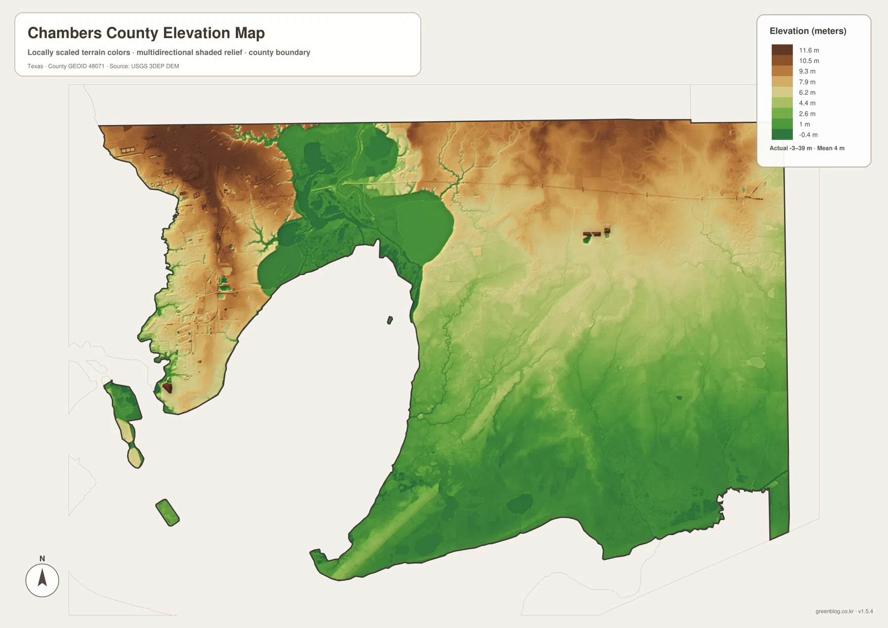
The supplied elevation map reports an actual countywide range of approximately -3 to 39 meters and a mean elevation near 4 meters. Most of Chambers County is therefore extremely low. Green and light-green terrain covers much of the coastal plain, especially around Trinity Bay, the river estuary, and the southern half. The northwest near Mont Belvieu and Old River-Winfree contains more brown and orange tones, showing that this part of the county is relatively higher even though the absolute elevations remain modest.
The Trinity River estuary cuts a conspicuous low area into the northern part of the map. Green terrain follows the river and wetland system, while slightly higher land surrounds it. Farther east, broad areas gradually descend toward the southern coast, with narrow lower lines following bayous. The differences may involve only a few meters across many local areas, but in a county with a mean elevation of about four meters those small changes are enough to create visible topographic patterns.
The southern and southeastern sections are dominated by low coastal terrain. Areas near East Bay and the Intracoastal Waterway remain largely green, and shallow depressions or wetland zones appear across the surface. Unlike an inland hill county, the most useful elevation question here is not where the mountains are, but which parts stand slightly above the surrounding marshy plain and which channels occupy the lowest corridors.
This elevation surface is intended for county-scale comparison. It should not be used to determine the exact elevation of a house, road, levee, industrial site, or parcel, and it does not replace floodplain or emergency-management information. The -3 to 39 meter range and 4 meter mean are best used to understand the unusually low coastal setting and its connection to the county’s bays, river mouth, and bayous.
Why the Northwest Highway Area Looks So Different from the Coastal Lowlands
Mont Belvieu provides the clearest example of the northwest pattern. Interstate 10, Highway 99, local streets, and nearby Old River-Winfree create a dense transportation setting, and the elevation map shows more relatively high ground there than across much of the rest of the county. Moving south toward Beach City and Cove quickly changes the picture. Trinity Bay occupies more of the view, elevations drop, and shoreline shape becomes more important than highway density.
East of Anahuac, settlement becomes more widely spaced and long drainage lines become easier to notice. Interstate 10 and Highway 65 remain major travel references, but East Fork Double Bayou and Oyster Bayou cross the plain to the south. Around Winnie and Stowell, roads are separated by large areas of low land rather than by a continuous urban fabric. The water and elevation maps explain much of that difference without relying on generic descriptions of a rural county.
The southern Highway 124 corridor and the Gulf Intracoastal Waterway show the county’s coastal character most directly. In this area, waterways and very low relief are more useful orientation features than a large city center. In the northwest, by contrast, Mont Belvieu and Interstate 10 are the first things most readers will notice. Chambers County therefore changes character substantially from one side to another, even though the administrative boundary connects all of these places.
Choosing a Chambers County File for Roads, Water, or Elevation
The general county map is the best single image for locating Mont Belvieu, Anahuac, Beach City, Cove, Interstate 10, and the major state highways. The ranked city map is cleaner when the goal is to compare the five mapped communities and their positions around the bay. For Trinity River, Trinity Bay, East Bay, the bayous, and the Intracoastal Waterway, the terrain-and-water map provides much clearer labels. The elevation map is the most direct choice for explaining why the northwest sits above the very low estuary and coastal plain.
Small bayou labels and narrow shoreline features can be difficult to read in a reduced browser preview. The original JPG files are more useful when the map needs to be enlarged or printed. They also work well for side-by-side comparison with Harris, Liberty, Jefferson, or Galveston County, especially when the same map type and similar display scale are used.
The ZIP below contains four high-resolution JPG files corresponding to the county, city, water, and elevation maps shown in the article. They can be enlarged for detailed label reading, printed for classroom or personal reference, or arranged with neighboring county maps for regional comparison.
Frequently Asked Questions
Which community ranks first on the supplied Chambers County city map?
The city index places Mont Belvieu first at 9,020. It is followed by Beach City at 3,309, Anahuac at 2,892, Old River-Winfree at 2,448, and Cove at 378. These figures are the values printed on the supplied ranked-city map.
Why does Trinity Bay occupy such a large part of the county map?
Trinity Bay extends deeply into the western and central part of Chambers County, and the Trinity River estuary reaches it from the north. The supplied water map also shows Galveston Bay, East Bay, smaller bays, bayous, and the Gulf Intracoastal Waterway, making the county’s coastal setting much easier to see.
How low is Chambers County on the supplied elevation map?
The map reports an actual elevation range of about -3 to 39 meters and a mean near 4 meters. The northwest is relatively higher, while Trinity Bay, the river estuary, and much of the southern coastal plain occupy very low ground. This map is not a substitute for survey or flood-risk data.
Sources and Reference Data
- U.S. Census Bureau TIGER/Line Shapefiles — official geographic boundary, road, and place data.
- USGS National Hydrography — official information about rivers, bayous, bays, and other hydrography.
- USGS 3D Elevation Program — official elevation and terrain data information.
- USGS The National Map Viewer — interactive access to boundaries, transportation, hydrography, terrain, and other geographic layers.
Map File Information
Download the Chambers County county, city, water, and elevation maps together as high-resolution JPG files.
- Included Files: 4 maps
- File Type: JPG
Related Maps
- Waller County Texas map
- Orange County Texas map
- Polk County Texas map
- San Jacinto County Texas map
- Wharton County Texas map
Green Map creates custom-edited map images using open geographic data sources such as geoBoundaries, Natural Earth, OpenStreetMap, and government open data.
These maps are edited visual materials, not raw data files, and are provided for education, documents, presentations, and graphic reference.