Cherokee County in East Texas is long from north to south, with Jacksonville, Rusk, Alto, and Wells forming a loose chain through a landscape cut by creeks and wooded ridges. US 69 provides the easiest transportation reference because it runs from the Jacksonville area toward Rusk and Alto, while several east-west highways connect smaller communities such as New Summerfield, Gallatin, and Reklaw. Water adds another layer to the county: Lake Palestine lies along the northwestern side, smaller lakes cluster around Jacksonville, and Mud Creek, Box Creek, Bowles Creek, and many unnamed tributaries occupy the interior. The supplied elevation map ranges from about 56 to 233 meters with a mean near 120 meters, revealing far more relief than the road map alone suggests. The county, city, water, and elevation maps shown here are also available together as four high-resolution JPG files in a ZIP download.
Jacksonville and Rusk are the best places to establish orientation. Jacksonville has the densest road and built-up pattern in the north, while Rusk lies farther south near the interior of the county and serves as the county seat. Alto and Wells extend the settlement pattern toward the southern end, New Summerfield sits northeast of Jacksonville, and Gallatin and Reklaw help locate the eastern side. Once those places are familiar, the terrain maps become easier to read because the broad spaces between towns resolve into narrow creek valleys, reservoirs, and alternating ridges rather than empty land.
Table of Contents
US 69 Links Jacksonville, Rusk, and Alto Through the County
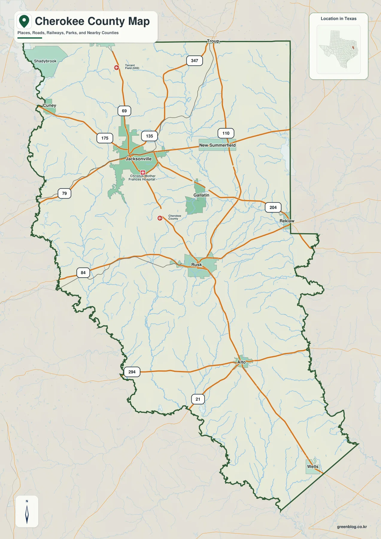
Jacksonville is the most visually complex city on the general county map. US 69 enters from the north and passes through the built-up area, while routes 79 and 175 approach from the west. Routes 135 and 347 provide additional references around the city. Tarrant Field is labeled north of Jacksonville, and Christus Mother Frances Hospital appears just south of the main urban area, helping distinguish the broader Jacksonville road cluster from the smaller towns elsewhere in the county.
Following US 69 south leads toward Rusk. Here, Highway 84 crosses east and west, while routes 110 and 204 help connect the eastern side through New Summerfield, Gallatin, and Reklaw. Rusk is less road-dense than Jacksonville, but it occupies a useful central position because several routes leave the city in different directions. The county-related marker north of town also reinforces Rusk’s role as the administrative reference point without requiring the reader to treat it as the county’s largest urban center.
The same north-south route continues toward Alto, where routes 294 and 21 are visible nearby. Wells lies farther southeast near the narrow southern tip of the county. This elongated settlement pattern is one of the most useful features on the map. Jacksonville, Rusk, Alto, and Wells do not merge into a continuous developed corridor; instead, they are separated by large stretches of rural land, creeks, and rolling terrain.
The western edge is markedly irregular in places, especially near the Lake Palestine and Neches River side of the county. Roads do not simply parallel that boundary, and the topographic maps show why: water and creek valleys cut into the western landscape while ridges rise nearby. The eastern side includes longer straight boundary segments, with New Summerfield and Reklaw offering good place references for locating the county’s eastern reach.
Six Ranked Cities Reveal a Strong Jacksonville Lead and a Long North-South Spread
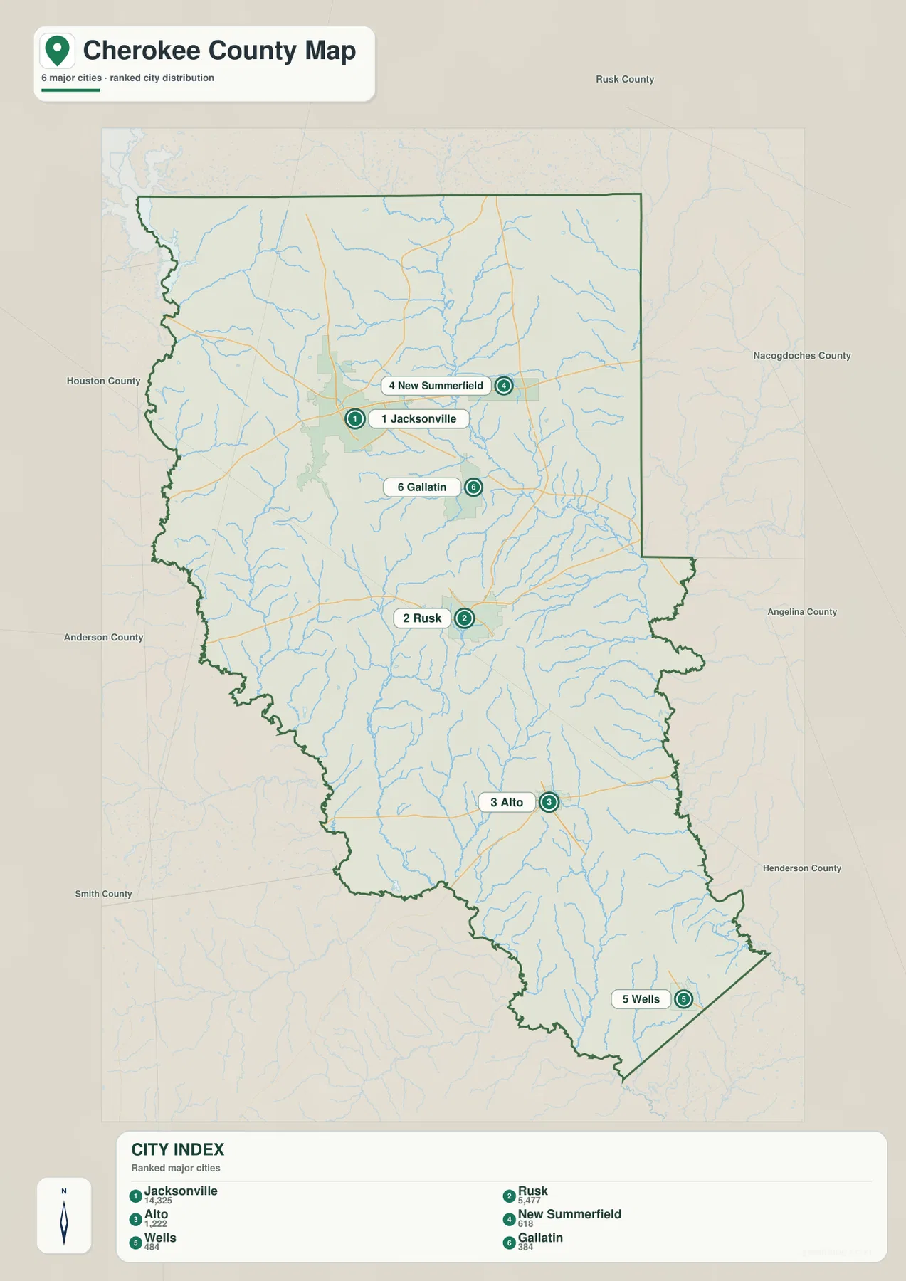
The ranked city map highlights six communities and deliberately removes much of the road detail. Its index lists Jacksonville at 14,325, Rusk at 5,477, Alto at 1,222, New Summerfield at 618, Wells at 484, and Gallatin at 384. Jacksonville is therefore the largest value printed on the supplied city map, with Rusk clearly second. Alto is much smaller and farther south, while the three remaining communities provide location references for the northeast, east-central, and far southern parts of the county.
This city map does not draw connector lines or print city-to-city mileages, so the ranking numbers should not be mistaken for distances. Its purpose is distribution rather than travel time. The spacing shows that Jacksonville and Rusk are separated by a broad rural area, and the same is true between Rusk and Alto. Cherokee County therefore has several distinct community centers rather than one continuous urbanized strip.
New Summerfield is northeast of Jacksonville, Gallatin sits east of the main Jacksonville–Rusk line, and Wells is near the southeastern end of the county. Those small places are valuable on the map because they give shape to areas that would otherwise be difficult to describe. Wells, for example, makes the length of the southern extension immediately apparent, while New Summerfield and Gallatin help place the broad eastern half.
Outside labels include Rusk County, Nacogdoches County, Angelina County, Henderson County, Anderson County, and Houston County. Once the six Cherokee County communities are located, those neighboring names make regional direction easier to understand. Jacksonville is closer to the northern and northwestern side of the county, while Alto and Wells sit nearer the southern and southeastern neighbors.
Lake Palestine, Jacksonville Lakes, Mud Creek, and the Southern Creek Network
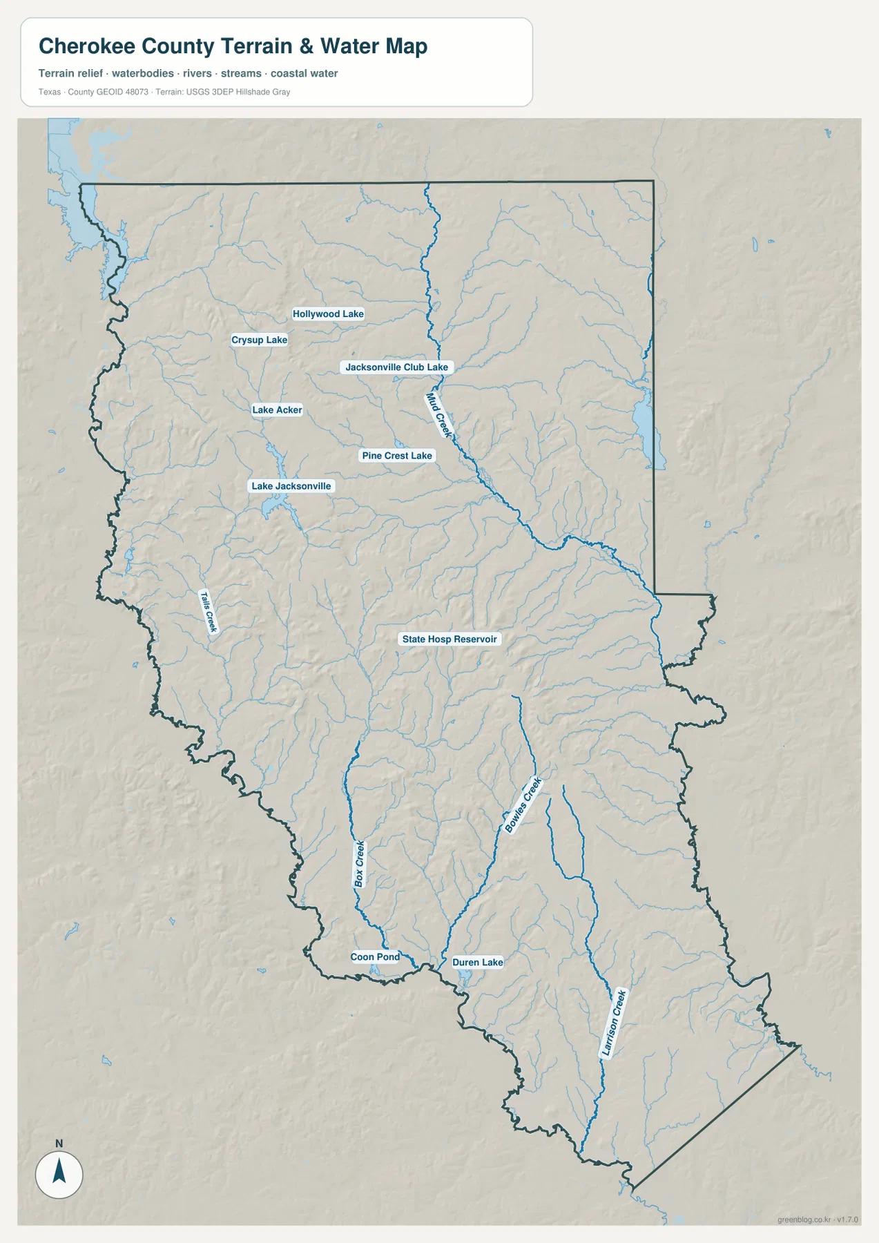
The terrain-and-water map shifts attention away from highways. A large water body appears along the northwestern side in the Lake Palestine direction, while the Jacksonville area contains several named lakes: Hollywood Lake, Crysup Lake, Jacksonville Club Lake, Lake Acker, Pine Crest Lake, and Lake Jacksonville. Their concentration gives the northern part of the county a much more water-rich appearance than the general road map suggests.
Mud Creek is one of the strongest named drainage lines in the northern and central part of the supplied map. It descends from the north and bends southeast through a broad low corridor, collecting numerous smaller tributaries. The channel is especially useful for orienting the land east of Jacksonville and north and east of Rusk. State Hosp Reservoir appears farther south in the central county, adding another labeled water reference close to the Rusk area.
Farther south, Box Creek and Bowles Creek become prominent. Box Creek follows a long valley in the southwestern half, while Bowles Creek occupies a separate drainage line farther east. Coon Pond and Duren Lake are labeled near the southern side, and another long creek continues toward the southeastern end. These waterways show that the broad rural area between Alto and the county edges is divided by many narrow valleys rather than forming one featureless surface.
The existing county source also identifies the Neches River and Lake Palestine as major western water references. Those features fit the irregular western boundary visible on the county and terrain maps. The supplied water image is intended for general geographic reading, not flood-hazard analysis, parcel boundaries, water depth, or navigation. For those questions, purpose-built official data should be used. Here, the useful task is simply to locate named lakes and creeks and compare them with nearby towns and relief.
Elevation from About 56 to 233 Meters Creates a Ridge-and-Valley Landscape
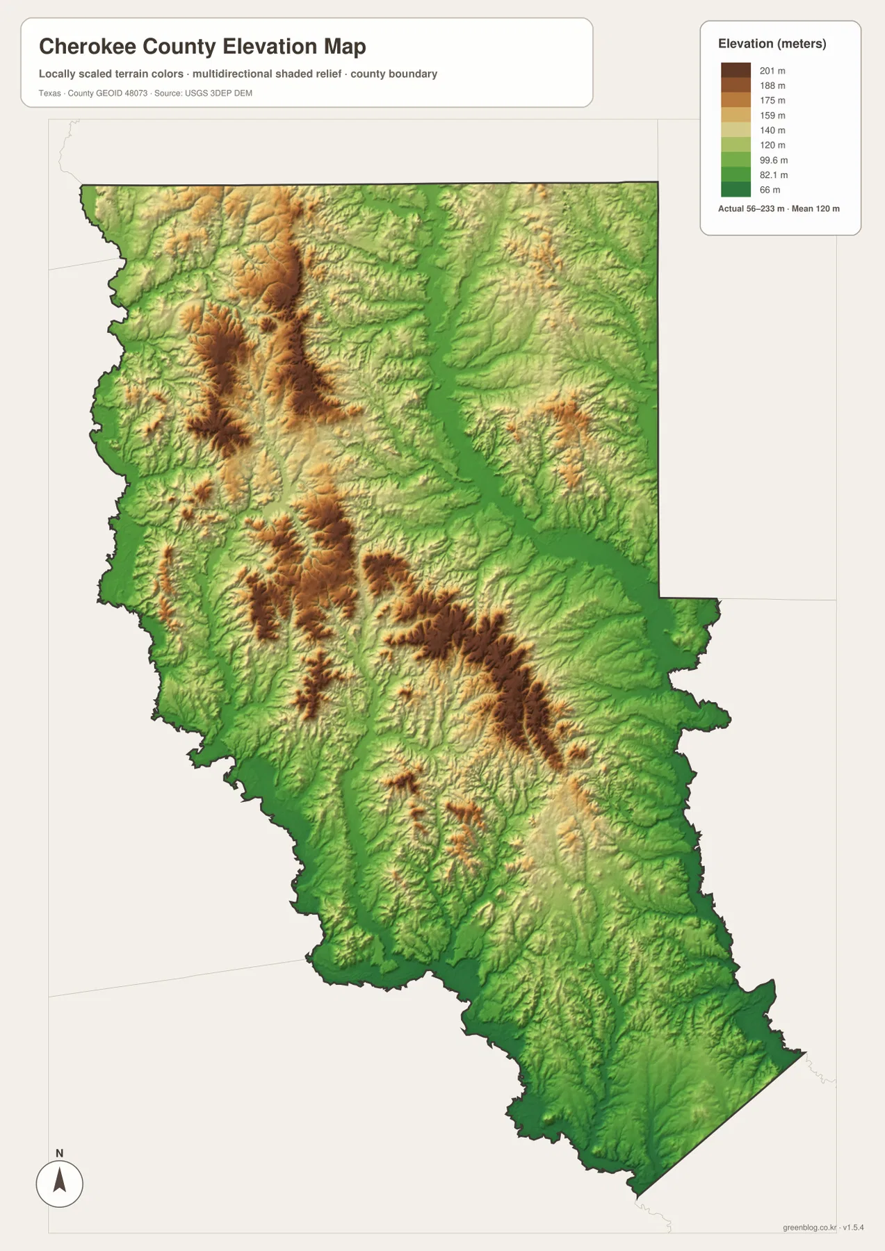
The supplied elevation map reports an actual range of approximately 56 to 233 meters and a mean near 120 meters. The strongest higher terrain appears in the northwest and west-central county, with additional brown ridges extending through the central and east-central areas. The high ground west and southwest of Jacksonville is especially conspicuous, and another set of ridges occupies the country north and east of Rusk.
Green lowlands cut between those ridges. One of the broadest low corridors follows the north-central to southeastern drainage associated with Mud Creek, while the western side drops toward the Neches River and Lake Palestine system. Matching the water and elevation maps makes the connection obvious: the named creeks occupy lower channels between the ridges rather than crossing the highest brown terrain at random.
The southern half has fewer large high-elevation patches than the northwest, but it is still strongly rolling. Small ridges recur around Alto and farther south, while the Box Creek and Bowles Creek valleys appear as lower corridors. The southeastern tip around Wells is generally lower in color, although local ridges remain. The county therefore does not descend in one simple direction; its relief is a repeated sequence of uplands and drainage lines.
This elevation surface is suitable for county-scale comparison, not survey or engineering measurement. It should not be used to determine the precise height of a house, parcel corner, road grade, or construction site. The 56–233 meter range and 120 meter mean are best treated as broad reference values showing how much local relief exists between the county’s wooded ridges and creek valleys.
Why the Jacksonville–Rusk Corridor Looks Simpler on the Road Map Than on the Terrain Maps
US 69 makes Jacksonville and Rusk appear to form a straightforward north-south corridor. The water and elevation maps reveal a more complicated setting. Numerous small tributaries cross the land around the highway, Mud Creek occupies a broad lower corridor to the east, and higher ridges rise west of Jacksonville and around the central county. The road connection is direct, but the surrounding physical geography is anything but flat.
The northwest is a particularly strong example. Lake Palestine and the western drainage sit beside some of the highest brown terrain on the elevation map. Low water corridors and high ridges occur within a short map distance, creating a sharper local contrast than in much of the southern county. This helps explain why the western road pattern is less grid-like than it would be on a uniformly flat plain.
South of Rusk, settlement thins and the terrain layer takes over visually. Around Alto and toward Wells, creeks and small ridges occupy far more of the map than urban streets. Box Creek and Bowles Creek provide useful water references, while the elevation surface shows the valleys that contain them. The southern extension therefore feels very different from Jacksonville even though US 69 and related highways keep the county connected.
Choosing the Best Cherokee County File for Roads, Cities, Water, or Relief
The general county map is the most complete single reference for Jacksonville, Rusk, Alto, New Summerfield, the county boundary, and major roads such as US 69, Highway 84, Route 110, and Route 204. The ranked city map is cleaner when the task is to compare the six mapped communities and their positions. The water map is the best choice for Lake Jacksonville, Mud Creek, Box Creek, Bowles Creek, and the many smaller lakes and tributaries. The elevation map is most useful when the higher northwest and central ridges need to be compared with lower creek corridors.
Small creek labels and road numbers can be difficult to read in a reduced browser preview. The original JPG files are more convenient for enlargement and printing. They also work well for side-by-side comparison with Anderson, Angelina, Nacogdoches, Rusk, Smith, or other East Texas counties, especially when the same map type and similar display scale are used.
The ZIP below contains four high-resolution JPG files corresponding to the county, city, water, and elevation maps shown in the article. They can be enlarged for detailed label reading, printed for classroom or personal reference, or arranged with neighboring county maps for regional comparison.
Frequently Asked Questions
Which place ranks first on the supplied Cherokee County city map?
Jacksonville ranks first at 14,325 on the supplied index, followed by Rusk at 5,477 and Alto at 1,222. New Summerfield, Wells, and Gallatin are also shown, giving useful reference points for the northeast, far south, and east-central portions of the county.
Which water features are easiest to identify on the supplied terrain-and-water map?
Lake Jacksonville and several smaller lakes are labeled around the Jacksonville area, while Mud Creek is prominent through the north-central county. Box Creek and Bowles Creek are strong references farther south. Lake Palestine and the Neches River also help orient the western side of Cherokee County.
How much elevation variation does the Cherokee County map show?
The supplied elevation map reports a range of about 56–233 meters and a mean near 120 meters. Higher ridges are concentrated in the northwest and central county, while the Neches River, Mud Creek, and southern creek valleys occupy lower terrain. The map is intended for county-scale comparison rather than survey work.
Sources and Reference Data
- U.S. Census Bureau TIGER/Line Shapefiles — official geographic boundary, road, and place data.
- USGS National Hydrography — official information about rivers, creeks, lakes, and hydrography.
- USGS 3D Elevation Program — official elevation and terrain data information.
- USGS The National Map Viewer — interactive access to boundaries, transportation, hydrography, terrain, and other geographic layers.
Map File Information
Download the Cherokee County county, city, water, and elevation maps together as high-resolution JPG files.
- Included Files: 4 maps
- File Type: JPG
Related Maps
- Anderson County Texas map
- Angelina County Texas map
- Nacogdoches County Texas map
- Rusk County Texas map
- Smith County Texas map
Green Map creates custom-edited map images using open geographic data sources such as geoBoundaries, Natural Earth, OpenStreetMap, and government open data.
These maps are edited visual materials, not raw data files, and are provided for education, documents, presentations, and graphic reference.