Childress County in North Texas is organized around a striking physical feature as much as a town or highway: Prairie Dog Town Fork Red River crosses the middle of the county in a broad, low valley. Childress sits south of that river corridor and serves as the clearest road and settlement reference, while Kirkland, Tell, and Arlie provide smaller location markers toward the county edges. US 287 runs through Childress toward Kirkland, and the water map labels a dense set of creeks plus Lake Childress, Williams Reservoir, Park Lake, and other small water bodies. The elevation surface ranges from about 474 to 628 meters with a mean near 545 meters, showing high rolling terrain in the west and southwest above the central river valley and lower eastern ground. Four matching high-resolution JPG files—the county, city, water, and elevation maps—are available together in the ZIP download on this page.
For orientation, start with Childress and US 287. The city lies in the south-central portion of the county, while US 287 approaches from the northwest and leaves toward Kirkland in the southeast. The existing county article also identifies the US 62/83 corridor through Childress as another major regional connection. North of the city, the Prairie Dog Town Fork valley creates the largest break in the terrain, separating the more dissected northern uplands from the rolling country around Childress and the southern half.
Table of Contents
US 287 Makes Childress the Easiest Road Reference in the County
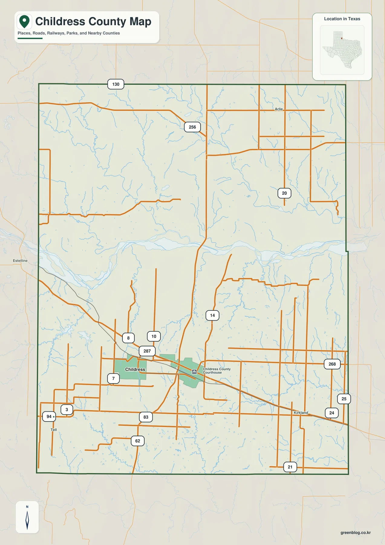
The general county map gives Childress the strongest built-up footprint. US 287 enters from the northwest, passes through the city, and continues southeast toward Kirkland. Other numbered highways and rural routes converge around the same area, including the regional US 62/83 corridor described in the existing county source. The Childress County Courthouse is marked east of the central built-up area, adding an easy administrative landmark to the road network.
Kirkland lies southeast of Childress and close to US 287, so it is straightforward to locate once the main highway is established. Tell appears near the southwestern side, while Arlie is marked far to the northeast. These are much smaller place labels than Childress, but they are useful because they give the broad rural parts of the county recognizable endpoints. Their positions also make clear that Childress County extends a substantial distance in both east-west and north-south directions beyond the city itself.
The road pattern changes north of the Prairie Dog Town Fork valley. Small tributaries are far more numerous there, and the terrain is more deeply cut, so local roads do not form the same simple pattern seen around parts of the southern county. Routes 256, 20, and 130 appear as useful northern references, but the map is visually dominated by the many creek crossings rather than by one continuous urban corridor.
South and west of Childress, many rural roads contain long straight segments. Eastward toward Kirkland, a similar grid appears between the larger highway lines. Yet wherever creek valleys become dense, roads bend or shift course. This contrast is easier to understand when the county map is placed beside the terrain-and-water image: the road network responds to a landscape that rolls into numerous tributaries rather than to a completely level plain.
The Ranked City Map Contains One Major City: Childress
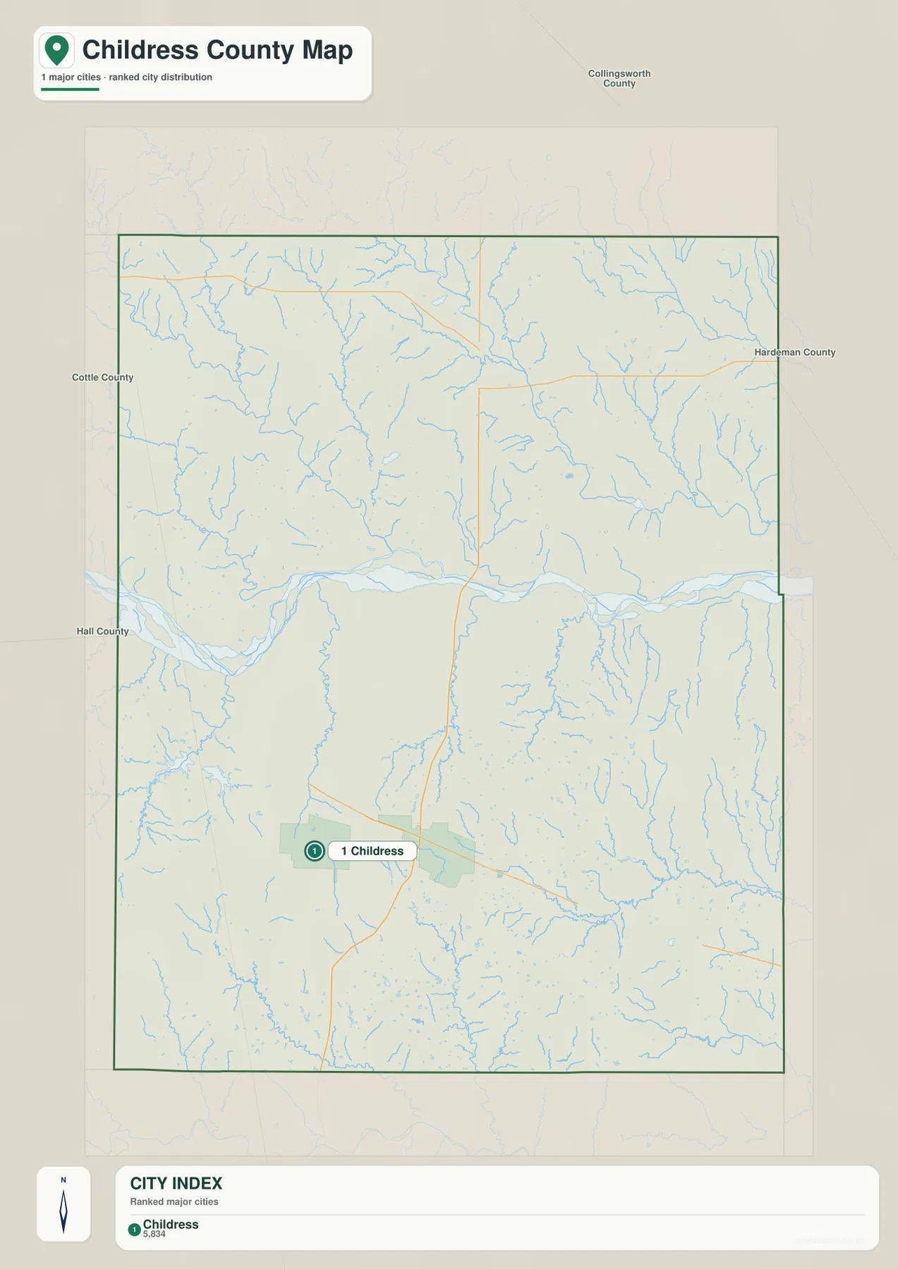
The supplied city-distribution map is unusually simple. Its subtitle states that one major city is ranked, and the CITY INDEX lists Childress at 5,834. No second ranked city is plotted, so this map is not a connector-distance diagram and it does not support a city-to-city ranking comparison. Instead, it emphasizes where Childress sits within the full county boundary.
Childress lies south of the large Prairie Dog Town Fork valley, which is visible even on the simplified city map. Numerous tributaries fill the northern half and continue across the eastern and western sides. Because most of the settlement detail has been removed, the relationship between the city point, the river corridor, and the broad rural area becomes particularly easy to see.
Neighboring county labels include Collingsworth County to the north, Hardeman County to the east, Cottle County to the west, and Hall County toward the west and southwest. These outside labels help show how far Childress is offset toward the southern half of its own county. The northern boundary is a long distance from the city, while the western and eastern edges contain far more drainage detail than urban labels.
The 5,834 value should be read as the figure printed on the supplied city index rather than as a substitute for a current population estimate. The map’s purpose is geographic placement. Smaller named communities such as Kirkland, Tell, and Arlie remain available on the general county map even though they are not included in this ranked-city layer.
Prairie Dog Town Fork Red River Defines the Broad Central Valley
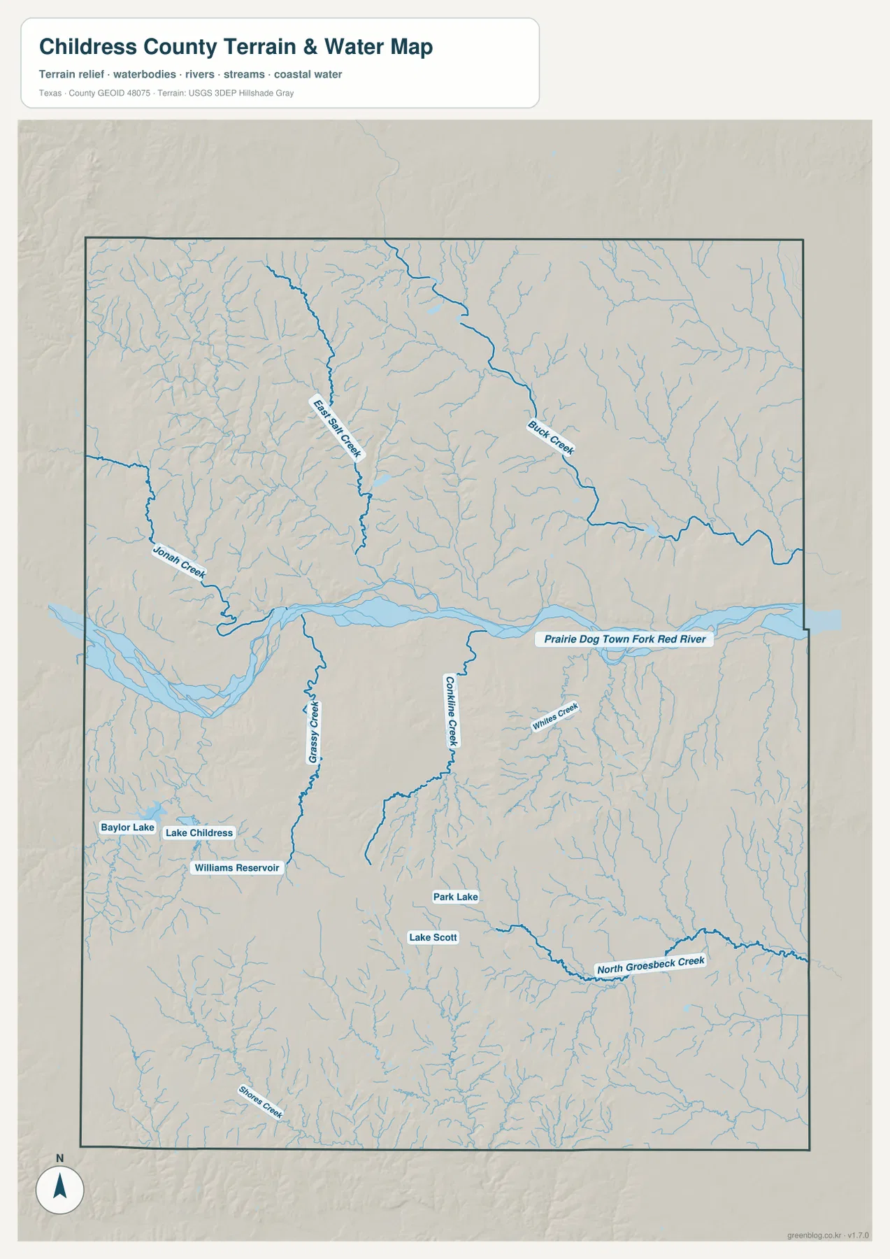
The most prominent water feature is Prairie Dog Town Fork Red River. It enters from the west, bends broadly across the center of the county, and continues eastward. Numerous tributaries approach from both sides, giving the river a much larger visual presence on the terrain-and-water map than on the general road map. Its valley effectively separates the more dissected northern terrain from the southern area around Childress.
North of the main river, Jonah Creek, East Jop Creek, and Birch Creek are among the clearest named tributaries. Birch Creek descends through the northeastern part of the county toward the main drainage, while Jonah Creek reaches the river from the northwest. Many smaller unnamed streams fill the spaces between them. On the elevation map, these channels correspond to branching green valleys cut through the higher northern and northwestern terrain.
South of the Prairie Dog Town Fork, the map labels Grass Creek, Combline Creek, and Whites Creek, with North Groesbeck Creek extending across the southeastern portion. Several water bodies cluster near Childress: Baylor Lake, Lake Childress, and Williams Reservoir lie to the west and southwest of the city, while Park Lake and Lake Scott are farther east and southeast. The southern county therefore contains a meaningful mix of tributaries and small reservoirs rather than one uninterrupted plain.
This terrain-and-water image is intended for general geographic reference. It is not a flood-hazard map, parcel map, depth chart, water-quality report, fishing-status map, or navigation product. Those uses require specialized official information. Here, its value is in showing where Prairie Dog Town Fork Red River, the named creeks, and the small lakes sit relative to Childress, the roads, and the relief.
Elevation from About 474 to 628 Meters Shows a Deep River Valley
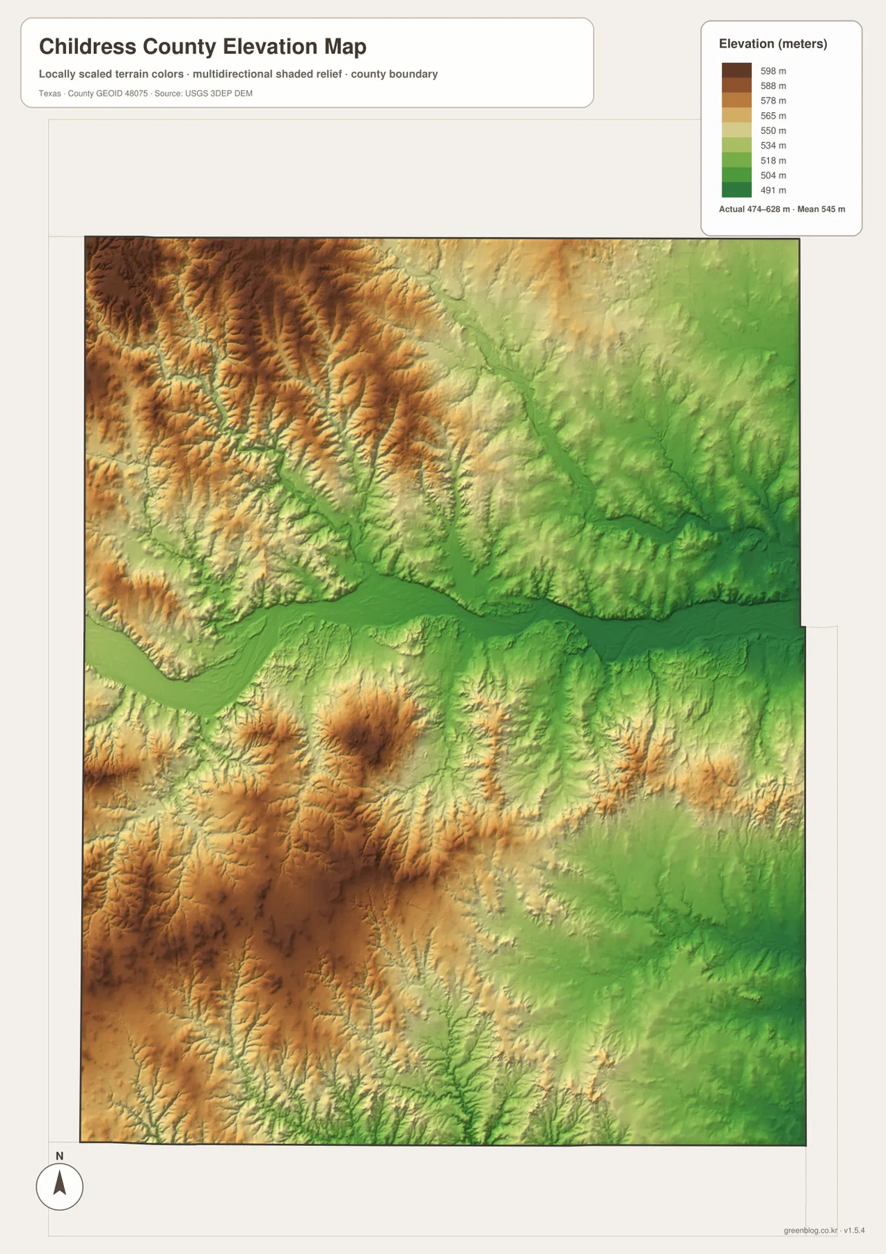
The supplied elevation map reports an actual range of approximately 474 to 628 meters and a mean near 545 meters. The highest brown terrain is concentrated in the northwest and west, with another broad high area in the southwest. In contrast, the Prairie Dog Town Fork corridor appears as a continuous dark-green low belt through the county center. Eastern and northeastern terrain also tends to be lower than the western uplands.
The northwest is not a smooth plateau. Branching creek valleys slice into the higher surface, producing a dense ridge-and-gully texture. When Jonah Creek and East Jop Creek are located on the water map, their positions align with obvious low green channels on the elevation surface. Farther northeast, Birch Creek occupies another long lower route across terrain that has already dropped from the higher western side.
The southern half contains strong relief as well. High orange and brown ground rises west and southwest of Childress, while narrow green valleys descend toward the main river and smaller creeks. East of the city toward Kirkland, lower green terrain becomes more extensive. North Groesbeck Creek also occupies a recognizable low corridor in the southeast. These differences help explain why the road environment changes as US 287 crosses from higher western rolling country toward lower eastern terrain.
The elevation surface is suitable for county-scale comparison, not survey or engineering measurement. It should not be used to determine the exact elevation of a house, parcel corner, road grade, or construction site. The 474–628 meter range and 545 meter mean are best treated as broad reference values showing how deeply the river and tributary valleys divide the rolling terrain.
US 287 Looks Different Once the River Valley and Relief Are Added
US 287 is easy to follow on the county map, but the terrain layers explain what surrounds it. Northwest of Childress, the route approaches the city through rolling ground cut by numerous tributaries. Southeast of Childress, the landscape becomes generally lower as the highway continues toward Kirkland. The road itself remains a strong diagonal reference, yet its physical setting changes noticeably across the county.
The Prairie Dog Town Fork valley is equally important for north-south orientation. It creates a broad low corridor between the northern uplands and the Childress area. Roads that cross this part of the county must pass through the lower river setting before climbing back into higher ground. Matching a road crossing on the county map with the elevation colors makes that change far more obvious than either map alone.
The western and eastern sides provide a useful contrast. Tell is closer to the higher rolling country in the west, while Kirkland lies toward generally lower eastern terrain. Childress sits between those settings and collects the county’s most important road lines, making it the most practical place to use as a reference when moving among the four map types.
Choosing the Best Childress County File for Roads, Water, or Relief
The general county map is the best single reference for Childress, Kirkland, Tell, Arlie, US 287, and the surrounding road network. The ranked city map is cleaner when only the location of Childress needs to be emphasized. The terrain-and-water map is the best choice for Prairie Dog Town Fork Red River, Jonah Creek, Birch Creek, Lake Childress, and the other named water features. The elevation map most clearly shows the contrast between the high western rolling terrain and the broad central river valley.
Small creek labels and minor route numbers may be difficult to read in a reduced browser preview. The original JPG files are more convenient for enlargement and printing. They also work well for comparison with nearby counties such as Cottle, Hall, Hardeman, and Collingsworth when the same map type and similar scale are used.
The ZIP below contains four high-resolution JPG files corresponding to the county, city, water, and elevation maps shown in the article. They can be enlarged for detailed label reading, printed for classroom or personal reference, or arranged with neighboring county maps for regional comparison.
Frequently Asked Questions
Why does the ranked city map show only Childress?
The supplied city layer ranks one major city and lists Childress at 5,834 in the CITY INDEX. Smaller named places such as Kirkland, Tell, and Arlie remain visible on the general county map but are not part of this ranked-city layer.
Where does Prairie Dog Town Fork Red River cross the county?
It crosses the central part of Childress County from west to east in a broad, low valley. Childress lies south of the river, while Jonah Creek, East Jop Creek, and Birch Creek are among the named tributaries entering from the northern side.
How much elevation variation appears on the supplied Childress County map?
The elevation map reports an actual range of about 474–628 meters and a mean near 545 meters. The west and southwest are generally higher, while Prairie Dog Town Fork Red River and many tributary valleys occupy lower terrain. The image is intended for county-scale comparison rather than survey work.
Sources and Reference Data
- U.S. Census Bureau TIGER/Line Shapefiles — official geographic boundary, road, and place data.
- USGS National Hydrography — official information about rivers, creeks, lakes, and hydrography.
- USGS 3D Elevation Program — official elevation and terrain data information.
- USGS The National Map Viewer — interactive access to boundaries, transportation, hydrography, terrain, and other geographic layers.
Map File Information
Download the Childress County county, city, water, and elevation maps together as high-resolution JPG files.
- Included Files: 4 maps
- File Type: JPG
Related Maps
- Wheeler County Texas map
- Motley County Texas map
- Wilbarger County Texas map
- Armstrong County Texas map
- Stonewall County Texas map
Green Map creates custom-edited map images using open geographic data sources such as geoBoundaries, Natural Earth, OpenStreetMap, and government open data.
These maps are edited visual materials, not raw data files, and are provided for education, documents, presentations, and graphic reference.