This Stonewall County Map set is organized around Aspermont, where U.S. 83 and U.S. 380 provide the clearest road references. Download the high-resolution A3 JPG map ZIP from the box below when you need printable or editable files; it contains separate county-reference, city, terrain-and-water, and elevation maps. Together they show the county’s road network, Brazos River forks, creek valleys, small lakes, and a strong contrast between high western terrain and lower land to the east.
Stonewall County is not a place where several large towns compete for attention. Aspermont is the single ranked major city on the supplied maps, but the physical landscape is varied. The Salt Fork Brazos River occupies a major northern and western drainage corridor, the Double Mountain Fork Brazos River crosses the south, and multiple creeks cut through the interior. The elevation map explains those channels by showing broad high ground in the west and southwest separated by lower valleys.
Table of Contents
U.S. 83 and U.S. 380 meet at Aspermont
Aspermont is the most useful starting point on the county reference map. U.S. 83 runs north-south through the town, while U.S. 380 crosses from west to east. Their intersection gives the map a simple frame: north and south can be followed along 83, and the western and eastern halves can be compared along 380. Local route labels such as 350, 325, 528, 411, and 476 add detail for the rural interior without changing that basic orientation.
Oriana is marked west of Aspermont with a historical designation, and Two D Crossing appears in the northeastern part of the county. Jayton is labeled outside the western boundary and Rochester outside the northeast, providing useful references beyond the county line. With relatively few settlement names, these smaller labels help show the scale of the rural interior and the distance between Aspermont and the outer edges.
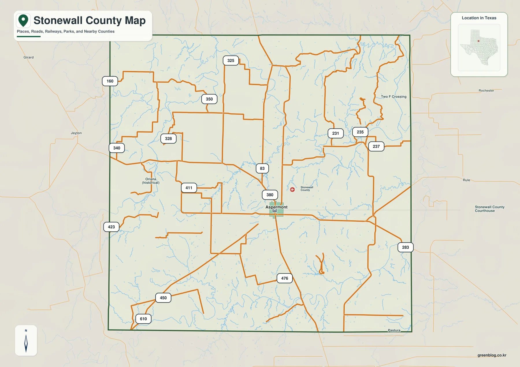
The blue drainage lines make the road map look much more intricate than a simple highway diagram. Tributaries branch heavily in the northeast and south, while the main highways stay comparatively straight. That contrast is useful: the reference layer establishes where people travel, and the water and elevation views explain the terrain that those roads cross.
The city view gives Aspermont a single clear location marker
The ranked city map highlights only Aspermont. With most local road numbers and secondary place labels removed, the city marker stands slightly south of the county’s center and the surrounding drainage becomes easier to see. This is not a city-ranking map in the usual sense; its main purpose is to give one unmistakable settlement reference inside a large rural county.
The CITY INDEX prints Aspermont at 920. That figure should be read as the value used in the supplied graphic rather than as a guaranteed current population estimate. Anyone needing a current demographic total should consult an official statistical source. For map reading, the key point is that Aspermont is the only major city ranked here and therefore becomes the anchor for roads, waterways, and neighboring counties.
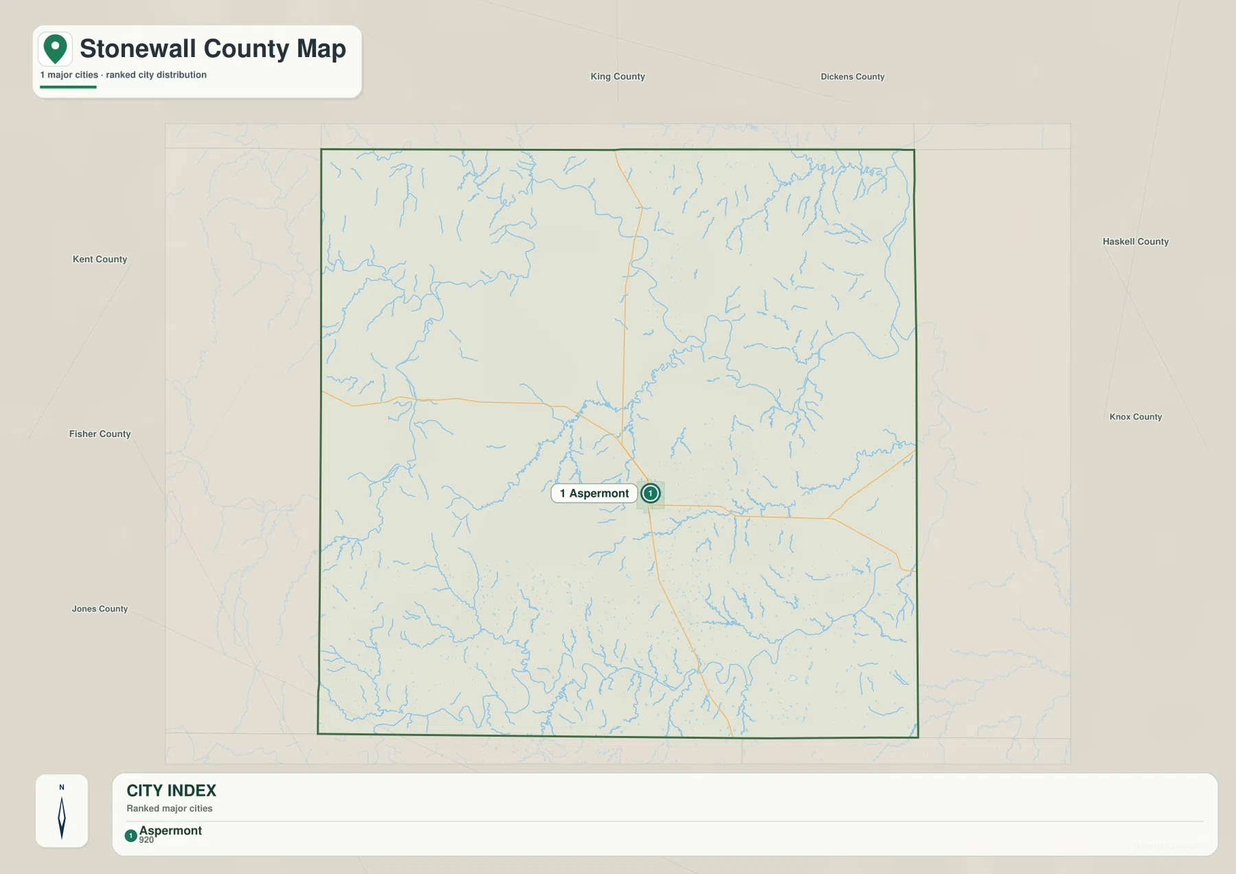
The neighboring county names provide another useful frame. King and Dickens counties are shown to the north, Haskell and Knox to the east, Kent to the west, and Fisher and Jones toward the southwest and south. Because Aspermont is the only strong city marker, those outer labels help place Stonewall County within the surrounding northwestern Texas counties without overcrowding the map.
Salt Fork and Double Mountain Fork divide the county into major drainage corridors
The terrain-and-water map is easiest to read by starting with the largest named channels. The Salt Fork Brazos River occupies the northwestern and western side, while the Double Mountain Fork Brazos River forms a long southern corridor. In the northeast, a channel labeled Brazos River follows the county edge, with Weddington Creek and North Croton Creek nearby. These large features divide the map into broad drainage areas before the smaller creeks are considered.
Stinking Creek is a strong central-western reference, and Turtle Creek follows a narrower nearby valley. Tonk Creek crosses the eastern interior and is one of the easiest long tributaries to trace. Aspermont Lake is labeled south of the county’s center, while Landreth Lake appears close to the Salt Fork Brazos River in the northwest. Those lakes are small compared with the river forks, but they provide useful landmarks in areas with relatively few town names.
Additional channels help explain the southern and northern uplands. Salt Creek approaches the southern river corridor from the west, and Willow Creek lies just north of the Double Mountain Fork Brazos River. Salt Croton Creek appears in the northwestern interior, while Womack Creek runs through the northeastern drainage. The simplest way to organize the map is to separate the Salt Fork system in the north and west from the Double Mountain Fork system in the south, then place the smaller tributaries between them.
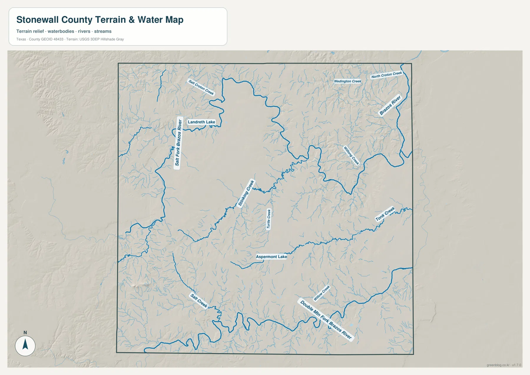
This layer is intended for geographic reference rather than flood-hazard analysis, parcel boundaries, navigation, or water-management decisions. It is most useful for seeing how the major Brazos forks and tributaries occupy different valleys and how those drainage lines relate to the terrain shown on the elevation map.
High western uplands fall toward lower eastern valleys
The elevation map reports an actual range of about 438 to 781 meters and a mean elevation of 536 meters. The strongest brown high ground is concentrated along the west and southwest, with another prominent high area in the west-central interior. By contrast, the east and northeast contain much broader green terrain, indicating substantially lower land.
The western side is not one smooth plateau. Narrow green valleys cut through the high ground, and isolated ridges rise above lower corridors in the center. Eastward, those low areas become more continuous and merge with the Brazos-side valleys. Comparing this map with the water layer shows why the main river forks and long creeks bend through specific parts of the county instead of following straight lines.
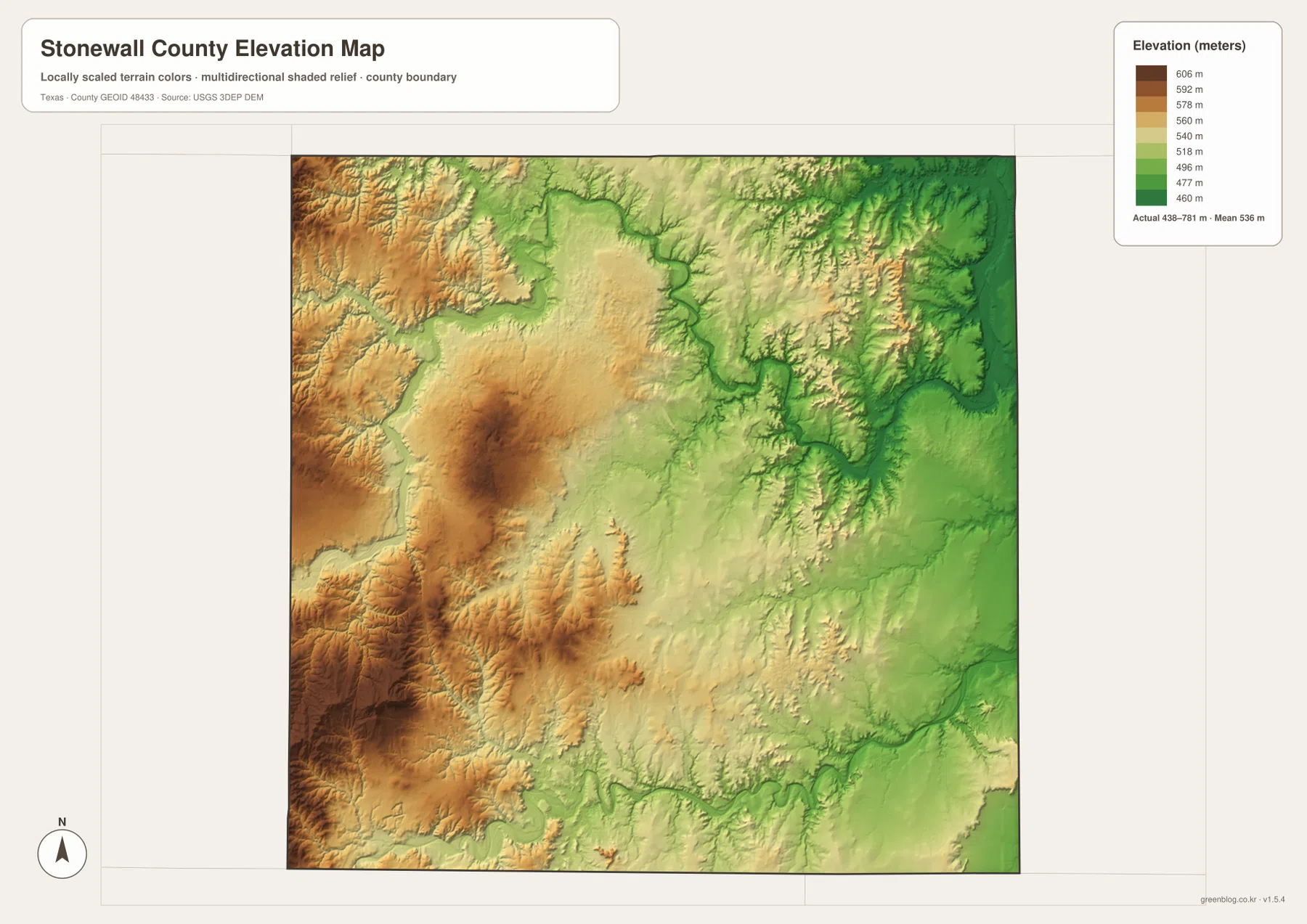
This countywide elevation surface is designed for broad terrain comparison, not parcel surveying or engineering design. It is useful for locating the highest uplands, following lower creek corridors, and comparing the land around Aspermont with the more elevated west and the lower eastern drainage. Exact elevation for a property or structure should be checked with detailed source data or a local survey.
Choose the map by whether roads, river forks, or relief matter most
Use the county reference map when Aspermont, U.S. 83, U.S. 380, local route numbers, and the county boundary need to appear together. The city view is cleaner when Aspermont alone should stand out. The terrain-and-water layer is the best place to trace the Salt Fork Brazos River, Double Mountain Fork Brazos River, Stinking Creek, Tonk Creek, and the named lakes, while the elevation map makes the contrast between western uplands and eastern valleys easiest to compare.
The downloadable ZIP contains four separate high-resolution A3 JPG files for Stonewall County: county reference, ranked city, terrain and water, and elevation. You can inspect the WebP versions in the article first and then use the larger JPG files for printing, classroom material, presentations, or an editable local-reference document.
Frequently Asked Questions
Where do U.S. 83 and U.S. 380 meet?
On the supplied county map, the two highways meet at Aspermont. U.S. 83 provides the main north-south reference, while U.S. 380 crosses the county from west to east.
What are the largest named waterways on the Stonewall County map?
The terrain-and-water map uses the Salt Fork Brazos River in the north and west and the Double Mountain Fork Brazos River in the south as its largest drainage references. A Brazos River channel is also labeled along the northeastern edge.
Which part of Stonewall County is highest?
The elevation map places the strongest high-elevation colors in the west and southwest. The east and northeast are much lower. The actual mapped range is about 438 to 781 meters, with a mean elevation of 536 meters.
Map File Information
The ZIP contains the four Stonewall County maps in high-resolution A3 JPG format.
- Included Versions: County reference, ranked city, terrain and water, elevation
- Included Files: 4 A3 JPG maps
Related Maps
Sources and data references
Roads and county boundaries around Aspermont can be cross-checked with the U.S. Census Bureau TIGER/Line Shapefiles. The Salt Fork Brazos River, Double Mountain Fork Brazos River, creeks, and lake names can be checked against USGS National Hydrography, while terrain height data are available through the USGS 3D Elevation Program. Route labels, place names, water features, and the 438–781 meter elevation range described above are based on the Stonewall County maps supplied in this package.
Green Map creates custom-edited map images using open geographic data sources such as geoBoundaries, Natural Earth, OpenStreetMap, and government open data.
These maps are edited visual materials, not raw data files, and are provided for education, documents, presentations, and graphic reference.