Polk County, Tennessee changes dramatically from the lower western side around Benton and Ocoee to the rugged mountains around Ducktown, Copperhill, Farner, and the eastern boundary. The county map is useful for roads and place names, but the water and elevation views explain why those roads and towns are arranged the way they are. You can download the Polk County Tennessee Map files on this page as one ZIP containing high-resolution JPG versions of the county, city, water, and elevation maps for A3 printing, presentations, classroom work, or local reference.
Benton is the easiest place to use as an anchor. It is the county seat and sits in the western half, where the terrain is generally lower and the road network spreads in several directions. Ocoee lies to the southwest and Delano to the north, while Ducktown and Copperhill form a separate pair in the mountainous southeast. Farner marks the eastern side. Looking at those places on the road map first, and then opening the elevation sheet, makes the county’s strong west-to-east terrain contrast immediately clear.
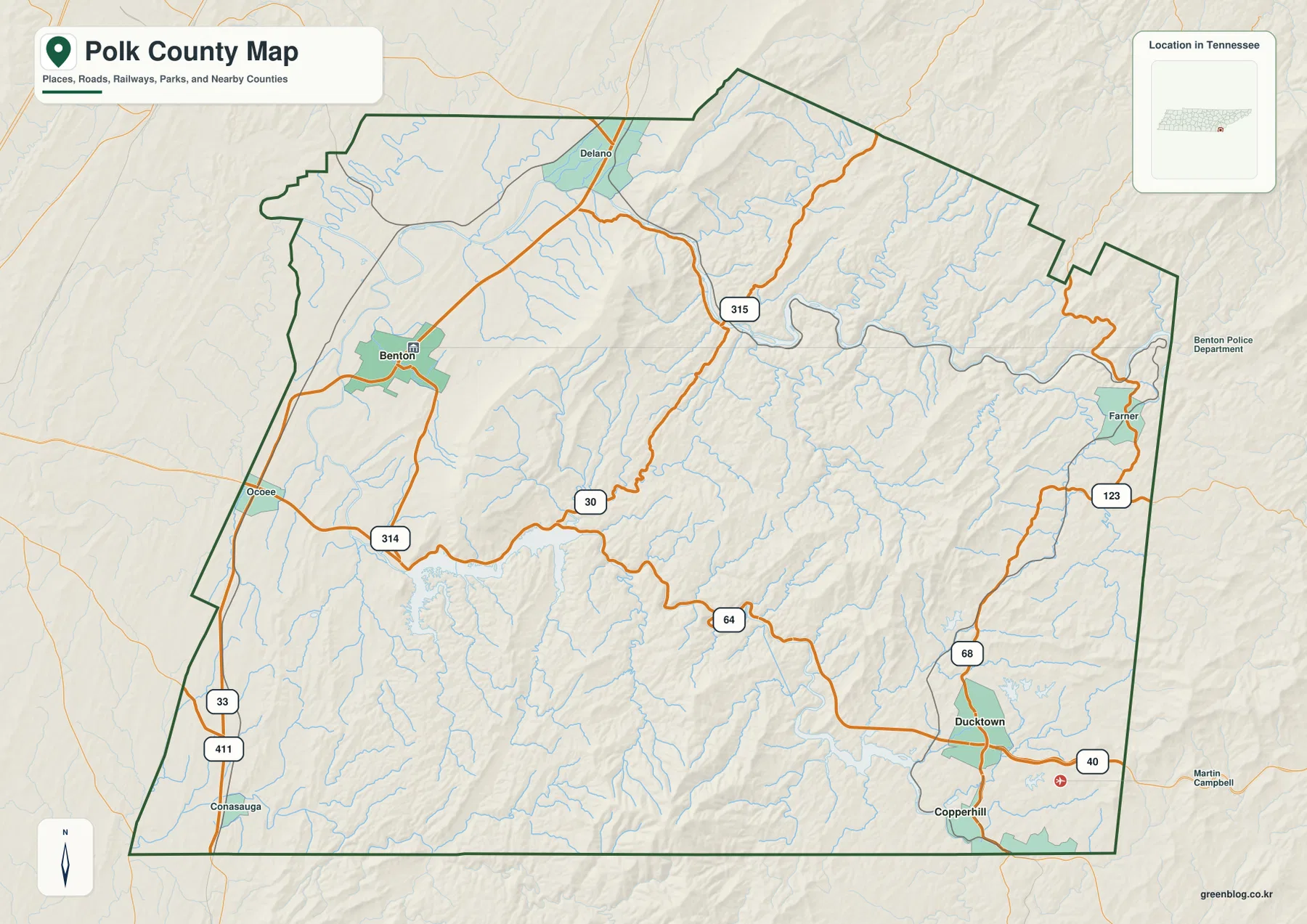
Table of Contents
Benton anchors the lower western road network
Benton sits on the western side of the county where US 411 provides the clearest north-south route. Ocoee lies farther southwest along the same general corridor, while SR 314 turns east from that side toward the county interior. From Benton, routes such as SR 30 and the US 64–74 corridor lead toward the central mountains, and SR 68 becomes a major reference in the southeast near Ducktown and Copperhill.
The road pattern becomes more complicated as elevation rises. Delano remains on the lower northern side, but the SR 315 area marks a transition into more dissected terrain. Farner sits close to the eastern edge where roads are separated by long ridges and stream valleys. In the southeast, the road network is concentrated in the valleys around Ducktown and Copperhill rather than spread evenly across the mountains.
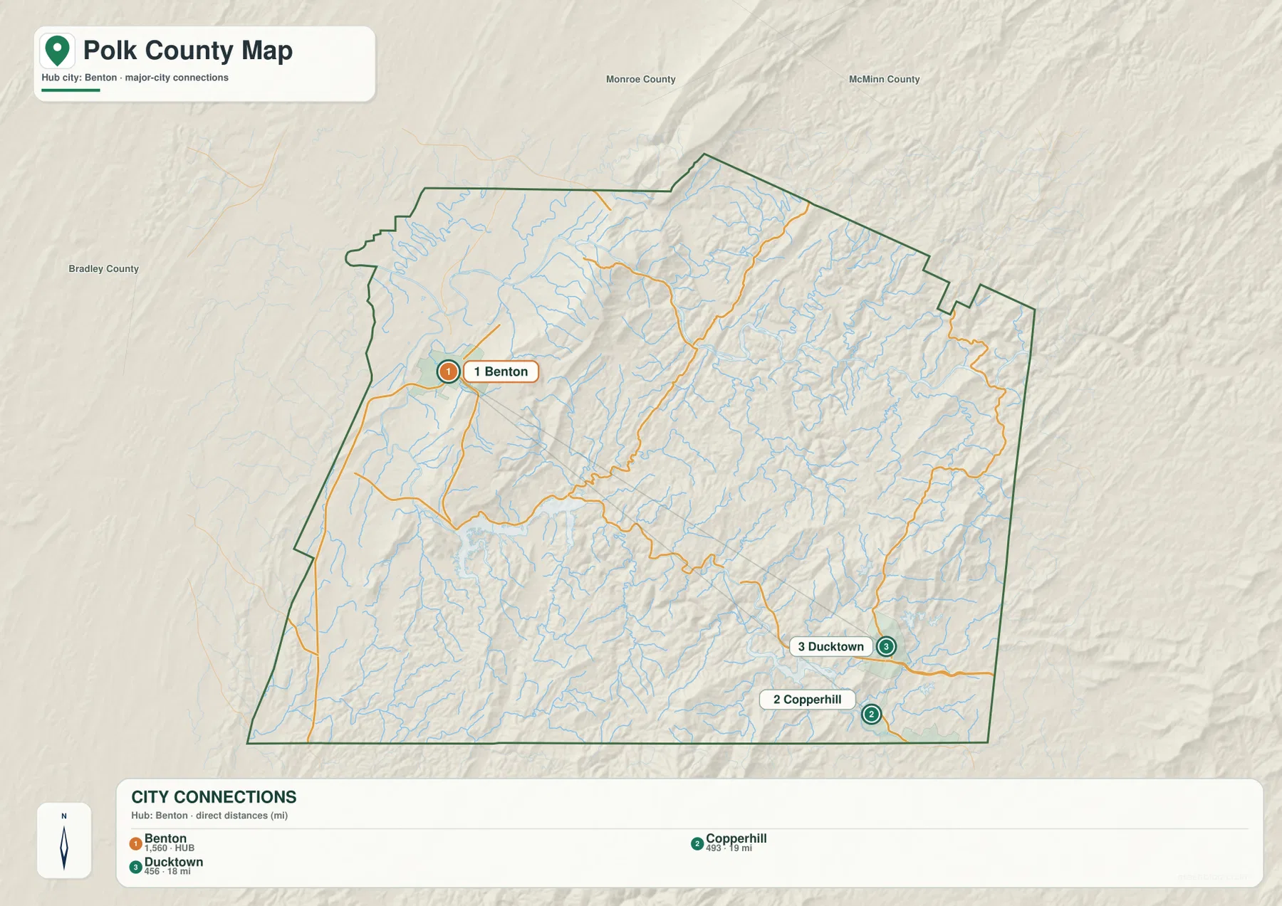
Bradley County is labeled west of Polk County, while Monroe and McMinn counties appear to the north and northwest. Polk County also reaches Tennessee’s southeastern edge, so the southern boundary meets another state in places. That setting helps explain why a route between Benton and Copperhill is not simply an east-west trip across a flat county. The road has to cross or follow major valleys inside a county that stretches through the southern Appalachian mountains.
Benton, Copperhill, and Ducktown occupy very different terrain
The city map ranks Benton first and labels its population as 1,560. Copperhill is second at 493, with a straight-line distance of about 19 miles from Benton, and Ducktown is third at 456, about 18 miles from the hub. Those distances are short enough to make the three places look like a compact group in a table, yet their landscape settings are sharply different.
Benton occupies the lower western side, where roads have more room to branch. Ducktown and Copperhill sit close together in the southeastern mountains, with SR 68 and the US 64–74 corridor providing the main county connections. High ridges and narrow stream valleys surround them, so the city pair feels much more separated from Benton than a straight-line distance alone suggests.
Other labels complete the picture without functioning as equally large centers. Delano marks the northern side, Ocoee the southwestern approach, and Farner the eastern boundary area. Together they show that Polk County is not organized around one circular urban area. The county seat is in the lower west, while smaller communities and the Ducktown–Copperhill pair occupy distinct mountain corridors farther east and south.
Hiwassee and Ocoee rivers cut two of the county’s largest valleys
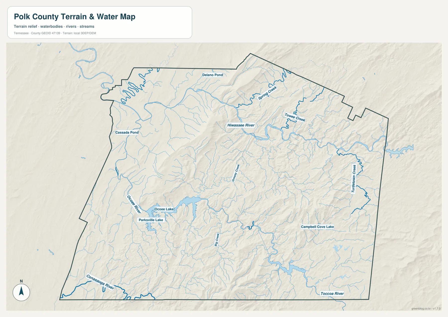
Hiwassee River is the dominant water feature across the north-central part of the county. It bends widely through a low corridor, receiving smaller mountain streams such as Spring Creek and Towee Creek. Delano Pond is marked near the northern side, while Cassada Pond provides another small water reference farther west. The river’s broad turns stand out clearly against the narrow tributaries coming down from the surrounding ridges.
Ocoee River enters the county from the southwest and passes through the Ocoee Lake and Parksville Lake area before continuing into a much narrower mountain valley. Big Creek and Greasy Creek descend from the interior, and the US 64–74 corridor follows the same general valley system for part of its route. Farther east, Tumbling Creek and Campbell Cove Lake occupy a separate drainage area between higher ridges.
The southern edge adds two more useful river references. Conasauga River follows part of the southwestern boundary, and Toccoa River is labeled near the southeast. These rivers do not dominate the center of the county in the same way as the Hiwassee and Ocoee, but they make the south-side drainage easier to place. Taken together, the water map shows a county divided into deep river and creek valleys rather than a broad plain with a few isolated streams.
Elevation rises from about 210 meters to more than 1,280 meters
The supplied elevation sheet lists an actual range of about 210 to 1,282 meters, with a mean near 419 meters. That is a very large vertical range for one county map. Much of the western side is dark green, indicating lower valleys and foothills, while yellow, tan, and brown terrain becomes increasingly common toward the central, eastern, and southeastern mountains.
Several high ridges stand well above the valleys. The north-central and southeastern mountain blocks contain some of the strongest relief, while Hiwassee River and Ocoee River form long low corridors between them. Benton and Ocoee lie in the lower western terrain. Ducktown and Copperhill are much closer to high mountain relief, and Farner is surrounded by deeply cut ridges on the east side.
This terrain difference helps explain the road map. The western side allows roads to spread more freely, but central and eastern routes are forced into river valleys and mountain gaps. The same straight-line distance can therefore represent very different travel conditions depending on which ridges and valleys lie between two points. The elevation map is intended for county-scale relief comparison, not survey-grade elevation at an individual property.

County facts that add context to the maps
- Official name: Polk County, Tennessee
- County seat: Benton
- FIPS code: 47139
- 2020 Census population: 17,544
- July 2025 population estimate: 18,592
- 2025 Gazetteer area: 434.6 square miles of land and 7.7 square miles of water
- Elevation shown on this map: about 210–1,282 m, mean about 419 m
The 2020 Census count and the July 2025 estimate are different types of population figures, so they should remain separate. The supplied data shows the 2025 estimate above the completed 2020 count. Countywide area and density measures also combine places with very different landscapes, including Benton, rural western valleys, reservoirs, and mountainous terrain around Ducktown, Copperhill, and the eastern boundary.
Polk County was established in 1839, and Benton serves as the county seat. That administrative role matches the modern map, where Benton is the clearest western road and place-name reference. The southeastern part of the county has a different settlement pattern around Ducktown and Copperhill, reinforcing the point that the county seat and the mountain communities occupy separate terrain zones.
Choose the map that matches the question
The county reference map is the best starting point when you need Benton, Ocoee, Delano, Farner, Ducktown, Copperhill, major roads, and the boundary on one page. It works well for location explanations and route orientation. The city sheet is cleaner when the goal is to compare Benton with the two ranked southeastern cities and understand their straight-line distances from the county seat.
Use the water map when Hiwassee River, Ocoee River, Ocoee Lake, Parksville Lake, and the mountain tributaries matter more than road detail. The elevation map is more useful for explaining why those rivers occupy long valleys and why the road system narrows through the central and eastern mountains. Placing the water and elevation sheets side by side gives the clearest view of the relationship between river corridors and high ridges.
The downloadable ZIP contains high-resolution JPG versions of all four maps and can be printed at A3 size while preserving the original proportions. Keep an untouched original if you plan to add arrows, routes, or notes to a copy. These are static reference maps, so current road closures, flood warnings, reservoir levels, legal parcel boundaries, or property ownership should be checked with the responsible agency.
Frequently Asked Questions
How far are Ducktown and Copperhill from Benton on the city map?
The city sheet shows Ducktown about 18 miles from Benton and Copperhill about 19 miles away in straight-line distance. Both are in the mountainous southeast, so road travel is shaped by ridges and river valleys and should not be inferred from straight-line distance alone.
Where are the Hiwassee and Ocoee rivers?
Hiwassee River makes broad bends across the northern and north-central part of Polk County. Ocoee River enters from the southwest, passes the Ocoee Lake and Parksville Lake area, and continues through a narrower mountain valley farther east. They form two of the clearest low corridors on the elevation map.
What is the strongest terrain contrast in Polk County?
The strongest contrast is between the low western valleys around Benton and Ocoee and the high mountains across the central, eastern, and southeastern portions. The supplied elevation map shows roughly 210 to 1,282 meters, with a mean near 419 meters.
Map File Information
The ZIP contains high-resolution JPG versions of the county, city, water, and elevation maps. They are suitable for A3 printing, presentations, classroom material, and general location reference.
- Included Files: county, city, water, and elevation JPGs
- File Type: JPG files in one ZIP
Related Maps
- Unicoi County Tennessee map | Erwin and Nolichucky Gorge
- Alamo to Gadsden: A Crockett County Tennessee Map
- Altamont, Monteagle, and Plateau Valleys — Grundy County Tennessee Map
Sources and references
- Tennessee State Library and Archives — Polk County fact sheet
- Tennessee Department of Transportation — Polk County road reference
- U.S. Census Bureau QuickFacts — Polk County, Tennessee
- U.S. Census Bureau TIGER/Line boundary data
- USGS National Hydrography
- USGS 3D Elevation Program
Green Map creates custom-edited map images using open geographic data sources such as geoBoundaries, Natural Earth, OpenStreetMap, and government open data. These maps are edited visual materials, not raw data files, and are provided for education, documents, presentations, and graphic reference.