You can download the Pickett County Map files on this page as one ZIP containing high-resolution JPG versions of the county, city, water, and elevation views for A3 printing, classroom work, presentations, or general reference. Byrdstown is the clearest settlement and road anchor, but the county changes character quickly away from town: broad reservoir water and lower valleys dominate the west, while the long eastern arm rises into higher ridges cut by narrow creeks.
The basic county view makes that contrast easier to see. Byrdstown sits in the western half near US 127 and several state routes, Travisville is farther east near the narrow middle section, and the county then stretches into a long elevated extension. Barnes appears to the west and Eastport near the southern projection. Rather than reading these as a flat list of labels, it is more useful to compare them with the county outline, nearby water, and the road directions that connect the separate pieces.
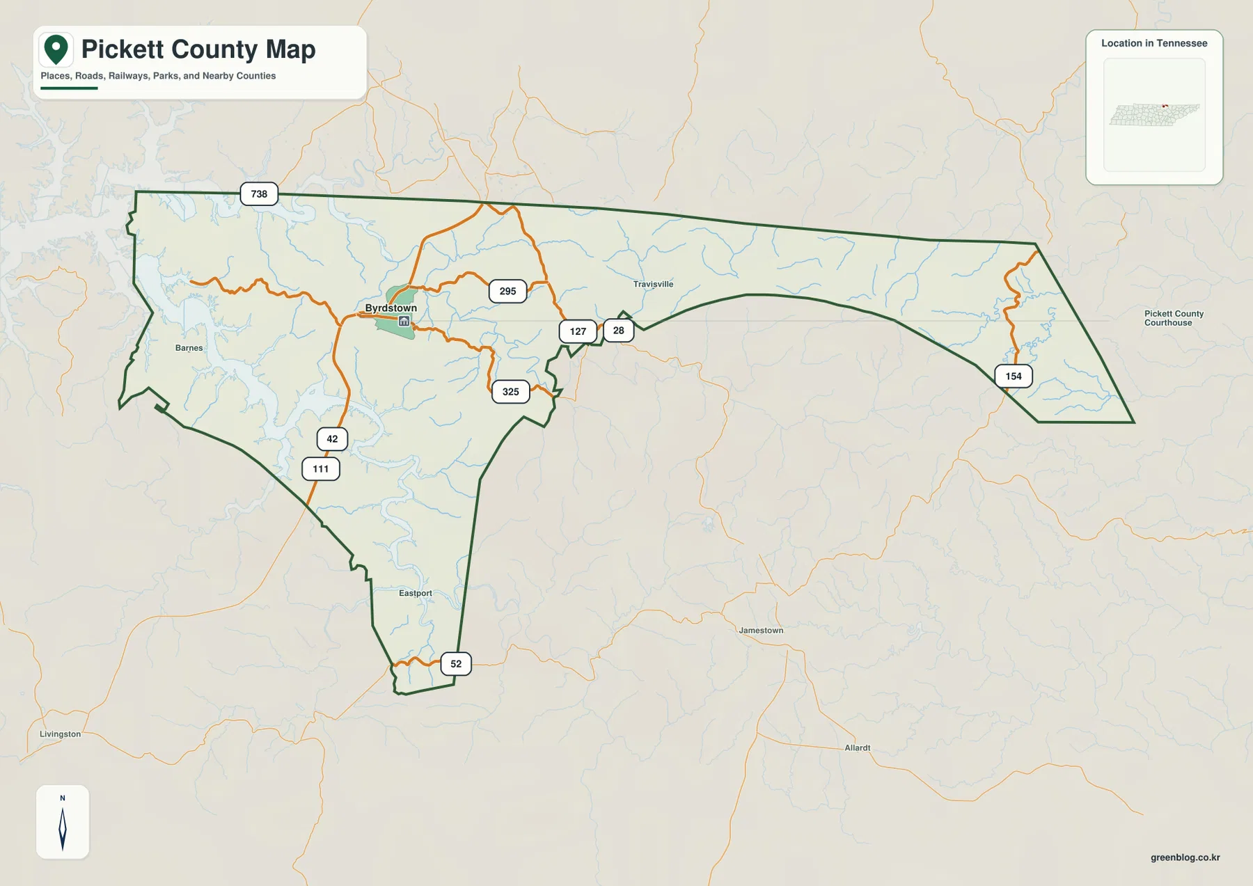
Table of Contents
Byrdstown is the main road and settlement reference
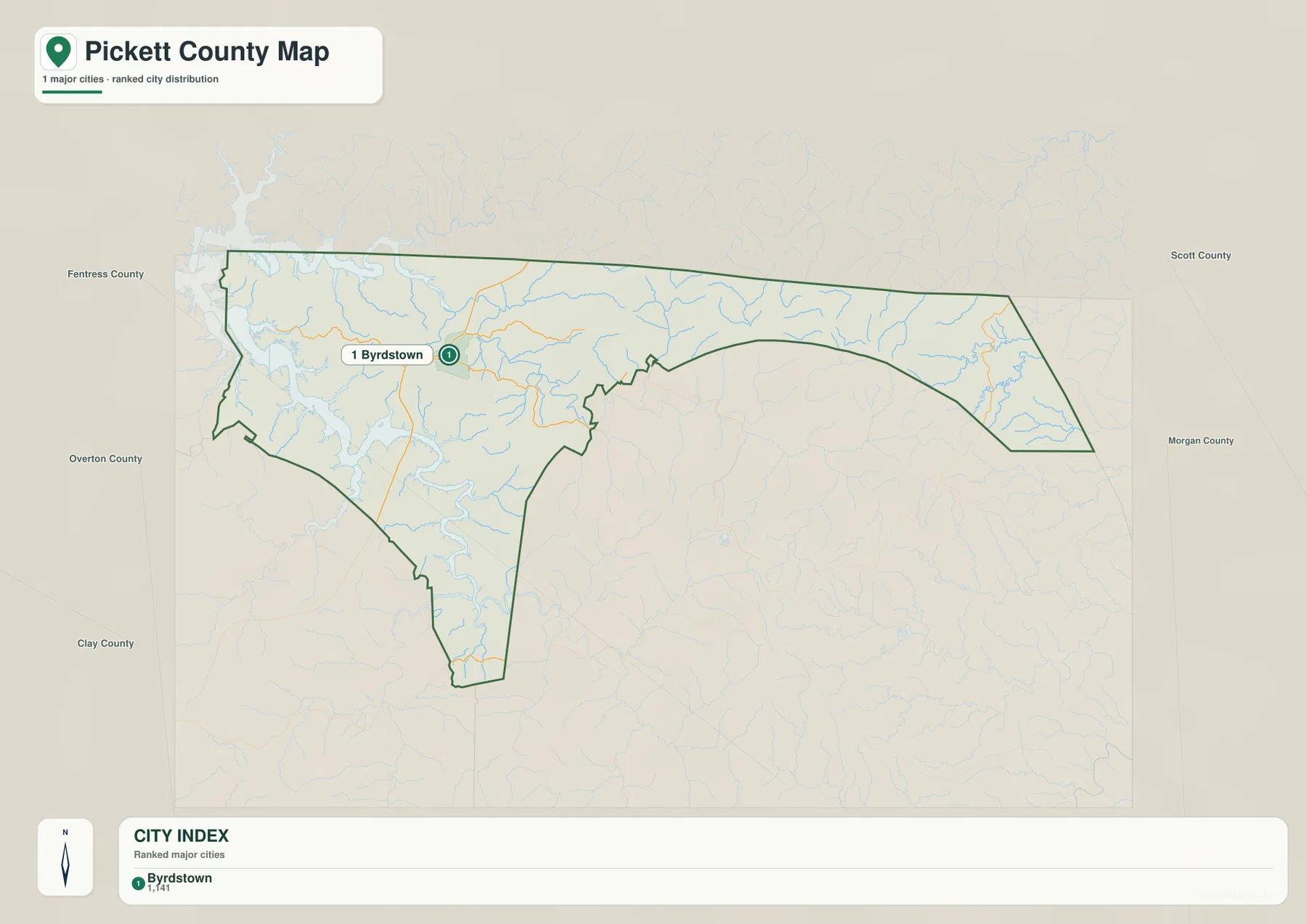
The ranked city sheet identifies only Byrdstown and labels its population as 1,141. That makes the map fundamentally different from one with several competing urban centers. Byrdstown is the county seat and is the logical place to begin orientation because US 127 and SR 295 are easy to trace from the area, while SR 42 and SR 111 continue toward the south and southwest. SR 325 provides a shorter connection near the center, and SR 154 becomes a strong reference in the elongated eastern section.
Pickett County has an unusual shape. A broad western body narrows near the center, then expands into a long eastward arm. A separate southern projection descends below the main western section. The road network follows that geometry rather than crossing the county in one simple grid. As the map moves east of Byrdstown, routes enter more broken terrain, and the relationship between road bends, creek valleys, and ridges becomes increasingly important.
Travisville is marked near the constricted middle of the county and is a useful point for separating the Byrdstown side from the eastern ridge country. Barnes provides a western reference, while Eastport helps identify the southern extension. These labels are especially useful when the map is being annotated for a presentation or class exercise because they let the reader describe direction without filling the page with many minor place names.
The city map shows one dominant county center
Byrdstown is the only ranked major city on the city sheet, so the important pattern is not a hierarchy of towns. The useful question is how Byrdstown sits inside a county that extends much farther east than the main settlement. The surrounding map also labels Fentress County, Overton County, Clay County, Scott County, and Morgan County as regional references. Those names help show the direction of surrounding territory without implying that every labeled county shares the same type of boundary relationship.
The city point lies in the lower and less rugged western half, while the long eastern arm contains no comparable ranked city marker. This matters because a reader could otherwise assume that the visually empty east is simply unused space. The water and elevation sheets show the opposite: it is filled with ridges, small tributaries, and narrow valleys. Byrdstown therefore works best as an administrative and transportation anchor rather than as a summary of all terrain in the county.
Obey River, Wolf River, and reservoir water define the west
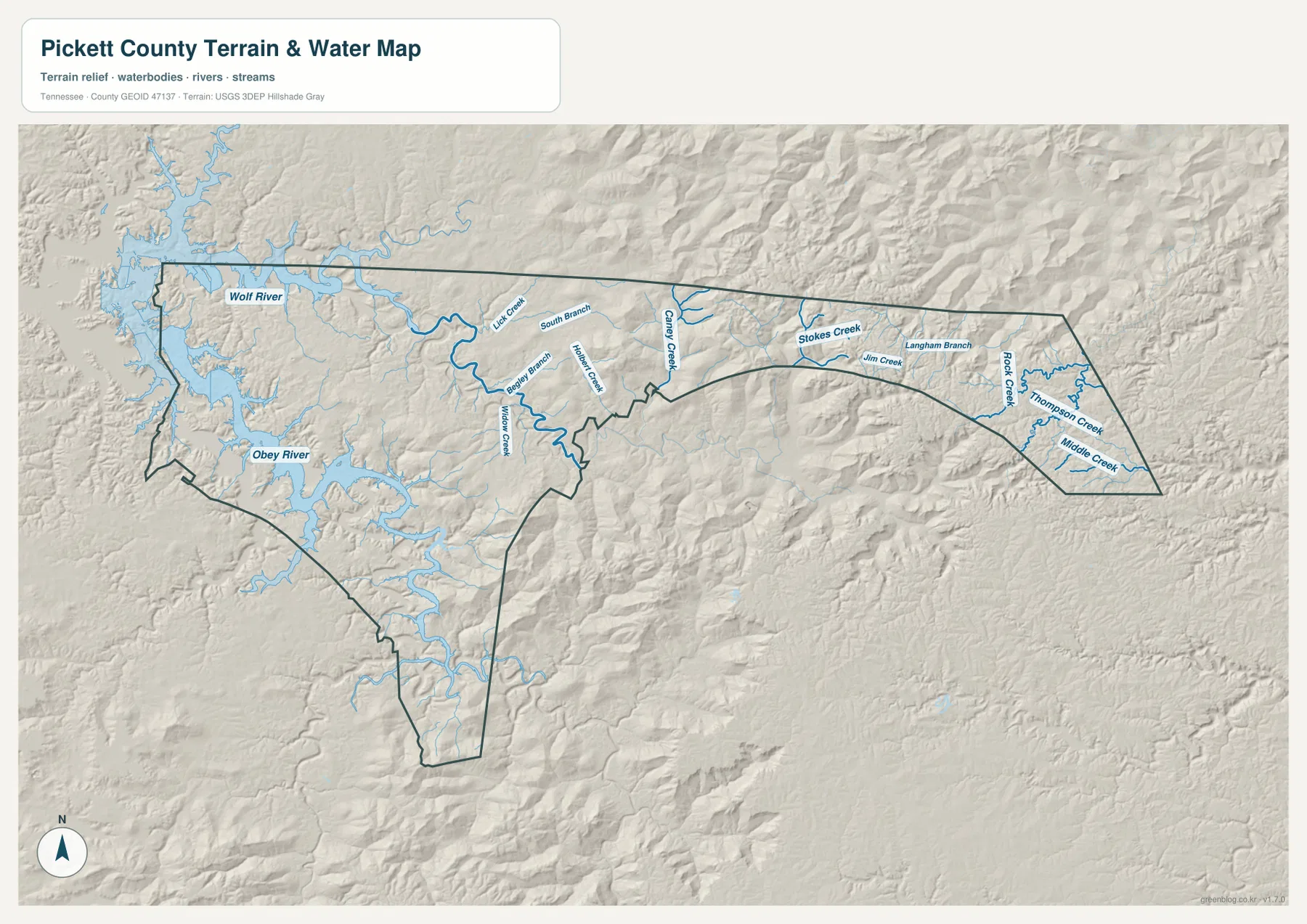
The western water pattern is the strongest visual feature on the terrain-and-water map. Wolf River connects with broad reservoir water in the northwest, while Obey River occupies the southwest and west-central valleys. The original county title’s reference to Dale Hollow Lake is useful here because the large reservoir surface around the western side gives the county a very different appearance from the ridge-dominated east.
Smaller tributaries bridge the transition between those major western waters and the narrow center of the county. Lick Creek and South Branch follow northern valleys, while Beaty Branch and Miller Creek cross the central hills. Willow Creek bends toward the Obey River system farther south, and Caney Creek provides a useful drainage reference close to the narrowing middle section. Together they show that the western half is not a single open lowland; it is a set of valleys descending toward larger river and reservoir channels.
The eastern arm has a different drainage texture. Stokes Creek and Jim Creek occupy valleys in the northern and central part of the extension, with Langham Branch between them. Rock Creek becomes the most obvious named channel farther east, while Thompson Creek and Middle Creek cut smaller valleys toward the southeastern side. These creeks are narrower than the western reservoir water and are tightly confined by relief, which becomes obvious when the water sheet is compared with the elevation map.
Elevation climbs from roughly 196 to 544 meters
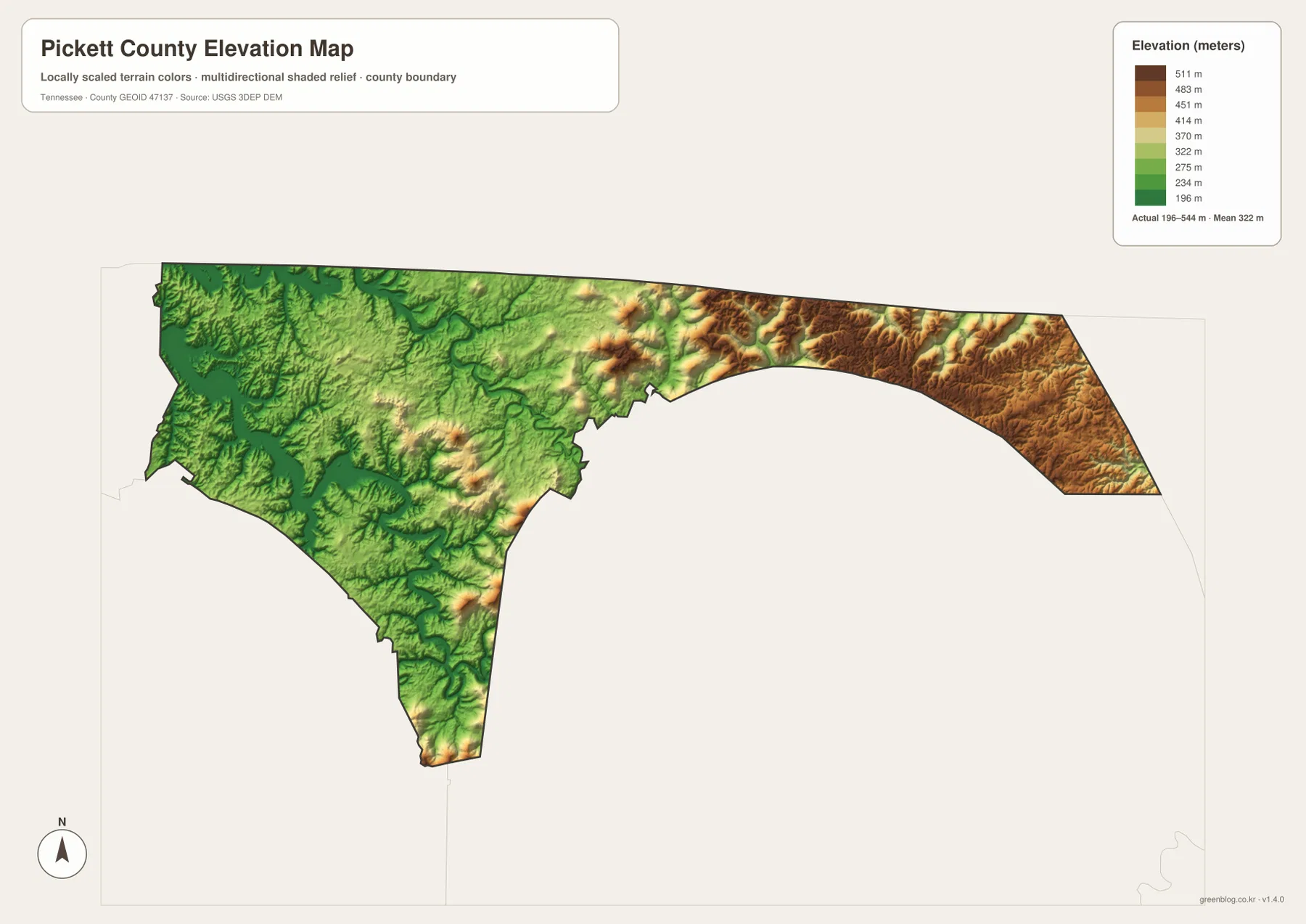
The supplied elevation sheet lists an actual range of about 196 to 544 meters and a mean near 322 meters. The west and southwest contain the broadest green areas, which line up with the Obey and Wolf River valleys and the reservoir edge. Byrdstown is also in terrain that is generally lower than the far eastern end, helping explain why the county’s main town and road junction are concentrated on the western side.
Relief increases sharply after the county narrows east of the central section. Yellow, tan, and brown colors become more common, and the eastern end is dominated by high ridges. Stokes Creek, Rock Creek, Thompson Creek, and Middle Creek occupy lower cuts between those ridges. The difference is strong enough that a short straight-line distance on the map may cross several steep slopes and valleys.
The southern projection also contains alternating ridges and valleys, but the broadest high ground remains in the east. For practical map reading, the most useful comparison is the low western water landscape, the middle-elevation Byrdstown area, and the high eastern ridge country. That sequence explains the county more clearly than focusing on a single maximum or minimum elevation value.
County facts that add context to the maps
- Official name: Pickett County, Tennessee
- County seat: Byrdstown
- FIPS code: 47137
- 2020 Census population: 5,001
- July 2025 population estimate: 5,219
- 2025 Gazetteer area: 163.0 sq mi land and 11.5 sq mi water
- Elevation shown on this map: about 196–544 m, mean about 322 m
The population and area values above come from the Census-based material already included in the source package. The 2020 value is a completed census count, while the 2025 figure is an estimate, so they should remain clearly labeled as different statistical products. The land and water figures are also countywide totals. They help establish scale but do not describe how difficult a particular road, river crossing, or ridge may be.
Tennessee State Library and Archives material in the supplied reference set identifies Pickett County as having been established in 1879 and Byrdstown as the county seat. On the modern maps, that administrative role matches the concentration of roads in the Byrdstown area. The historical fact is therefore most useful as context for why Byrdstown remains the logical starting point for county orientation.
Choose the map that fits the question
The county reference map is the best starting point when you need Byrdstown, the county outline, US 127, SR 154, SR 295, SR 325, and outer place references on one sheet. It works well for general county orientation or presentations where travel direction matters. The city sheet is cleaner when the goal is simply to show Byrdstown as the county’s primary urban and administrative reference.
The water map is more useful for following Wolf River, Obey River, Lick Creek, Caney Creek, Stokes Creek, and Rock Creek without the road layer dominating the page. When terrain height matters, the elevation sheet makes the western lowlands and high eastern ridges immediately visible. Using the water and elevation maps side by side gives the clearest explanation of why eastern creeks occupy tight valleys and why the landscape changes so dramatically away from Byrdstown.
The downloadable JPGs preserve the map layouts at high resolution and can be printed at A3 size. Keep the original aspect ratio when printing, and make notes on a copy if arrows, routes, or labels need to be added. These are static reference maps, not live products for road closures, legal property boundaries, flood warnings, reservoir levels, or boating conditions, so time-sensitive decisions should be checked with the responsible agency.
Frequently Asked Questions
Where is Byrdstown on the Pickett County Map?
Byrdstown is in the western half of the county near US 127 and SR 295. It is the county seat and the only ranked major city on the city sheet, so it is the easiest starting point for understanding roads, nearby water, and the long eastern extension.
Where are Dale Hollow Lake and the Obey River relative to the county?
The broad reservoir water and the Obey River system are concentrated along the western and southwestern side. Wolf River also connects with water in the northwest. These western waters contrast strongly with the narrow creek valleys and high ridges that dominate the eastern extension.
What is the main elevation contrast across Pickett County?
The strongest contrast is between lower western river and reservoir valleys and the high ridges in the far eastern arm. The supplied elevation map shows about 196 to 544 meters, with a mean near 322 meters. Eastern creeks such as Stokes Creek and Rock Creek occupy lower cuts between those higher ridges.
Map File Information
The ZIP contains high-resolution JPG versions of the county, city, water, and elevation maps. They are suitable for A3 printing, presentations, classroom material, and general location reference.
- Included Files: county, city, water, and elevation JPGs
- File Type: JPG files in one ZIP
Related Maps
Sources and references
- Tennessee State Library and Archives — Pickett County fact sheet
- Tennessee Department of Transportation — Pickett County road reference
- U.S. Census Bureau QuickFacts — Pickett County, Tennessee
- U.S. Census Bureau Gazetteer Files
- USGS National Hydrography
- USGS 3D Elevation Program
Green Map creates custom-edited map images using open geographic data sources such as geoBoundaries, Natural Earth, OpenStreetMap, and government open data. These maps are edited visual materials, not raw data files, and are provided for education, documents, presentations, and graphic reference.