Scott County lies in western Kansas, where Scott City is the clear settlement and service center within a broad High Plains landscape. K-96 crosses the county through the city, US 83 provides the main north–south reference, and K-95 leads toward the deeply cut Lake Scott country to the north. Unlike counties with several ranked towns, the supplied city panel identifies only Scott City as a major city, making the surrounding terrain and drainage especially important for understanding the county. High-resolution map files are available for download in the section below.
This guide follows Scott City, the county road network, Lake Scott, Ladder Creek, White Woman Creek, Dry Lake, and an elevation range of about 822 to 968 meters. WebP previews are available for quick viewing, and the matching high-resolution JPG files can be downloaded together in one ZIP for printing, classroom work, or offline reference.
Table of Contents
Scott City is the county’s single dominant road and service center
Scott City sits near the middle of the county, with K-96 crossing east to west and US 83 providing the primary north–south route. K-95 continues north toward the Lake Scott area, while a wide grid of county roads spreads across the surrounding agricultural landscape.
The Kansas Historical Society identifies Scott City as the county seat. Scott County was established in 1873 and organized in 1886, and it was named for General Winfield Scott. On the general map, the hospital, denser street network, and road connections are all concentrated around Scott City.
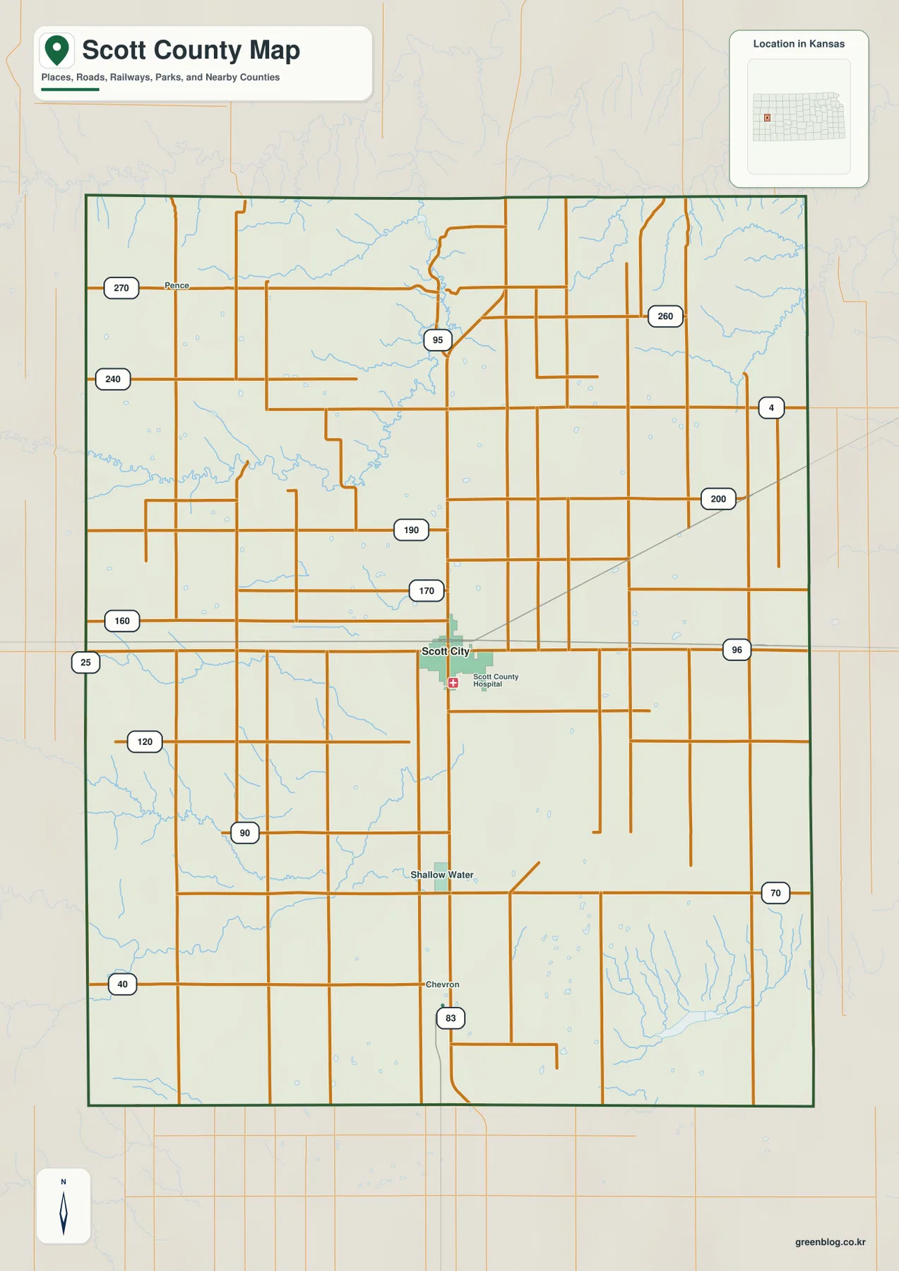
Shallow Water appears south of Scott City, and the US 83 corridor continues toward the southern county. The northern and western sides contain much wider road spacing and more deeply cut stream terrain, creating a sharp contrast with the compact city center.
Scott City is the only ranked major city on the supplied city map
The city panel shows one ranked major city: Scott City, with an index value of 3,800. This is a map index rather than a current official population estimate, and it should not be presented as a census count.
Kansas Historical Society census data lists Scott City at 4,113 residents in 2020, within a county total of 5,151. The official census figures and the map index are different datasets, but both illustrate how strongly county settlement is concentrated in Scott City.
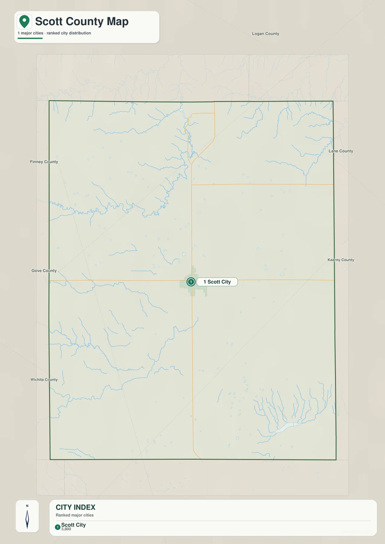
Because there are no additional ranked cities to compare on this panel, the more useful county-wide comparison is between Scott City and the surrounding High Plains: the northern Lake Scott canyon, western uplands, southern creek country, and lower southeastern terrain.
Lake Scott and Ladder Creek cut a deep northern valley into the High Plains
The northern water map is dominated by Lake Scott and Ladder Creek. Ladder Creek enters from the west, bends through a deeply incised valley, and connects with the Lake Scott area. The surrounding tributaries carve into otherwise broad uplands, creating one of the strongest terrain contrasts in the county.
Kansas Department of Wildlife and Parks places Historic Lake Scott State Park about 11 miles north of Scott City, west of US 83 on K-95. The 1,020-acre park surrounds a roughly 100-acre spring-fed fishing lake and protects natural springs, wooded canyons, rocky bluffs, and prairie terrain.
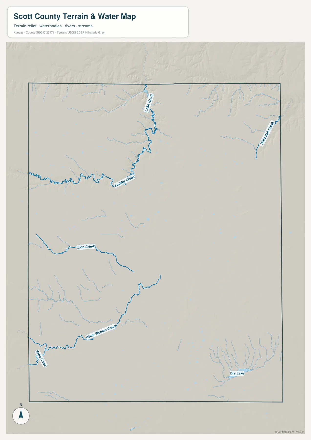
West Salt Creek forms a separate northeastern drainage, while Lion Creek crosses the central-southwestern portion of the county. Farther south, White Woman Creek and Beaver Creek cut long valleys through open High Plains terrain.
Dry Lake occupies a lower area in the southeast with many short tributaries converging around it. The name should not be read as proof of a permanent open-water lake; moisture and surface-water conditions can vary. This map is for geographic reference and is not a flood, water-quality, parcel, or access map.
Elevation from 822 to 968 meters drops strongly from west to east
The elevation surface ranges from about 822 to 968 meters, with a mean near 913 meters. Brown and tan high ground dominates much of the western half, while green lower terrain becomes more extensive toward the east and southeast. The county shows a clear west-to-east decline of more than 140 meters.
In the northwest, Ladder Creek and its tributaries cut sharply into elevated High Plains terrain. Lake Scott lies in a distinctly lower corridor than the surrounding uplands, helping explain why the state park feels like a canyon oasis within western Kansas prairie.
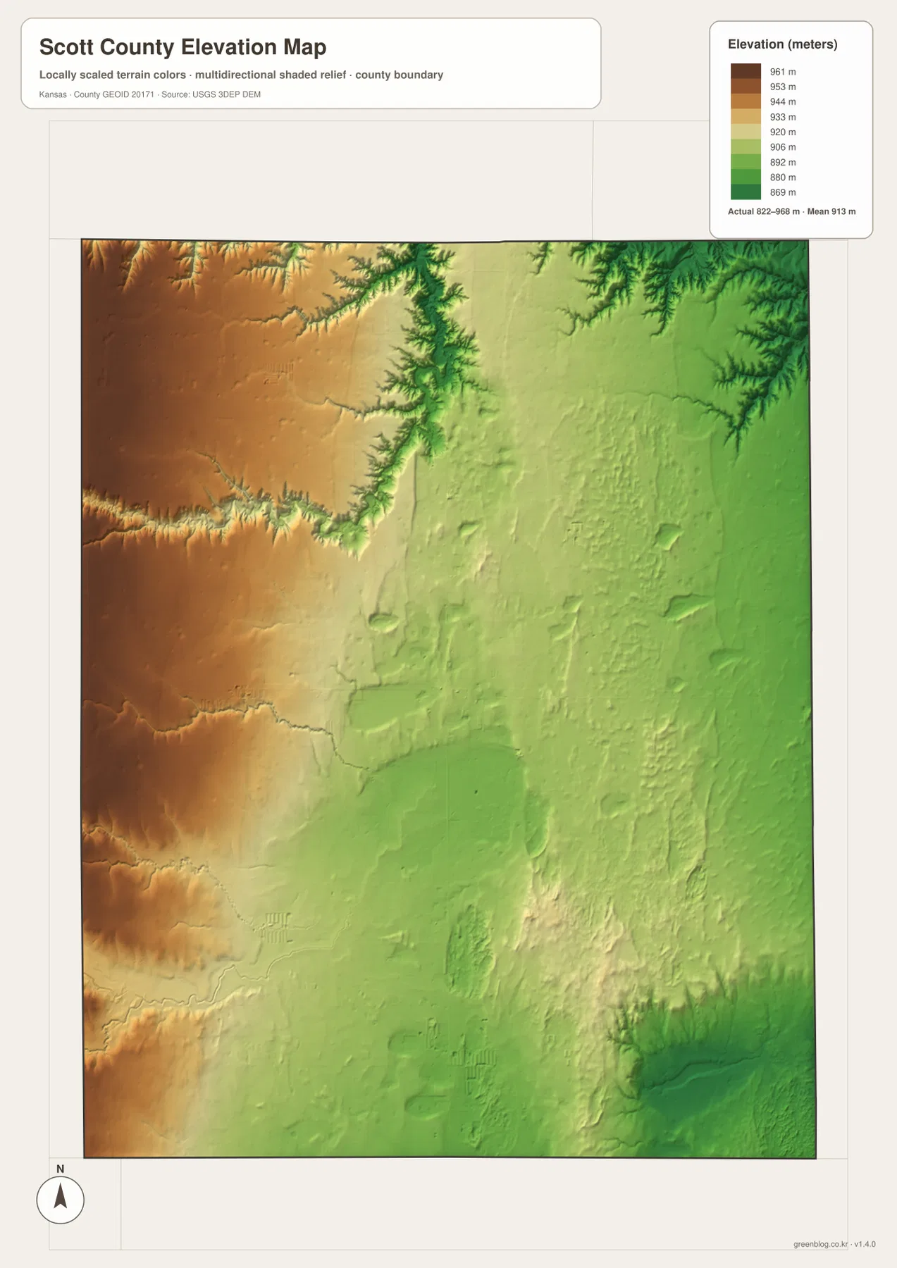
Scott City occupies an intermediate elevation zone between the highest western uplands and the lowest eastern terrain. White Woman Creek and Beaver Creek form narrow lower corridors in the southwest, while the Dry Lake area creates a broader depression in the southeast.
The Kansas Historical Society classifies Scott County within the High Plains physiographic region. The map supports that description while also showing how deeply individual creek valleys can cut into the plateau. The elevation surface is generalized and should not be used for parcel surveying, construction grades, drainage design, or legal boundary work.
Historic Lake Scott State Park also protects the El Cuartelejo archaeological site
Historic Lake Scott State Park is important for more than scenery. The Kansas Historical Society and Kansas Department of Wildlife and Parks identify El Cuartelejo within the park, where archaeological remains include a seven-room pueblo associated with the Plains Apache and Pueblo peoples.
El Cuartelejo is a National Historic Landmark and is considered the northeasternmost known pueblo site in the United States. More than 20 archaeological sites have been documented in and around the park, giving the Lake Scott valley unusual historical depth as well as distinctive geology.
Battle Canyon adds another historic layer south of Lake Scott
The Kansas Historical Society records the 1878 Battle of Punished Woman’s Fork in Scott County. Kansas Department of Wildlife and Parks places Battle Canyon about one mile south of Historic Lake Scott State Park and connects the site with the last U.S. Army officer killed in combat with Native Americans in Kansas.
The general county map does not show battlefield-scale detail, but the steep canyon terrain around Lake Scott helps explain why this northern part of the county played such a notable role in regional travel and conflict. Visitors should use official markers and current park guidance when locating historic areas.
The trip from Scott City to Lake Scott reveals the county’s strongest terrain change
Heading north from Scott City toward K-95 begins across relatively open High Plains and gradually enters the deeply cut Ladder Creek valley. The change looks modest on the road map but becomes much more obvious when the water and elevation views are compared.
Traveling southeast from Scott City shows a different transition. Elevation generally decreases toward Dry Lake and the lower eastern side, while heading west leads into broader high ground. Using Scott City as the central reference therefore makes the county’s overall west-to-east relief pattern easy to understand.
For posters, classroom prints, or presentation slides, use the original JPG files in the download archive rather than enlarging the web previews. Small road labels, creek names, community text, and the elevation legend remain clearer at the higher resolution.
Frequently Asked Questions
Why does the city map show only Scott City?
The supplied city panel includes one ranked major city, Scott City, with an index value of 3,800. That figure is a map index rather than an official population count and reflects how strongly settlement is concentrated around the county seat.
Where is Lake Scott in relation to Scott City?
Historic Lake Scott State Park and Lake Scott are north of Scott City. Kansas Department of Wildlife and Parks places the park about 11 miles north of town, west of US 83 on K-95.
Can the 822–968 meter elevation image be used for surveying?
No. It is a generalized county-scale terrain image for comparing high western High Plains terrain with lower creek valleys and the Dry Lake area. Parcel elevations, engineering grades, drainage design, and legal boundary work require more precise official data and, where needed, professional surveying.
Map File Information
The archive contains the Scott County, Kansas general county map, city map, terrain-and-water map, and elevation map as original high-resolution JPG files.
- Included Files: Use only the versions confirmed in the article and supplied images
- File Type: Use the confirmed download contents
- Intended Use: Printing, education, presentations, and map-based projects
Related Maps
Sources and references
- Kansas Historical Society: Scott County, Kansas — county seat, High Plains setting, El Cuartelejo, and county history
- Kansas Department of Wildlife and Parks: Historic Lake Scott State Park — Lake Scott, canyon terrain, park location, and recreation information
- Kansas Historical Society: El Cuartelejo, Scott County — Plains Apache and Pueblo archaeological history
- U.S. Census Bureau TIGER/Line Shapefiles — county boundary and geographic reference data
- USGS National Hydrography — river and stream reference data
- USGS 3D Elevation Program — elevation and terrain reference data
Green Map creates custom-edited map images using open geographic data sources such as geoBoundaries, Natural Earth, OpenStreetMap, and government open data. These maps are edited visual materials, not raw data files, and are provided for education, documents, presentations, and graphic reference.