Download the four high-resolution JPG maps for Knox County, Illinois, directly from this page in one ZIP file. The set is built around the county’s most useful geographic contrasts: Galesburg and East Galesburg form the strongest west-central settlement focus, Knoxville sits to the southeast, Wataga and Oneida mark the northern interior, and Abingdon lies well to the south. The maps also show the county boundary and numbered roads, named streams and lakes, and the 158–269 meter elevation pattern that becomes lower and more dissected toward the Spoon River valleys in the southeast.
Two geographic patterns stand out before any individual map is studied in detail. First, roads and facility symbols cluster around Galesburg while towns become more widely spaced toward the north, east, and south. Second, the terrain becomes increasingly defined by creek valleys that converge toward the lower southeastern part of the county. The water map emphasizes Walnut Creek, Court Creek, Haw Creek, and the Spoon River system, while the elevation image shows why those drainage lines appear as lower corridors between higher pieces of ground.
The four supplied maps are not alternate color versions of the same product. The general county map combines roads, towns, boundaries, streams, and selected facilities. The city-distribution map reduces the clutter and highlights Galesburg, Abingdon, Knoxville, Oneida, East Galesburg, and Wataga. The terrain-and-water map gives named rivers, creeks, and lakes more prominence, and the elevation map summarizes an actual county range of about 158–269 meters with a mean near 219 meters. Used together, they connect settlement patterns with the drainage and relief that are harder to see on a road map alone.
Table of Contents
Roads radiating from Galesburg toward Knoxville and the northern towns
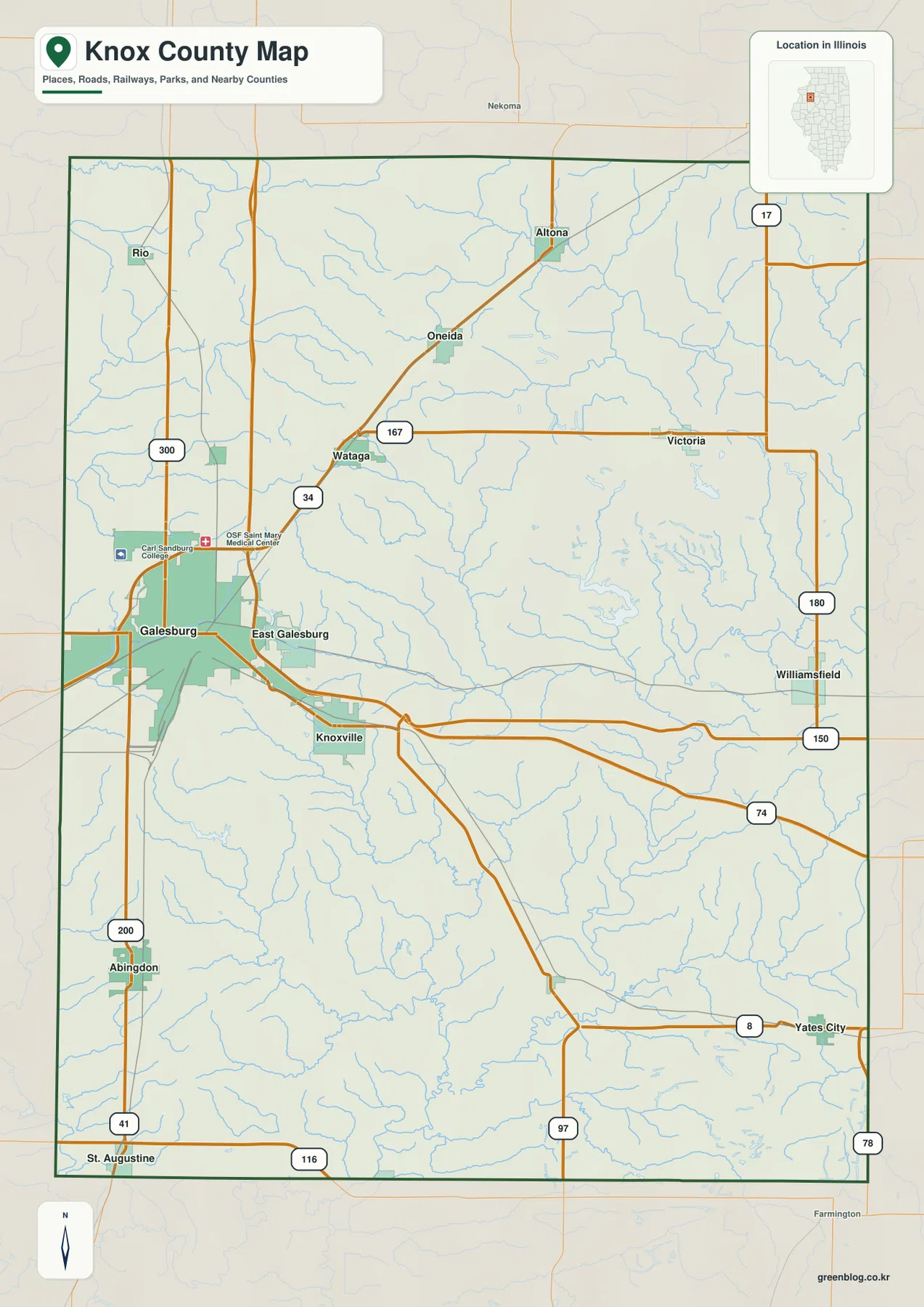
The densest part of the general map is the Galesburg–East Galesburg area. Galesburg lies near the western side of the county rather than at its geometric center, and East Galesburg sits immediately to the east. Knoxville is separated from them to the southeast, making those three places useful anchors for reading the west-central portion of the map. Symbols for Carl Sandburg College and OSF Saint Mary Medical Center also appear around Galesburg, reinforcing how much more concentrated the mapped roads and facilities are there than in the outer parts of the county.
North of Galesburg, Wataga is close to the US 34 label, with Oneida and then Altona farther to the northeast. Route 17 is shown near Altona, and the road marked 167 runs eastward from the Wataga area toward Victoria. Rio appears in the northwest, while the road marked 300 provides another reference on the western side. These towns do not form one continuous built-up strip; they are separated by broad areas crossed by local roads and a dense network of small streams.
The eastern side has its own chain of reference points. Victoria is in the northeast interior, Williamsfield is farther south along the eastern side, and Yates City sits in the southeast. The road marked 150 creates a strong east-west reference from the Knoxville area toward the eastern county, while Route 8 passes near Yates City. Road labels 180 and 74 help orient the eastern and southeastern edges. These numbered corridors are useful for establishing direction, but the map is not a live traffic product and should not be used to determine closures or current driving conditions.
Southwest of Galesburg, Abingdon is one of the clearest settlement markers, with St. Augustine near the southern boundary. Routes 41 and 200 run along the western side and make the north-south separation easy to see. The large spaces between towns in the south and east should not be read as empty terrain. Streams, small roads, and scattered settlements continue across those areas even though the symbols are less concentrated than they are around Galesburg.
This general map is best for county-scale orientation. It answers questions such as where Knoxville lies relative to Galesburg, how Wataga connects to the northern towns, or which side of the county contains Yates City. It is not intended to define property lines, settle a legal boundary question, or replace turn-by-turn navigation. For those tasks, current authoritative records and purpose-built mapping services are more appropriate.
Six mapped communities reveal a strong west-central population focus
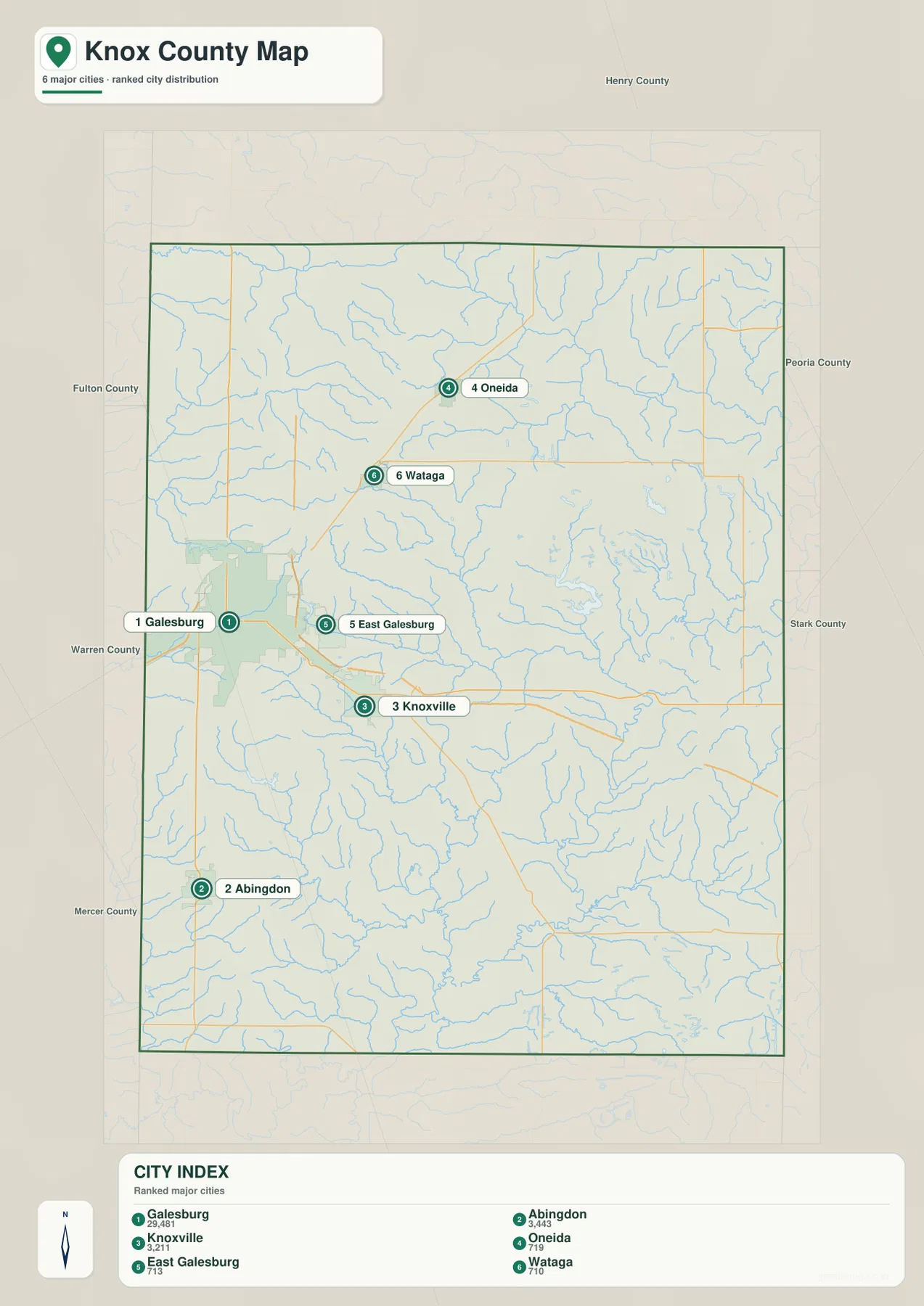
The city-distribution map removes most secondary information and makes the settlement pattern much easier to compare. Galesburg is marker 1 in the west-central portion of the county, and East Galesburg is marker 5 immediately to its east. Knoxville, marker 3, is farther southeast. Abingdon, marker 2, stands well to the southwest, while Wataga and Oneida form the northern pair. Once these six locations are familiar, moving between the road, water, and elevation maps becomes much easier.
The CITY INDEX printed on the map lists Galesburg at 29,481, followed by Abingdon at 3,443 and Knoxville at 3,211. Oneida is shown at 719, East Galesburg at 713, and Wataga at 710. These figures are best treated as the reference values embedded in the supplied map rather than as a substitute for a current official population release. Their most useful message here is comparative: Galesburg is displayed as much larger than the other five labeled communities.
The separation among the smaller places is as informative as the ranking. Abingdon is far south of the Galesburg cluster, Knoxville is offset to the southeast, and Wataga and Oneida occupy the north. That means the county’s settlement pattern is not a uniform grid of similarly sized towns. It is closer to a dominant west-central city with smaller communities distributed along roads in several directions. The city map makes that pattern visible without the stream names and facility symbols that fill the general map.
Neighboring county labels around the outside provide regional orientation. Henry County appears to the north, Peoria and Stark counties are shown to the east, and Warren and Mercer counties appear along the western and southwestern sides. Fulton County is also labeled on the western side of the wider frame. Those names are context markers, not a substitute for a legal boundary survey, but they help show how close the Galesburg side of Knox County is to its western neighbors.
The ranked-city map does not calculate driving distance or travel time. The spacing of the markers is a map-position comparison, so a trip between two towns may follow a road path that is longer than the apparent gap between symbols. Use this map when a presentation or lesson needs a clean view of the principal mapped communities, then switch to the general map when numbered roads and actual route context matter.
From Walnut Creek and Court Creek to the Spoon River drainage
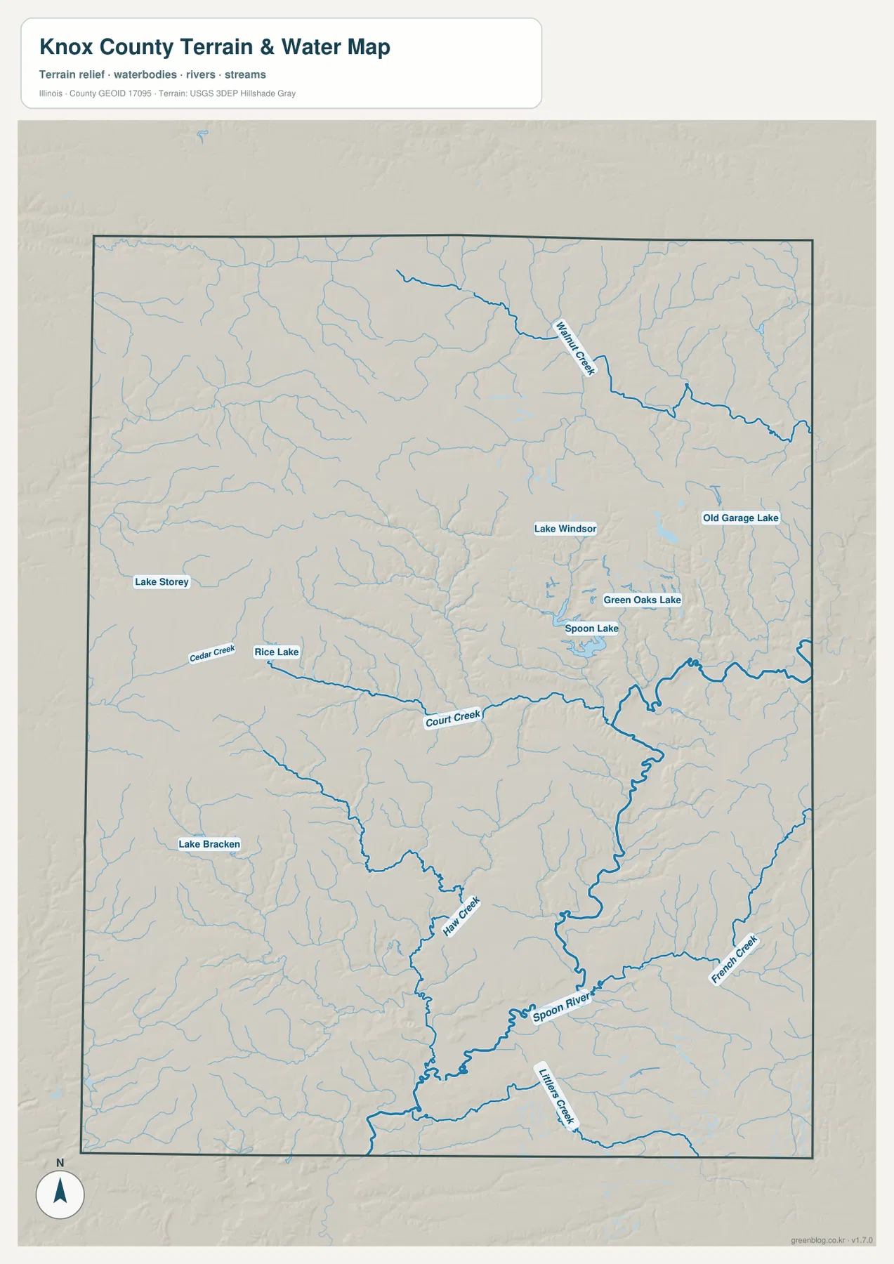
The terrain-and-water map shifts attention away from highways and toward drainage. Walnut Creek is the most prominent labeled stream in the northeast. Court Creek crosses the central portion, while Haw Creek winds through the south-central interior. The Spoon River becomes the dominant named watercourse in the southeastern part of the map. Numerous smaller tributaries feed these channels, so the county reads as a finely dissected landscape rather than a featureless plain.
Several named lakes provide additional landmarks. Lake Storey appears toward the west-central side, and Rice Lake sits farther south and east near Cedar Creek. Lake Windsor, Green Oaks Lake, and Spoon Lake are grouped in the central-eastern area, while Old Garage Lake is farther northeast. Lake Bracken appears in the southwest. The map does not imply that these water bodies have the same size or purpose; it simply makes their locations easier to compare with nearby streams and terrain.
Court Creek and Haw Creek become especially useful when the water and elevation maps are viewed side by side. Their channels follow lower corridors between higher pieces of ground, and the southeastern Spoon River valley expands into the broadest low-elevation zone. The northern half, by contrast, contains more extensive high ground broken by narrow tributary cuts. That relationship between creek valleys and uplands is one of the clearest county-specific patterns in the supplied map set.
This is a general hydrography reference, not a flood map, wetland determination, navigation chart, or water-quality product. A named creek can change in appearance with season and flow conditions, and small channels may be generalized at county scale. Anyone making a flood, land-use, or engineering decision should use the current official source designed for that purpose rather than infer a regulatory boundary from this image.
A practical way to read the water map is to begin with the Spoon River in the southeast, trace Haw Creek and Court Creek back toward the interior, and then move north to Walnut Creek. After that, the named lakes on the western and central-eastern sides become easier to place. Returning to the general map at the same locations shows how the waterways relate to Galesburg, Knoxville, Wataga, and the outer road network.
A 158–269 meter surface shaped by higher northern ground and lower southeastern valleys
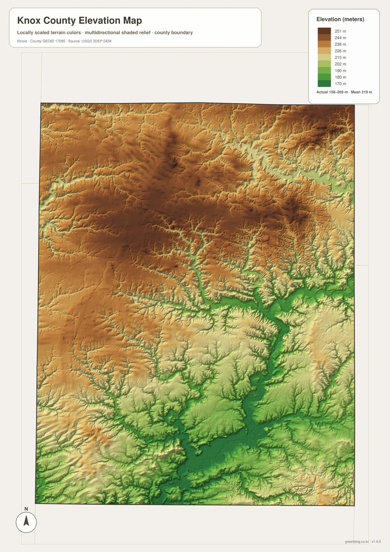
The elevation legend reports an actual range of roughly 158 to 269 meters and a mean near 219 meters. Broad brown and tan areas dominate much of the north and northwest, while greener low areas become more extensive toward the southeast. The county does not simply tilt downward in one direction, however. Narrow low corridors branch through the center where creeks have cut into the higher surface, leaving a complex pattern of uplands separated by valleys.
The Spoon River corridor is the clearest low-elevation feature in the southeastern part of the image. Once the river is located on the water map, the corresponding green zone on the elevation map is easy to follow. Haw Creek and Court Creek also produce narrow lower pathways that extend back toward the interior. This is why the southeastern quarter looks more strongly dissected on the relief image than it does on the road map.
Northern Knox County shows larger connected areas of higher ground. After finding Wataga, Oneida, and Altona on the settlement maps, their general surroundings can be matched to the tan and brown terrain farther north. Around the Galesburg side, the relief is more mixed, with higher surfaces interrupted by local drainage. The most accurate summary is therefore not that the county contains a single ridge, but that broad uplands have been cut into by many stream valleys.
This elevation surface is designed for county-scale comparison, not survey-grade measurement. The 158–269 meter range can describe broad relief, but it should not be used to set a building grade, determine the exact elevation of a parcel, design drainage, or make engineering decisions. Detailed work should rely on the original USGS elevation data, project-specific measurements, and professional surveying where required.
The easiest reading order is water first, elevation second. Find the Spoon River, Court Creek, and Haw Creek on the hydrography map, then look for the matching green corridors on the relief surface. Compare those valleys with the higher northern terrain before returning to the general map to locate Galesburg, Knoxville, and the northern towns. That sequence gives the elevation colors concrete geographic meaning instead of treating them as an abstract gradient.
Start with Galesburg, then connect the roads to water and relief
For a first orientation, start with the general county map. Find Galesburg and East Galesburg, then locate Knoxville, Wataga, and Abingdon around them. Numbered roads such as 34, 41, 150, 17, and 8 provide fixed references for the north, east, and south. Once those points are familiar, the simpler city map can be used to compare the six highlighted communities without the distraction of extra symbols.
Use the city-distribution map when the question is where the principal mapped communities are concentrated. It makes the size gap between Galesburg and the smaller places obvious and shows that Abingdon, Wataga, and Oneida are widely separated from the main cluster. For actual route planning, however, go back to the general map and then confirm the trip with a current navigation service because the ranked-city image does not contain road-distance calculations.
When landform is the subject, pair the water and elevation images. Trace Walnut Creek, Court Creek, Haw Creek, and the Spoon River, then compare those lines with the low green corridors and higher tan uplands. Named lakes such as Lake Storey, Rice Lake, and Lake Bracken can serve as extra reference points. This pairing is particularly useful when explaining why the county looks relatively open on a settlement map but much more intricate on a terrain map.
The WebP images on this page are optimized for quick viewing in a browser. If you need to enlarge road numbers and stream labels or print the maps at a larger size, the ZIP below contains the original high-resolution JPG versions. It includes the general county map, ranked-community map, terrain-and-water map, and elevation map shown above.
Frequently Asked Questions
Which map is best for locating Galesburg, Knoxville, and Abingdon together?
The general county map is the best starting point because it shows those communities together with the main numbered roads and selected facilities. The ranked-community map is cleaner when only relative position and the size ordering of the six highlighted places matter. Using both makes it easy to move from a simple settlement overview to the actual road context.
Where are the Spoon River and Walnut Creek easiest to see?
Use the terrain-and-water map. Walnut Creek is labeled in the northeast, Court Creek crosses the middle, Haw Creek runs through the south-central interior, and the Spoon River is prominent in the southeast. Named lakes such as Lake Storey, Rice Lake, and Spoon Lake are also easier to see there. The elevation map adds useful context by showing the lower valleys followed by many of those waterways.
Can the 158–269 meter elevation range be used for surveying or construction?
No. The elevation image is a generalized county-scale reference for comparing uplands and valleys. It is not precise enough to establish parcel elevations, construction grades, drainage design, or other engineering measurements. Those tasks require the appropriate USGS source data, project-specific measurements, or a professional survey.
Map File Information
Download the four high-resolution JPG maps for Knox County in one ZIP. The set covers county boundaries and roads, the six highlighted communities, the Spoon River and named creeks and lakes, and the 158–269 meter elevation pattern.
- Included Files: 4 high-resolution JPG images
- File Type: ZIP archive containing JPG images
Related Maps
Sources and references
- U.S. Census Bureau TIGER/Line Shapefiles – official source for county boundaries, roads, and other geographic features.
- USGS National Hydrography – official hydrography source for rivers, streams, lakes, and related water features.
- USGS 3D Elevation Program – official USGS source for elevation data and terrain products.
Green Map creates custom-edited map images using open geographic data sources such as geoBoundaries, Natural Earth, OpenStreetMap, and government open data.
These maps are edited visual materials, not raw data files, and are provided for education, documents, presentations, and graphic reference.