Madison County sits in the mountain country of western North Carolina, where a simple dot for the county seat does not explain the whole landscape. Marshall occupies a narrow French Broad River valley, Mars Hill lies to the northeast near a different road corridor, and Hot Springs is farther west along the river. The maps on this page show those contrasts through county boundaries and roads, town-to-town position, and a terrain-and-water view of the French Broad and its tributaries.
The three WebP images in the article are designed for quick viewing on the page. A downloadable ZIP is also provided below with the matching high-resolution A3 JPG files: the county map, the city-connections map, and the terrain-and-water map. That makes it possible to use the page for orientation first, then save larger files when you need to print the maps, zoom in on labels, or keep a local reference copy.
Madison County was formed in 1851 from parts of Buncombe and Yancey Counties, and Marshall is the county seat. What makes the county especially useful to study on a map is the way roads and communities fit into steep valleys rather than a broad flat grid. The French Broad River creates one strong corridor, but Mars Hill is offset from it, while smaller creeks divide the interior into many narrow drainage valleys. Reading the supplied maps together makes that pattern much easier to understand.
Table of Contents
Marshall, county boundaries, and the roads that bend through the mountains
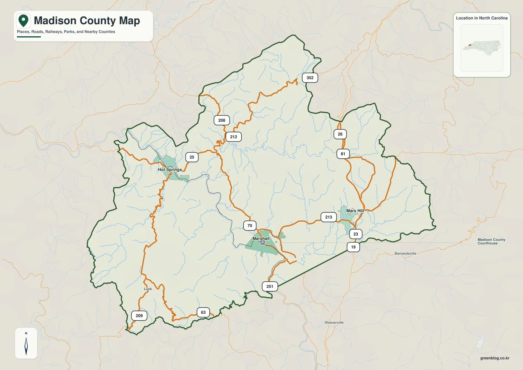
Marshall is the most useful starting point on the county reference map because it combines the administrative center with a clear road and river location. It sits in the southern part of the county along the French Broad River. From there, Hot Springs is west along the river corridor, while Mars Hill is northeast and separated from the main French Broad valley. The three places therefore form different orientation points rather than a single straight line of towns.
The road network reinforces that difference. Routes marked 25 and 70 follow the French Broad side of the county and help connect the Marshall-Hot Springs corridor. Around Mars Hill, Interstate 26 and routes 19, 23, and 213 stand out more clearly. Farther north and northwest, 208, 212, and 352 reach into narrow mountain valleys, while 209 and 63 appear in the southwestern part of the county. The roads twist and change direction often, which is exactly what you would expect in terrain where ridges limit the number of easy crossings.
Hot Springs occupies a distinctly western position close to the French Broad. Although Marshall is on the same river system, the two communities are separated by rugged terrain and a winding travel corridor. Mars Hill is different again. It lies away from the main river and is much more closely tied to the northeastern road network. If you are using the map to understand local access, it is better to think in terms of several mountain corridors than to treat every place as being equally centered on Marshall.
The county outline is irregular as well. A long northern projection and a broad, uneven western side contrast with the more angular southeastern edge. Small streams branch through much of the interior, so the boundary map is not simply an administrative shape floating over empty space. Roads, settlements, and watercourses fit together in a landscape where the usable routes are strongly influenced by the valleys between ridges.
Why Mars Hill, Marshall, and Hot Springs do not form one simple town corridor
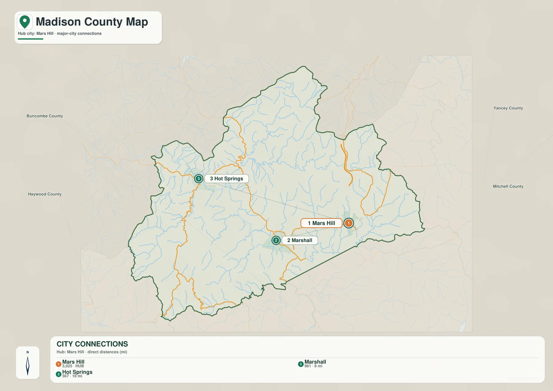
The city-connections map uses Mars Hill as the hub and draws direct lines to Marshall and Hot Springs. The distances printed on this map are straight-line distances, not road mileage. Marshall is shown about 8 miles from Mars Hill, while Hot Springs is about 16 miles away. Those numbers are useful for comparing relative position, but they should not be used as driving distances because mountain roads rarely follow the straight connecting lines drawn on the map.
Mars Hill occupies the northeastern side of the county, Marshall lies southwest of it in the French Broad valley, and Hot Springs is farther west. That gives the three communities a rough triangular arrangement. The geometry matters because it shows why a Marshall-only view can be misleading: Marshall is the county seat, but it is not geographically central to every settled area. Mars Hill provides a better reference for the northeast, and Hot Springs provides a separate reference for the western river valley.
The connecting lines are deliberately simple. They are not roads, rail lines, or recommended routes. A line from Mars Hill to Hot Springs crosses terrain that actual roads must work around or pass through by valleys. To understand travel, pair this city map with the county road map. The first image shows the real road pattern, while the city view strips away detail so the spacing between the three named places is easier to compare.
This difference also helps when the map is used for local research. Marshall is the logical reference for county government and administrative services. Mars Hill is useful when looking at the northeastern settlement area and the I-26 corridor. Hot Springs anchors the western side of the county along the French Broad. Using all three references prevents a mountain county with several distinct valleys from being reduced to one central dot.
French Broad River, tributary valleys, and the rugged interior
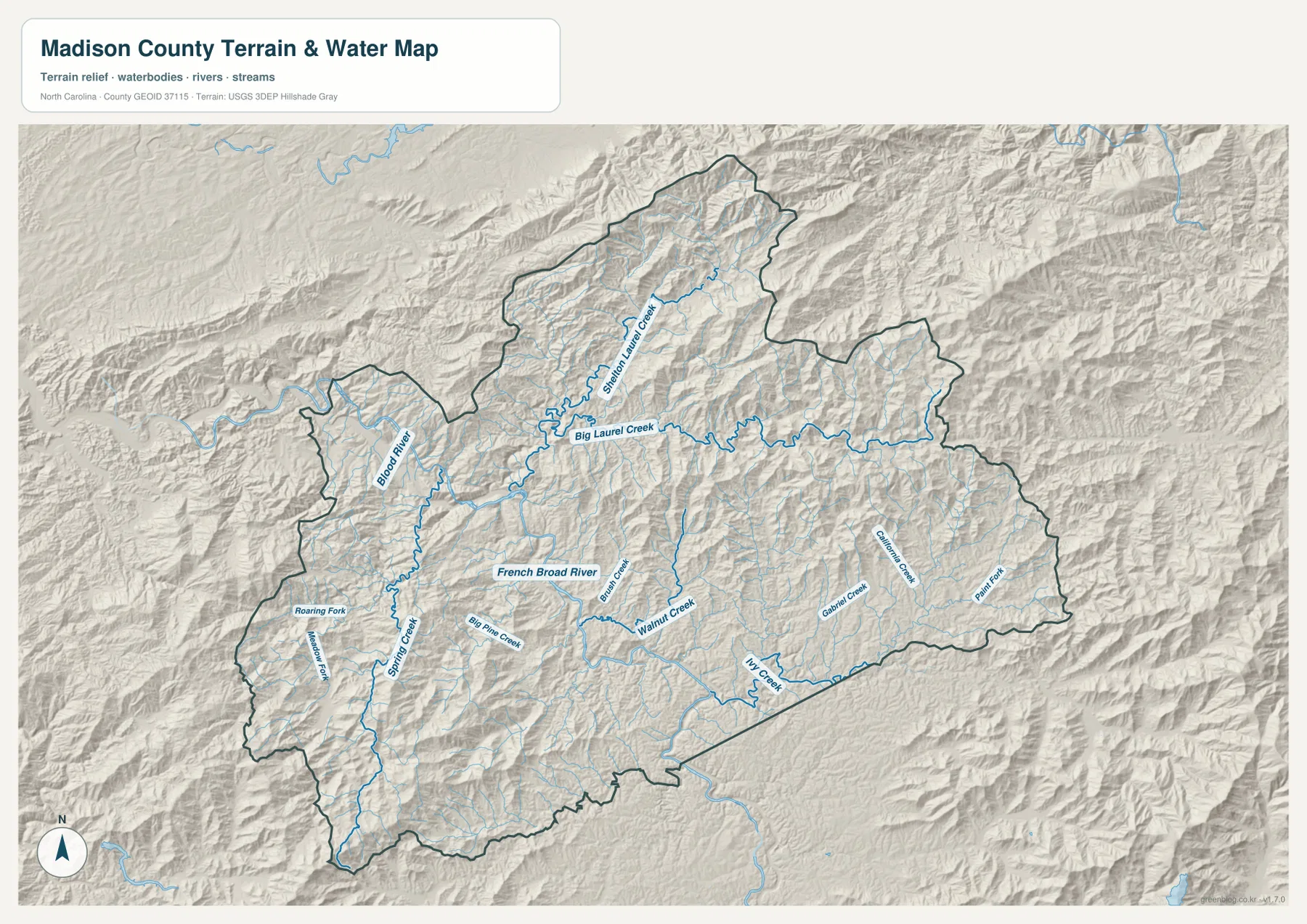
The terrain-and-water map shifts attention from roads to the physical landscape. The French Broad River enters from the southeastern side of the county, passes through the Marshall area, then bends west and northwest toward Hot Springs before continuing toward Tennessee. The shaded relief shows steep slopes close to the river in many places, so the main valley is easy to distinguish from the surrounding ridges. This is a useful reminder that the river is not simply a blue line on the map; it occupies one of the county’s most important low corridors.
Several named tributaries help explain the rest of the county. Big Laurel Creek and Shelton Laurel Creek drain long northern valleys toward the French Broad system. Walnut Creek and Big Pine Creek appear in the central part of the county, while Ivy Creek stretches across the south and southeast. Spring Creek and Roaring Fork mark additional western drainages. Together these streams form a branching pattern that follows the folds of the mountains rather than a regular street-like network.
The shaded terrain is especially pronounced in the north, around the Big Laurel and Shelton Laurel valleys, and in the western interior around Spring Creek. Closely spaced ridges create many small sub-valleys. That helps explain why two points that look close on a county-scale map may require a much longer road trip than the straight-line distance suggests. The river and creek valleys offer the most natural passages, while the surrounding ridges restrict cross-county movement.
This water map is intended as a geographic reference, not as a flood-hazard, parcel, legal-boundary, or navigation product. It is useful for seeing where the French Broad and major tributaries lie in relation to the terrain. Property-specific flood risk or legal stream boundaries should be checked with the appropriate official sources. For a county overview, however, the map gives a clear picture of how water and relief divide Madison County into a series of connected but distinct mountain valleys.
Putting the town locations back onto that physical pattern explains the county particularly well. Marshall and Hot Springs both belong to the French Broad corridor but occupy different sections of it. Mars Hill sits away from the main river and closer to northeastern roads and uplands. That is why the three towns are better treated as separate orientation points. Their locations make sense when the river valleys and ridges are visible underneath the road network.
Choosing the best Madison County map for your task
Use the county reference map when your main question is where a town, road, or boundary sits. It keeps the three named communities in their broader setting and shows the road numbers that connect different parts of the county. The city-connections map is better when you want a cleaner comparison of town spacing. Because its lines represent straight-line distance, it is a quick orientation tool rather than a route planner.
The terrain-and-water map is the strongest choice for understanding why the road network looks the way it does. The French Broad River and tributaries such as Big Laurel Creek, Walnut Creek, and Ivy Creek reveal the low corridors between ridges. The relief background shows the county’s rugged character without claiming survey-grade elevation accuracy. For most readers, checking the terrain map after the road map is the easiest way to connect named places with the mountain landscape around them.
If you need a larger copy for printing, classroom use, local reference work, or closer inspection of labels, the ZIP below contains the matching high-resolution A3 JPG files. The archive keeps all three supplied map types together, so you can save the full set without downloading each image separately from the page.
Frequently Asked Questions
Are the Mars Hill-to-Marshall and Mars Hill-to-Hot Springs distances driving distances?
No. The city-connections map labels them as direct, straight-line distances. Marshall is shown about 8 miles from Mars Hill and Hot Springs about 16 miles away. Actual road distance will be longer in many cases because roads follow valleys and mountain passes rather than the straight connecting lines.
Which tributaries are easiest to identify on the Madison County water map?
Big Laurel Creek and Shelton Laurel Creek are prominent in the north, Walnut Creek and Big Pine Creek cross central areas, and Ivy Creek is easy to follow across the south and southeast. These tributaries help show how the French Broad system is fed by many narrow mountain valleys.
Map File Information
Download the Madison County county map, city-connections map, and terrain-and-water map as three high-resolution A3 JPG files in one ZIP archive.
- Included Files: Use only the versions confirmed in the article and supplied images
- File Type: Use the confirmed download contents
- Intended Use: Printing, education, presentations, and map-based projects
Related Maps
Sources and references
Green Map creates custom-edited map images using open geographic data sources such as geoBoundaries, Natural Earth, OpenStreetMap, and government open data.
These maps are edited visual materials, not raw data files, and are provided for education, documents, presentations, and graphic reference.