The McCormick County Map shows a county that is easiest to understand from its middle and then downward toward its narrow southern end. McCormick sits near the center, Mount Carmel and Willington lie to the northwest, and Parksville, Modoc, and Clarks Hill continue south. Numbered roads branch in several directions around McCormick, while the terrain-and-water view replaces much of that road emphasis with Little River, Stevens Creek, other named creeks, and a broad reservoir-like shoreline along the west and southwest. The same map subjects are available below as A3 high-resolution JPG files in one downloadable ZIP.
Each supplied map answers a different practical question. The general county map is the best starting point for place names and numbered routes. The city-connections graphic simplifies the county to McCormick, Plum Branch, and Parksville so their relative positions are easy to compare. The terrain-and-water map is more useful when the goal is to locate Little River, Long Cane Creek, Rocky Creek, Hard Labor Creek, Cuffytown Creek, Stevens Creek, and the large water edge on the western side. Reading the three separately avoids turning one graphic into a street map, population map, and hydrography map at the same time.
Table of Contents
Roads fan out from McCormick toward Mount Carmel and Clarks Hill
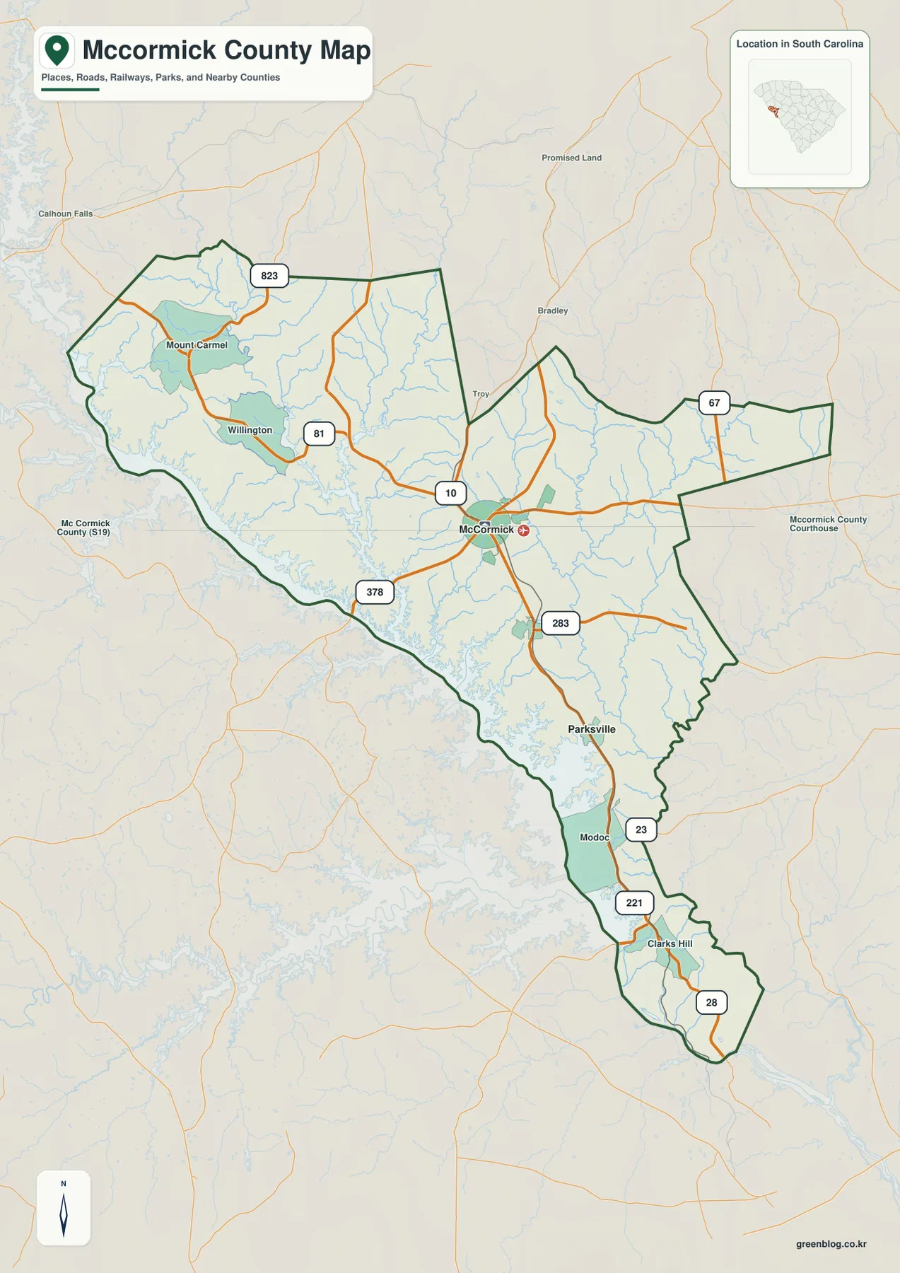
McCormick is the clearest hub on the general map. Route 10 crosses the central area, while 81 and 823 appear northwest toward Mount Carmel and Willington. Route 378 turns toward the western water edge, and the southern half adds 283, 23, 221, and 28 as the county narrows. Route 67 is shown on the eastern side. The result is not a single north-south corridor: several numbered roads meet or pass near the county seat, then separate toward distinct parts of the boundary.
The northwest has a compact group of labels around Mount Carmel and Willington, plus short stream lines and water inlets near the boundary. Moving south from McCormick, the sequence changes. Parksville appears first, followed by Modoc and then Clarks Hill closer to the narrow bottom of the county. That progression is useful because the outline becomes noticeably slimmer below the central area. Following the road shields through these places gives a better sense of the county’s length than looking at the outline by itself.
Some labels outside the dark green boundary provide orientation to nearby areas, but the map is not meant to document every road in neighboring counties. Its strongest use is county-scale comparison: finding which side of McCormick a place lies on, seeing where a major numbered road approaches the boundary, or comparing this long, irregular outline with adjacent South Carolina county maps. Local addresses, parcels, and turn-by-turn directions require a more detailed source.
Plum Branch is close to the hub; Parksville sits farther south
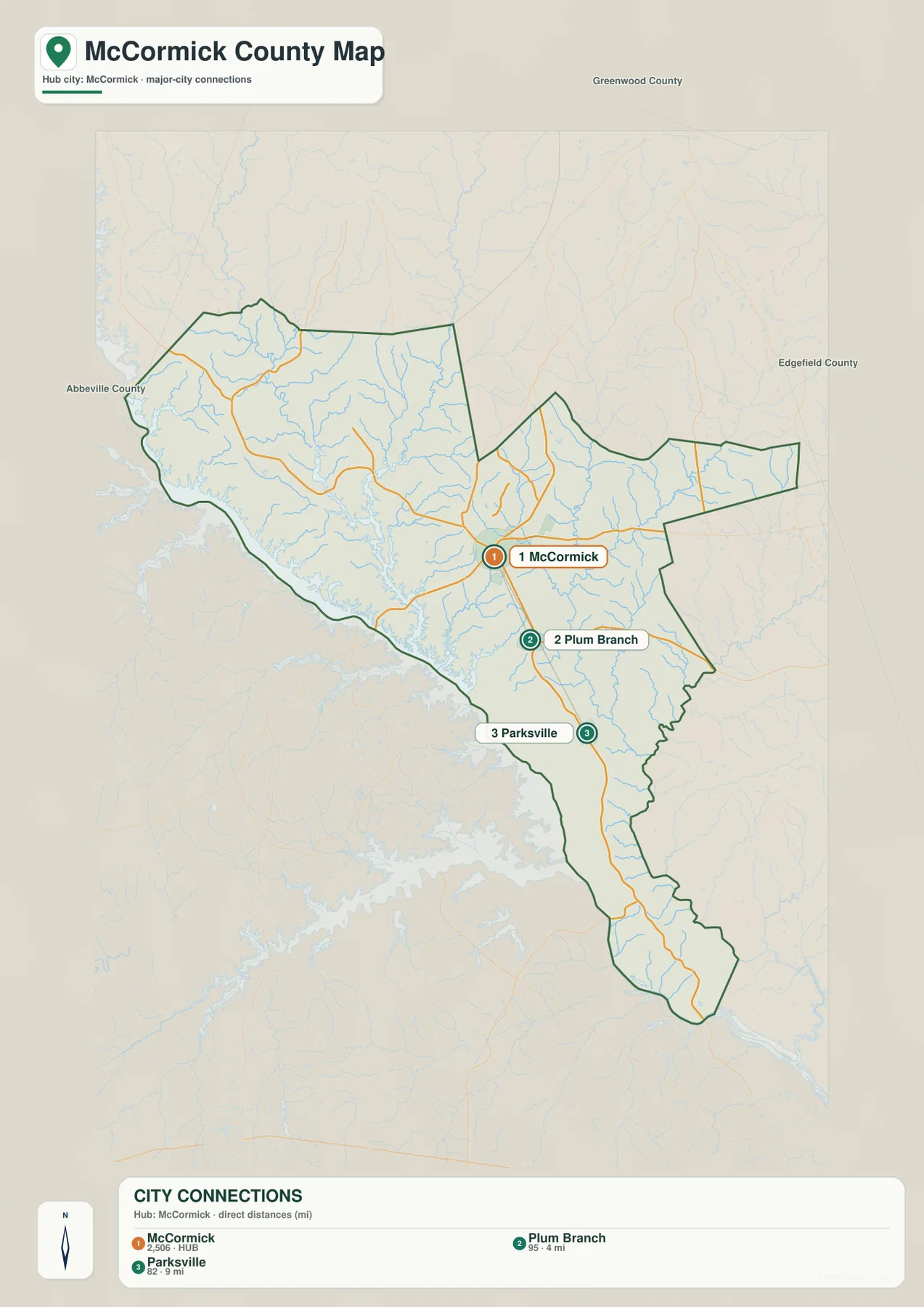
The city-connections graphic labels McCormick as number 1, Plum Branch as number 2, and Parksville as number 3. Its legend places Plum Branch about 4 miles from McCormick and Parksville about 9 miles away. Those values are straight-line distances between the mapped points, not driving distances along the road network. They are useful for comparing relative spacing, but an actual trip can be longer depending on the route taken.
Plum Branch appears just south of McCormick, while Parksville is farther down the county. The general map makes Parksville and the southern roads easy to see, but Plum Branch is much clearer in this simplified city view. Used together, the maps show that the settlements south of the hub are not concentrated in one compact cluster. They form a sequence that continues toward Modoc and Clarks Hill, matching the county’s long southern shape.
The legend also prints 2,506 for McCormick, 95 for Plum Branch, and 82 for Parksville. Because the preview does not state a reference year for those figures, this page treats them only as values printed on the supplied map, not as a claim about the latest population estimate. They help explain the visual hierarchy of the city graphic, but current population research should rely on a dated official statistical source.
Little River, eastern creeks, and the long western water edge
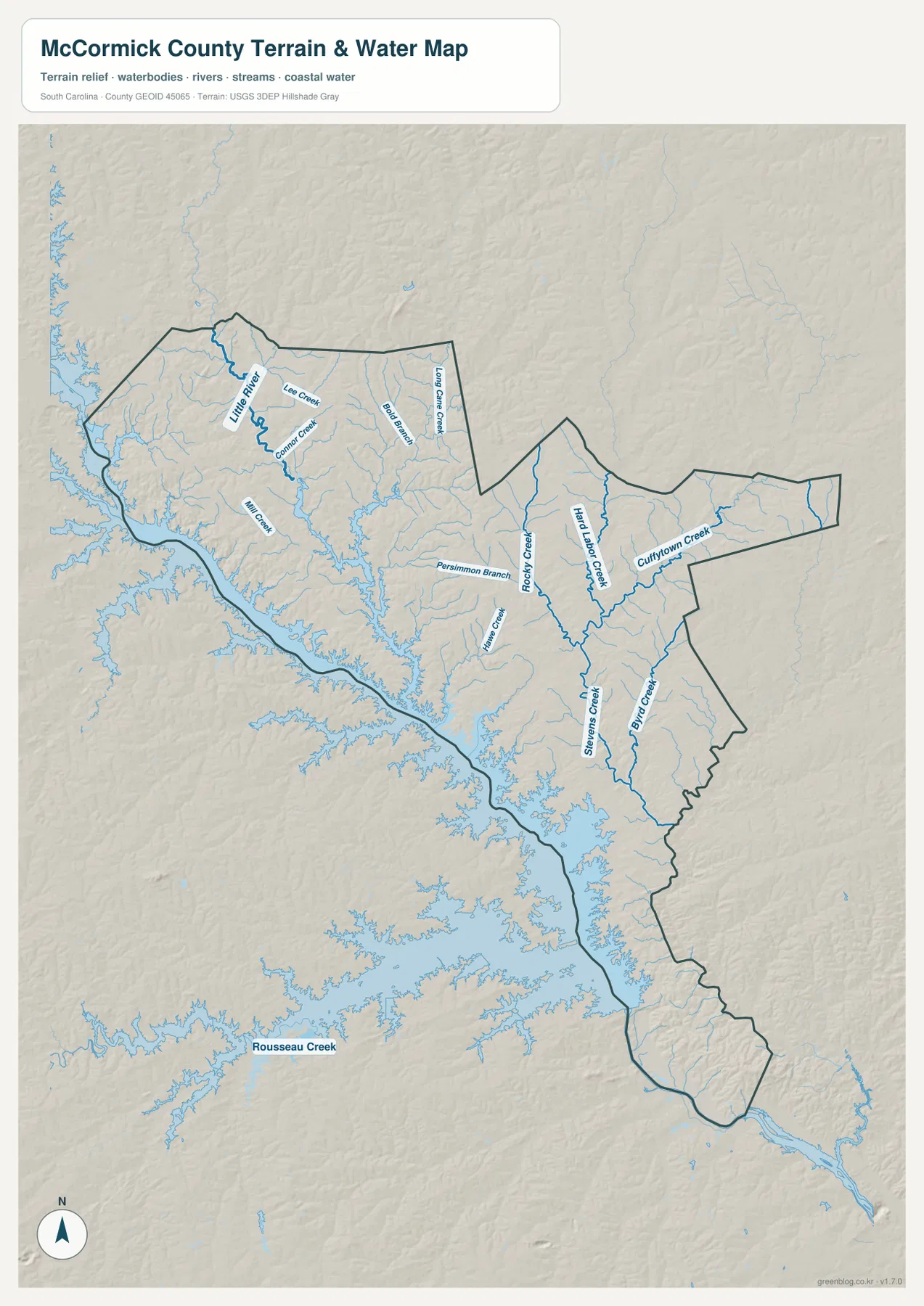
The water map changes the visual balance of the county. A broad, irregular water edge follows much of the west and southwest, while Little River is drawn prominently in the northwest. Lee Creek and Mill Creek are among the smaller labels in that side of the county. On the road map, the west can look like a simple outer boundary; here it becomes a complicated shoreline with narrow inlets and several tributaries feeding toward larger water.
The eastern half provides a different set of reference points. Long Cane Creek is labeled in the upper-right portion, and Rocky Creek, Hard Labor Creek, and Cuffytown Creek appear farther south. Stevens Creek runs through the lower central-to-eastern area, accompanied by smaller branches and tributaries. These streams are not presented as one continuous channel. They are separate names that help divide the county into recognizable water-drainage areas when town labels are sparse.
The shaded relief behind the blue water features gives a broad impression of terrain, but the graphic does not provide surveyed elevations, contour intervals, flood zones, water depth, or parcel boundaries. It is best used as a county-scale terrain-and-water reference. For a detailed hydrologic or elevation question, the map can serve as an orientation layer before checking USGS hydrography, 3D Elevation Program data, or another purpose-built official dataset.
Choosing the useful view for McCormick County
For a first look, start with the general map and locate McCormick where the numbered roads converge. Then trace the county south through Parksville, Modoc, and Clarks Hill, or northwest toward Mount Carmel and Willington. The city map is better when the question is simply how Plum Branch and Parksville relate to the hub. The water map becomes the better choice when Little River, eastern creeks, or the broad western shoreline matters more than the road network.
The three views also work differently in print. The general map carries the most place and road information, the city map is the cleanest for explaining settlement spacing, and the terrain-and-water map contains the most named drainage features. The ZIP below includes matching A3 high-resolution JPG files for all three subjects, making it possible to print them larger than the WebP previews or place them side by side in a report or presentation.
Frequently Asked Questions
Are the 4-mile and 9-mile city values driving distances?
No. The city-connections map uses straight-line distance from McCormick to the plotted locations. Plum Branch is labeled about 4 miles away and Parksville about 9 miles away. A driving route can be longer because it follows the available road network rather than a direct line.
Where are the most visible water features on the supplied map?
The broadest water edge lies along the west and southwest, while Little River is a prominent labeled feature in the northwest. Long Cane Creek, Rocky Creek, Hard Labor Creek, Cuffytown Creek, and Stevens Creek provide clear reference points across the eastern and southern parts of the county.
What is included in the downloadable ZIP?
The archive contains high-resolution A3 JPG versions of the county road-and-place map, the city-connections map, and the terrain-and-water map shown in the article. The on-page WebP files are intended for quick viewing, while the JPG versions are better suited to larger print or document use.
Map File Information
Download the McCormick County road-and-place map, city-connections map, and terrain-and-water map as three A3 high-resolution JPG files in one ZIP.
- Included Files: Road-and-place map, city-connections map, and terrain-and-water map
- File Type: Three high-resolution A3 JPG files bundled in one ZIP archive
- Intended Use: Printing, education, presentations, and map-based projects
Related Maps
Sources and reference data
- South Carolina Association of Counties – County Information: county-level reference information
- U.S. Census Bureau TIGER/Line Shapefiles: county boundaries, roads, and geographic reference data
- USGS National Hydrography: stream and water-feature reference
- South Carolina Geological Survey: statewide terrain and geology reference
Green Map creates custom-edited map images using open geographic data sources such as geoBoundaries, Natural Earth, OpenStreetMap, and government open data. These maps are edited visual materials, not raw data files, and are provided for education, documents, presentations, and graphic reference.