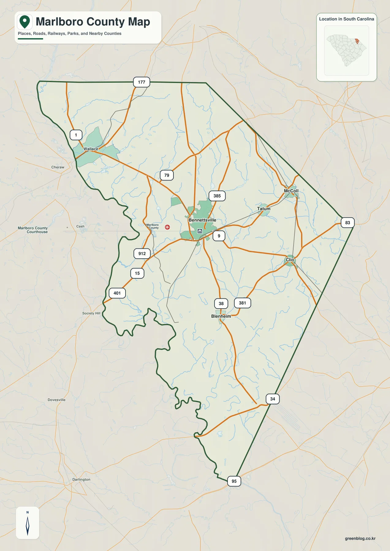
You can download the Marlboro County Map on this page as A3 high-resolution JPG files bundled in one ZIP. The maps cover Bennettsville, McColl, Clio, Blenheim, and Tatum, along with numbered roads, named creeks, ponds, and lakes across a county that is broad in the north and narrows into a long southern section. The on-page WebP versions make it easy to compare those features before downloading the full-size files.
Bennettsville is the easiest place to start because it sits near the middle of the populated northern half and several numbered routes meet around it. McColl and Tatum lie to the northeast, Clio is farther east, and Blenheim is south of Bennettsville. That arrangement gives the page a useful structure: first establish the county shape and road network, then compare the five indexed places, and finally switch to the water map to see what fills the spaces between them.
Table of Contents
Roads around Bennettsville and the long southern county shape
The general county map places Bennettsville at a junction of several routes rather than at the geometric center of the outline. Route 9 crosses the city area, while 385 approaches from the north and 15, 401, and 912 appear on the western and southwestern side. Farther north and northwest, 1 and 177 provide other reference lines. To the east and south, the map labels 83, 38, 381, 34, and 95, showing that the road pattern changes as the county narrows toward its lower end.
Place labels help break that road network into recognizable sections. Wallace appears near the western edge, McColl near the northeastern side, Tatum between McColl and Bennettsville, Clio to the east, and Blenheim to the south. The map also shows many small streams, so the road lines do not cross an empty background; they run through a landscape cut by numerous drainage channels. The purpose here is orientation rather than turn-by-turn navigation, so local streets and every settlement are not included.
Five indexed places from Bennettsville to Tatum
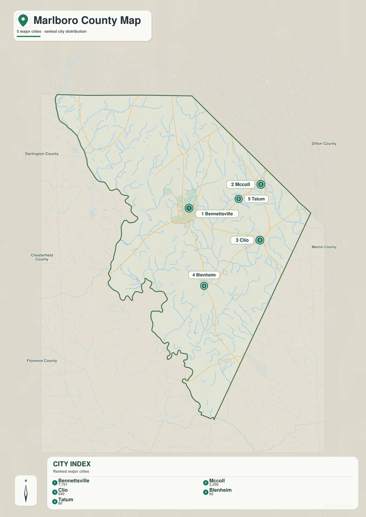
The city map removes most of the road emphasis and makes settlement position the main subject. Bennettsville is ranked first on the supplied index, McColl second, Clio third, Blenheim fourth, and Tatum fifth. Bennettsville occupies the central-northern part of the county, while McColl and Tatum form a small northeastern grouping. Clio sits farther southeast of them, and Blenheim is distinctly south of Bennettsville. The spread makes it clear that the named communities are not arranged along a single corridor.
The printed city index also gives values of 7,751 for Bennettsville, 2,200 for McColl, 840 for Clio, 82 for Blenheim, and 80 for Tatum. Because the preview itself does not state a reference year, those numbers are best treated as values printed on this map rather than as a claim about the latest population estimate. They are still useful for understanding why Bennettsville and McColl are visually emphasized more strongly than the smaller places.
County names around the outside add another layer of orientation. Darlington County and Chesterfield County appear on the west, Dillon County on the northeast, Marion County on the east, and Florence County to the southwest. Those labels are useful when comparing neighboring county pages, but the city map remains focused on the five places inside Marlboro County rather than on detailed boundary surveying.
Creeks, mill ponds, and small lakes across the county
The terrain-and-water map is much more detailed than the city map. White Creek crosses the upper-left portion near Everette Mill Pond, while Andersons Mill Pond and Davids Mill Pond appear farther south along the western side. Near the center, Naked Creek runs toward an area that includes Burnt Factory Pond and Lake Wallace. These names make the northern half of Marlboro County look less like a simple road map and more like a patchwork of short drainage lines and small impoundments.
The northeastern half adds Crooked Creek, Mc Nairs Mill Pond, and Beaverdam Creek, with Red Bluff Lake close to the eastern edge. In the southern half, Drakes Pond is one of the clearer named water bodies, and the map labels Three Creek and Rogers Creek Canal farther down. No single large lake dominates the county on this preview. Instead, the visual pattern comes from many small creeks, ponds, and narrow channels distributed through a gently shaded terrain surface.
The gray hillshade behind the waterways provides a general sense of relief, but it should not be read as engineering-grade elevation measurement. Likewise, the blue lines and ponds identify water features for reference; they do not show flood probability, navigable channels, parcel boundaries, or legal access. For those questions, a specialized official dataset is required.
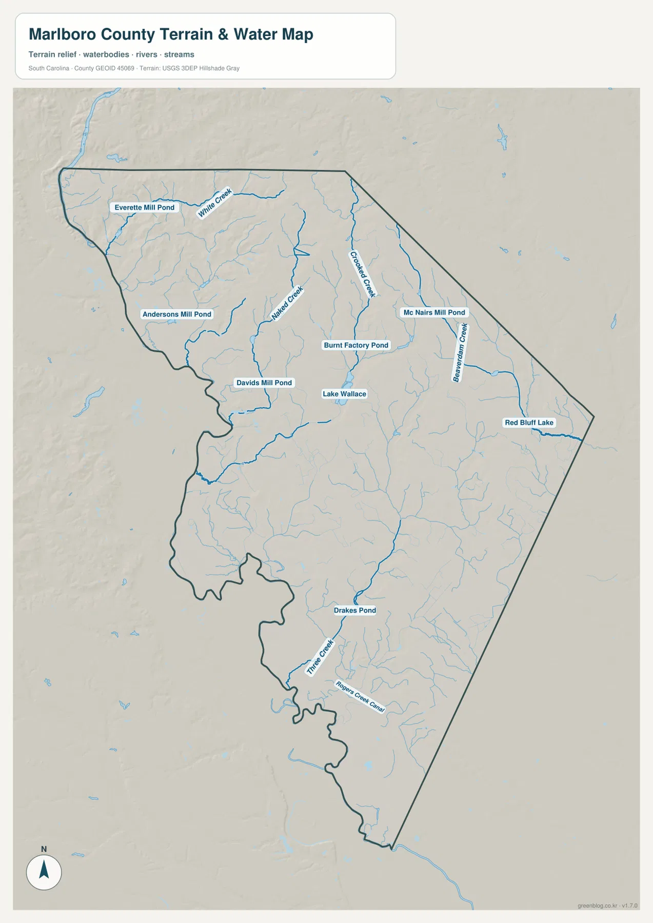
There is also a noticeable north-to-south change in how the named water features are distributed. The northern half has several closely spaced labels for ponds and creeks, which makes Lake Wallace, Burnt Factory Pond, Crooked Creek, and Beaverdam Creek useful orientation points around the more populated area. Farther south, the county outline becomes narrower and named towns become less frequent, so Drakes Pond and Rogers Creek Canal provide clearer reference points. That contrast is useful when moving between the city map and the water map: the same county shape looks much more detailed once the drainage lines replace the settlement labels.
Moving from roads to towns to waterways
For a quick reading, begin with the general county map and find Bennettsville where several numbered routes converge. The city map then clarifies how McColl, Tatum, Clio, and Blenheim are distributed around that center. Finally, the water map explains why large parts of the county contain many thin blue lines even where few town names appear. Using the views in that order gives a more complete picture of Marlboro County without treating any single map as a street map, hydrologic model, or survey product.
Frequently Asked Questions
Are the numbers in the city index guaranteed to be the latest population figures?
No reference year is printed on the supplied preview, so this article does not present those values as the latest census estimate. They are described as the figures shown on the map and are most useful for comparing the relative prominence of Bennettsville, McColl, Clio, Blenheim, and Tatum within this specific city-index graphic.
Which named water features are easiest to locate?
White Creek, Naked Creek, Crooked Creek, and Beaverdam Creek are among the clearest stream labels in the northern half. The map also identifies Everette Mill Pond, Burnt Factory Pond, Mc Nairs Mill Pond, Lake Wallace, Red Bluff Lake, and Drakes Pond, giving readers several reference points from west to east and north to south.
Can the terrain-and-water map be used as a flood or property-boundary map?
No. It is a reference map for terrain shading and named water features. It does not provide flood zones, parcel boundaries, surveyed elevations, or legal property information, so those decisions should be based on the appropriate official flood, cadastral, or survey records.
Map File Information
The county map, city map, and terrain-and-water map are available as matching A3 high-resolution JPG files. All three are packaged together in one ZIP for printing, classroom use, presentations, or side-by-side county comparison.
- Included Files: county map, city map, terrain and water map
Related Maps
Sources and reference data
- South Carolina Association of Counties – County Information: general county reference
- U.S. Census Bureau TIGER/Line Shapefiles: county boundaries, roads, and place reference data
- USGS National Hydrography: streams and water-feature reference
- South Carolina Geological Survey: statewide terrain and geology reference
Green Map creates custom-edited map images using open geographic data sources such as geoBoundaries, Natural Earth, OpenStreetMap, and government open data.
These maps are edited visual materials, not raw data files, and are provided for education, documents, presentations, and graphic reference.