The most useful way to read this Marion County South Carolina Map is to notice how strongly the county changes from north to south. Marion and Mullins sit in the broader northern part of the county, where several highways and a rail line converge. Nichols and Sellers provide additional reference points near the outer edge of that northern cluster. South of Marion, named places become less frequent while the county continues for a long distance through a narrower shape. The three map views on this page separate those jobs: one emphasizes roads and places, one compares the major city points around Marion, and one brings the Little Pee Dee River, creeks, swamps, ponds, and lakes to the foreground. A high-resolution A3 JPG ZIP can be downloaded from the map file box below.
That long shape matters because a quick glance at the northern towns can give the impression that Marion County is mostly a compact Marion–Mullins area. It is not. The boundary stretches well to the south, and the character of the map changes as it does. Roads remain important, but water features become especially helpful for keeping your bearings in the central and southern portions. Reading the road map and water map together is therefore more informative than treating the county as a single outline with two labels.
Table of Contents
Roads gather around Marion and Mullins before the county narrows southward
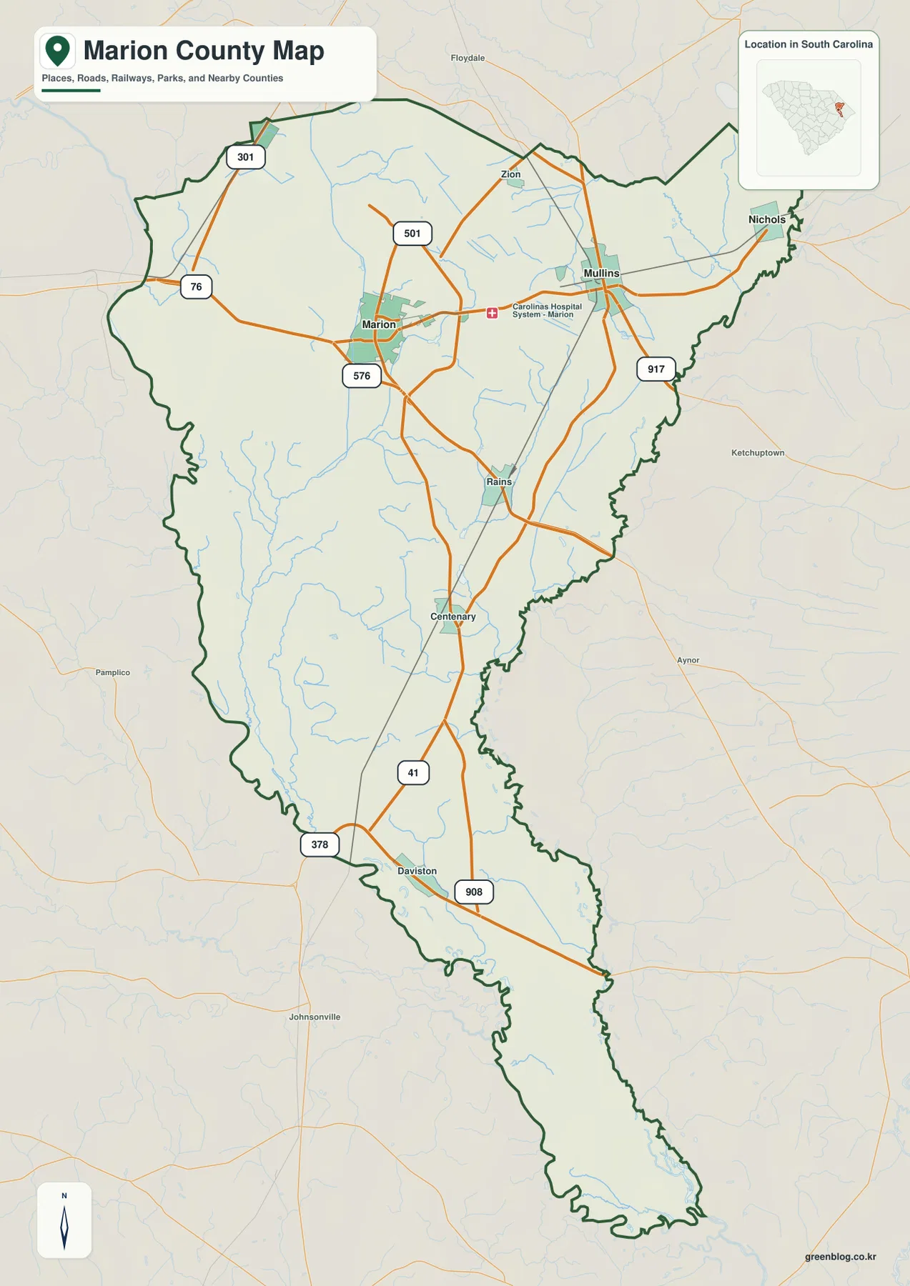
Marion and Mullins are the clearest urban anchors on the general county map. Route 501 approaches Marion from the north and continues through the area, while Route 576 is marked close to the city. Route 76 enters from the west. Around Mullins, the east–west road pattern is joined by Route 917, and a rail line runs through the Marion–Mullins corridor. These features make the northern part of the county visually busy compared with the long southern extension.
The map also gives a sequence of smaller places that helps with orientation. Sellers appears near the northwestern side, while Rains and Centenary lie south of Marion and Daviston is farther down the county. Route 41 follows much of the long north–south direction, and Routes 378 and 908 appear in the southern half. The road network is not uniform: many connections concentrate around the northern towns, then spread out as the boundary becomes narrower toward the south.
This view is best for county-scale questions rather than address-level navigation. It shows enough roads to explain how Marion, Mullins, and the smaller named places relate to one another, but it is not a replacement for a street map. The county boundary is also easier to understand when the outside context is visible. Florence County lies to the west, while Horry County is shown to the east; the broader group of neighboring counties also includes Dillon, Georgetown, and Williamsburg. Those surrounding names explain why the county’s northern and southern edges do not form a simple rectangle.
One more useful detail is the contrast between the north and south. The northern map includes more named settlements, intersecting roads, and the hospital symbol near the Marion–Mullins corridor. The southern half has fewer town labels but remains geographically substantial. If you are comparing Marion County with other South Carolina counties, that elongated form is one of the first things worth noticing because it affects how roads and waterways appear within the same page frame.
From the Marion hub, Mullins, Nichols, and Sellers spread in different directions
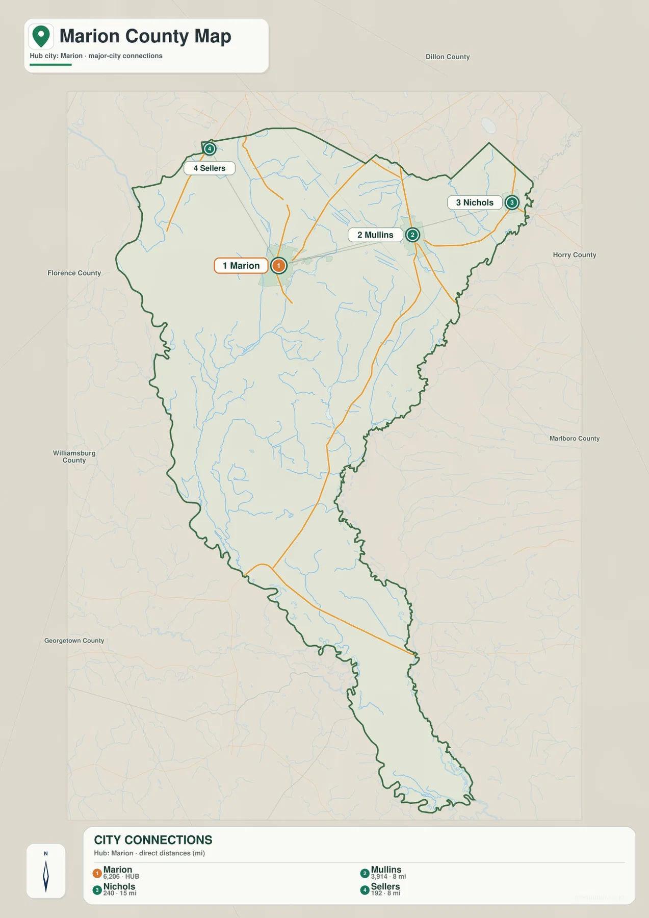
The city-connections map simplifies the county so that four settlement points stand out. Marion is marked as the hub. Mullins is approximately 8 miles away, Nichols about 15 miles, and Sellers about 8 miles. These values are straight-line distances between the mapped points, not driving distances along highways. They are useful for comparing direction and separation, but a road trip will usually cover a different distance because the road network bends and does not follow a direct line.
Mullins and Sellers are both close to the 8-mile range from Marion, yet they occupy very different sides of the hub. Mullins is to the east-northeast, within the same broad northern cluster. Sellers lies toward the northwest boundary. Nichols is farther east and near the county’s northeastern edge. That simple geometry explains more about the northern settlement pattern than a list of town names: Marion acts as a central reference, but the other points fan outward rather than lining up along one road.
The legend also shows a large difference in the population figures attached to the mapped places. Marion is listed at 6,206 and Mullins at 3,914, while Nichols is shown at 240 and Sellers at 192. Those values are reference statistics, not mapped city boundaries. A larger number does not mean a larger colored polygon on this map, because the graphic is designed to compare city points and distances rather than municipal land area. The figures instead help explain why Marion and Mullins function as the two most prominent named centers in the northern part of the county.
This is also a useful map for understanding what is missing from the southern portion. The selected city connections are all concentrated in the north, while the county continues far below them. That does not mean the southern area is empty. It means the map’s chosen major-city comparison is focused on the northern settlement cluster. To understand the long southern half, the water map adds much more detail than the city map does.
Little Pee Dee River, creeks, swamps, and mill ponds fill the water map
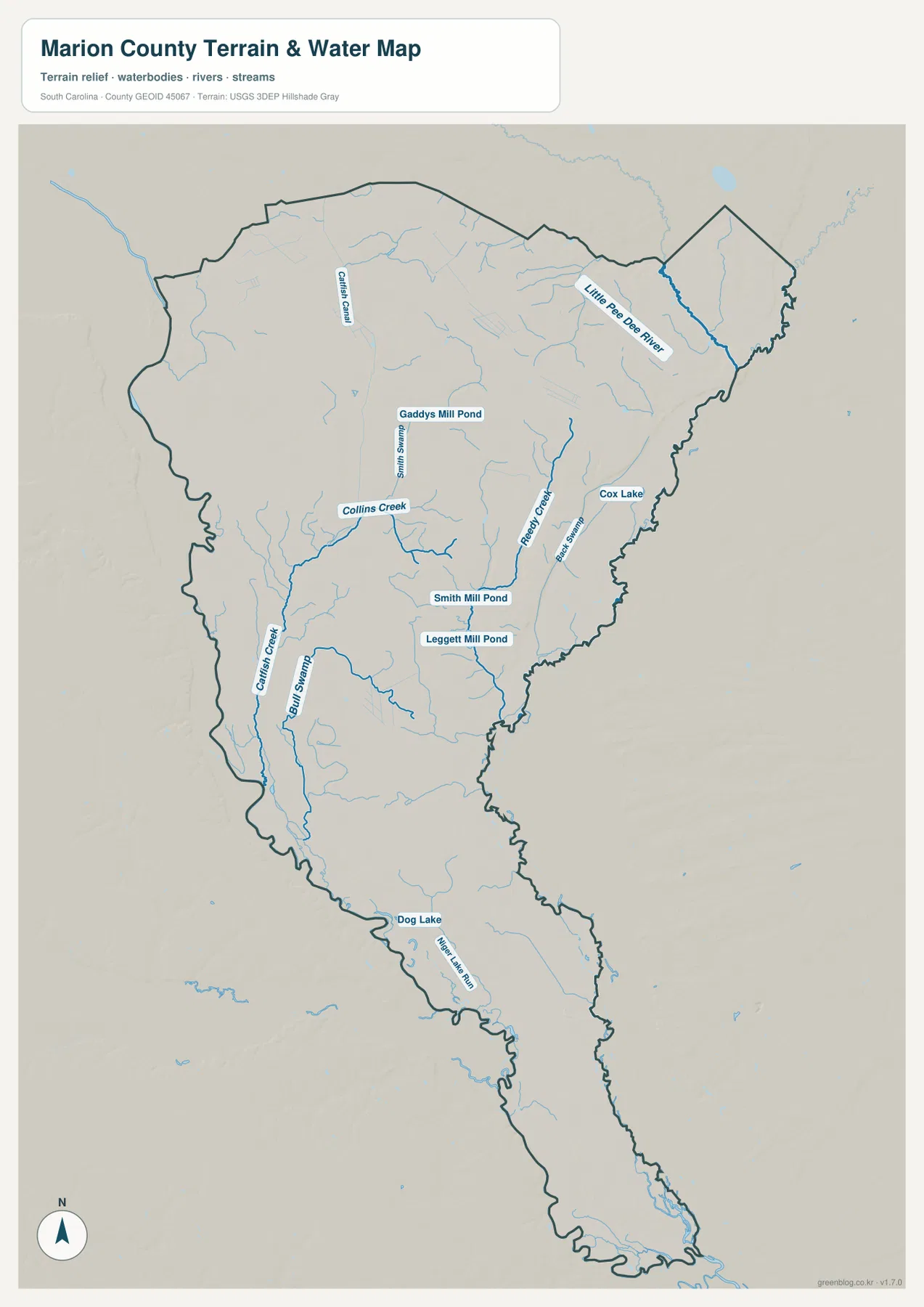
The water map changes the emphasis completely. The Little Pee Dee River is the most prominent named river in the northeastern part of the county, while Catfish Creek appears farther west in the northern interior. Collins Creek and Ready Creek stand out through the middle, and Raft Swamp marks a long watery corridor on the western side. Smaller tributaries branch around them, making the county look much more densely connected by water than it does on the city map.
Several named ponds and lakes provide additional landmarks. Gaddys Mill Pond is shown in the north-central area. Smith Mill Pond and Leggett Mill Pond appear farther south, while Cox Lake sits closer to the eastern side. Dog Lake is marked in the southern half. These are especially useful when you are trying to locate a creek or swamp that does not pass near one of the main towns. Instead of using only Marion or Mullins as reference points, you can use the nearest named pond or stream to narrow the area.
The map also makes the county’s long shape easier to interpret. Waterways continue through the central and southern sections even where named towns are sparse. On the western side, Collins Creek and Raft Swamp help trace the landscape southward. In the east-central area, Ready Creek and nearby swamp channels create another line of reference. This does not mean every blue feature is suitable for navigation or recreation; the map is a geographic reference showing mapped water bodies and drainage features, not a boating chart, flood map, or parcel survey.
A generalized terrain background sits beneath the waterways, but the page does not provide survey-grade elevation values. The relief is best treated as visual context. The stronger information is the relationship among the county outline, the named river and creeks, and the pattern of ponds and swamps. If you need to explain why the southern half still contains many recognizable geographic features even though the city map has fewer labels there, this water view provides the clearest answer.
Choosing among the files is straightforward once the question is clear. Use the general county map when roads, rail lines, Marion, Mullins, and the full boundary matter. Use the city-connections map when the relative positions of Marion, Mullins, Nichols, and Sellers are the focus. Use the water map when the Little Pee Dee River, Collins Creek, Ready Creek, Raft Swamp, ponds, and smaller streams are more important than road detail. The downloadable ZIP contains high-resolution A3 JPG versions of all three supplied map views for printing or reuse outside the web page.
Frequently Asked Questions
Are the 8-mile and 15-mile city distances driving distances?
No. The city-connections map uses straight-line distances from Marion to Mullins, Nichols, and Sellers. Actual road mileage can be longer because highways follow their own routes. The numbers are best used to compare relative position and separation.
Which water feature is easiest to identify first on the Marion County water map?
The Little Pee Dee River is the clearest major river label and appears near the northeastern side of the county. From there, Collins Creek, Ready Creek, Raft Swamp, and the named mill ponds provide useful reference points farther south and west.
What is included in the downloadable ZIP?
The ZIP contains high-resolution JPG versions of the same three map types shown on this page: the county road-and-place map, the city-connections map, and the terrain-and-water map. The web images are lightweight previews; the JPG files are prepared at A3 size.
Map File Information
Download the Marion County map set as one ZIP containing three high-resolution A3 JPG files for roads and places, city connections, and waterways.
- File Type: ZIP with three high-resolution A3 JPG files
Related Maps
Sources and References
- South Carolina Association of Counties – County Information: county administration and reference information
- U.S. Census Bureau TIGER/Line Shapefiles: county boundary, roads, and geographic reference data
- USGS National Hydrography: rivers, streams, and other hydrographic reference data
- South Carolina Geological Survey: statewide geology and terrain reference material
Green Map creates custom-edited map images using open geographic data sources such as geoBoundaries, Natural Earth, OpenStreetMap, and government open data.
These maps are edited visual materials, not raw data files, and are provided for education, documents, presentations, and graphic reference.