You can download the three high-resolution JPG files in this Calhoun County South Carolina Map set together as one ZIP directly from this page. The maps cover features that are easy to recognize on the supplied images: St. Matthews near the middle of the county, Cameron farther south, major numbered roads crossing the boundary, and a dense network of rivers, creeks, swamps, and ponds. The county reference map is best for roads and place names, the city view isolates St. Matthews and Cameron, and the terrain-and-water map makes the Congaree River and smaller waterways much easier to see.
The county outline has several very different edges. Its west side includes a narrow northern extension and a broad angular section, while the north and east sides bend repeatedly. St. Matthews sits close to the center of the mapped road network, Cameron is positioned toward the southern projection, and Sandy Run appears in the northwest. Routes marked 26, 21, 601, 33, 6, 267, 419, and 176 give the map a practical frame of reference without turning it into a street-by-street navigation product.
Water becomes a stronger reference on the third map. The Congaree River runs near the northern boundary, Sandy Run Creek is labeled in the northwest, and named streams such as Bates Mill Creek and Buck Head Creek cross other parts of the county. Farther south, Caw Caw Swamp Creek, Halfway Swamp Creek, Four Hole Swamp, Flax Bite Creek, and Huttos Pond add detail that is largely absent from the city view. These features help explain why parts of the county boundary look much more irregular than the long straight segments on the southwest side.
Table of Contents
St. Matthews at the center of the road map
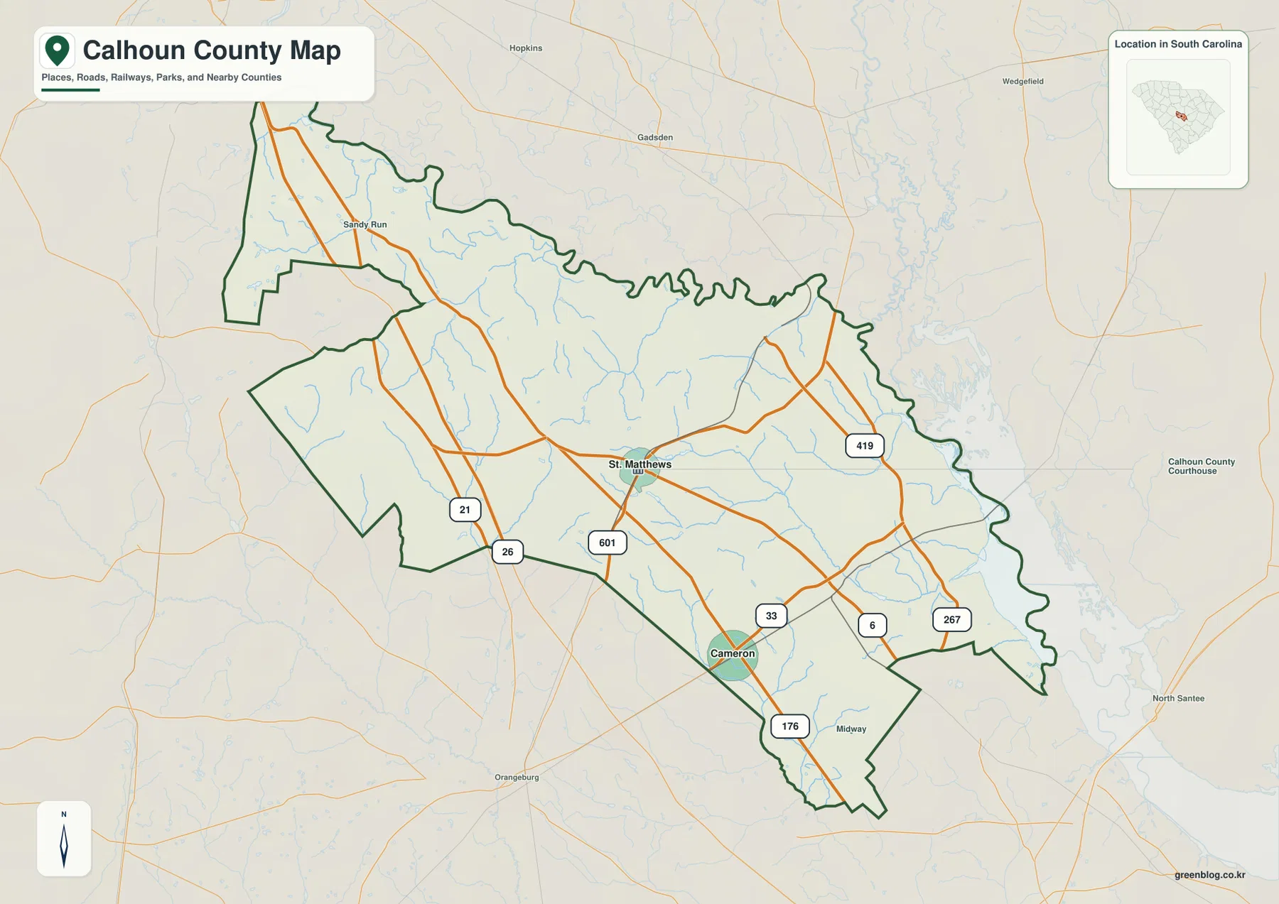
St. Matthews is the easiest place to use as the starting point on the county map. It appears near the middle of Calhoun County where several road lines meet or pass nearby, including Route 601. Because St. Matthews is also identified in the supplied county material as the county seat, its position provides both a geographic and an administrative reference. Once that point is located, Cameron can be found to the south and the narrower western and southeastern sections of the county become easier to place.
The west side of the map is defined in part by Routes 26 and 21. Those roads run close to the western boundary before the county outline steps inward and then extends north toward Sandy Run. The shape is unusual enough that the road lines are useful for confirming which side of the boundary a viewer is looking at. Orangeburg appears outside the county to the southwest, while Hopkins and Gadsden are visible north of the mapped boundary, providing additional orientation without being presented as Calhoun County communities.
South of St. Matthews, Cameron sits near the routes labeled 33 and 176. The county narrows into a southern projection below this area, so Cameron is a useful marker for distinguishing the central body of Calhoun County from its lower tip. On the east side, Routes 419, 6, and 267 provide separate reference lines. They are especially helpful because the eastern boundary is curved and irregular rather than a single straight edge.
The map also includes Sandy Run in the northwest and Midway near the southeast. These smaller labels should be treated as orientation points, not as a complete inventory of every settlement in the county. Similarly, the numbered routes are a selected network rather than a full road database. For a presentation, county profile, or printed comparison, that selectivity is useful because it keeps the county shape and major places readable at a glance.
Two city markers separated from the center to the south
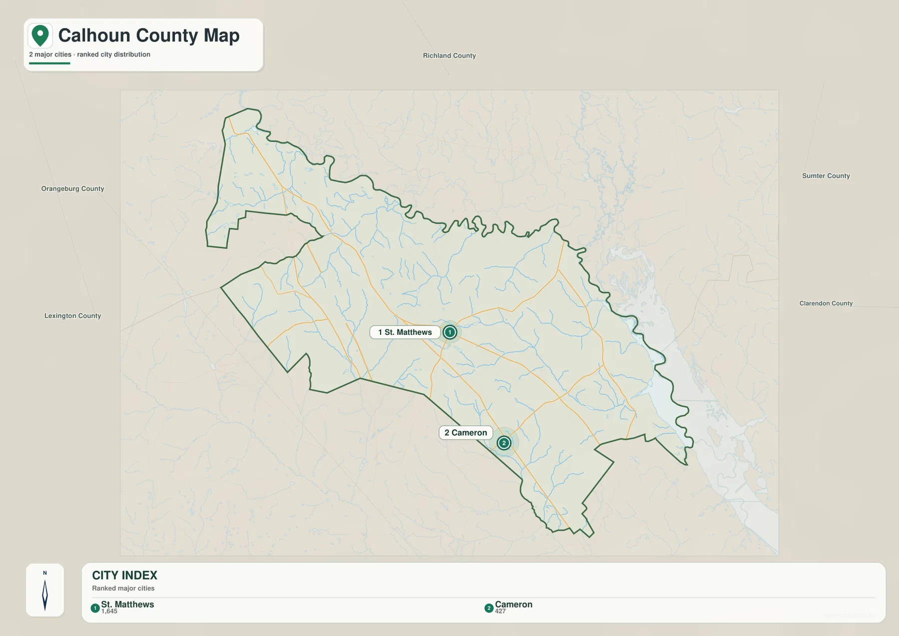
The city distribution map strips away much of the road detail and focuses on two ranked places. St. Matthews is marked as number 1 and Cameron as number 2. The City Index at the bottom also shows values of 1,645 for St. Matthews and 427 for Cameron. Those figures are best read as the values used by this map’s city index rather than as a claim that the page has independently verified the latest municipal population estimate.
The spatial difference between the two places is more important than the ranking alone. St. Matthews is close to the county’s central area, while Cameron is clearly south of it. The separation makes the pair useful for explaining the county from top to bottom: a reader can locate St. Matthews first, move toward Cameron, and then see how the boundary narrows farther south. The city view therefore works well when the goal is to teach relative location without the visual weight of many road numbers.
Five surrounding county names appear outside the boundary: Richland County to the north, Sumter County and Clarendon County to the east, Lexington County to the west, and Orangeburg County to the west and southwest. These labels make the city map useful for county-to-county orientation as well as settlement distribution. They also correspond with the very different boundary shapes around Calhoun County, from longer straight sections in the southwest to the winding northern and eastern edges.
The supplied background material identifies Calhoun County as founded in 1908 and lists St. Matthews as the county seat. It also gives an SCAC population reference of 14,119 and a land area of 380 square miles. Those facts are not drawn as map symbols, so they should remain supporting context rather than replacing what is visible. The maps themselves are strongest when used to explain where St. Matthews and Cameron sit, how the roads cross the county, and where the boundary meets neighboring counties.
Congaree River, creeks, swamps, and ponds on the terrain view
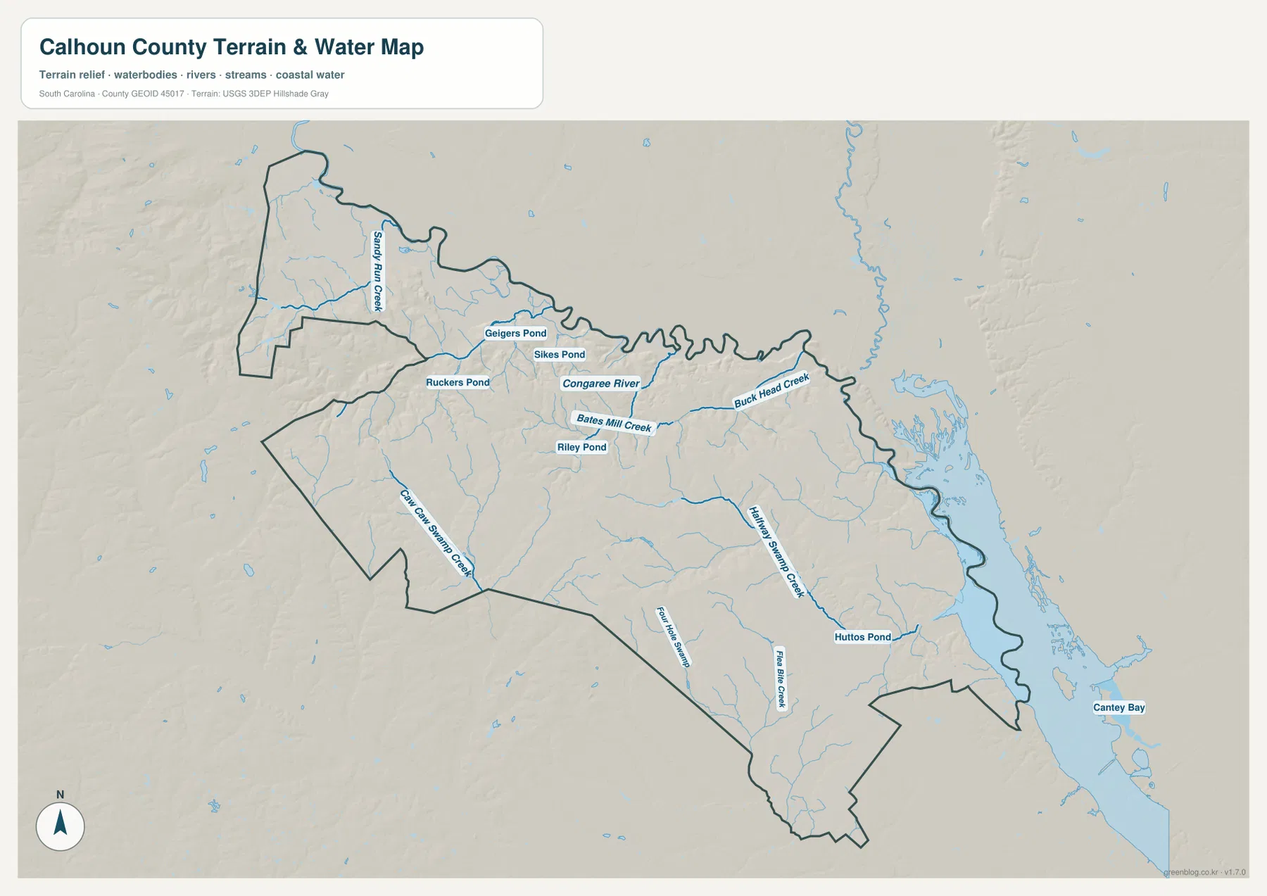
The Congaree River is the clearest named river on the terrain-and-water map. It lies close to the northern part of Calhoun County and is drawn with a heavier blue line than many of the smaller tributaries. That makes it a useful feature for comparing the water map with the county outline: where the basic map shows a highly winding northern edge, the water view shows a major river and numerous smaller channels in the same general area.
The northwest contains another recognizable group of water features. Sandy Run Creek is labeled near the upper-left part of the county, while Geigers Pond, Sikes Pond, and Ruckers Pond appear nearby. Moving toward the center, Bates Mill Creek and Riley Pond are labeled, and Buck Head Creek stretches eastward. This cluster of names gives the northern half of the county far more detail than the city map, which intentionally emphasizes only the two main place markers.
The southern half has its own set of water references. Caw Caw Swamp Creek runs diagonally through the southwest, while Halfway Swamp Creek is shown farther east. Four Hole Swamp and Flax Bite Creek appear toward the lower central part of the county, and Huttos Pond is labeled to the southeast. The repeated use of “swamp” in mapped names should not be interpreted as a legal wetland boundary or a statement about land-use restrictions; the map is showing named hydrographic features and terrain context.
A broad water area follows the eastern side of the map, and Cantey Bay is labeled beyond the southeast edge. The county boundary bends along this side instead of following the long straight lines seen in the southwest. Terrain shading is included behind the waterways, but it is generalized background relief rather than survey-grade elevation data. This view is appropriate for understanding where water features sit relative to the county; it is not a flood-risk, parcel, engineering, or navigation map.
What changes when roads and waterways are compared
Reading the county map and water map side by side reveals a useful contrast. In the west, Routes 26 and 21 and the road toward Sandy Run are fast visual guides. Around the middle, St. Matthews and Route 601 provide the clearest orientation. Farther east, however, the winding boundary and water features become just as important as the road numbers. Buck Head Creek, the larger eastern water body, and the routes marked 419, 6, and 267 all help define that side of the county.
Cameron provides a similar bridge between the road and water views in the south. On the basic map, Routes 33 and 176 make its location easy to identify. On the terrain-and-water map, the southern half is crossed by several named swamp creeks and smaller branches. A viewer who switches between the two maps can therefore connect the place-and-road reference around Cameron with a more detailed picture of the nearby drainage network without assuming that either map contains every local road or every stream.
The north side is different again. The boundary bends repeatedly, and the Congaree River gives that part of the map a strong natural reference. In contrast, the southwest edge contains longer straight boundary segments and fewer dominant water labels. This is one reason a single outline map does not tell the full story of Calhoun County: the basic shape, settlement pattern, and water network each make a different part of the county easier to understand.
For a class presentation or county comparison, a clear sequence is to begin with St. Matthews, move south to Cameron, then return north to the Congaree River and west to Sandy Run Creek. That path avoids an artificial list of every label while still covering the major visual anchors supplied in the package. Adding Buck Head Creek and the southern swamp features afterward gives the reader enough detail to understand why the county’s east and north sides look different from its straighter western and southern sections.
Choosing the Calhoun County file that fits the task
Use the county reference map when boundaries, places, and major numbered roads all need to appear together. It is the most direct choice for locating St. Matthews and Cameron while also showing Routes 26, 21, 601, 33, 6, 267, 419, and 176. Because nearby names such as Sandy Run, Midway, Hopkins, Gadsden, Orangeburg, and North Santee are visible around the frame, the map also works well when explaining where Calhoun County sits within the surrounding part of South Carolina.
The city distribution map is cleaner when the question is simply where the two principal indexed places lie. It keeps St. Matthews and Cameron prominent and adds the five surrounding county names outside the boundary. That makes it suitable for a slide, worksheet, or comparison in which detailed road labels would distract from the settlement pattern.
Choose the terrain-and-water map when rivers, creeks, ponds, and swamp features are the focus. The Congaree River, Sandy Run Creek, Bates Mill Creek, Buck Head Creek, Caw Caw Swamp Creek, Halfway Swamp Creek, and several ponds are easier to read there than on the other two views. The map should still be treated as a general geographic reference, not as a substitute for official flood, parcel, navigation, or engineering data.
- County reference map: best for the county boundary, St. Matthews, Cameron, numbered roads, and surrounding place references.
- City distribution map: best for the two ranked city markers and the direction of neighboring counties.
- Terrain and water map: best for the Congaree River, named creeks, ponds, swamp channels, and general terrain background.
Frequently Asked Questions
Where are St. Matthews and Cameron on the Calhoun County maps?
St. Matthews is near the middle of the county and is the strongest central reference on the road map. Cameron is farther south, close to the routes marked 33 and 176 and above the county’s southern projection. The city map highlights the same north-to-south separation more clearly.
Which named waterways are easiest to identify?
The Congaree River is the most prominent named river. The map also labels Sandy Run Creek, Bates Mill Creek, Buck Head Creek, Caw Caw Swamp Creek, Halfway Swamp Creek, Flax Bite Creek, and several ponds including Geigers, Sikes, Ruckers, Riley, and Huttos ponds.
Can the terrain and water map be used for flood or property decisions?
No. It is a general map reference designed to show the location of county boundaries, terrain background, rivers, creeks, ponds, and related features. Flood risk, parcel boundaries, legal determinations, navigation, and engineering work require purpose-built official data.
Map File Information
The ZIP contains the same three original A3 high-resolution JPG maps used for the Calhoun County views on this page.
- Included Files: county reference map, city distribution map, terrain and water map
- Printable Size: 3638×2572 px each
- File Type: JPG
Related Maps
Sources
County information can be cross-checked with the South Carolina Association of Counties County Information pages. Boundary data are available from the U.S. Census Bureau TIGER/Line Shapefiles, hydrographic references from USGS National Hydrography, and statewide terrain and geology references from the South Carolina Geological Survey.
Green Map creates custom-edited map images using open geographic data sources such as geoBoundaries, Natural Earth, OpenStreetMap, and government open data.
These maps are edited visual materials, not raw data files, and are provided for education, documents, presentations, and graphic reference.