Download the high-resolution A3 JPG files for this Florence County South Carolina Map in one ZIP archive. The WEBP previews on the page show the same three views at screen size. The general map places Florence, Timmonsville, Lake City, Pamplico, Johnsonville, and smaller places beside I-95 and numbered routes such as 20, 52, 76, 301, 327, 341, 378, 403, and 541. The city map simplifies the county to six ranked place labels, while the water map brings the Lynches River, Black Creek, Jeffries Creek, Willow Creek, lakes, ponds, and swamps into clearer view.
Florence County makes more sense when those layers are separated. Florence and Quinby sit close together in the north-central area, Timmonsville is farther west, Lake City occupies the southwest, Pamplico is to the east, and Johnsonville lies near the southeastern end. The road map feels busiest around Florence, while the water map becomes more dominant as the eye moves south and southeast along the Lynches River. The maps therefore describe the same county in noticeably different ways without forcing every label onto a single crowded image.
Table of Contents
Florence is the clearest road hub in the north-central county
The general map puts Florence at the center of the densest road and developed-area pattern. I-95 runs along the western side of the Florence urban area, and Route 20 approaches from the west. Route 52 continues south from Florence toward Coward and Scranton, while Route 327 provides another north-south reference through the middle of the county. Quinby sits just northeast of Florence, making the two labels useful for understanding the county’s northern urban cluster.
Timmonsville lies west of Florence near Route 403 and Route 76. Farther south and southwest, roads lead toward Olanta and Lake City, where Routes 301 and 541 are visible. Pamplico is farther east, with Route 51 providing a strong road reference, while Johnsonville sits near the southeastern end beside Routes 378 and 341. The map is not a street-by-street navigation product, but these numbered roads make the broad movement between the county’s major places easy to follow.
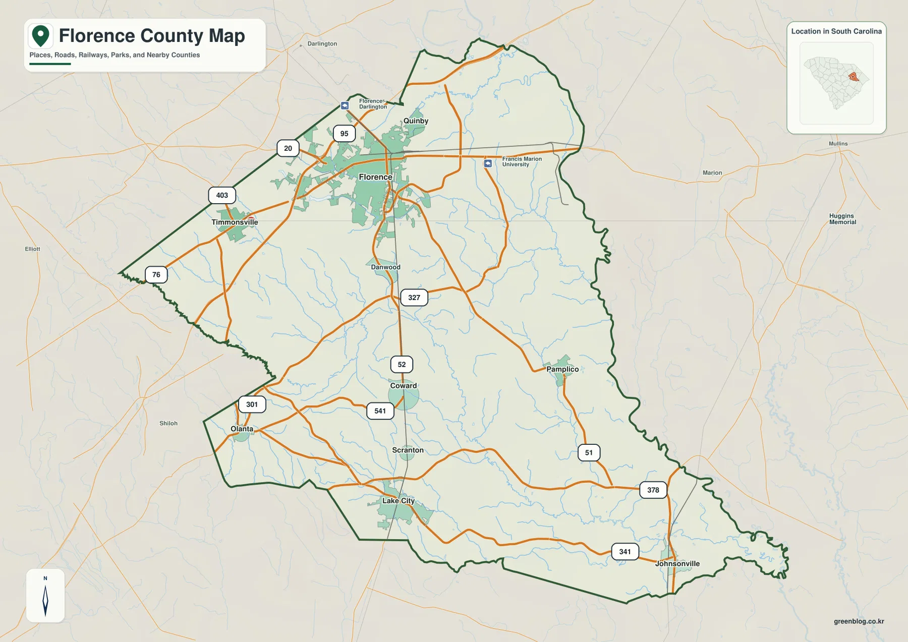
The map also shows institutional markers around the Florence area, including Francis Marion University and another Florence-Darlington reference. These symbols are most useful as location cues rather than a complete directory of facilities. Outside labels such as Darlington and Marion help orient the county within eastern South Carolina, but the important pattern remains inside the boundary: a busy north-central road hub and a set of smaller places spread toward the south, west, and east.
Six mapped places show how widely the county’s population centers are spread
The city map removes most road detail and emphasizes Florence, Lake City, Timmonsville, Johnsonville, Pamplico, and Quinby. Florence is the largest visual reference and sits in the north-central portion. Lake City lies far to the southwest, Johnsonville is near the southeastern end, Pamplico is east of center, Timmonsville is west of Florence, and Quinby is just northeast of Florence. This distribution makes it clear that the county is not organized around one compact cluster.
The CITY INDEX at the bottom ranks the same six places. The exact population figures are less important for this map guide than the positions they occupy. Florence and Quinby make a close northern pair, while Lake City and Johnsonville sit far apart along the southern half. Pamplico provides an eastern point and Timmonsville a western one. Those directions give readers a simple mental framework before they return to the more detailed road or water maps.
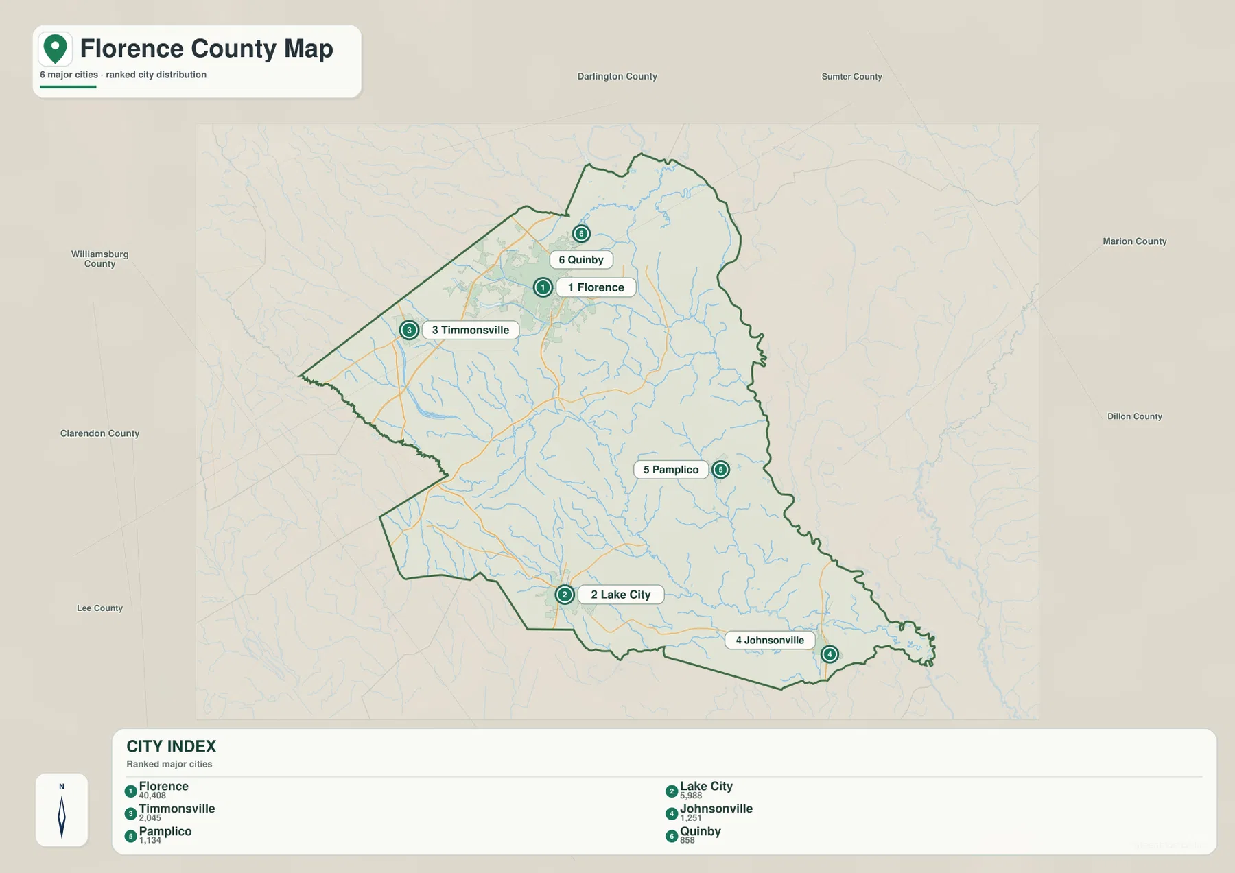
County names around the frame include Darlington, Sumter, Marion, Dillon, Clarendon, Lee, and Williamsburg. They show that Florence County meets several neighbors and has a boundary that stretches far enough to touch very different parts of eastern South Carolina. The long southeastern side and the stepped southwestern edge are much easier to recognize on this simplified map than on a dense road map.
The Lynches River becomes the main geographic line across the southern half
The terrain-and-water map changes the county’s visual emphasis almost completely. The Lynches River is the most prominent named waterway, running from the central-southern area toward the southeast in a long, winding course. Numerous tributaries join it from both sides. Without highway shields and large city labels, the river becomes a natural reference for the lower half of Florence County and helps explain why the southeastern boundary looks so irregular.
Black Creek is the strongest named stream in the north. Below it, Jeffries Creek and Long Branch cross the northern and northeastern interior, while Willow Creek appears farther southeast. On the western side, Oakdale Lake, Forest Lake, and Muldrus Pond provide small waterbody references. Sparrow Swamp and Lake Swamp are labeled farther south and west, and Big Swamp appears in the lower eastern half. The named features are distributed across the county rather than forming a single drainage corridor.
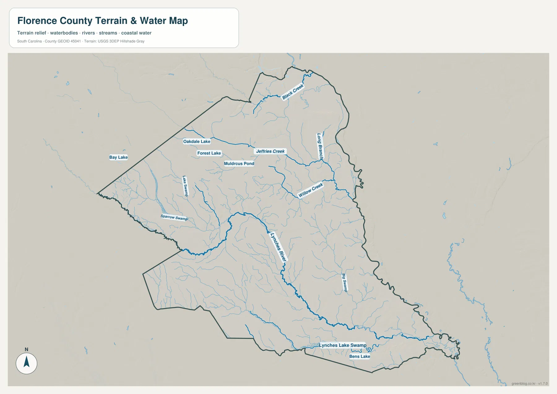
Near the southern edge, Lynches Lake Swamp and Bens Lake add more detail to the lower Lynches River area. The shaded background helps distinguish terrain visually, but the map does not provide exact elevation values. It should be used to locate rivers, creeks, lakes, ponds, and swamps, not as a flood-risk map, legal-boundary survey, or navigation chart.
A practical way to read the water map is to find the Lynches River and Black Creek first. Next, add Jeffries Creek, Willow Creek, and Long Branch, then look for the smaller named lakes and swamps. That order turns a dense web of blue lines into a manageable set of landmarks. When the water map is placed beside the road map, it also becomes easier to see where the main road corridors and drainage network cross one another.
Florence dominates the north, but the southern half carries a different set of landmarks
The supplied maps show a strong north-to-south contrast. Around Florence, the general map contains more roads, institutional markers, and developed-area shading than elsewhere in the county. Timmonsville and Quinby sit relatively close to that cluster. In the southern half, Lake City, Pamplico, and Johnsonville act as separate reference points, and the water network around the Lynches River becomes increasingly important.
The water map strengthens that contrast. Black Creek and smaller streams cross the north, but the Lynches River defines much of the lower county. Lake City occupies the southwest away from the river’s southeastern course, while Pamplico and Johnsonville lie closer to the eastern half where tributaries and swamp features are more visually prominent. The different maps therefore explain why a Florence-centered view alone would leave out important parts of the county.
The existing source package lists Florence as the county seat, a population of 137,059, 800 square miles of land, and a founding year of 1888. These figures are background facts rather than labels on the map images, but they provide useful scale when comparing Florence County with other South Carolina counties.
Choose the map based on whether roads, places, or waterways matter most
Use the general county map when the question is how Florence connects with Timmonsville, Lake City, Pamplico, Johnsonville, and the major numbered roads. The city map is cleaner when the main task is comparing the position of the six labeled places without road clutter. Choose the water map for the Lynches River, Black Creek, tributaries, lakes, ponds, and swamps. Since all three views use the same county boundary, they also work well side by side.
| General county map | Florence, Timmonsville, Lake City, Pamplico, Johnsonville, I-95, numbered roads, facilities, and the county boundary |
|---|---|
| City map | Relative positions of Florence, Lake City, Timmonsville, Johnsonville, Pamplico, and Quinby |
| Terrain and water map | Lynches River, Black Creek, Jeffries Creek, Willow Creek, lakes, ponds, swamps, and smaller tributaries |
- Start with the general map when road-based orientation around Florence is the main goal.
- Use the city map to compare how far Lake City, Johnsonville, Pamplico, Timmonsville, and Quinby sit from Florence and from one another.
- Use the water map when the Lynches River, Black Creek, named creeks, lakes, or swamps are the subject.
- For printing or classroom use, choose the high-resolution A3 JPG files in the ZIP rather than the smaller on-page WEBP previews.
Florence County details that are easy to miss on a small outline
Timmonsville is easy to miss if the eye stays on Florence, but it provides an important western reference near Routes 403 and 76. Quinby is much closer to Florence on the northeast side. Lake City sits near the southwestern boundary where Routes 301 and 541 are visible, while Pamplico lies in the eastern interior. Johnsonville is farther southeast near Routes 378 and 341. Those place-road pairings make the county much easier to navigate visually.
On the water map, Oakdale Lake and Forest Lake help identify the northwestern interior, with Muldrus Pond just to the east. Black Creek crosses the north, Jeffries Creek and Willow Creek help organize the middle, and the Lynches River draws the eye south and southeast. At the bottom, Lynches Lake Swamp and Bens Lake make the lower county distinct from the Florence urban area.
The road and water maps should not be read as if their lines represent the same kind of feature. Orange lines organize travel and connections between places, while blue lines identify rivers, creeks, and other water features. Comparing the two is useful precisely because they explain different parts of the county. Keeping those purposes separate also prevents the map guide from becoming a technical GIS report.
Frequently Asked Questions
Is Florence enough to orient the entire county?
Florence is the best starting point for the road network, but it does not represent the full county. Lake City is far to the southwest, Johnsonville is near the southeastern end, Pamplico is east of center, Timmonsville is to the west, and Quinby sits just northeast of Florence. The city map is the quickest way to compare all six positions.
Which waterways should I locate first?
Start with the Lynches River through the central-southern and southeastern county, then find Black Creek in the north. After those two anchors, Jeffries Creek, Willow Creek, Long Branch, Lynches Lake Swamp, and Bens Lake are much easier to place.
What files are included in the downloadable ZIP?
The archive contains high-resolution A3 JPG versions of the general county map, city map, and terrain-and-water map shown in the article. Each file can be printed separately or used with the others to compare roads, places, and waterways.
Map File Information
The ZIP contains the Florence County general map, city map, and terrain-and-water map shown on this page as high-resolution A3 JPG files. Use the individual files for printing, classroom material, reports, or side-by-side comparison.
- Included Files: General county map, city map, and terrain-and-water map
- File Type: Three high-resolution A3 JPG files in one ZIP archive
- Intended Use: Printing, education, presentations, and map-based projects
Related Maps
Sources and Reference Data
The official resources below provide reference material for county boundaries, county information, hydrography, and terrain. The specific place, road, river, creek, lake, pond, and swamp names discussed in the article are grounded in the supplied Florence County map images.
- South Carolina Association of Counties – County Information: county seat, population, and land area reference
- SCAC County Directory Pages: founding year and county background
- U.S. Census Bureau TIGER/Line Shapefiles: county boundary and geographic reference data
- USGS National Hydrography: rivers, streams, lakes, and waterbody reference data
- South Carolina Geological Survey: statewide geology and physical-geography reference material
Green Map creates custom-edited map images using open geographic data sources such as geoBoundaries, Natural Earth, OpenStreetMap, and government open data.
These maps are edited visual materials, not raw data files, and are provided for education, documents, presentations, and graphic reference.