Download the high-resolution A3 JPG files for this Fairfield County South Carolina Map in one ZIP archive. The WEBP previews on the page show the same three views at screen size. The general county map places Winnsboro, Winnsboro Mills, Ridgeway, and the main numbered roads inside the county boundary. The city-connections map uses Winnsboro as the hub and adds Ridgeway and Jenkinsville with straight-line distances. The water map brings Monticello Reservoir, the Little River, Little Wateree Creek, Big Wateree Creek, Dutchmans Creek, and the southern Cedar Creek network into clearer view.
Fairfield County becomes easier to understand when those layers are separated. Winnsboro provides a central road and administrative reference, Ridgeway sits to the southeast, and Jenkinsville appears to the southwest on the city map. Monticello Reservoir dominates the western water view, while the eastern half contains a denser collection of Wateree-related creeks and tributaries. A single outline would hide much of that contrast.
Table of Contents
Winnsboro organizes the central road network
On the general map, Winnsboro and Winnsboro Mills form the strongest central place labels. Route 34 and Route 200 meet in this area, and Route 321 descends from the north toward the town. A 321S shield appears farther south. The map also shows roads extending west, east, and southeast, which makes Winnsboro a practical starting point for understanding how the county is connected.
Ridgeway is easy to locate on the southeastern side near Route 21 and Route 77. Farther west, Routes 213 and 215 help identify the side of the county closer to the Monticello Reservoir area, while Route 269 marks part of the south. Route 901 and a 21N shield appear in the northeastern half. These labels are enough to understand the broad road structure without turning the page into a turn-by-turn street map.
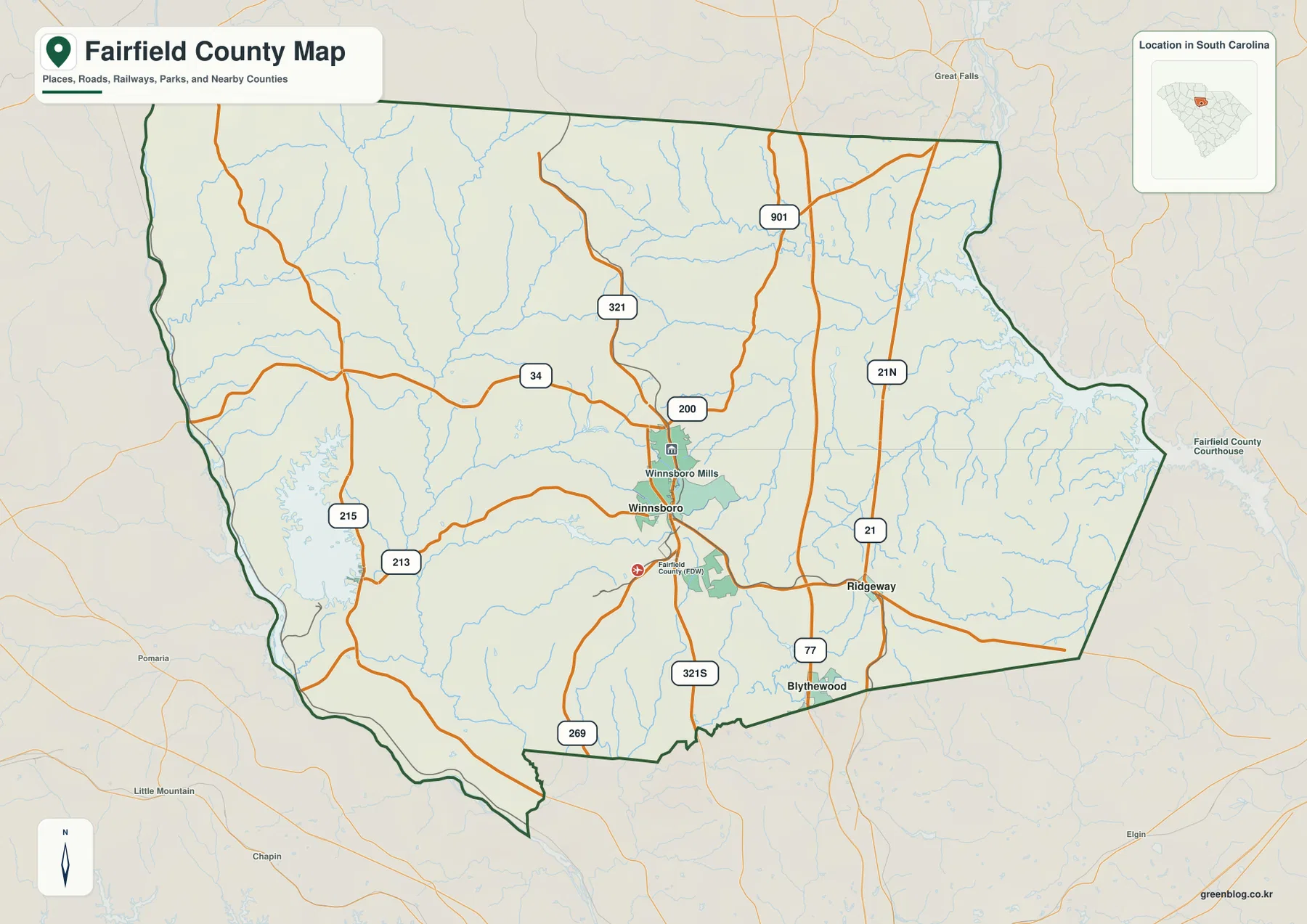
The general map also keeps many waterways visible as thin blue lines, so it provides an early hint of how strongly water features cross the county. Their names are not the focus of this view, however. The terrain-and-water map later in the article is better for identifying individual creeks and the Monticello Reservoir. This separation keeps the road map readable while still showing that roads and streams occupy the same landscape.
Ridgeway and Jenkinsville from the Winnsboro hub
The city-connections map simplifies the county to three named places. Winnsboro is the hub, Ridgeway lies to the southeast, and Jenkinsville is southwest of Winnsboro. The CITY CONNECTIONS panel gives Ridgeway at about 8 miles and Jenkinsville at about 11 miles from the hub. These figures are straight-line distances between the mapped points, not driving distances along roads.
That distinction matters because a road trip can be longer than the direct distance. The map is intended to show relative spacing and direction, not travel time. Ridgeway’s southeastern position and Jenkinsville’s southwestern position make the lower half of the county much easier to visualize than it would be with Winnsboro alone. The northern and eastern areas have fewer large place labels in this simplified view, so the general and water maps remain important for the full county picture.
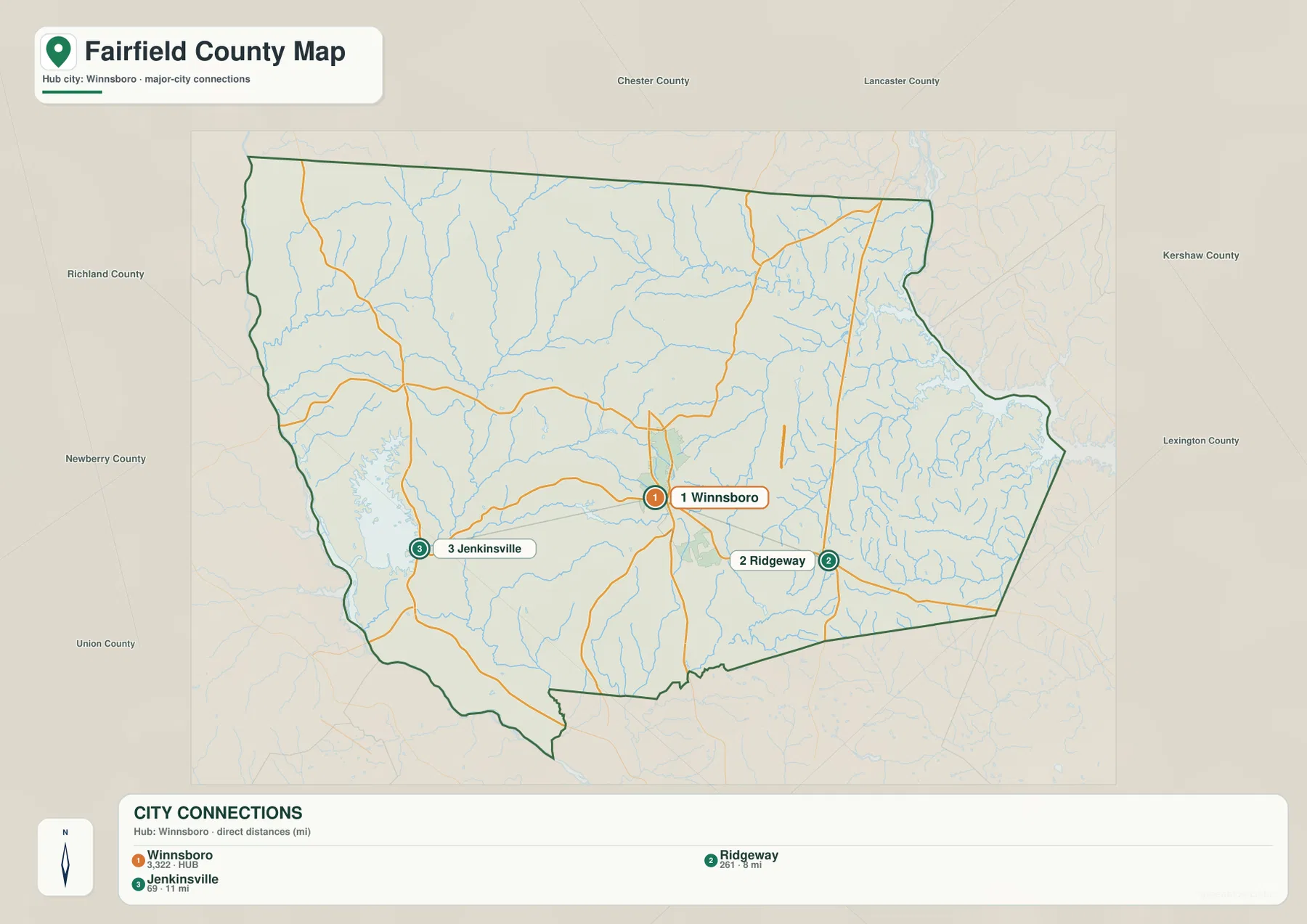
Names around the frame include Chester, Lancaster, Kershaw, Richland, Newberry, and Union counties. Those labels help position Fairfield County within central South Carolina and show that it spans a substantial east-west distance. They are orientation references rather than the main subject of the map, but they make the county’s location easier to understand without opening a separate statewide map.
Monticello Reservoir on the west, Wateree creeks on the east
The terrain-and-water map is anchored by Monticello Reservoir on the western side. It is the largest named waterbody visible within the county map and immediately gives the west a different appearance from the east. The Little River runs southward east of the reservoir, with Mill Creek and Morris Creek labeled nearby. The shaded relief background makes the drainage lines easier to see, but the map does not provide survey-grade elevation values.
In the northwestern part, McClures Creek and Beaver Creek are labeled along with West Fork. Moving east, Big Wateree Creek becomes a major named stream across the northern and northeastern interior. Little Wateree Creek runs through the central-eastern area toward the south, where Dutchmans Creek and numerous smaller tributaries connect around it. This is one of the clearest differences from the road map: the eastern half is organized visually by branching blue waterways rather than route shields.
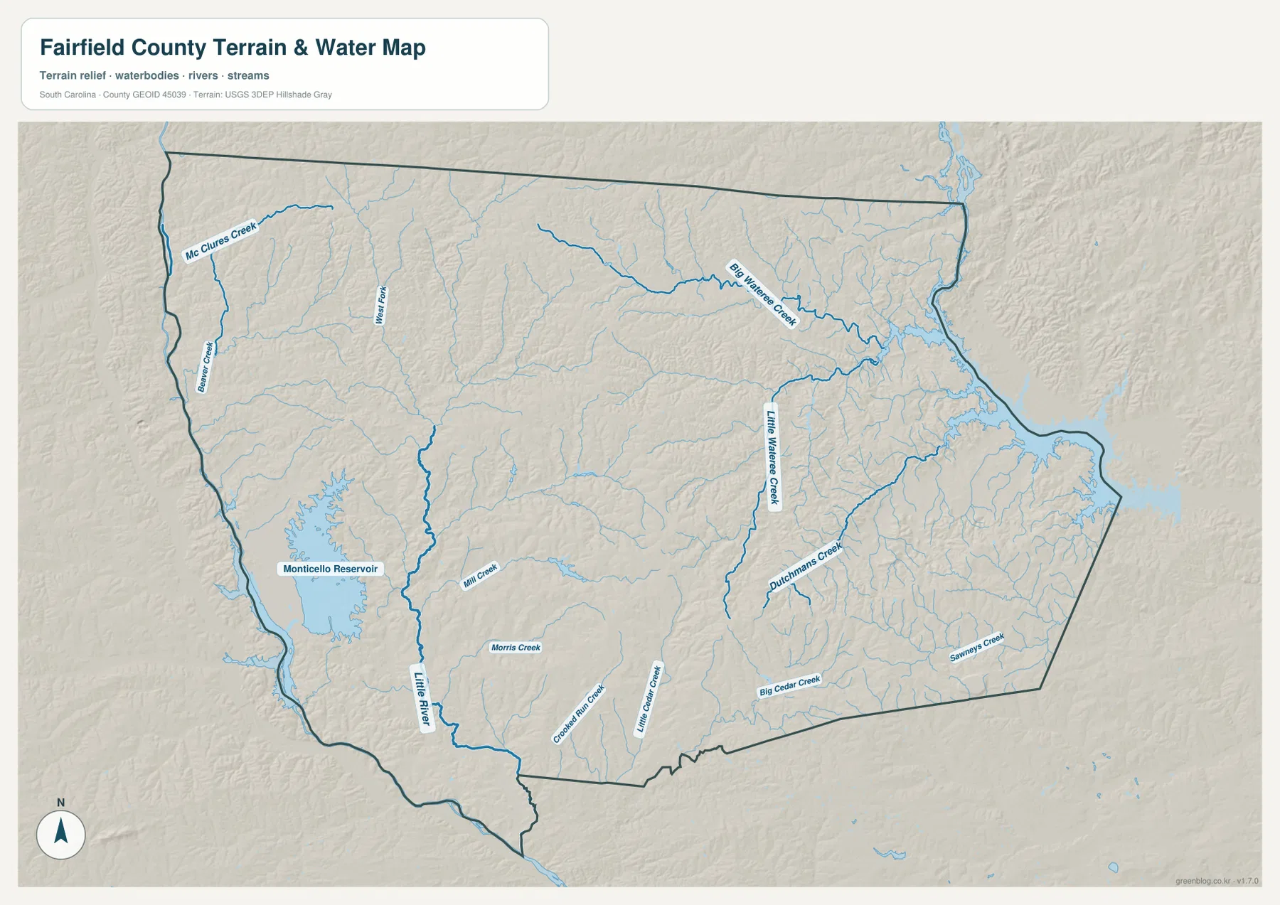
The southern half adds another group of named streams. Crooked Run Creek, Little Cedar Creek, and Big Cedar Creek are visible below the central part of the county, while Sawneys Creek appears farther southeast. Their locations show that the county’s drainage cannot be reduced to the reservoir or a single river system. Different named creeks define the west, east, and south.
This file is a water-reference and terrain-context map, not a flood-risk, parcel, legal-boundary, or navigation product. A practical reading order is to locate Monticello Reservoir first, follow the Little River south, then move across to Big and Little Wateree creeks and finally the Cedar Creek group near the southern boundary. That sequence makes the many smaller tributaries easier to place.
A large county is easier to grasp when roads, places, and water are separated
The supplied maps show why Fairfield County can feel different depending on the feature being emphasized. Winnsboro gives the road map a clear middle reference, but the city map adds two lower-county points in opposite directions. The water map shifts attention farther west to Monticello Reservoir and farther east to the Wateree creek network. None of those views replaces the others.
The current SCAC reference in the source package lists Fairfield County with 20,948 residents and 687 square miles of land, with Winnsboro as the county seat. The source package also gives a founding year of 1785. Those figures are background context rather than labels drawn on the maps, but they help explain why a county displayed at a fixed page size can make long road and water distances look shorter than they really are.
For that reason, the city map’s straight-line distances are useful anchors. Ridgeway at about 8 miles and Jenkinsville at about 11 miles from Winnsboro provide a simple sense of scale in the southern half. The road map and water map then extend the reader’s attention beyond those three points to the wider county boundary.
Match the map to the question you are trying to answer
Use the general county map for Winnsboro, Ridgeway, route numbers, and broad county orientation. Choose the city-connections map when the relative position of Winnsboro, Ridgeway, and Jenkinsville matters more than road detail. Use the water map for Monticello Reservoir, the Little River, the Wateree creeks, the Cedar creeks, and the smaller drainage network. Since all three views use the same county, they also work well side by side.
| General county map | Winnsboro, Ridgeway, Routes 21, 34, 77, 200, 213, 215, 269, 321, 901, and the county boundary |
|---|---|
| City-connections map | Winnsboro hub with Ridgeway about 8 miles and Jenkinsville about 11 miles away in straight-line distance |
| Terrain and water map | Monticello Reservoir, Little River, Wateree creeks, Cedar creeks, and smaller tributaries |
- Start with the general map for road-based orientation around Winnsboro and Ridgeway.
- Use the city-connections map when comparing Ridgeway and Jenkinsville from the Winnsboro hub.
- Use the water map when the subject is Monticello Reservoir or a named creek and its tributaries.
- For printing, use the high-resolution A3 JPG files in the ZIP rather than relying on the smaller on-page previews.
Fairfield County details that are easy to miss at first glance
Route 321 is one of the simplest lines to use when locating Winnsboro from the north. Route 21 and Route 77 help identify Ridgeway in the southeast, while Routes 213 and 215 provide western road references. Route 269 helps locate the lower boundary. These numbered roads turn a complex set of orange lines into a smaller group of useful landmarks.
On the water map, Monticello Reservoir is the obvious western anchor, but the Little River just to its east is equally useful for following the county southward. Big Wateree Creek and Little Wateree Creek define much of the eastern water view, while Big Cedar Creek and Little Cedar Creek help organize the lower section. Sawneys Creek gives the far southeast another named reference.
Jenkinsville is also important because it adds a western place reference that the older Winnsboro–Ridgeway framing did not emphasize. On the city map it sits southwest of the hub, and on the water map the western side is visually dominated by the reservoir and nearby streams. Seeing those together gives the western half a clearer identity without inventing a regional label that the supplied maps do not show.
Frequently Asked Questions
Are the Ridgeway and Jenkinsville distances driving distances?
No. The city-connections map shows straight-line distances from the Winnsboro hub: about 8 miles to Ridgeway and about 11 miles to Jenkinsville. Driving distances can be longer because they follow actual roads, so the figures should be used for relative geographic comparison.
Which water feature should I locate first?
Monticello Reservoir is the easiest starting point because it is the largest named waterbody on the map. From there, locate the Little River to the east, then Big Wateree Creek and Little Wateree Creek, followed by Big Cedar Creek and Little Cedar Creek near the southern part of the county.
What files are included in the download ZIP?
The archive contains high-resolution A3 JPG versions of the general county map, city-connections map, and terrain-and-water map shown in the article. Each file can be printed separately or used with the others to compare roads, selected places, and waterways.
Map File Information
The ZIP contains the Fairfield County general map, city-connections map, and terrain-and-water map shown on this page as high-resolution A3 JPG files. Use the individual files for printing, classroom material, reports, or side-by-side comparison.
- Included Files: 3 high-resolution A3 JPG maps described on this page
- File Type: JPG files in a ZIP archive
- Intended Use: Printing, education, presentations, and map-based projects
Related Maps
Sources and Reference Data
The official resources below provide reference material for county boundaries, county information, hydrography, and terrain. The specific road, place, reservoir, and creek names discussed in the article are grounded in the supplied Fairfield County map images.
- South Carolina Association of Counties – County Information: county seat, population, and land area reference
- SCAC County Directory Pages: founding year and county background
- U.S. Census Bureau TIGER/Line Shapefiles: county boundary and geographic reference data
- USGS National Hydrography: rivers, streams, reservoirs, and waterbody reference data
- South Carolina Geological Survey: statewide geology and physical-geography reference material
Green Map creates custom-edited map images using open geographic data sources such as geoBoundaries, Natural Earth, OpenStreetMap, and government open data.
These maps are edited visual materials, not raw data files, and are provided for education, documents, presentations, and graphic reference.