Download the high-resolution A3 JPG files for this Edgefield County Map in one ZIP archive. The WEBP previews on the page show the same three views at screen size. The general map places Edgefield, Johnston, Trenton, and the southern North Augusta direction beside numbered roads such as 23, 25, 121, 191, 230, 283, 378, and 430. The city-connections map uses Edgefield as the hub and shows straight-line distances to Johnston and Trenton. The water map shifts attention to Turkey Creek, Rock Creek, Beaverdam Creek, Horn Creek, Stevens Creek, and a scattered group of lakes and ponds.
Edgefield County has a broad northern half and a narrower southern extension. Edgefield sits near the middle of the main road network, Johnston lies to the east, and Trenton is southeast of Edgefield. The county boundary becomes more tapered toward the southern point near the North Augusta direction. Looking at the road, city, and water views together makes this shape easier to understand because each map removes some details and emphasizes a different set of landmarks.
Table of Contents
Edgefield and Johnston organize the central road network
The general county map gives Edgefield and Johnston the strongest place labels in the middle and eastern part of the county. Around Edgefield, Route 23, Route 25, Route 121, and Route 430 provide several orientation lines. Johnston is connected to the same central network, with Route 191 marked on the eastern side. Trenton appears farther south, where roads continue into the narrowing portion of the county.
The northern edge is crossed by Route 378, while Route 283 and Route 230 help identify the western side. Route 25 continues through the northern interior, and Route 121 is visible farther south. Near the county’s southern end, North Augusta and Murphys Estates appear as map labels that help show how far the boundary extends from the Edgefield–Johnston area. The map is most useful for broad county orientation rather than turn-by-turn navigation.
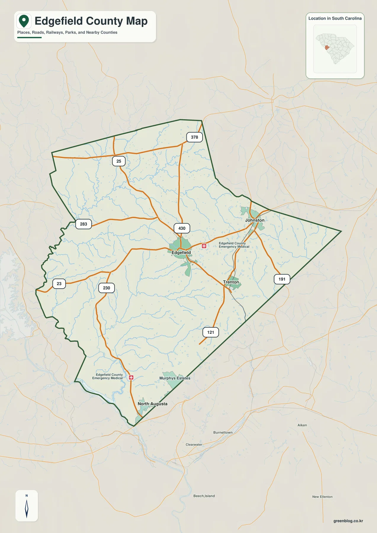
Emergency medical facility symbols are also shown near Edgefield and in the southern part of the county. They are useful visual references but should not be treated as a complete inventory of local services. Aiken appears outside the county to the southeast as a background place label. The important feature for this page is the arrangement inside Edgefield County: a central road focus around Edgefield, an eastern reference at Johnston, and a southern extension toward Trenton and the North Augusta side.
Johnston at about 8 miles and Trenton at about 6 miles from the Edgefield hub
The city-connections map simplifies the county by naming Edgefield as the hub and ranking Johnston and Trenton as the two connected places. The legend gives Johnston at about 8 miles and Trenton at about 6 miles from Edgefield. These are straight-line distances between the mapped points, not driving distances along roads. A vehicle route can be longer, so the figures are best used to compare relative spacing inside the county.
On the map itself, Johnston lies east of Edgefield and Trenton sits to the southeast. All three labels occupy the central-to-eastern side of the county rather than being evenly spread from border to border. That leaves large western and southwestern areas without a major city label on this simplified view, which is why the county and water maps are useful companions when the goal is to understand the full geographic extent.
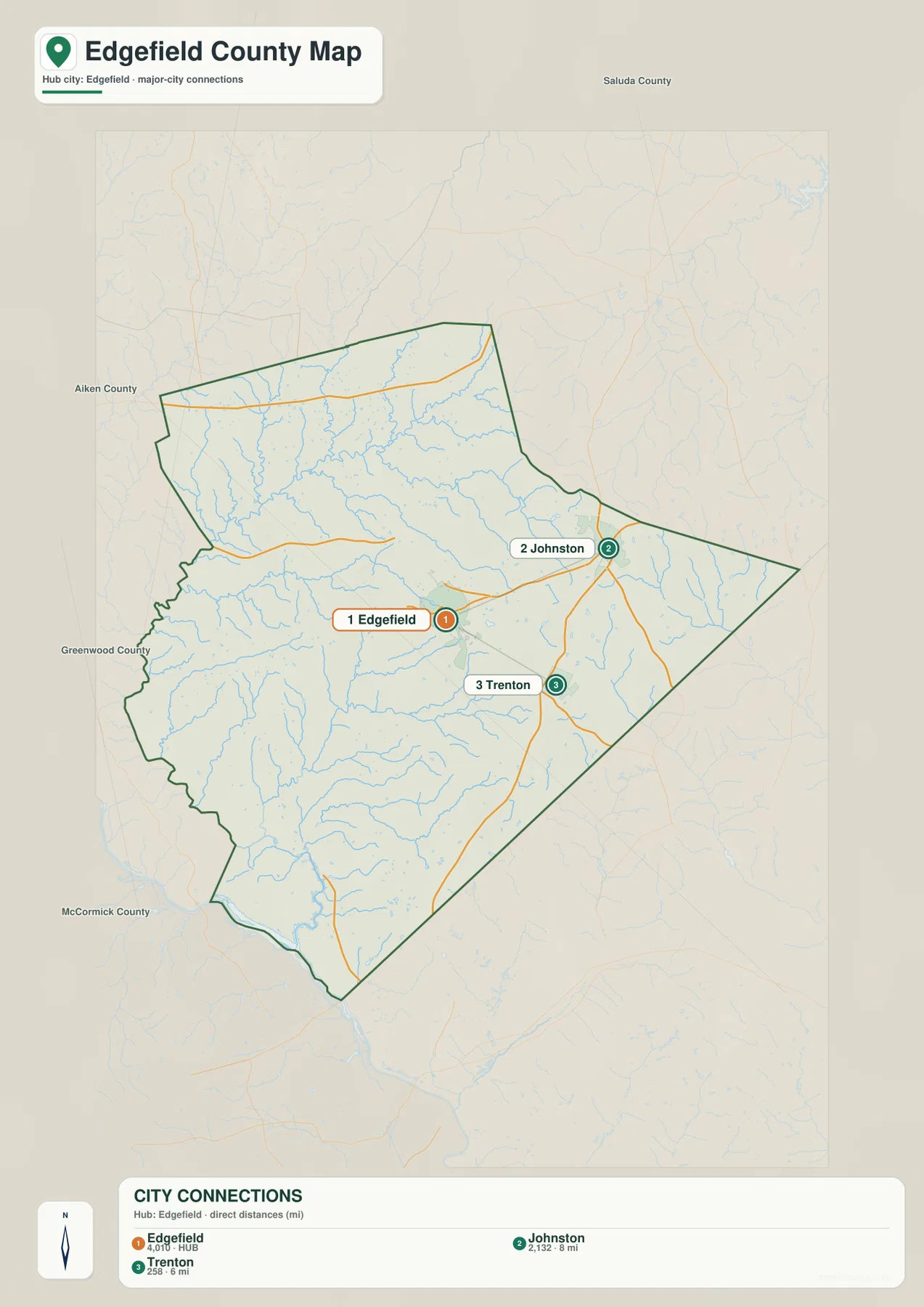
The surrounding county names also provide helpful orientation. Saluda County is labeled to the north, Aiken County to the east, Greenwood County to the west, and McCormick County to the southwest. Those labels show how Edgefield County fits into western South Carolina without requiring a separate statewide map. They also make the county’s east-west width easier to appreciate.
Turkey Creek and Rock Creek stand out across the northern water network
The terrain-and-water map looks very different from the road view. Turkey Creek is a prominent named channel running through the northwestern-to-central part of the county, and Rock Creek bends across the northern interior farther east. Numerous smaller tributaries feed into and cross the same area. Because road shields and city labels are mostly absent, the density of these smaller blue lines becomes much easier to see.
Several named waterbodies help divide the map into smaller reference areas. Gibson Pond and Holmes Pond are in the eastern half, Slade Lake is closer to the middle, and Long Pond sits farther southeast. Mathis Pond, Millers Pond, and Rainsford Pond appear across the central-to-southern interior. Lick Fork Lake is farther west. These names make the water map useful even when a reader is not following one continuous creek.
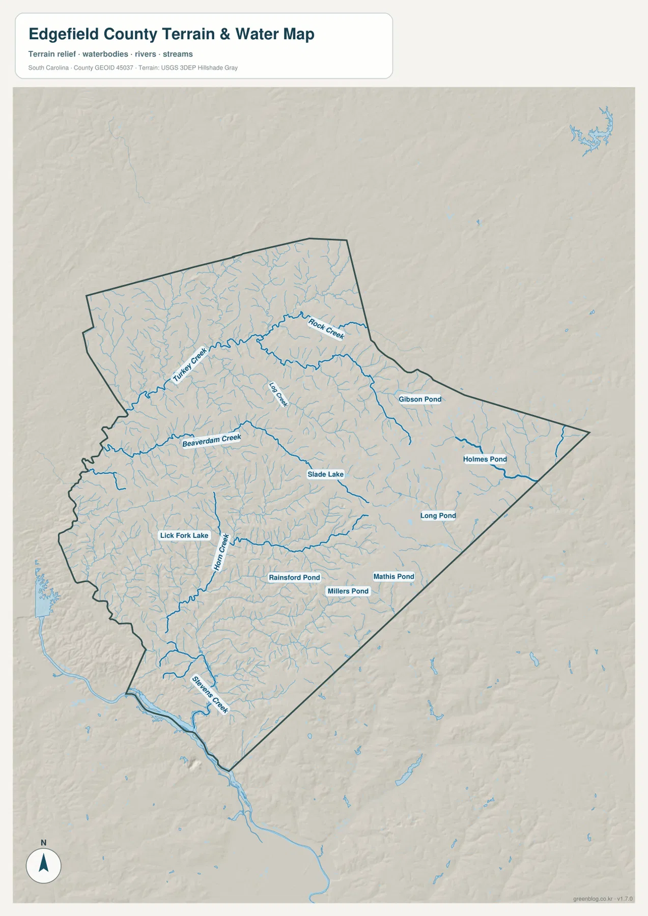
Beaverdam Creek crosses the central-western area, while Horn Creek runs through the southern half. Stevens Creek is labeled near the southwest, and Log Creek appears in the northern interior. Together, these features show that the county’s larger named waterways are distributed across several directions rather than concentrated in one corridor. The smaller tributaries fill many of the spaces between them.
The map uses shaded relief as a terrain background, but it does not provide precise elevation values. It should be treated as a reference for visible waterways and general terrain context, not as a flood-risk map, parcel map, legal-boundary survey, or navigation product. For detailed hydrography or engineering work, the official USGS sources listed later on the page are more appropriate.
A broad north and a tapered southern end
One of the easiest county-specific features to recognize is the way Edgefield County narrows toward the south. The northern half stretches widely from the western boundary toward Johnston and the eastern tip, while the southern section pulls inward toward the North Augusta direction. Edgefield and Johnston sit well above that narrow end, with Trenton positioned between the central cluster and the southern extension.
The water network reinforces that shape in a different way. Turkey Creek and Rock Creek occupy the broad northern half, Beaverdam Creek and Horn Creek cross the middle and south, and Stevens Creek is labeled near the southwestern side. Named ponds and lakes are scattered from east to west. The maps do not provide enough information to infer land use or development intensity from these patterns, but they do show how roads, settlements, and waterways occupy different parts of the same county boundary.
SCAC lists Edgefield County with a population of 25,657 and 502 square miles of land, and Edgefield is the county seat. The county’s founding year is listed as 1785. Those figures are supporting administrative context rather than map labels, but they give useful scale when this county is compared with other South Carolina counties.
Choose the view that matches the information you need
Use the general county map when the main question involves Edgefield, Johnston, Trenton, route numbers, or the county boundary. The city-connections map is cleaner when the goal is to compare the position of the three named places and the straight-line distances from the Edgefield hub. The water map is the better choice for Turkey Creek, Rock Creek, Beaverdam Creek, Horn Creek, Stevens Creek, and the named lakes and ponds.
| General county map | Edgefield, Johnston, Trenton, major numbered roads, southern North Augusta direction, and the county boundary |
|---|---|
| City-connections map | Edgefield hub with Johnston at about 8 miles and Trenton at about 6 miles in straight-line distance |
| Terrain and water map | Turkey Creek, Rock Creek, Beaverdam Creek, Horn Creek, Stevens Creek, lakes, ponds, and smaller tributaries |
- Start with the general map for road-based orientation and place names.
- Use the city-connections map when the relative spacing between Edgefield, Johnston, and Trenton matters more than road detail.
- Use the water map when the subject is a named creek, lake, pond, or the broader drainage network.
- For printing or classroom use, choose the high-resolution A3 JPG files in the ZIP rather than the smaller WEBP previews.
Small details that make the Edgefield maps easier to use
Route 430 is a useful central reference because it passes north of Edgefield and connects toward the Johnston side. Route 25 helps orient the northern interior, while Routes 23 and 230 identify parts of the west. Route 191 marks the eastern and southeastern side near Johnston. These numbered roads provide a simple framework before the reader begins following smaller local roads.
On the water map, Slade Lake is close enough to the center to work as a visual landmark. Gibson Pond and Holmes Pond help identify the east, while Lick Fork Lake sits farther west. Rainsford Pond, Millers Pond, Mathis Pond, and Long Pond are distributed across the central and southeastern interior. Their spacing shows why a water-focused map adds information that is not obvious on the road map.
The city and water maps should not be read as if they measure the same thing. The city map compares locations and straight-line distances among selected places; the water map shows named streams, lakes, ponds, and smaller tributaries. Using each file for its intended purpose keeps the county information clearer and avoids turning a simple reference map into something it was not designed to be.
Frequently Asked Questions
Are the Johnston and Trenton distances driving distances?
No. The city-connections map shows straight-line distances from the Edgefield hub: about 8 miles to Johnston and about 6 miles to Trenton. Driving distance depends on the road route and can be longer, so the map figures are best used for relative geographic comparison.
Which waterways are easiest to find first on the water map?
Start with Turkey Creek and Rock Creek in the northern half. Then locate Beaverdam Creek across the central-western area, Horn Creek farther south, and Stevens Creek near the southwest. Those larger labels make it easier to place the smaller tributaries and nearby lakes and ponds.
What files are included in the download ZIP?
The archive contains high-resolution A3 JPG versions of the general county map, city-connections map, and terrain-and-water map shown in the article. Each file can be printed separately or used with the others to compare roads, selected places, and waterways.
Map File Information
The ZIP contains the Edgefield County general map, city-connections map, and terrain-and-water map shown on this page as high-resolution A3 JPG files. Use the individual files for printing, classroom material, reports, or side-by-side comparison.
- Included Files: 3 high-resolution A3 JPG map files shown in this article
- File Type: JPG files in a ZIP archive
- Intended Use: Printing, education, presentations, and map-based projects
Related Maps
Sources and Reference Data
The official resources below provide reference material for county boundaries, county information, hydrography, and terrain. The specific road, place, creek, lake, and pond names discussed in the article are grounded in the supplied Edgefield County map images.
- South Carolina Association of Counties – County Information: county seat, population, and land area reference
- SCAC County Directory Pages: founding year and county background
- U.S. Census Bureau TIGER/Line Shapefiles: county boundary and geographic reference data
- USGS National Hydrography: rivers, streams, and waterbody reference data
- South Carolina Geological Survey: statewide geology and physical-geography reference material
Green Map creates custom-edited map images using open geographic data sources such as geoBoundaries, Natural Earth, OpenStreetMap, and government open data.
These maps are edited visual materials, not raw data files, and are provided for education, documents, presentations, and graphic reference.