Download the high-resolution A3 JPG files for this Dorchester County South Carolina Map in one ZIP archive. The WEBP previews on the page show the same three views at a convenient screen size. Together, the maps follow a county that stretches from St. George, Reevesville, and Harleyville in the northwest to Summerville and North Charleston in the southeast. The general map highlights I-95, I-26, and other numbered roads; the city map simplifies the settlement pattern; and the water map brings Four Hole Swamp, the Edisto River, the Ashley River, smaller swamps, creeks, and lakes into focus.
Dorchester County has a shape that makes orientation easier when several maps are viewed together. Its northwestern portion is broad, with smaller places spread across a relatively open area, while the county narrows and becomes more visually complex toward Summerville and North Charleston. That southeastern end contains more road detail and a denser developed pattern on the general map. The water map adds another layer: Four Hole Swamp and the Edisto River occupy the middle of the county, while the Ashley River appears near the southeastern end.
Table of Contents
St. George anchors the northwestern road pattern
On the general map, St. George is the clearest reference point in the northwestern half of Dorchester County. Reevesville lies to its west and Harleyville to the east, while Grover appears farther south. Route 15 runs through this part of the county and Route 178 crosses the St. George area. I-95 is marked near the western edge, giving the map an easy north-south reference before the county begins to narrow toward the southeast.
The road network changes as the map moves east and south. I-26 and Route 27 cross the central portion, with Ridgeville placed nearby. Route 78 continues toward the southeast, and Routes 17A and 61 are shown closer to Summerville and North Charleston. Route 165 appears near the southern edge. The result is a map that becomes progressively busier toward the southeastern communities, which is useful for understanding why the county does not have a single uniform road pattern.
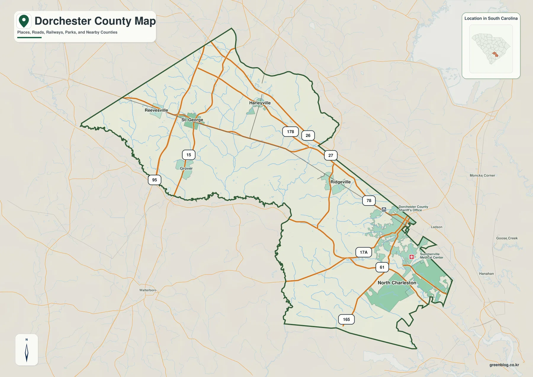
A few public facilities are also marked around the southeastern cluster, including the Dorchester County Sheriff’s Office and Summerville Medical Center. Those labels reinforce how much more urban detail appears near Summerville than around the smaller northwestern places. Nearby names outside the county frame, including Moncks Corner, Goose Creek, Hanahan, and Walterboro, help with orientation but are not the subject of the map. The main value is the county’s internal contrast between the broad northwest and the busier southeast.
The city map separates the southeastern cluster from the smaller northwest
The city map removes much of the road detail and ranks six mapped places: North Charleston, Summerville, St. George, Ridgeville, Harleyville, and Reevesville. North Charleston and Summerville are positioned at the southeastern end, close to the narrow portion of the county boundary. Ridgeville sits farther northwest along the transition zone. St. George, Harleyville, and Reevesville occupy the broad upper part of the county, where the spacing between labeled places is much greater.
The CITY INDEX at the bottom also gives North Charleston and Summerville the largest entries, followed by St. George, Ridgeville, Harleyville, and Reevesville. For this article, the most useful information is not the exact ranking number but the geographic arrangement it represents. The two largest labels sit far from the three smaller northwestern places, which makes the county’s split character easy to recognize at a glance.
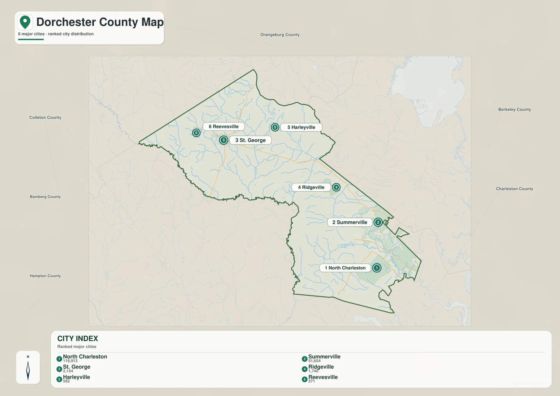
County names around the map frame include Orangeburg, Berkeley, Charleston, Colleton, and others, giving a wider South Carolina reference. The southeastern communities are visibly close to the Charleston and Berkeley side of the map, while St. George and Reevesville sit well inland. This is why the city view is useful even after the general road map has been studied: it removes highway shields and lets the reader compare the spacing and direction of the main labeled places without distraction.
Four Hole Swamp and the Edisto River define the middle of the water map
The terrain-and-water map shifts attention away from cities and roads. Four Hole Swamp is the most prominent named feature through the middle of the county, with a network of smaller blue lines feeding and crossing the area. Indian Field Swamp appears farther west, while Huttos Lake is marked in the northwestern interior. The Edisto River is labeled below Four Hole Swamp, creating a clear water reference between the broad northwestern section and the narrower southeastern section.
Moving southeast, the map shows Great Cypress Swamp and Rumphs Hill Creek along with several smaller channels. Robs Lake and Schultz Lake are labeled in the central-southeastern area. These features help explain why the blue network becomes visually denser even before the map reaches the Ashley River. Rather than one dominant river crossing the entire county, Dorchester County is shown with a combination of swamps, branches, creeks, and small lakes that connect different parts of the interior.
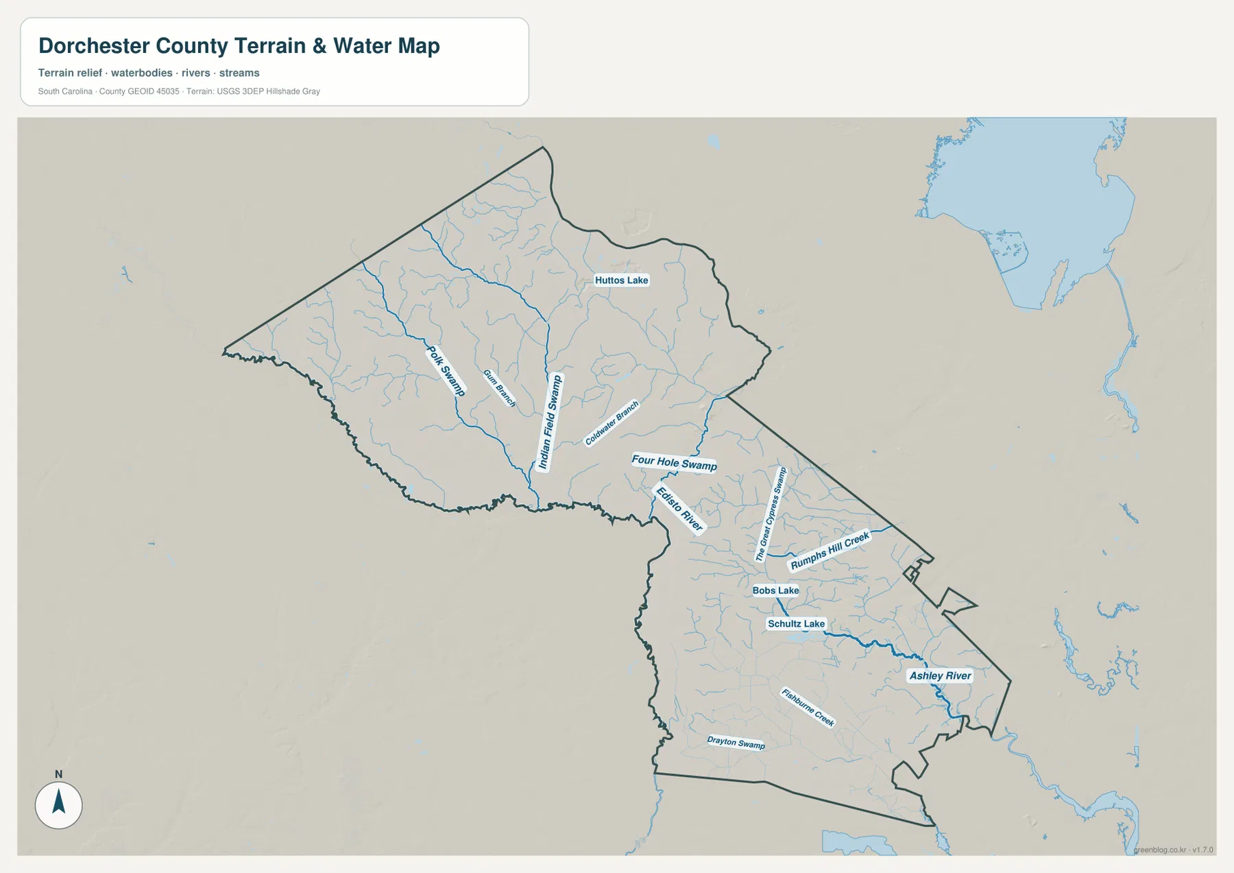
The Ashley River is the strongest named water feature near the southeastern end of the county. Its position becomes especially meaningful when compared with the city map, because Summerville and North Charleston occupy the same general end of the county where the water network is more intricate. Drayton Swamp is also labeled in the southern part. Reading these names together shows that the southeastern portion is not only the more urban part of the county but also an area crossed by numerous waterways.
This water map is a reference for visible rivers, swamps, creeks, and lakes; it is not a flood-risk, parcel, legal-boundary, or navigation product. A practical way to use it is to locate Four Hole Swamp first, then trace the Edisto River below it and the Ashley River toward the southeast. After those larger names are found, Indian Field Swamp, Great Cypress Swamp, Huttos Lake, Robs Lake, Schultz Lake, and smaller channels are easier to place.
One county, two very different visual regions
The clearest county-specific pattern in the supplied maps is the contrast between the northwest and southeast. Around St. George, Reevesville, and Harleyville, the boundary encloses a broad area with relatively few prominent place labels. The general map shows a handful of major numbered routes crossing that space. Near Summerville and North Charleston, the county narrows, road detail increases, developed areas become more visible, and public-facility symbols appear. The change is obvious without relying on abstract regional labels.
The water map gives that contrast another dimension. Huttos Lake and several swamps and tributaries appear in the northwest, while Four Hole Swamp and the Edisto River organize the middle of the county. The southeastern section contains the Ashley River, several smaller channels, and more detailed water features. Roads and waterways therefore do not simply repeat the same pattern: each map explains a different part of how the county is arranged.
Ridgeville is useful as a middle reference because it sits between the broad St. George side and the more urban Summerville side. On the road map, I-26 and nearby routes pass through the central-to-southeastern corridor. On the city map, Ridgeville is visually separated from both clusters. This makes it a helpful landmark when describing how the county gradually changes rather than treating the northwest and southeast as two completely disconnected pieces.
Which Dorchester County map should you use?
Use the general county map when the main question involves St. George, Summerville, North Charleston, Ridgeville, or the route pattern connecting them. The city map is cleaner for comparing the position of the six ranked places without the distraction of road shields. Choose the water map when Four Hole Swamp, the Edisto River, Ashley River, or the smaller swamps and lakes are the subject. Because all three use the same county boundary, they can also be placed side by side for a quick road-versus-settlement-versus-water comparison.
| General county map | St. George, Summerville, North Charleston, I-95, I-26, numbered roads, facilities, and surrounding place references |
|---|---|
| City map | Relative positions of North Charleston, Summerville, St. George, Ridgeville, Harleyville, and Reevesville |
| Terrain and water map | Four Hole Swamp, Edisto River, Ashley River, Indian Field Swamp, lakes, creeks, and smaller waterways |
- Start with the general map for road-based orientation between St. George and Summerville.
- Use the city map to compare the southeastern North Charleston–Summerville cluster with the smaller northwestern places.
- Use the water map for Four Hole Swamp, the Edisto and Ashley rivers, or the distribution of swamps and lakes.
- For printing, use the high-resolution A3 JPG files in the ZIP rather than relying on the smaller on-page previews.
Details worth noticing before you download
St. George and Summerville make a useful pair of reference points because they occupy very different parts of the county. St. George helps organize the broad northwestern side and the smaller communities around it. Summerville marks the more urban southeastern side, where the county boundary is narrower and more road detail appears. Ridgeville lies between those areas, making it easier to follow the transition across the county.
The water names are also easier to remember when tied to those locations. Four Hole Swamp occupies the middle of the county, the Edisto River is labeled just below it, and the Ashley River sits near the southeastern end. Huttos Lake belongs to the broad northwestern interior, while Robs Lake and Schultz Lake are closer to the southeastern half. Those landmarks give the water map a simple sequence even though many smaller blue lines are present.
Dorchester County is therefore best understood as a long county with different kinds of reference points depending on where the reader looks. Roads and smaller communities dominate the northwestern orientation; major cities and more detailed road networks dominate the southeast; and waterways cut across both. The separate map files keep those layers readable rather than forcing every label onto a single crowded image.
Frequently Asked Questions
How are St. George and Summerville positioned within Dorchester County?
St. George is in the broad northwestern part of the county near Reevesville and Harleyville, while Summerville is much farther southeast near North Charleston. The general map shows the road corridor between the two areas, and the city map makes the separation easier to compare because most highway detail has been removed.
Which water features should I locate first?
Start with Four Hole Swamp in the middle of the county, then find the Edisto River below it and the Ashley River near the southeastern end. Once those three large references are located, Indian Field Swamp, Great Cypress Swamp, Huttos Lake, Robs Lake, Schultz Lake, and smaller channels are easier to place.
What is included in the downloadable ZIP?
The archive contains high-resolution A3 JPG versions of the general county map, city map, and terrain-and-water map shown in the article. Each file can be printed separately or used with the others to compare roads, settlements, and waterways within the same county boundary.
Map File Information
The ZIP contains the Dorchester County general map, city map, and terrain-and-water map shown on this page as high-resolution A3 JPG files. Use the individual files for printing, classroom material, reports, or side-by-side comparison.
- Included Files: general, city, and terrain-and-water maps shown in this article
- File Type: High-resolution A3 JPG files
- Intended Use: Printing, education, presentations, and map-based projects
Related Maps
Sources and Reference Data
The official resources below provide reference material for county boundaries, county information, hydrography, and terrain. The specific place, road, river, swamp, and lake names discussed in the article are grounded in the supplied Dorchester County map images.
- South Carolina Association of Counties – County Information: county background and administrative reference
- U.S. Census Bureau TIGER/Line Shapefiles: county boundary and geographic reference data
- USGS National Hydrography: rivers, streams, and waterbody reference data
- USGS 3D Elevation Program: terrain and elevation reference data
- South Carolina Geological Survey: statewide geology and physical-geography references
Green Map creates custom-edited map images using open geographic data sources such as geoBoundaries, Natural Earth, OpenStreetMap, and government open data.
These maps are edited visual materials, not raw data files, and are provided for education, documents, presentations, and graphic reference.