Download the high-resolution A3 JPG files for this Dillon County Map in one ZIP archive. The WEBP previews on the page show the same three map views: a general county map with roads and places, a city-connections map centered on Dillon, and a terrain-and-water map organized around the Little Pee Dee River. Together they make it easy to compare Dillon with Latta and Lake View, follow I-95 and the numbered state and U.S. routes, and then switch from the road network to the creeks and swamps that shape the county’s drainage.
Dillon County has a distinctive outline on these maps. The northern tip is narrow and pointed, the county broadens around Dillon, and the southern half spreads toward Latta on the southwest and Lake View on the southeast. Dillon sits near the main concentration of mapped roads, with Little Rock and Hamer just to the north. On the water map, however, the Little Pee Dee River becomes the strongest visual feature, running from the northern part of the county through the center and bending toward the south.
Table of Contents
Roads radiating from Dillon toward Latta and Lake View
The general map is easiest to read by starting at Dillon. Route 34 crosses the central area, Route 57 extends south, and several other roads branch toward nearby communities. Little Rock and Hamer sit just north of Dillon, while Newtown lies immediately to the south. Farther southwest, Latta is surrounded by shields for U.S. 501, U.S. 301, and Route 38. I-95 appears at the southwestern edge of the county, making that corner visually different from the more local road pattern around Dillon.
Lake View forms the main eastern reference point. Route 41 reaches the town from the west and northwestern side, while Route 9 is marked south of Lake View near the county’s southeastern section. Floydale appears between Dillon and the southern boundary, and the map also shows outside reference places such as Sellers, Nichols, Clio, and Blenheim. Those outside names help with orientation, but the county’s internal pattern is clearer: Dillon in the middle, Latta toward the southwest, and Lake View toward the east.
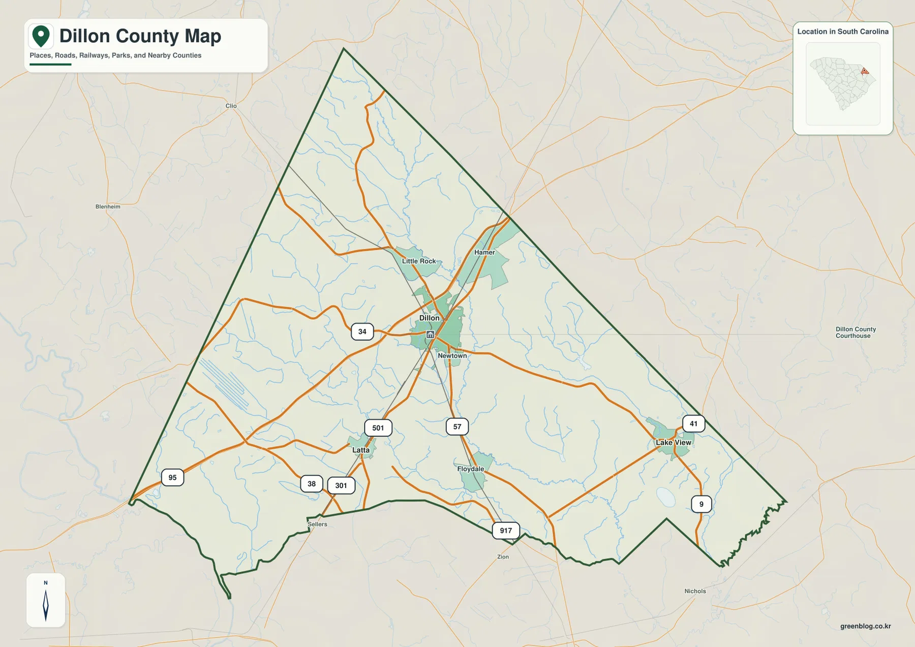
The county outline explains why the road pattern looks fan-shaped. North of Dillon, the county narrows considerably. South of Dillon, the boundary widens, allowing routes to spread toward Latta and Lake View in different directions. The southeastern edge also becomes more irregular, while the southwestern corner is easy to recognize because I-95 enters near the point of the boundary. Reading the roads together with the outline is more informative than treating the route numbers as an isolated list.
Dillon, Latta, and Lake View: direction matters as much as distance
The city-connections map simplifies the county and highlights only Dillon, Latta, and Lake View as ranked reference places. Dillon is the hub. Latta is plotted southwest of it, and Lake View is farther to the southeast. The map gives straight-line distances from Dillon: about 7 miles to Latta and about 13 miles to Lake View. These are not driving distances. They are direct point-to-point measurements intended to show relative spacing and should not be used as route mileage.
The difference between the two directions is important. Latta lies closer to the I-95 and U.S. 301/501 side of the county, so it belongs to the southwestern road pattern. Lake View is closer to the eastern boundary and the Route 41 and Route 9 corridor. Dillon sits between them and also connects northward toward Little Rock and Hamer. The city map therefore turns a busy county map into a simple triangle of reference points, which is useful when a reader wants to understand where the county’s principal labeled places sit before looking at the detailed road network.
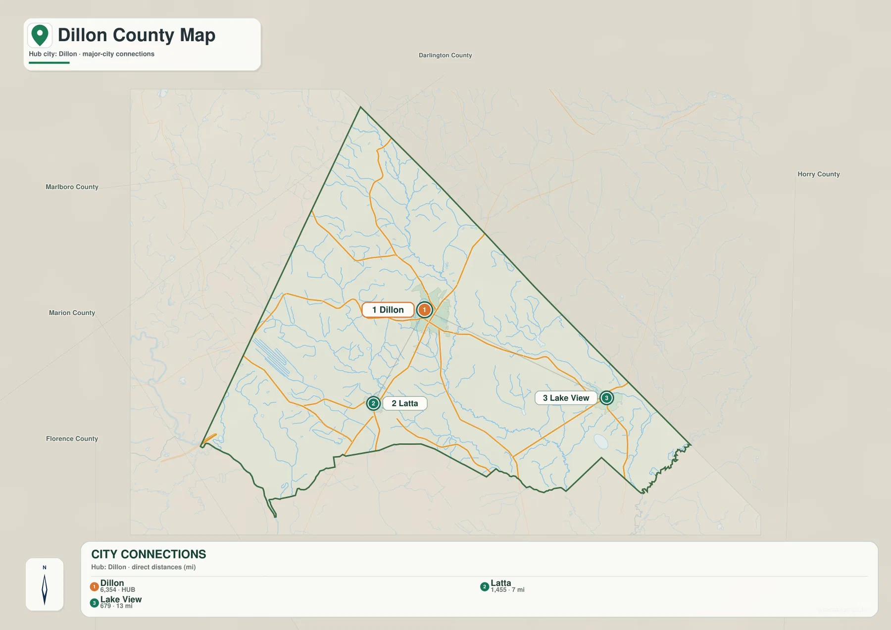
Neighboring county names around the frame add broader context. Marlboro County appears to the northwest, Darlington County to the north, Florence and Marion counties to the west and southwest, and Horry County to the east. Those labels show Dillon County’s position in northeastern South Carolina without crowding the county itself with extra detail. For most readers, the useful takeaway is the relationship among the three internal places and the fact that Lake View is almost twice as far from Dillon as Latta is in straight-line terms.
The Little Pee Dee River becomes the county’s main landmark on the water map
The terrain-and-water map changes the emphasis completely. The Little Pee Dee River is the most prominent named watercourse, descending from the northern portion of Dillon County, passing through the central area, and continuing toward the south. Its thicker blue line gives the county a natural internal reference that is largely hidden by the road symbols on the general map. Smaller waterways then make more sense because they can be read in relation to the river rather than as disconnected blue lines.
On the western side, Reedy Creek and Little Reedy Creek are clearly labeled. Beaverdam Creek and Millers Branch appear farther north and northwest. Bear Swamp extends across the eastern half, while Buck Swamp is labeled closer to the southern boundary. Hayes Swamp is also shown near the upper-central portion east of the Little Pee Dee River. These names make the water map county-specific: Dillon County is not represented by a generic river symbol, but by a network of creeks, branches, and swamps arranged around one major river.
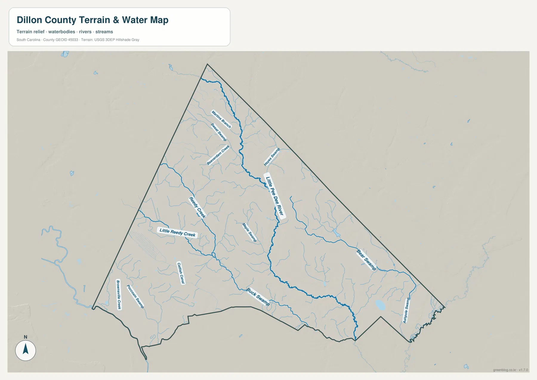
The southeastern edge is especially intricate, with many smaller channels approaching the irregular boundary near the Lake View side of the county. The north is easier to trace because the river and its upper tributaries form longer, cleaner lines. In the southwest, Reedy Creek, Little Reedy Creek, and Buck Swamp make a separate group of named features. This contrast is useful when comparing the water map with the general map: the roads make Dillon and Latta the obvious anchors, while the water map shifts attention to the central river and the branching drainage network.
This is a reference map for the location of mapped water features, not a flood-risk, property, depth, or navigation product. It does not say whether a stream is navigable, how deep it is, or how far floodwater could extend. Its value is simpler and more reliable: it shows where the Little Pee Dee River and several named creeks and swamps are positioned within the county boundary.
Choosing between roads, city spacing, and waterways
The three files work best when each is used for a specific question. The general county map is the clearest choice for road numbers, communities, and the relationship between Dillon, Latta, Lake View, Little Rock, and Hamer. The city-connections map is intentionally simpler and is useful when the main question is distance and direction from Dillon. The terrain-and-water map is the better choice for the Little Pee Dee River, Reedy Creek, Bear Swamp, and the other named water features.
| General county map | Dillon, Latta, Lake View, Little Rock, Hamer, I-95, and major numbered roads including 34, 41, 57, 301, and 501 |
|---|---|
| City-connections map | Dillon as the hub; Latta about 7 miles and Lake View about 13 miles away by straight-line distance |
| Terrain and water map | Little Pee Dee River, Reedy Creek, Little Reedy Creek, Beaverdam Creek, Bear Swamp, Buck Swamp, and other waterways |
For a printed report, it is usually better to select the map that matches the subject rather than trying to force every label into a single image. A transportation section needs the road map. A short county-location comparison may need only the city map. A natural-resources section is easier to read with the water map because route shields and community labels do not compete with the stream network. Since all three use the same county boundary, they can also be placed side by side without changing the geographic frame.
- Use the general map first when tracing the I-95 side of the county or comparing Route 34 through Dillon with Routes 41 and 9 near Lake View.
- Use the city-connections map when comparing Dillon, Latta, and Lake View, and remember that the displayed mile values are straight-line distances.
- Use the water map by finding the Little Pee Dee River first, then moving outward to Reedy Creek, Beaverdam Creek, Bear Swamp, and Buck Swamp.
- Use the downloadable A3 JPG files when small road shields or thin water lines need to remain legible in print.
A narrow northern tip, a wider southern half, and two different ways to read the county
Dillon County’s outline is one of the reasons the three maps complement one another so well. The narrow northern tip contains fewer large place labels and is visually dominated by water lines and the routes descending toward Dillon. The middle broadens around Dillon, where roads and developed-area shading are most noticeable. The southern half spreads in two directions: Latta occupies the southwestern side, while Lake View sits near the eastern edge. That geometry gives the county a strong center without making every part of the map feel centered on the same place.
The southwest and southeast also contrast with one another. The I-95 shield and the cluster of U.S. 301/501 around Latta make the southwest easy to identify on the general map. Around Lake View, Route 41 and Route 9 define the road context, but the water map shows a denser set of small channels near the irregular southeastern boundary. This is a useful example of why one map cannot answer every question: the same corner that looks road-oriented in one view can look water-oriented in another.
The north-central area presents another contrast. Little Rock and Hamer are close to Dillon on the road map, yet the water map emphasizes Millers Branch, Beaverdam Creek, Hayes Swamp, and the upper reach of the Little Pee Dee River instead. Switching between the two views helps a reader connect named communities with the natural drainage pattern without pretending that the map provides parcel-level or street-level detail.
For a county profile, this combination is more useful than a bare boundary image. The maps show where the main named places sit, how the numbered road network spreads from Dillon, how Latta and Lake View differ in direction and distance, and where the Little Pee Dee River and its tributaries lie. Those are concrete, map-visible features that make the page specific to Dillon County rather than a generic description that could be reused for another county.
Frequently Asked Questions
Are the Dillon-to-Latta and Dillon-to-Lake View mile values driving distances?
No. The city-connections map uses straight-line distance from Dillon. Latta is shown at about 7 miles and Lake View at about 13 miles. Actual road mileage can be longer and depends on the route and the specific start and end points.
What is the easiest water feature to find first on the Dillon County water map?
Start with the Little Pee Dee River. It is the most prominent named blue line and runs from the northern part of the county through the center toward the south. Once it is located, Reedy Creek, Little Reedy Creek, Beaverdam Creek, Bear Swamp, and Buck Swamp are easier to place around it.
Which side of Dillon County is I-95 shown on?
I-95 is shown at the southwestern edge of the county, closer to the Latta side than to Lake View. The same area also includes U.S. 301, U.S. 501, and Route 38, so the southwest has a noticeably different road pattern from the eastern side around Lake View.
Map File Information
The ZIP contains the three Dillon County maps shown on this page as high-resolution A3 JPG files: the general county map, city-connections map, and terrain-and-water map.
- Included Files: The map files described and shown on this page
- File Type: JPG map files packaged in a ZIP archive
- Intended Use: Printing, education, presentations, and map-based projects
Related Maps
Sources and Reference Data
The place, road, and water-feature descriptions above are grounded in the supplied Dillon County map images. The following authoritative sources are useful for checking county boundaries and broader geographic data.
- South Carolina Association of Counties – County Information: county background and administrative reference
- U.S. Census Bureau TIGER/Line Shapefiles: county boundary and geographic reference data
- USGS National Hydrography: rivers, streams, and waterbody reference data
- South Carolina Geological Survey: statewide geology and physical-geography reference
Green Map creates custom-edited map images using open geographic data sources such as geoBoundaries, Natural Earth, OpenStreetMap, and government open data.
These maps are edited visual materials, not raw data files, and are provided for education, documents, presentations, and graphic reference.