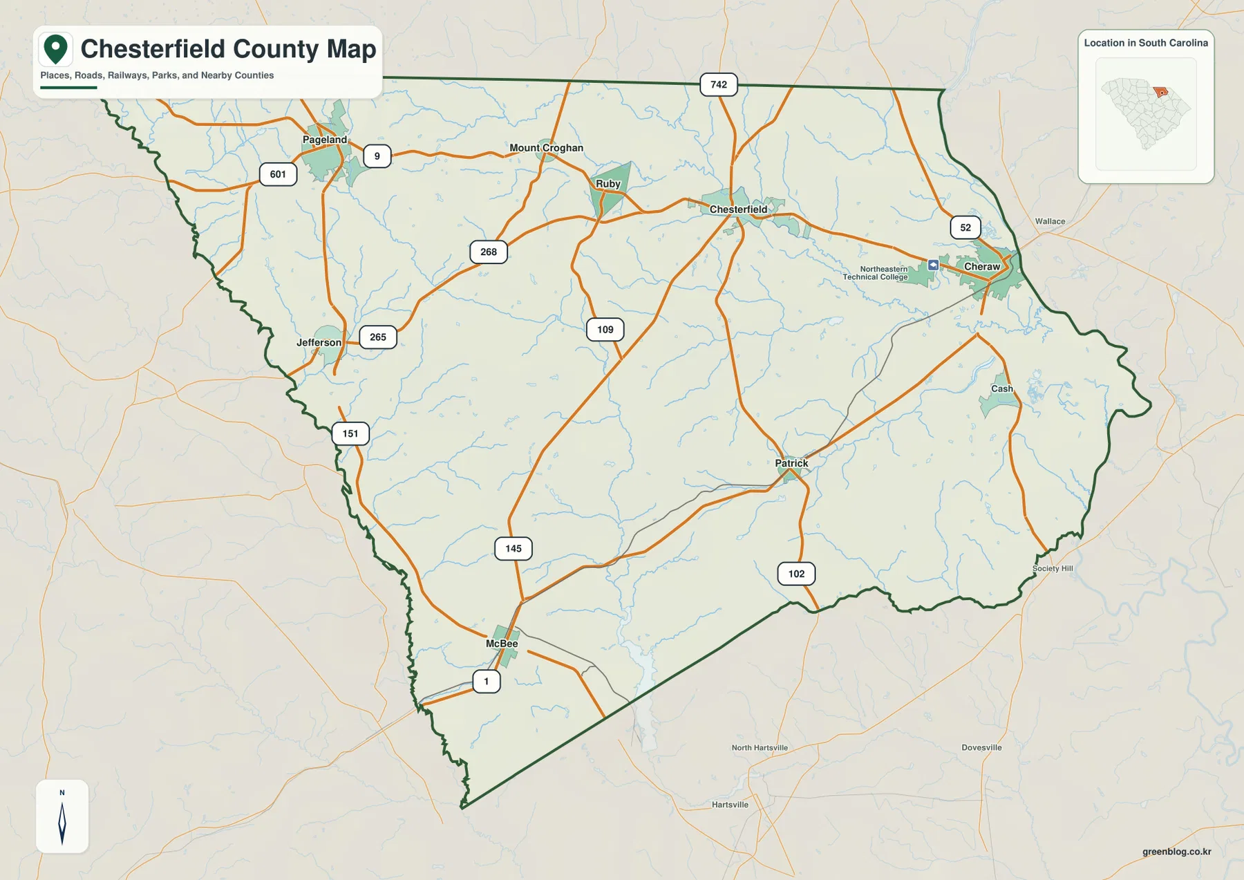
The Chesterfield County South Carolina Map places the county in the northeastern part of the state and gives two strong orientation points at opposite sides of the area: Cheraw in the east and Pageland in the northwest. This page includes a general county map with roads and communities, a city-index map that compares six major labeled places, and a terrain-and-water map centered on creeks, ponds, and relief. The maps can be viewed here as WEBP previews, and the matching high-resolution JPG files are available in a downloadable ZIP.
Chesterfield County makes more sense when the settlements are read as a network rather than as a single town surrounded by empty space. Cheraw, Pageland, Chesterfield, McBee, Jefferson, and Patrick occupy different parts of the county, while Ruby and Mount Croghan add more detail across the northern half. The general map also shows a road pattern that connects these places in several directions. Reading the roads, town locations, and waterways together gives a much clearer picture of the county than a plain outline would provide.
Table of Contents
Roads and places from Cheraw to Pageland
Cheraw stands out near the eastern side of the county, while Pageland anchors the northwest. Between them, the map labels Chesterfield, Ruby, and Mount Croghan, creating a useful chain of places across the northern half. Jefferson lies farther west, McBee is in the southwest, and Patrick appears in the southeast. This spread is important because it shows that the county does not have one compact settlement cluster. Instead, several communities provide reference points for different parts of the county, and each one becomes more meaningful when matched with the nearby road network.
Route 9 is one of the easiest east-west connections to follow on the map. It runs from the Pageland side through the Mount Croghan and Ruby area toward Chesterfield. Near Cheraw, Route 52 is prominent, while Route 601 appears near Pageland. Jefferson is close to Routes 151 and 265, McBee is near Route 1, and Patrick is associated with Route 102. Routes 109 and 145 help connect the broad middle and southern parts of the county. These labels are useful for regional orientation, although this is not intended to replace a turn-by-turn street map.
The eastern side around Cheraw contains a denser combination of roads, water features, and labeled places than some of the broad interior areas. Northeastern Technical College is also marked near Cheraw, giving another recognizable point on that side of the county. Farther west, the map opens up around Jefferson and the country between the northern towns and McBee. That contrast helps explain why the road map is valuable: it shows where named places are relatively close together and where longer stretches of the county are crossed mainly by connecting roads and smaller streams.
How the six highlighted communities are spread across the county
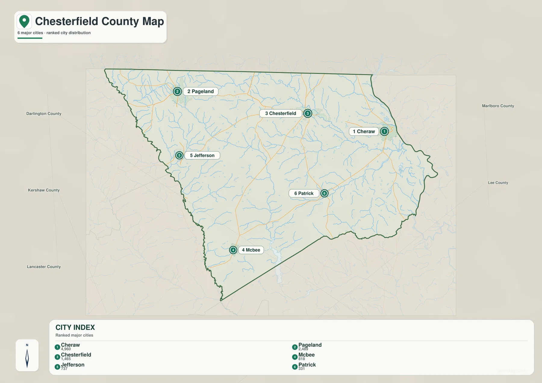
The city-index map focuses on six labeled places instead of attempting to show every community in Chesterfield County. The index printed on the map lists Cheraw at 4,960, Pageland at 2,469, Chesterfield at 1,465, McBee at 818, Jefferson at 737, and Patrick at 331. These figures are best used as a comparison among the six places included in this particular map. They should not be treated as the county’s total population or as a complete list of every incorporated or unincorporated place in the county.
The ranking becomes more useful when combined with location. Cheraw, the largest of the six in the map index, is near the eastern edge. Pageland is well to the northwest, and Chesterfield occupies the north-central portion between those two broad ends of the county. McBee and Patrick provide two separate southern reference points, while Jefferson sits on the western side. Because the top-ranked places are not all clustered around the county seat, the map gives a more balanced impression of where population centers and recognizable place names are distributed.
Neighboring county names printed around the map also help with orientation. Darlington, Kershaw, and Lancaster appear along the western and southwestern side of the surrounding area, while Marlboro and Lee are labeled to the east. The north edge of Chesterfield County reaches South Carolina’s northern state boundary. These surrounding labels are especially useful when comparing Chesterfield County with nearby county maps because they show which side of the outline faces each neighboring area rather than presenting the boundary as an isolated shape.
The city-index map is about relative position, not driving distance. A straight visual separation between Cheraw and Pageland does not account for road curves, route choices, or actual travel time. Its strength is different: it lets a reader see that Cheraw and Pageland occupy widely separated parts of the county, that Chesterfield sits between them in the northern half, and that McBee, Jefferson, and Patrick extend the settlement pattern toward the south and west. When planning a presentation or county profile, this view works well as a quick geographic overview before a more detailed road map is consulted.
Black Creek, Lake Robinson, and a dense network of smaller waters
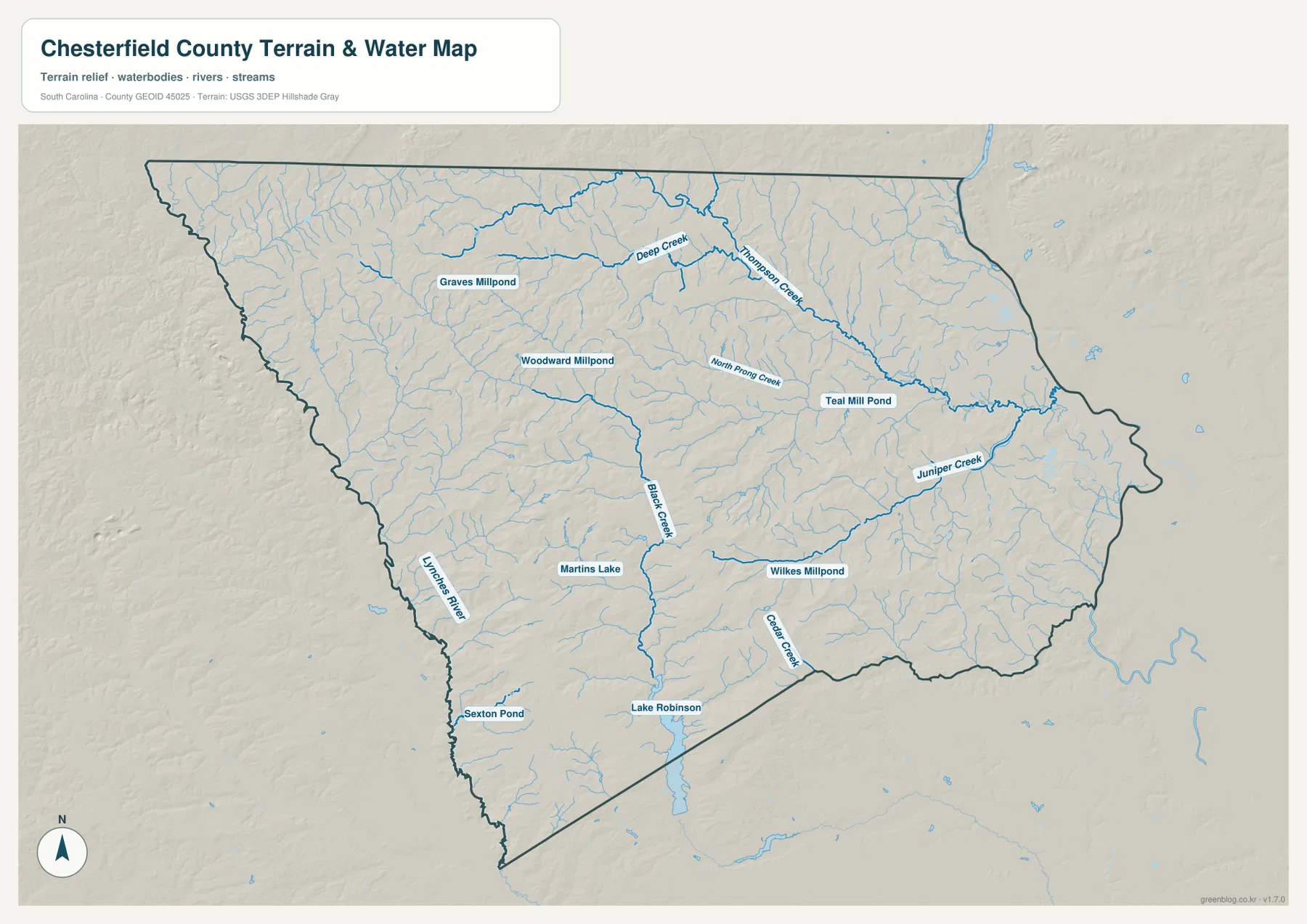
The terrain-and-water map changes the emphasis completely. Roads fade into the background while creeks, ponds, lakes, and shaded relief become the main features. Black Creek is one of the clearest named waterways, running through the central part of the county and continuing southward. Lake Robinson is easy to recognize near the southern edge, and the Lynches River follows the southwestern side of the county. Together, these features provide strong natural reference points that are not as obvious on the general road map.
Across the north, Deep Creek and Thompson Creek form another noticeable set of waterways. North Prong Creek is labeled farther south, and Teal Mill Pond appears nearby toward the east-central part of the county. Juniper Creek is prominent in the east, while Cedar Creek extends through the southeastern section. The map also labels Graves Millpond, Woodward Millpond, Martins Lake, Wilkes Millpond, and Sexton Pond. The number of named creeks and millponds is a defining feature of this map because it shows that Chesterfield County’s water geography is spread through many smaller branches rather than represented by only one major river.
The shaded terrain is relatively subdued compared with a steep mountain map, but it still reveals gentle changes in the surface and the way small drainage lines cut across the county. Fine tributaries appear in the north, center, and south, often connecting to the larger named creeks. The relief should be read as a broad visual reference rather than an exact elevation measurement. It is useful for seeing how waterways fit into the surrounding land, but it is not a survey product and should not be used to determine engineering elevations or property-level grades.
Comparing this map with the settlement map adds another layer of context. Cheraw sits in the eastern part of the county where several smaller waterways converge. Patrick is north of the Cedar Creek area, while the McBee side of the county is closer to Lake Robinson and the Lynches River. Black Creek crosses a broad interior area that has fewer large town labels, so it becomes an especially useful reference when describing the county between the main settlements. These relationships are visible on the supplied maps and make the water map more than a simple list of stream names.
Choosing the map that fits the task
For a first look at the county, the general map is usually the most useful because it combines the boundary, named places, and numbered routes. A reader can start with Cheraw and Pageland, locate Chesterfield between the two broad ends of the county, and then follow the routes toward Jefferson, McBee, and Patrick. It also works well when the goal is to compare Chesterfield County with surrounding county boundaries or to place a town name within the county without opening a full street map.
The city-index map is better when the question is where the six highlighted communities are located relative to one another and how the printed place rankings compare. The terrain-and-water map is the stronger choice for Black Creek, Lake Robinson, the Lynches River, and the many smaller creeks and millponds. Using the maps for their different strengths keeps the page clear: the road map explains access and place names, the city map emphasizes distribution, and the water map reveals natural features that are easy to miss in the other views.
| Area | Chesterfield County, South Carolina |
|---|---|
| County seat | Chesterfield |
| Highlighted places | Cheraw, Pageland, Chesterfield, McBee, Jefferson, Patrick |
| Selected waterways | Black Creek, Lynches River, Lake Robinson, Deep Creek, Thompson Creek |
| SCAC reference population | 43,273 |
| Land area | 799 sq mi |
| Founded | 1785 |
| Files provided | WEBP body previews and high-resolution JPG downloads |
The population, land-area, and founding figures in the table come from the reference information already included with the county package; they are not values read from the map image itself. The locations of communities, roads, and waterways, by contrast, are visible directly on the supplied maps. Keeping those two kinds of information separate makes the page easier to use: the reference numbers describe county scale, while the maps answer location questions.
Use the JPG files when a larger image is needed for a document, print layout, or offline reference. The WEBP versions are better for quick viewing on the page. Because the three files emphasize different information, choosing one by purpose is usually clearer than treating them as interchangeable: use the general map for roads and places, the city index for settlement distribution, and the terrain-and-water map for creeks, ponds, lakes, and relief.
Frequently Asked Questions
Why are Cheraw and Pageland useful reference points on a Chesterfield County map?
Cheraw is near the eastern side of the county, while Pageland is far to the northwest. Finding those two places first gives the reader two widely separated orientation points. Chesterfield lies in the northern interior between them, and McBee, Jefferson, and Patrick extend the pattern toward the south and west. The general road map then shows how numbered routes connect those parts of the county.
Which file is best for Black Creek and Lake Robinson?
The terrain-and-water map is the best choice. Black Creek is labeled through the central and southern part of the county, while Lake Robinson is visible near the southern boundary. The same map also includes the Lynches River, Deep Creek, Thompson Creek, Juniper Creek, Cedar Creek, and several named millponds, so it provides much more water detail than the general road map.
What is included in the downloadable ZIP?
The archive contains three high-resolution JPG files: the general Chesterfield County map, the city-index map, and the terrain-and-water map. Each JPG is 3638×2572 pixels. The article uses WEBP previews of the same map subjects so readers can decide which file they need before downloading the ZIP.
Map File Information
The ZIP contains the original high-resolution JPG versions of the general county map, city-index map, and terrain-and-water map. Each JPG is 3638×2572 pixels, providing a larger file than the WEBP previews used in the article.
- Included Files: general county map, city-index map, terrain-and-water map
Related Maps
Sources and map references
The article is based primarily on the places, roads, waterways, and terrain visible in the supplied Chesterfield County maps. The following official sources are useful for checking the county-level reference information and the types of geographic data represented in the maps.
- South Carolina Association of Counties – County Information: county seat, population, and land-area reference
- U.S. Census Bureau TIGER/Line Shapefiles: county and administrative boundary data
- USGS National Hydrography: streams, rivers, lakes, and other hydrographic data
- USGS 3D Elevation Program: elevation data used for terrain and shaded-relief reference
Green Map creates custom-edited map images using open geographic data sources such as geoBoundaries, Natural Earth, OpenStreetMap, and government open data.
These maps are edited visual materials, not raw data files, and are provided for education, documents, presentations, and graphic reference.