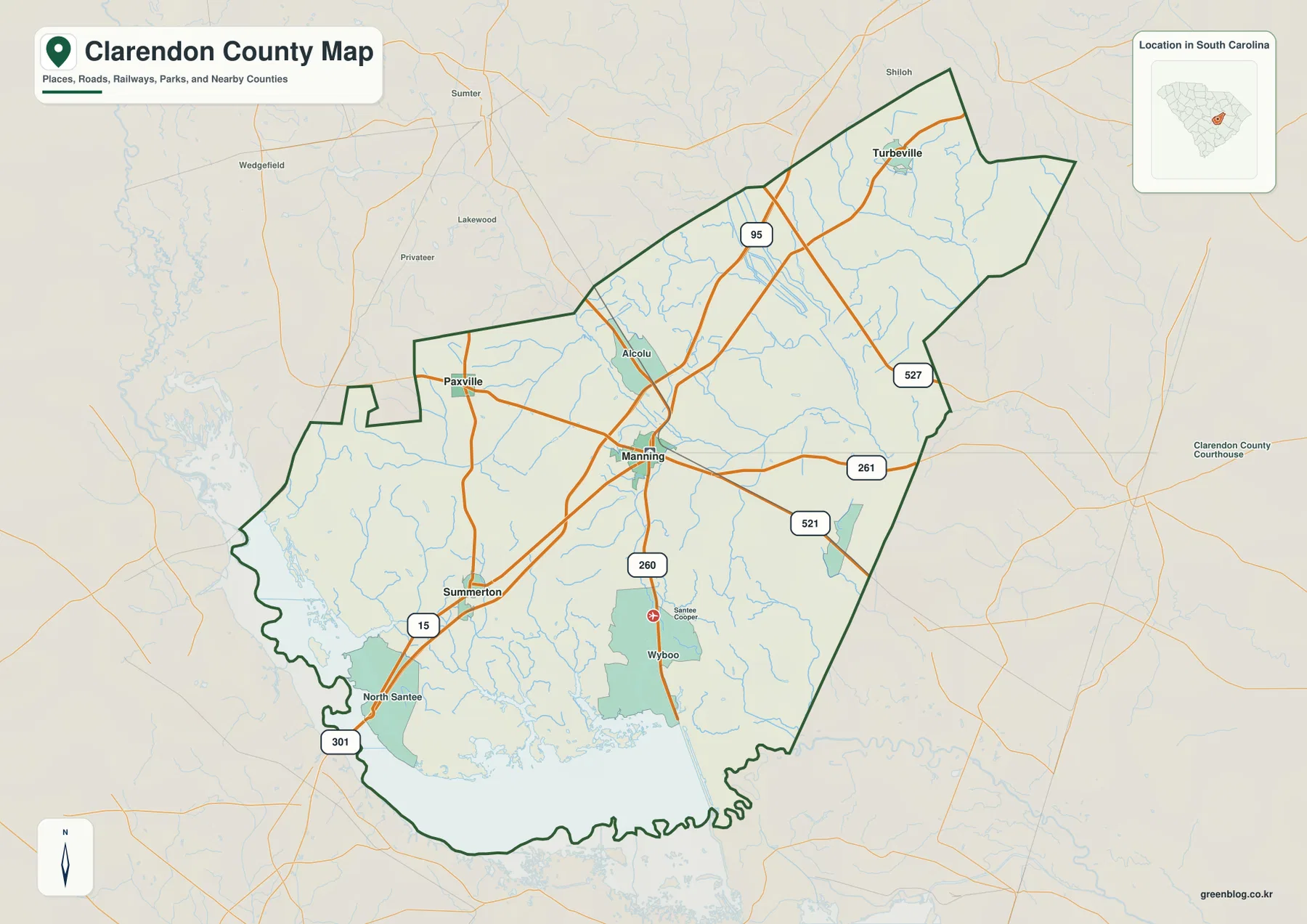
You can download the high-resolution A3 JPG files for this Clarendon County Map in one ZIP archive, while the WEBP images in the article provide quick previews. The maps place Manning, Summerton, Turbeville, Paxville, Alcolu, North Santee, and Wyboo alongside the county boundary, major numbered routes, and waterways. They include a general road-and-place view, a city-connections view centered on Manning, and a terrain-and-water view showing the Black River, Pocotaligo River, Santee River, smaller creeks, ponds, and broad southern water areas.
The shape of Clarendon County becomes easier to understand once the places are used as directional markers. Manning sits near the middle of the mapped road network, Summerton is to the southwest, Turbeville is far to the northeast, and Paxville lies to the west. The county narrows and stretches toward Turbeville, while the southwestern side bends around a much larger water-dominated edge. That contrast between the long northeastern reach and the irregular southern boundary gives the county a form that is difficult to describe well with an outline alone.
Table of Contents
Manning as the road reference between the county’s separate corners
Manning is the clearest orientation point on the general map because several numbered routes meet or pass close to it. From Manning, the eye can follow the road network northeast toward Turbeville, southwest toward Summerton, and west toward Paxville. Alcolu appears just north of the central part of the county, while Wyboo and the Santee Cooper label are farther south near the broad water area. North Santee is positioned near the southwestern edge. These names are spread far enough apart that the county does not read as a single compact settlement cluster.
The route numbers provide another layer of orientation without turning the map into a street guide. Route 95 runs through the central part of the county and continues toward the northeast. Routes 261 and 521 are prominent east of Manning, while 260 extends south from the Manning area. Around Summerton, routes 15 and 301 are visible, and route 527 appears near the northeastern side. The map does not show every local road or interchange, so it should not replace turn-by-turn navigation. Its strength is showing which major routes are associated with the principal named places and how those routes fit inside the county boundary.
The boundary itself changes character from one side of the county to another. The northeastern portion is longer and comparatively angular, while the southern and southwestern edges follow a much more irregular waterline. Surrounding county labels add useful context: Sumter and Richland are shown to the north, Williamsburg and Florence to the east, Orangeburg and Calhoun to the west, and Berkeley to the southwest. Reading these outer labels with Manning in the center helps place Clarendon County within the wider part of South Carolina rather than treating the map as an isolated shape.
What the Manning–Summerton–Turbeville–Paxville layout reveals
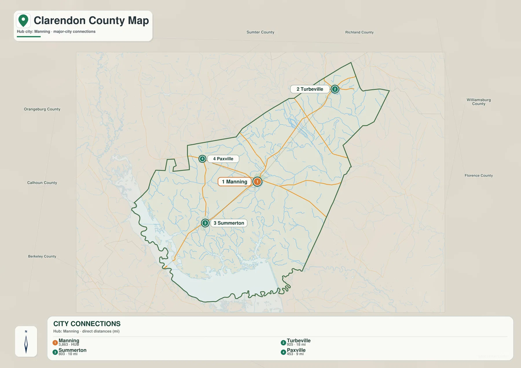
The city-connections map reduces the settlement pattern to four labeled reference places. Its index lists Manning at 3,863 and marks it as the hub, followed by Turbeville at 925, Summerton at 803, and Paxville at 453. The same panel prints direct distances from Manning: 18 miles to Turbeville, 10 miles to Summerton, and 9 miles to Paxville. Those distances are best treated as straight-line comparison values rather than driving mileage, but they quickly show which places are relatively close to Manning and which are farther away.
The four-place pattern closely follows the county’s shape. Turbeville occupies the long northeastern reach, Summerton anchors the southwestern side, and Paxville sits to the west of Manning. This means the highlighted places are not arranged along one simple east-west line. Instead, Manning functions as a practical center between three different directions. Once that pattern is clear, the unusual county outline makes more sense: the long upper section points toward Turbeville, while the broader lower section opens toward Summerton, Paxville, and the large water area along the south.
The surrounding-county labels are particularly helpful on this map because they show what lies beyond each side of the boundary. Sumter County and Richland County appear above Clarendon County, Williamsburg County and Florence County are on the eastern side, Orangeburg County and Calhoun County are to the west, and Berkeley County is southwest. The settlement pattern can therefore be read together with the administrative setting: Turbeville is close to the elongated northeastern end, while Summerton and Paxville are positioned nearer the broad western and southern portions.
A practical way to use the two road-oriented maps is to start with the city-connections panel and then return to the general map. First identify the three directions away from Manning: Turbeville northeast, Summerton southwest, and Paxville west. Then use the general map to match those places with the numbered routes. This sequence avoids getting lost among route labels and makes the county easier to explain in a report, classroom handout, or regional comparison where a full street map would be unnecessarily detailed.
From the Black River and Pocotaligo River to the Santee River edge
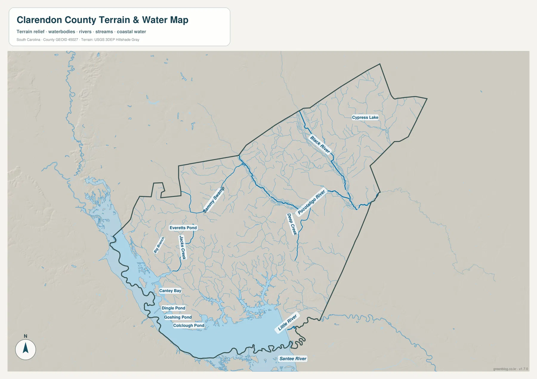
The terrain-and-water map changes the emphasis completely. In the northeast, the Black River is one of the strongest named features and is joined by many smaller tributaries. Farther south and west, the Pocotaligo River crosses the east-central part of the county, with Deep Creek connecting into the same broader drainage area. Sammy Swamp curves through the west-central side. Near the southwest, Jacks Creek and Big Branch appear around Everetts Pond before the drainage pattern opens into the much larger southern water system.
The southern edge is the most water-dominated part of the map. The Santee River is labeled along the bottom of the county, and the Little River enters the broad open-water area nearby. Several smaller named features cluster on the southwestern side, including Cantey Bay, Dingle Pond, Goshing Pond, and Colclough Pond. Cypress Lake is labeled in the northeastern part of the county. Taken together, these features explain why the southern boundary looks so winding on the general map: the county edge follows a landscape broken up by river channels, bays, ponds, and flooded margins rather than a simple straight line.
The relief shading is subdued rather than mountainous. Fine drainage lines spread through the northeast, center, and southwest, showing gentle surface changes and the routes that water follows across the county. The map is useful for seeing how streams branch and where named water features sit relative to the boundary, but it does not provide survey-grade elevation values. It should not be used to infer property-level slope, flood limits, or engineering elevations. Its value is regional: it shows the arrangement of rivers, creeks, swamps, ponds, and broad water areas in relation to one another.
Comparing the water map with the road map creates several useful location references. The northeastern side toward Turbeville is associated with the Black River and a dense network of small tributaries. East and southeast of Manning, the Pocotaligo River and Deep Creek provide natural reference lines. Toward Summerton and North Santee, the southern water edge becomes much more prominent. The 260 corridor south of Manning also leads visually toward the large water area. These relationships make it easier to explain why the county’s road pattern and boundary shape differ between the northeast and southwest.
Which Clarendon County view fits the question?
For general orientation, the road-and-place map is the strongest starting point. It combines the county outline with Manning, Summerton, Turbeville, Paxville, Alcolu, North Santee, Wyboo, and several major numbered routes. It is especially helpful when the goal is to explain where a place sits inside the county or how the northeastern and southwestern parts connect. The surrounding county names also make it suitable for comparing Clarendon County with neighboring administrative areas.
The city-connections map is better when the question is specifically about the four highlighted places and their relative spacing. The direct-distance labels from Manning provide a quick comparison without the clutter of a complete road network. The terrain-and-water map should be used when the focus shifts to the Black River, Pocotaligo River, Santee River, Little River, Sammy Swamp, ponds, and the irregular southern water edge. Choosing the map by subject keeps the explanation accurate instead of asking one image to answer every geographic question.
| Area | Clarendon County, South Carolina |
|---|---|
| County seat | Manning |
| Useful place references | Manning, Summerton, Turbeville, Paxville, Alcolu, North Santee, Wyboo |
| Selected waterways | Black River, Pocotaligo River, Santee River, Little River, Sammy Swamp, Cypress Lake |
| Package reference population | 31,144 |
| Land area | 607 sq mi |
| Founded | 1785 |
| Files provided | WEBP article previews and high-resolution JPG downloads |
The population, land-area, and founding figures in the table come from the reference information already included with the package; they are not values read from the map image. The place positions, route numbers, and named waterways are visible on the supplied maps. Keeping those two categories separate is important: the statistics describe county scale and background, while the maps answer questions about location, orientation, roads, and water features.
Use the JPG files when you need a larger image for a document, print layout, presentation, or offline reference. The WEBP versions are intended for quick viewing on the page. The files cover the same county but emphasize different information, so it is usually clearer to select the road map for routes and places, the city-connections map for the four highlighted communities, and the terrain-and-water map for rivers, streams, ponds, and relief.
Frequently Asked Questions
How can I use Manning to orient myself on the Clarendon County map?
Find Manning first, then use Summerton to the southwest, Turbeville to the northeast, and Paxville to the west as three directional markers. The city-connections map prints direct distances of 10 miles to Summerton, 18 miles to Turbeville, and 9 miles to Paxville. Those are useful for comparing spacing, but actual driving mileage and travel time should be checked with a current road-navigation source.
Which map best explains the winding southern boundary?
The terrain-and-water map is the best choice because it shows the Santee River, Little River, the broad southern water area, and smaller features such as Cantey Bay, Dingle Pond, Goshing Pond, and Colclough Pond. It also shows the Black River and Pocotaligo River farther north, making it easier to compare the county’s different drainage zones.
What files are included in the downloadable ZIP?
The archive contains three high-resolution JPG files: the general Clarendon County map, the city-connections map, and the terrain-and-water map. Each JPG is 3638×2572 pixels. The article uses WEBP previews of the same map subjects so you can review the content before choosing which downloaded image to use.
Map File Information
The ZIP contains the original high-resolution JPG versions of the general county map, city-connections map, and terrain-and-water map. Each JPG is 3638×2572 pixels, providing a larger file than the WEBP previews used in the article.
- Included Files: general county map, city-connections map, terrain-and-water map
Related Maps
Sources and map references
The place, road, boundary, and water descriptions in this article are based primarily on the supplied Clarendon County maps. The following official resources are useful for checking county reference information and the types of geographic data represented in the maps.
- South Carolina Association of Counties – County Information: county-level reference information
- U.S. Census Bureau TIGER/Line Shapefiles: county and administrative boundary data
- USGS National Hydrography: rivers, streams, lakes, and other hydrographic data
- USGS 3D Elevation Program: elevation and terrain reference data
- South Carolina Geological Survey: South Carolina geology and map resources
Green Map creates custom-edited map images using open geographic data sources such as geoBoundaries, Natural Earth, OpenStreetMap, and government open data.
These maps are edited visual materials, not raw data files, and are provided for education, documents, presentations, and graphic reference.