Grimes County stretches across a long north–south section of southeast-central Texas, with Navasota near the southern end, Anderson farther north, and smaller communities such as Bedias and Iola spread across the upper half. The maps on this page connect the county boundary with numbered highways, ranked communities, the Brazos and Navasota river corridors, named creeks and lakes, and local elevation. You can download the supplied maps as high-resolution A3 JPG files in one ZIP from the download box near the end of the article.
The county has a noticeably irregular western edge, while much of the eastern boundary is straighter. That contrast makes sense when the water and elevation maps are viewed beside the base map. Low green terrain follows the broad western river bottoms, while tighter bands of higher relief become more common through the center and east. The result is a county where settlement, roads, streams, and hills can be compared without treating the landscape as one uniform surface.
This package contains a county map, a ranked city map, a terrain-and-water map, and an elevation map. The descriptions below stay with names, route numbers, water features, and elevation values that are visible in those supplied images. They are designed for orientation, printing, and general reference rather than parcel research, flood determination, surveying, or engineering measurement.
Table of Contents
A long settlement pattern runs from Navasota north toward Anderson, Bedias, and Iola
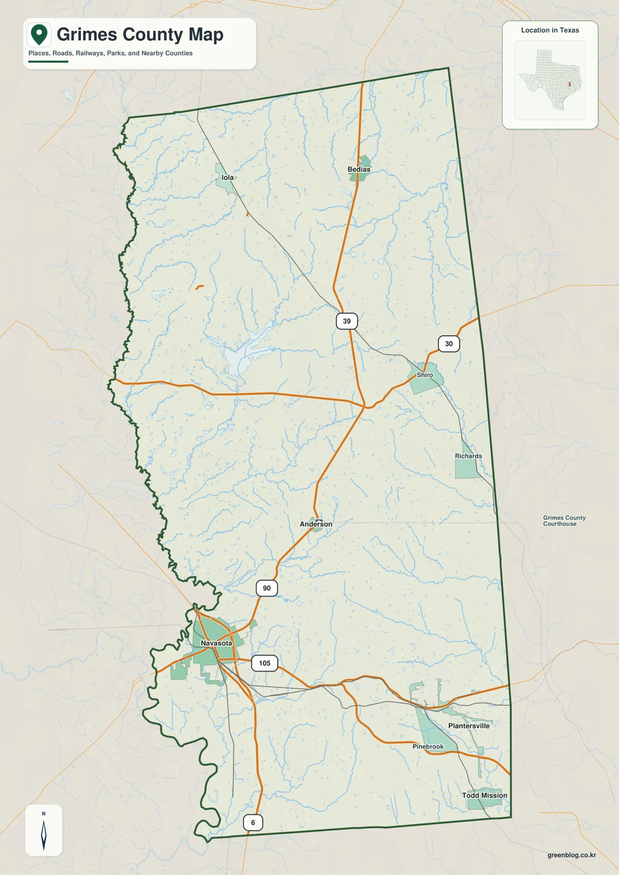
Navasota is the strongest visual anchor on the county map. It sits close to the southwest side of Grimes County where several transportation lines meet, and State Highway 90 heads north from the city toward Anderson. Anderson is much smaller on the map, but its position near the lower center of the county makes it a useful reference point between the dense road pattern around Navasota and the more widely separated communities farther north.
North of Anderson, the settlement pattern splits. Iola lies toward the northwest, while Bedias is farther east, close to the north-central part of the county. Shiro and Richards appear along the eastern side, and Plantersville, Pinebrook, and Todd Mission form additional reference points in the southeast. Because these places are dispersed rather than clustered around a single central city, the full county outline is more informative than a tight view of only one community.
The road numbers help connect those places. Highway 90 links Navasota and Anderson, Highway 105 crosses the southern part of the county toward Plantersville, Highway 39 runs through the north-central area near Bedias, and Highway 30 reaches eastward through the central part near Shiro. Highway 6 continues south through Navasota and beyond the county boundary. Together, these routes make the southern half look busier while the northern communities remain farther apart.
The ranked city map makes Navasota stand apart from the smaller communities
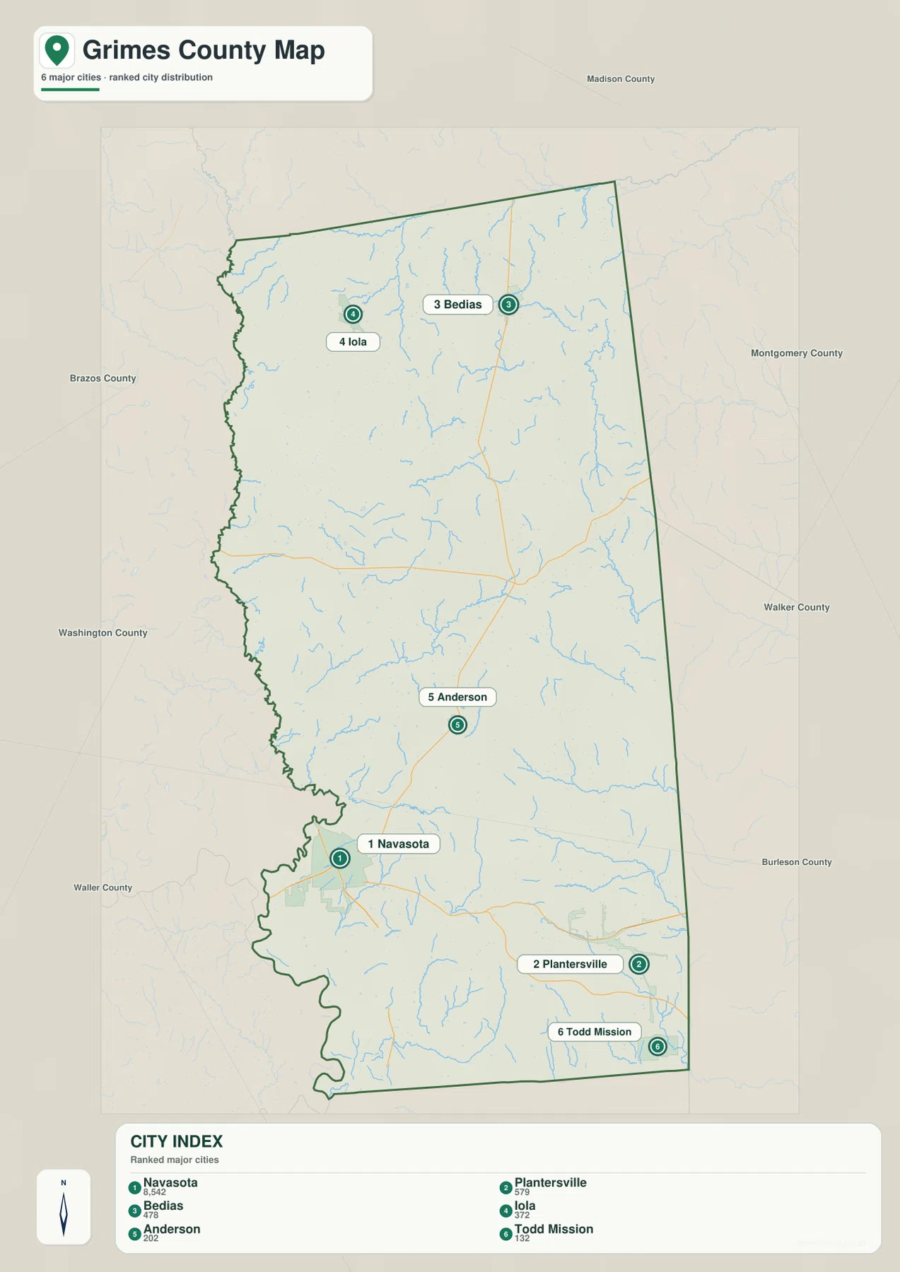
The city map ranks six places and places each marker inside the county outline. Navasota is ranked first, followed by Plantersville, Bedias, Iola, Anderson, and Todd Mission. The ranking is useful because the map does not imply that every incorporated place has the same scale. Navasota clearly serves as the dominant urban reference, while the other ranked communities are smaller and spread across different parts of the county.
Their locations create a strong geographic contrast. Navasota sits near the southwest side; Plantersville and Todd Mission are in the southeast; Anderson is near the lower middle; Bedias and Iola are well to the north. A reader looking only at the county seat could easily miss how much of the mapped urban weight lies farther south around Navasota, while a reader looking only at Navasota could overlook the large rural distances separating the northern communities.
Neighboring county labels add another layer of orientation. Brazos County and Washington County lie to the west, Madison County is to the north, Montgomery and Walker counties are on the eastern side, Burleson County is southeast, and Waller County is southwest. These labels are especially useful for Navasota, which is close to the western side of Grimes County, and for Plantersville and Todd Mission, which sit much nearer the eastern and southeastern edges.
The Brazos and Navasota rivers frame a dense network of smaller creeks and lakes
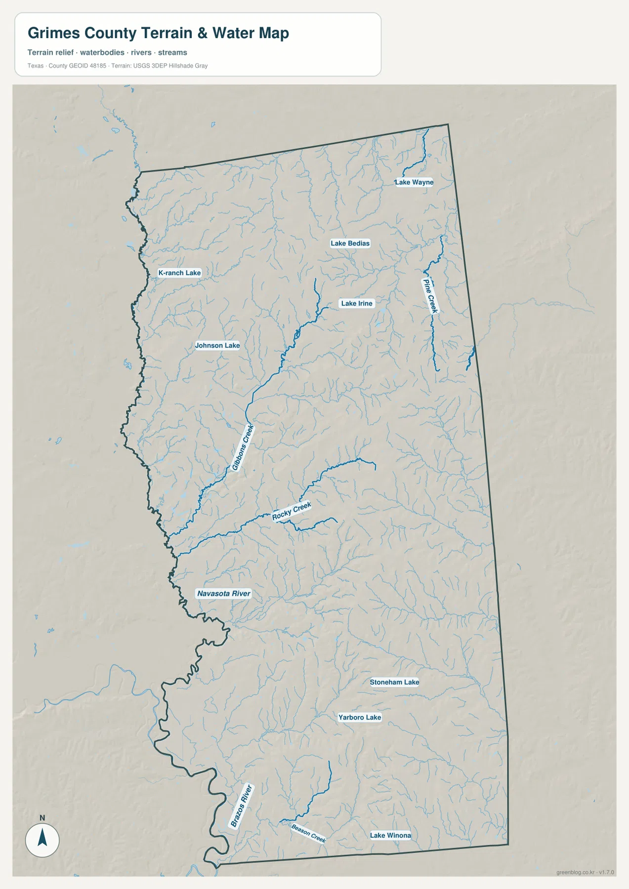
The terrain-and-water map is dominated by two large river corridors along the western side. The Brazos River bends along the southwest edge, while the Navasota River is labeled farther north near the west-central boundary. Between and east of those larger rivers, the map shows many smaller drainage lines, so the county is not simply a pair of river valleys with dry interior land between them.
Gibbons Creek is one of the clearest named streams in the central-western part of the map, and Rocky Creek crosses the area just to its south. Pine Creek is labeled in the northeast, while Beason Creek appears near the southern edge close to the Brazos River. These named streams provide useful reference lines when comparing the water map with the elevation image because many of the narrow lower areas follow the same general corridors.
Several lakes are identified as well. Lake Wayne and Lake Bedias appear in the north, K-ranch Lake and Johnson Lake are farther west, and Lake Irine is near the central part of the county. Stoneham Lake and Yarboro Lake are shown farther south, with Lake Winona near the southeast corner. The named water bodies are scattered rather than concentrated in one reservoir district, which makes the water map helpful for locating smaller local features that are easy to miss on the road-focused county map.
Elevation rises from the western river bottoms into broken central and eastern uplands
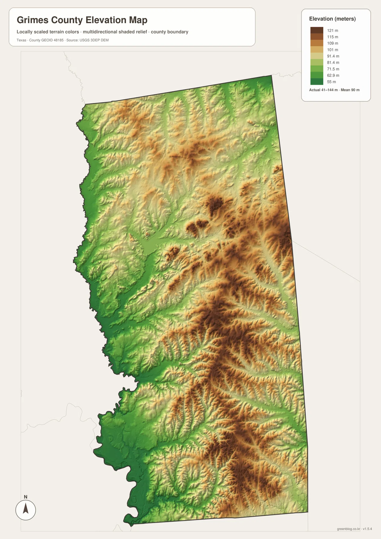
The elevation legend gives an actual county range of about 41 to 144 meters, with a mean near 90 meters. Green represents the lower ground, while yellow and brown indicate progressively higher terrain. The broadest low areas are visible along the west and southwest, matching the general position of the Brazos and Navasota river bottoms shown on the water map.
Higher ridges become much more frequent through the center, east, and southeast. The brown areas do not form one continuous plateau; instead, they break into many narrow ridges separated by lower green channels. This gives the county a rolling, dissected appearance, especially in the lower eastern half where the relief image shows closely spaced hills and valleys.
The northern part also has visible relief, but the strongest clusters of darker high ground are more obvious farther south and east. When Gibbons Creek, Rocky Creek, or the western river corridors are mentally transferred from the water map to the elevation map, the relationship between streams and lower terrain becomes much easier to see. The surface is generalized for county-scale viewing, so it should not be used to determine the exact elevation of a property, road grade, or construction site.
Road numbers tie the southern city center to a much more dispersed northern county
The base map and city map together show why Navasota is such a practical starting point. Highways 6, 90, and 105 are all visible around the southern city, giving it several clear travel directions. Highway 90 then provides a simple line toward Anderson, while routes farther north divide toward Bedias, Iola, and the central-eastern communities. The contrast between a busy southern junction and the wider spacing of northern places is one of the county’s most noticeable map features.
That pattern also helps when looking near the boundaries. Iola sits closer to the Brazos County side, Bedias is nearer the northern edge below Madison County, and Shiro and Richards sit toward the east. Plantersville and Todd Mission are far enough southeast that they are better understood in relation to Montgomery, Walker, and Burleson counties than by using Navasota alone as a reference. The neighboring labels keep the county from feeling isolated from the roads and communities immediately outside it.
Physical relief adds another reason to compare the maps rather than reading the roads by themselves. Western routes cross or follow lower river-country terrain, while roads through the center and east encounter more closely spaced ridges and valleys on the elevation image. The maps do not calculate slopes or travel times, but they do make it clear that the same county contains both broad low corridors and more broken upland terrain.
Choose the map by the question you need to answer
For locating towns, numbered highways, railways, and the county outline, start with the county map. Navasota and Anderson provide quick reference points before moving north toward Bedias and Iola or east toward Shiro and Richards. If the goal is to compare the relative prominence and distribution of the main communities, the ranked city map removes much of the extra road detail and makes the six selected places easier to compare.
Use the terrain-and-water map when the question involves rivers, creeks, lakes, or the broad shape of the lower valleys. Then switch to the elevation map to see how the green river bottoms relate to the higher brown ridges. The two natural-feature maps are especially effective as a pair because a named creek on one image often lines up with a lower corridor on the other.
The ZIP below contains four high-resolution A3 JPG files matching the county, city, water, and elevation maps shown in the article. The web images are convenient for quick viewing, while the larger JPG files are better suited to printing, classroom materials, presentations, or keeping an offline reference copy.
Keep the original aspect ratio when printing and check the paper-size and margin settings before sending the image to a printer. The maps are intended for geographic reference. For legal boundaries, parcel decisions, flood-risk determinations, engineering work, or survey-grade elevation, consult the responsible agency and the latest authoritative data.
Frequently Asked Questions
Which place is the easiest starting point on a Grimes County map?
Navasota is the easiest starting point because it is ranked first on the supplied city map and several numbered highways meet around it on the county map. From there, Highway 90 provides a clear route toward Anderson, and the northern communities of Bedias and Iola can be added once the southern part of the county is oriented.
Where are the Brazos and Navasota rivers shown?
The Brazos River is labeled along the southwest edge of the terrain-and-water map, while the Navasota River appears farther north near the west-central boundary. Gibbons Creek, Rocky Creek, Pine Creek, and other smaller streams fill much of the area between the major river corridors.
What elevation range does the supplied Grimes County map show?
The elevation legend reports an actual range of roughly 41 to 144 meters and a mean near 90 meters. The lowest areas are most extensive along the western and southwestern river bottoms, while higher ridges are more common through the central, eastern, and southeastern parts of the county.
Sources and map-reference notes
For official boundary and road-reference data, see the U.S. Census Bureau TIGER/Line Shapefiles. Water features can be checked against USGS National Hydrography. The descriptions in this article prioritize the names and locations actually visible in the supplied Grimes County map package.
Elevation-reference information is available from the USGS 3D Elevation Program, and the USGS The National Map Viewer provides a way to inspect multiple federal geographic datasets in one viewer. These sources are appropriate for checking general geographic context; specialized legal or engineering questions require the relevant current agency records.
Map File Information
The ZIP contains four high-resolution A3 JPG maps for Grimes County, covering roads and settlements, ranked cities, water and terrain, and elevation.
- File Type: JPG
Related Maps
- Walker County Texas map
- Waller County Texas map
- Washington County Texas map
- Robertson County Texas map
- San Jacinto County Texas map
Green Map creates custom-edited map images using open geographic data sources such as geoBoundaries, Natural Earth, OpenStreetMap, and government open data.
These maps are edited visual materials, not raw data files, and are provided for education, documents, presentations, and graphic reference.