Appling County sits in southeastern Georgia, where Baxley provides the clearest starting point for understanding the county’s roads, towns, waterways, and low-relief terrain. The main county map shows the boundary and numbered highways around Baxley, while the companion city map separates the three incorporated municipalities—Baxley, Graham, and Surrency—so their positions are easier to compare. A water map traces the Altamaha River and a long list of creeks, and the elevation map shows a locally scaled range of about 16 to 75 meters.
The WEBP maps on this page are previews. If you need files for printing or a document, you can download one ZIP containing four high-resolution A3 JPG maps: the general county map, city map, terrain-and-water map, and elevation map. Each version emphasizes a different part of the same county, so you can use a clean road-and-place reference for orientation, switch to the water map for named streams, or use the shaded elevation map when the height of river corridors and uplands matters.
Table of Contents
Start with Baxley and the county road frame
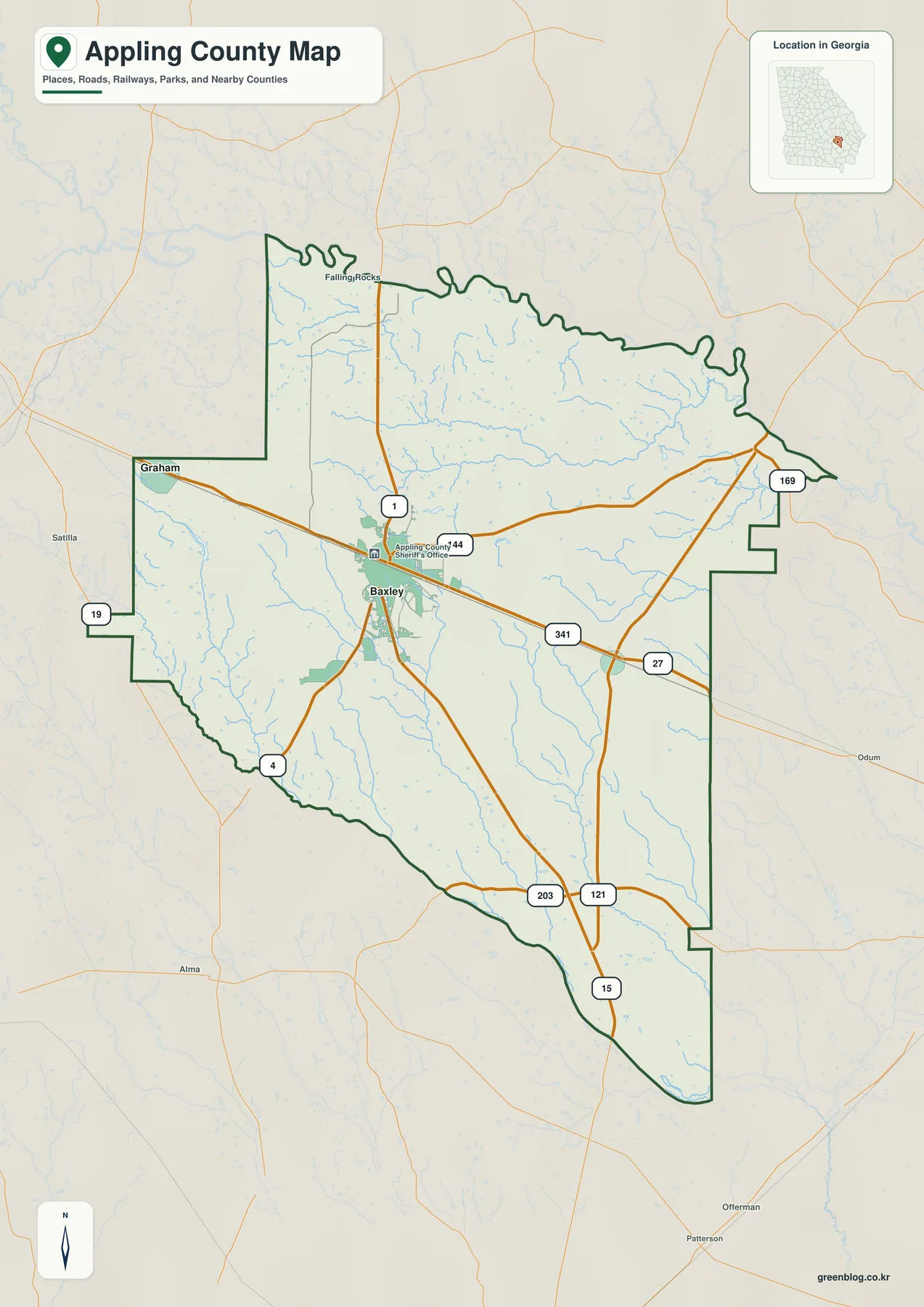
Baxley is the strongest orientation point on the general map because several routes meet around the city. U.S. 1 and U.S. 341 are labeled there, and the map also shows Route 27 along with numbered routes 4, 15, 19, 44, 121, 169, and 203 in different parts of the county. Graham appears west of Baxley and Surrency lies to the southeast. Once those three places are located, the long rural spaces between them become easier to understand: roads cross broad areas with many small streams but relatively few large settlement labels.
The county outline is also worth noticing. Its northern edge follows a strongly meandering river boundary, while the west and east sides include several step-like changes before the county narrows toward the south. Labels outside the boundary, including Satilla, Alma, Odum, Offerman, and Patterson, provide additional regional context without turning the page into a full southeastern Georgia road atlas. Use this map for countywide orientation and for explaining the position of major routes, not for parcel boundaries, street-level navigation, or legal municipal limits.
| State | Georgia |
|---|---|
| County seat and largest city | Baxley |
| Incorporated municipalities | Baxley, Graham, Surrency |
| 2020 population | 18,444 |
| 2020 land area | 508.27 square miles |
| 2020 population density | 36.3 people per square mile |
| Elevation shown on map | about 16–75 m, mean 52 m |
| Download | one ZIP with four high-resolution A3 JPG maps |
Three towns across the middle of the county
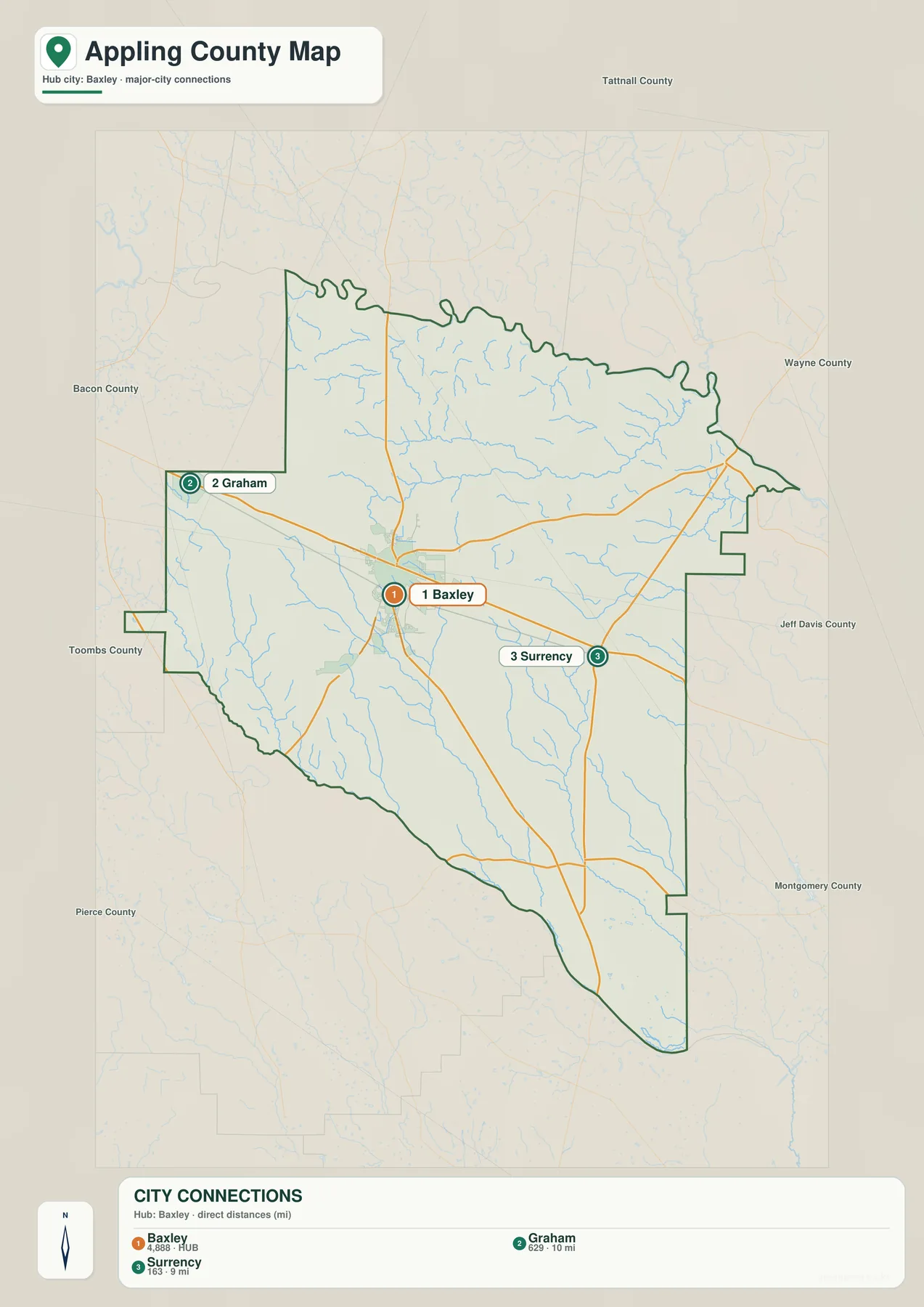
The city map strips away some of the general-map detail and makes the municipal pattern easy to see. Baxley is marked as the hub. Graham is labeled about 10 miles away by direct distance, while Surrency is shown about 9 miles from Baxley. Those numbers are not driving distances, but they give a useful sense of scale. The three incorporated places are close enough to read as one countywide settlement pattern, yet large rural areas still occupy most of the map outside their immediate surroundings.
Graham sits west to northwest of Baxley, and Surrency lies southeast of the county seat. The road corridor through these places helps explain why Baxley works so well as the central reference point. The frame also names nearby counties and surrounding areas, including Bacon, Toombs, Tattnall, Wayne, Jeff Davis, Montgomery, and Pierce. Those labels are useful when a reader already knows one of the surrounding counties and wants to place Appling County in a broader southeastern Georgia setting.
The arrangement also has a historical explanation in the supplied county material. The Macon and Brunswick Railroad reached the area in 1870, and settlements developed around its stations. Graham, Baxley, and Surrency grew along that transportation route, and the county seat moved from Holmesville to Baxley in 1874. Baxley was incorporated in 1875. The present city map therefore reflects more than current place names; it preserves a settlement pattern shaped by rail access and by the later road network centered on Baxley.
The Altamaha edge and a branching creek network
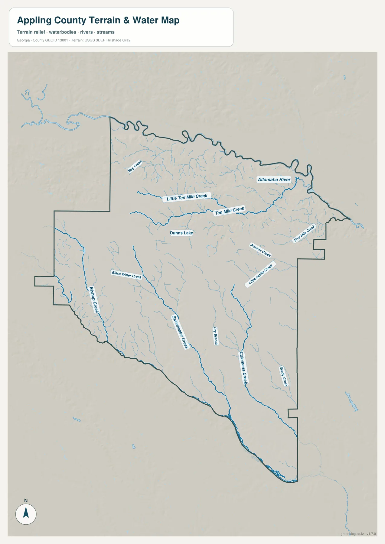
The water map changes the emphasis completely. The Altamaha River forms the dominant feature along the north, bending across the upper edge of the county. Below it, Little Ten Mile Creek and Ten Mile Creek extend across the northern interior, while Bay Creek appears farther west. Dunns Lake is labeled near the north-central part of the map. This view makes it clear that the county is not simply an open block of rural land between roads; a dense network of smaller waterways occupies much of the interior.
Farther south and east, the map labels Buck Water Creek, Bishop Creek, Sweetwater Creek, Dry Branch, Colemans Creek, Reedy Creek, Atkinson Creek, Five Mile Creek, and Little Satilla Creek. Some of these channels run for long distances through the county before joining larger drainage systems. Their names are much easier to distinguish here than on the general road map because the water layer has fewer competing labels. For a lesson about drainage, wetlands, stream corridors, or the relationship between roads and water crossings, this is the most informative of the four files.
The Altamaha also matters to the county’s history. The supplied background material describes the river as a route used to move timber, farm products, and turpentine-related goods toward coastal markets. That history fits the broader pine and river landscape associated with Appling County. The purpose of this map is not to reconstruct nineteenth-century transportation, but the visible river corridor provides a clear geographic setting for understanding why water access and timber activity were important to the area.
A low-relief landscape from 16 to 75 meters
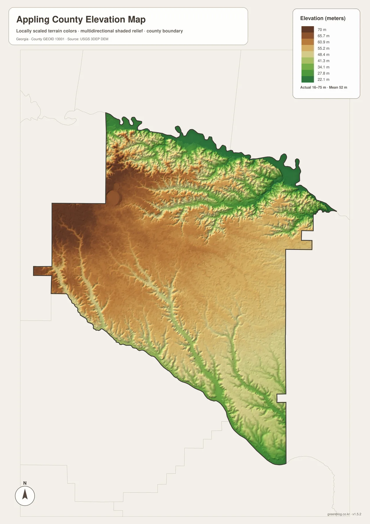
The elevation map is locally scaled, so its colors are designed to show small differences inside Appling County rather than compare the county with mountain regions elsewhere. The legend gives an actual range of roughly 16 to 75 meters and a mean elevation of 52 meters. Brown and tan areas are relatively higher, while green areas are lower. Much of the west and central interior appears in the warmer colors, whereas lower ground follows the northern river edge and several stream valleys that extend south and southeast.
When the elevation and water maps are compared side by side, the relationship is straightforward. Green strips on the elevation map often align with the long creek corridors shown in blue on the water map. The low northern edge corresponds to the Altamaha River, and narrow lower zones also follow south-running streams such as Sweetwater Creek and Colemans Creek. The differences are modest rather than mountainous, which is consistent with the county’s southeastern Coastal Plain setting and its broad, gently varying rural landscape.
This version is useful when a plain boundary map does not explain enough. A school project can use it to show why streams occupy lower ground; a local overview can place the river corridor in relation to slightly higher interior land. If the subject is simply “Where is Baxley?” the city or general map will communicate more quickly. If the subject is terrain, drainage, or why particular creek lines stand out, the elevation map adds information that the road map cannot provide.
How settlement and transport shaped today’s map
Appling County was created in December 1818 from a much larger territory south of the Altamaha River and was named for Daniel Appling, a soldier associated with the War of 1812. The early county covered far more land than the present outline. Over time, new counties were formed from portions of that original territory, leaving the irregular boundary seen on today’s maps. This history is useful context because the modern county shape is the result of repeated administrative change, not a simple geometric division drawn all at once.
Holmesville served as the early county seat, but Baxley became more important after the railroad arrived. The seat moved to Baxley in 1874, and the town was incorporated the following year. On the present map, that decision still makes geographic sense: Baxley is centrally placed among the three incorporated municipalities and is where major routes converge. Graham and Surrency remain smaller, while broad rural areas stretch beyond the central transportation corridor.
The population figures reinforce that impression. The supplied Census-based table uses a 2020 population of 18,444, a land area of 508.27 square miles, and a density of 36.3 people per square mile. Those numbers help explain why the map contains large spaces between the named municipalities. The county’s pine landscape, timber history, river transport, farms, and wet lowlands all belong to a setting where settlement is less continuous than in an urban county. The maps work best when that rural scale is kept in mind.
For readers studying local history, the four maps can be combined rather than treated as separate products. The city map supplies the settlement sequence, the general map shows today’s road network, the water map adds the Altamaha and creek corridors, and the elevation map shows why those waterways occupy lower ground. Together they provide a concise geographic backdrop for reading historical accounts of rail stations, the county-seat move, timber rafting, and other activities described in the county sources.
Which of the four maps should you use?
Choose the version that matches the question you are trying to answer. A single crowded map would make road labels, stream names, city markers, and elevation shading compete for attention, so the package separates those tasks. All four downloadable files use an A3 layout, making it practical to print one map by itself or place two versions side by side in a report or classroom handout.
- General county map: best for the boundary, Baxley, numbered roads, broad place context, and a quick countywide reference.
- City map: best for comparing Baxley, Graham, and Surrency and for showing their direct distance relationship.
- Terrain and water map: best for the Altamaha River, Dunns Lake, and named creeks such as Ten Mile, Sweetwater, and Colemans.
- Elevation map: best for comparing relatively higher interior ground with lower river and creek corridors across the 16–75 m local range.
These files are reference graphics, not operational GIS layers. For turn-by-turn travel, use a current navigation or transportation source. Parcel ownership, zoning, flood determinations, and legal boundaries require the latest records from the responsible county or agency. Keeping that limitation clear lets the downloadable maps do what they are designed to do well: provide readable countywide context and printable geographic reference.
Frequently Asked Questions
Where should I start when reading the Appling County map?
Start with Baxley. It is the county seat and largest city, and the general map shows several important roads meeting around it. From Baxley, locate Graham to the west or northwest and Surrency to the southeast. That sequence quickly establishes the position of the county’s three incorporated municipalities before you move on to water or elevation detail.
What do the water and elevation maps show when viewed together?
They show that many of the lower areas follow rivers and creeks. The elevation map uses a local range of about 16–75 meters, and lower green strips often match the waterways labeled on the terrain-and-water map. The Altamaha edge is especially easy to compare, along with long creek corridors that run through the central and southern parts of the county.
What is included in the downloadable ZIP?
The ZIP contains four high-resolution A3 JPG files: a general county map, a city map, a terrain-and-water map, and an elevation map. The WEBP images in the article are lighter previews for on-page viewing. The JPG files are suited to printing and document use, but they should not replace current legal boundary, parcel, flood, or navigation data.
Map File Information
Appling County map files
- Included Files: General county, city, water, and elevation maps
- File Type: Four high-resolution A3 JPG files bundled in one ZIP archive
- Intended Use: Printing, education, presentations, and map-based projects
Related Maps
Sources and reference data
County population, area, and historical context were retained from the supplied article and the sources below. Boundary, hydrography, and elevation descriptions also follow the four supplied map previews and the official data references included with the package.
- U.S. Census Bureau QuickFacts – Appling County, Georgia
- New Georgia Encyclopedia – Appling County
- Georgia Department of Community Affairs – Appling County comprehensive plan
- U.S. Census Bureau TIGER/Line Shapefiles
- USGS National Hydrography
- USGS 3D Elevation Program
Green Map creates custom-edited map images using open geographic data sources such as geoBoundaries, Natural Earth, OpenStreetMap, and government open data. These maps are edited visual materials, not raw data files, and are provided for education, documents, presentations, and graphic reference.